Items Similar to Ornate 1850s Map of the United States: Featuring Iconic Landmarks and Portrets


Want more images or videos?
Request additional images or videos from the seller
1 of 6
Ornate 1850s Map of the United States: Featuring Iconic Landmarks and Portrets
$335.06
£250.25
€280
CA$461.61
A$503.07
CHF 266.40
MX$6,042.40
NOK 3,372.65
SEK 3,100.82
DKK 2,133.12
About the Item
Ornate 1850s Map of the United States: Featuring Iconic Landmarks and Historical Portraits
This decorative 19th-century map of the United States, created by J. Rapkin and published by J
F Tallis, offers a captivating blend of cartography and artistic embellishments. Featuring hand-colored state boundaries, it highlights the territorial divisions and geographical features of the U.S. during the mid-19th century.
The map is surrounded by stunning illustrations by J. Marchant, engraved by J. Rogers, showcasing prominent landmarks such as the Capitol in Washington and the Washington Monument. Portraits of George Washington and Benjamin Franklin grace the sides, adding a patriotic touch to the design. The vignettes also include scenes of bison hunting on the plains and an early depiction of Native American life, reflecting the diversity of the American experience at the time.
This map was produced during a period of rapid territorial expansion and growth, making it a fascinating historical artifact. Its intricate border, detailed engravings, and blend of cultural and geographical elements make it ideal for collectors of antique maps and Americana.
Year of Publication: Circa 1850s
Condition: Very good with vibrant hand-coloring, crisp engraving details, and minimal signs of age.
Keywords: United States, antique map, 19th-century map, decorative map, J. Rapkin, J
F Tallis, hand-colored map, Victorian cartography, engraved map, historical geography, American expansion, Capitol Washington, Washington Monument, George Washington, Benjamin Franklin, Native American life, bison hunting, territorial divisions, American history, illustrated cartography, historical landmarks, patriotic Americana, mid-19th century, vintage U.S. map, cartographic art, American landmarks, antique wall art, engraved U.S. map, early United States.
- Dimensions:Height: 10.95 in (27.8 cm)Width: 14.26 in (36.2 cm)Depth: 0.01 in (0.2 mm)
- Materials and Techniques:Paper,Engraved
- Period:
- Date of Manufacture:circa 1850
- Condition:Condition: Good, considering age, with vibrant engraving detail and minimal wear. Centrefold crease as issued with small split on the bottom side, outside the image. Study the images carefully.
- Seller Location:Langweer, NL
- Reference Number:Seller: BG-13999-111stDibs: LU3054342851352
About the Seller
5.0
Recognized Seller
These prestigious sellers are industry leaders and represent the highest echelon for item quality and design.
Platinum Seller
Premium sellers with a 4.7+ rating and 24-hour response times
Established in 2009
1stDibs seller since 2017
2,786 sales on 1stDibs
Typical response time: <1 hour
- ShippingRetrieving quote...Shipping from: Langweer, Netherlands
- Return Policy
More From This Seller
View AllAntique Map of the United States by Titus
1871
Located in Langweer, NL
Antique map titled 'The United States of America'. Original antique map of the United States. This map originates from 'Atlas of Prebl...
Category
Antique Late 19th Century Maps
Materials
Paper

$765 Sale Price
20% Off
Antique Map of the United States of America by Lapie
1842
Located in Langweer, NL
Antique map titled 'Carte des États-Unis d'Amérique'. Map of the United States of America (USA). This map originates from 'Atlas universel...
Category
Antique Mid-19th Century Maps
Materials
Paper

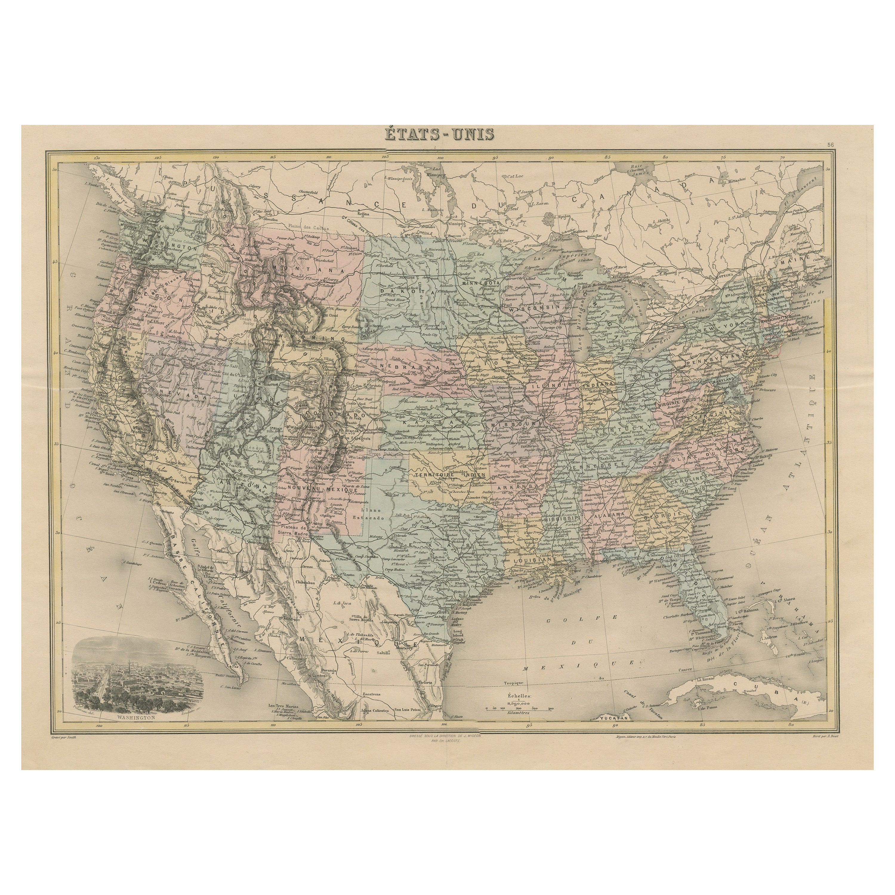
Antique Map of the United States with Vignette of Washington
Located in Langweer, NL
Antique map titled 'États-Unis'. A very attractive and detailed late 19th century map of the United States, with a fine decorative vignette of Washington. The extensive railway netwo...
Category
Antique Late 19th Century Maps
Materials
Paper
$459 Sale Price
20% Off
Antique Map of the United States by Balbi
1847
Located in Langweer, NL
Antique map titled 'Etats-Unis'. Original antique map of the United States. This map originates from 'Abrégé de Géographie (..)' by Ad...
Category
Antique Mid-19th Century Maps
Materials
Paper

$191 Sale Price
20% Off
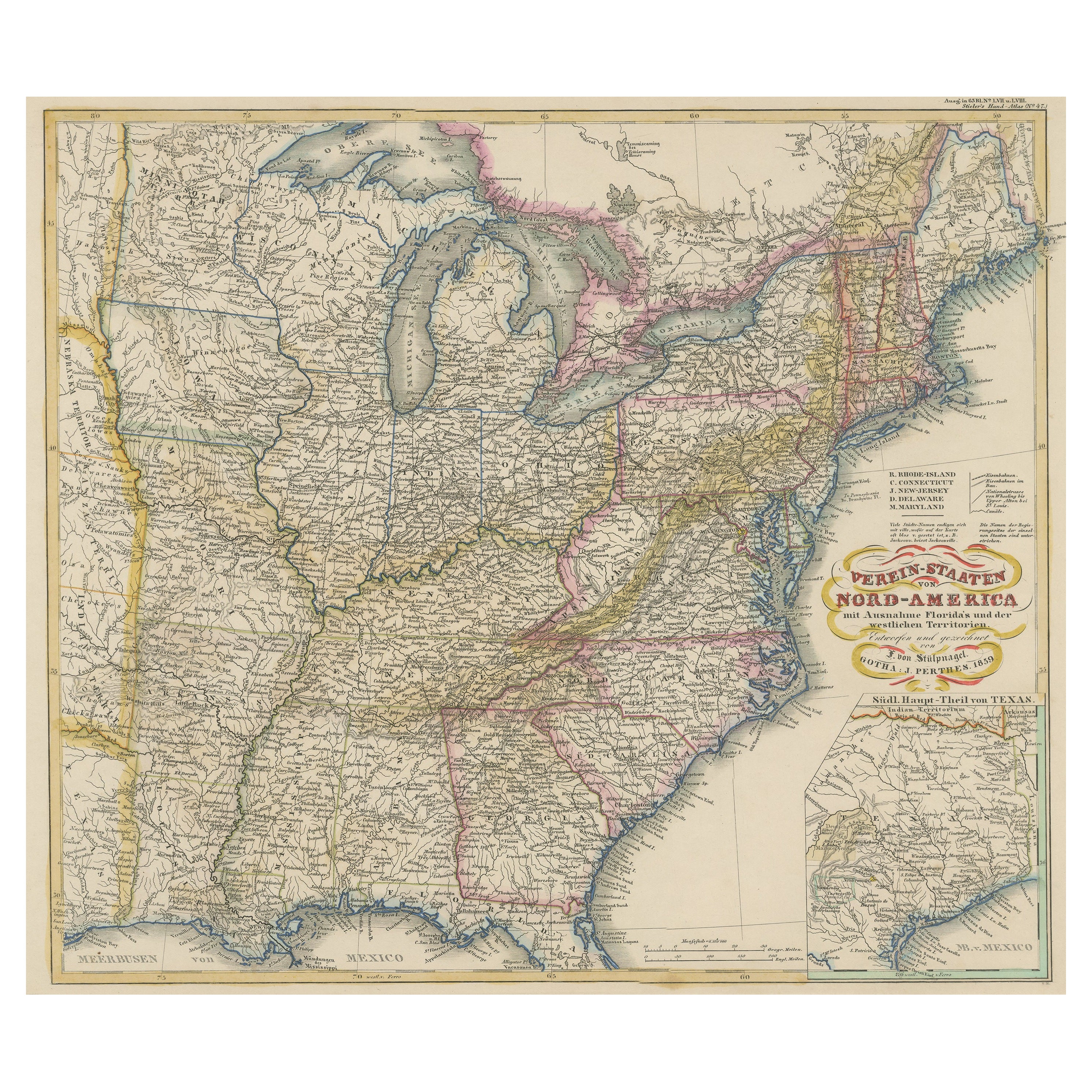
Antique Map of the Eastern United States with Inset Map of Texas
Located in Langweer, NL
Antique map titled 'Verein-Staaten von Nord-America mit Ausnahme Florida's und der Westlichen Territorien'. This map extends as far west as Louisiana and only includes the northern p...
Category
Antique Mid-19th Century Maps
Materials
Paper

$516 Sale Price
20% Off
Antique Map of the Eastern United States by Levasseur
1875
Located in Langweer, NL
Antique map titled 'Carte de la Region orientale des États-Unis et de la dominion du Canada'. Large map of the Eastern United States. This map originates from 'Atlas de Géographie Mo...
Category
Antique Late 19th Century French Maps
Materials
Paper

$287 Sale Price
40% Off
You May Also Like
Original Antique Map of United States, Grattan and Gilbert, 1843
Located in St Annes, Lancashire
Great map of United States
Drawn and engraved by Archer
Published by Grattan and Gilbert. 1843
Original colour
Unframed.
Category
Antique 1840s English Maps
Materials
Paper

1866 "Johnson
s United States" Map, Published by Johnson and Ward
Located in Colorado Springs, CO
Presented is a detailed map of the United States by A. J. Johnson. Spanning the whole of the continental United States, as well as adjacent parts of Canada and Mexico, the map reflec...
Category
Antique 1860s American Victorian Maps
Materials
Paper

Original Antique Map of The United States of America by Dower, circa 1835
Located in St Annes, Lancashire
Nice map of the USA
Drawn and engraved by J.Dower
Published by Orr & Smith. C.1835
Unframed.
Free shipping
Category
Antique 1830s English Maps
Materials
Paper

1856 "Map of the United States" by Ensign, Bridgeman, and Fanning
Located in Colorado Springs, CO
Presented is a scarce American wall map of the United States and Mexico issued by Ensign, Bridgman, and Fanning in 1856. As the title suggests, the map covers all of the United State...
Category
Antique 1850s American Victorian Maps
Materials
Paper

Large Original Antique Map of the United States of America. 1891
By Rand McNally
Co.
Located in St Annes, Lancashire
Fabulous map of The United States
Original color
By Rand, McNally & Co.
Dated 1891
Unframed
Free shipping.
Category
Antique 1890s American Maps
Materials
Paper

1842 Wall Map of the United States by J. H. Young, Published by S. A. Mitchell
Located in Colorado Springs, CO
Presented is an 1842 hanging “Map of the United States,” engraved by J. H. Young and published by Samuel Augustus Mitchell, Philadelphia. This is a beautiful example of the rare 1842...
Category
Antique 1840s American Maps
Materials
Paper

More Ways To Browse
Antique Rogers
Portrait George Washington
Americana Antiques
Portrait Of George Washington
Blue Green Wool And Silk Rug
Brown Sheepskin Chair
Vintage Brass Bar Carts
Antique Botanical Prints
Green Persian Rug
50 X 50 Coffee Table
Milo Baughman 1970
Spanish Baroque Furniture
Stone China
Couch Console
Vintage Burn
Chinese Stone
Sterling Silver Flatware Service For 12
Antique Dining Tables With Leaves