Items Similar to Orographic Map of the Philippine Islands – Observatorio de Manila, 1899
Want more images or videos?
Request additional images or videos from the seller
1 of 10
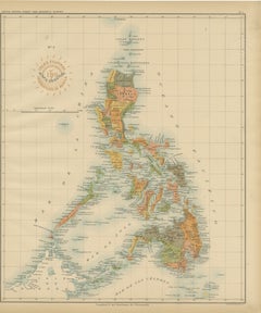
Orographic Map of the Philippine Islands – Observatorio de Manila, 1899
$556.43
£407.34
€460
CA$761.25
A$804.83
CHF 432.50
MX$9,666.18
NOK 5,415.61
SEK 4,955.69
DKK 3,503.89
About the Item
Title: Orographic Map of the Philippine Islands – Observatorio de Manila, 1899
This finely executed chromolithographed map, titled “Islas Filipinas – Mapa Orográfico,” was created in 1899 under the direction of Rev. José Algué, S.J., Director of the Observatorio de Manila. Issued as Plate No. 4 from the Atlas de Filipinas, this map was part of a landmark project produced by Filipino draftsmen under Jesuit supervision and later published by the U.S. Coast and Geodetic Survey in Washington (1900).
The map presents an orographic (topographic) view of the Philippine Archipelago, illustrating the country’s mountain systems, elevations, and reliefs with shaded contour lines. It distinguishes the archipelago’s principal highland and lowland zones through color gradations—ranging from the mountain chains of northern Luzon and Mindanao to the coastal plains and valleys of the Visayas. The “Signos” legend in the lower left identifies elevation categories, from 0–200 meters to over 2,000 meters above sea level.
Printed with meticulous clarity and refined coloring, the map integrates both scientific accuracy and aesthetic appeal. It bears two official markings: the red ink stamp of the “Observatorio de Manila” and the embossed seal of the “U.S. Coast and Geodetic Survey,” confirming its authenticity and dual publication during the pivotal shift from Spanish to American administration.
This orographic map stands as an early example of modern topographic mapping in the Philippines and reflects the pioneering scientific work of Jesuit cartographers in collaboration with American geographers. It not only documents the natural landscape but also symbolizes the Philippines’ transition into a new era of scientific cartography.
Condition: Excellent, with original color, very light toning, and wide margins. Both embossed and inked official seals clearly visible.
Framing tips: Best displayed in a light or walnut wood frame with a soft beige or cream mat to accentuate the subtle blue and tan shading of the topography.
Technique: Chromolithograph on paper
Maker: Rev. José Algué, S.J., Observatorio de Manila, 1899
- Dimensions:Height: 14.57 in (37 cm)Width: 12.8 in (32.5 cm)Depth: 0.01 in (0.2 mm)
- Materials and Techniques:
- Place of Origin:
- Period:
- Date of Manufacture:1899
- Condition:Condition: Excellent, with original color, very light toning, and wide margins. Both embossed and inked official seals clearly visible.
- Seller Location:Langweer, NL
- Reference Number:Seller: BG-12176-41stDibs: LU3054346957162
About the Seller
5.0
Recognized Seller
These prestigious sellers are industry leaders and represent the highest echelon for item quality and design.
Platinum Seller
Premium sellers with a 4.7+ rating and 24-hour response times
Established in 2009
1stDibs seller since 2017
2,854 sales on 1stDibs
Typical response time: 1 hour
- ShippingRetrieving quote...Shipping from: Langweer, Netherlands
- Return Policy
More From This Seller
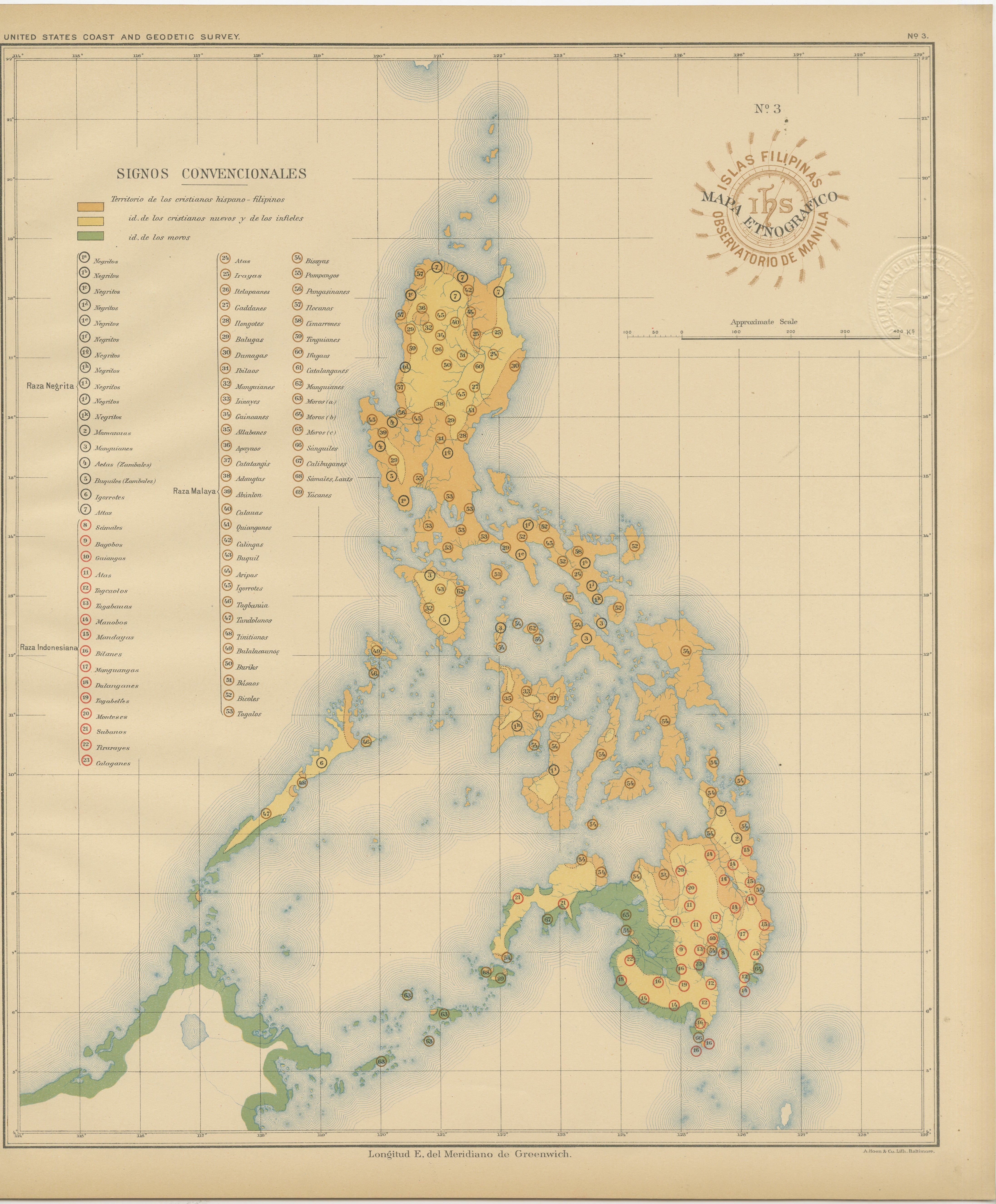
View AllEthnographic Map of the Philippine Islands – Observatorio de Manila, 1899
Located in Langweer, NL
Ethnographic Map of the Philippine Islands – Observatorio de Manila, 1899
This rare and fascinating chromolithographed map titled “Islas Filipinas – Mapa Etnográfico” was created in...
Category
Antique 1890s Philippine Maps
Materials
Paper
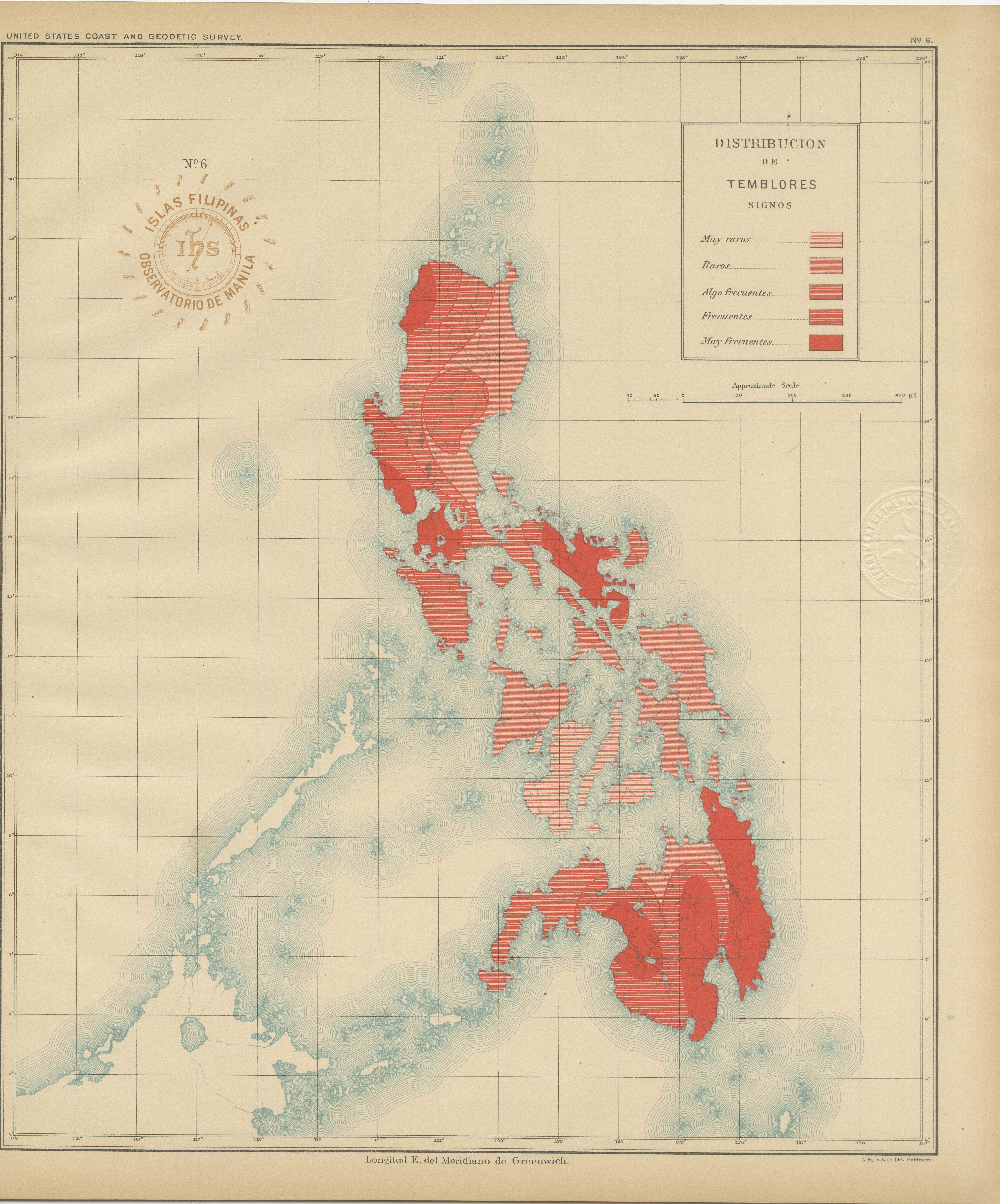
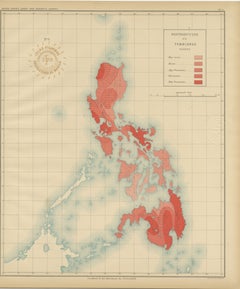
Seismic Activity Map of the Philippine Islands – Observatorio de Manila, 1899
Located in Langweer, NL
Title: Seismic Activity Map of the Philippine Islands – Observatorio de Manila, 1899
This striking chromolithograph titled “Distribución de los Temblores” (Distribution of Earthquak...
Category
Antique 1890s Philippine Maps
Materials
Paper
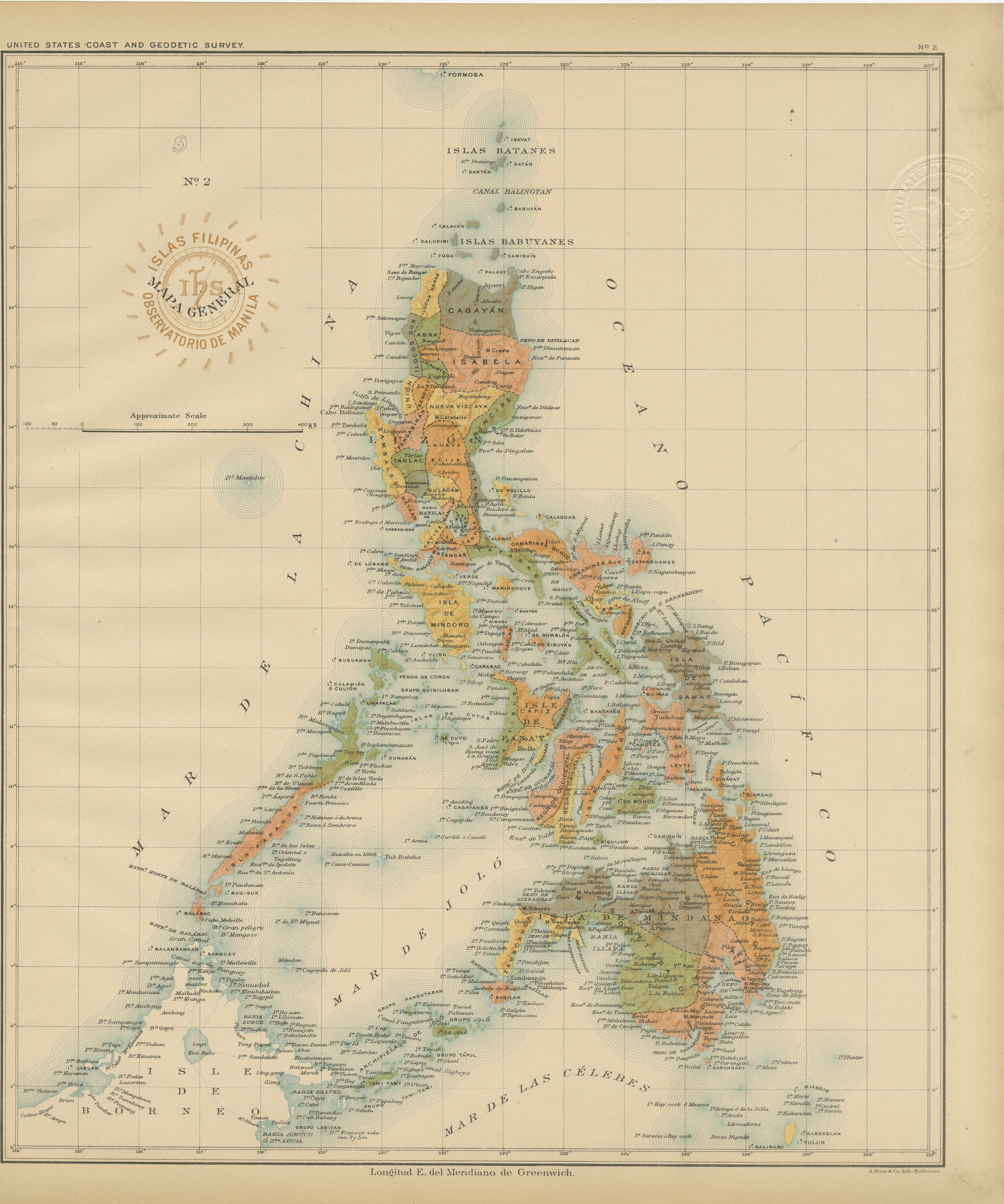
Antique Map of the Philippine Islands – Observatorio de Manila, 1899
Located in Langweer, NL
Antique Map of the Philippine Islands – Observatorio de Manila, 1899
This beautiful chromolithographed map titled “Islas Filipinas” was created in 1899 under the direction of Rev. J...
Category
Antique 1890s Philippine Maps
Materials
Paper
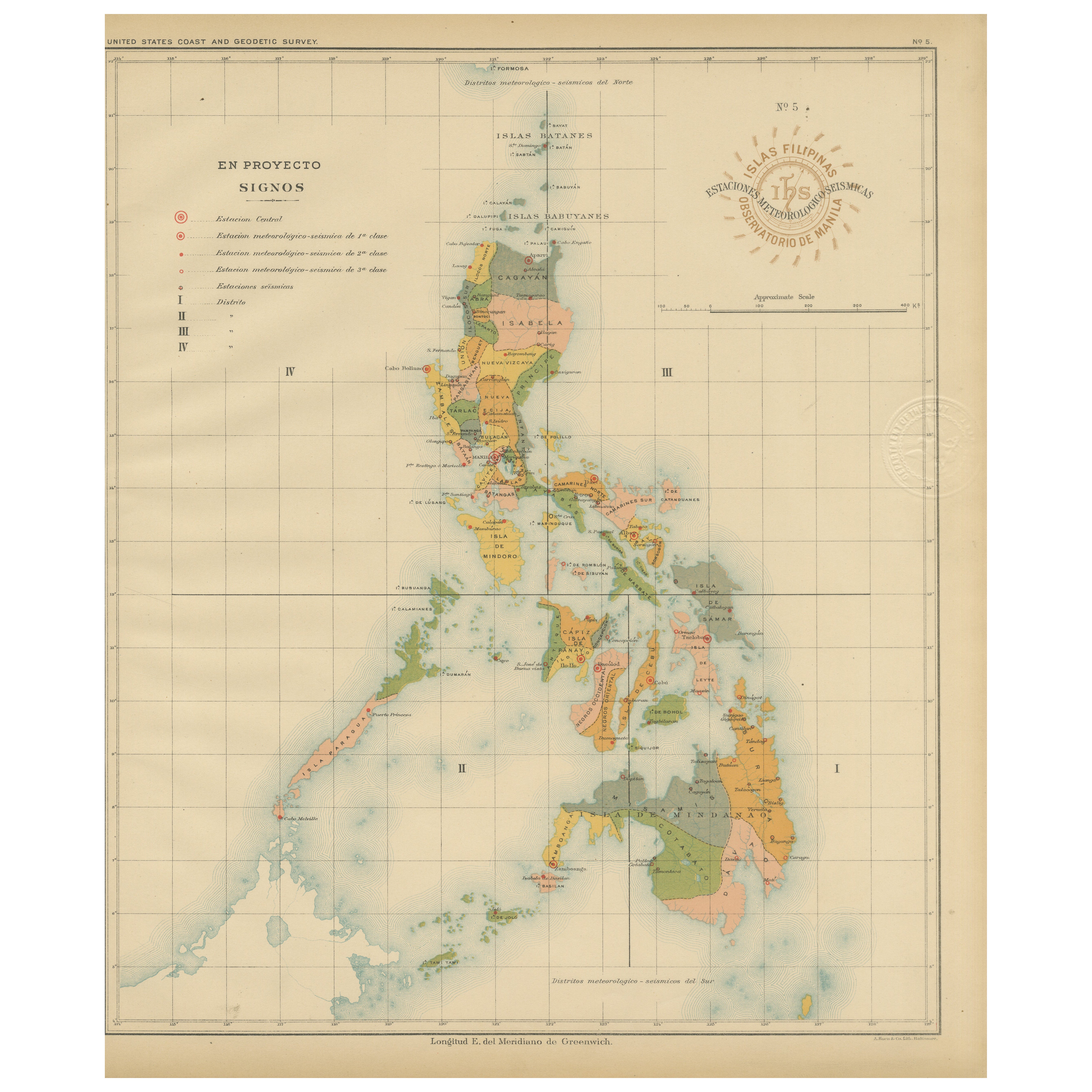
Philippine Meteorological
Seismological Network Map – Manila Observatory, 1899
Located in Langweer, NL
Title: Meteorological and Seismological Stations of the Philippines – Observatorio de Manila, 1899
This rare scientific chromolithograph titled “Islas Filipinas – Estaciones Meteoro...
Category
Antique 1890s Philippine Maps
Materials
Paper

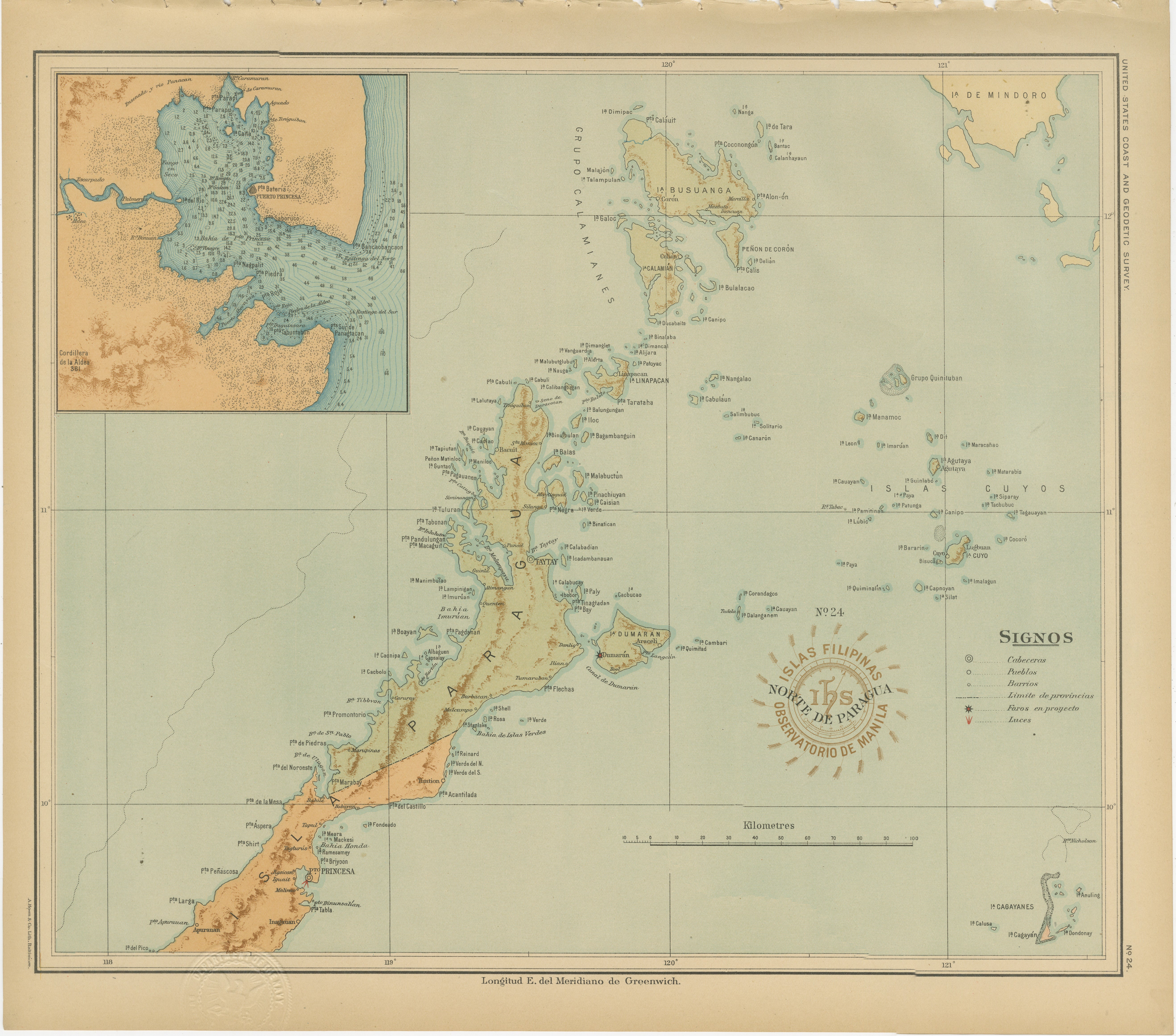
Map of the Northern Part of Palawan – Observatorio de Manila, 1899
Located in Langweer, NL
Title: Map of the Northern Part of Palawan – Observatorio de Manila, 1899
This finely detailed chromolithograph titled “Islas Filipinas – Norte de Paragua” depicts the northern regi...
Category
Antique 1890s Philippine Maps
Materials
Paper
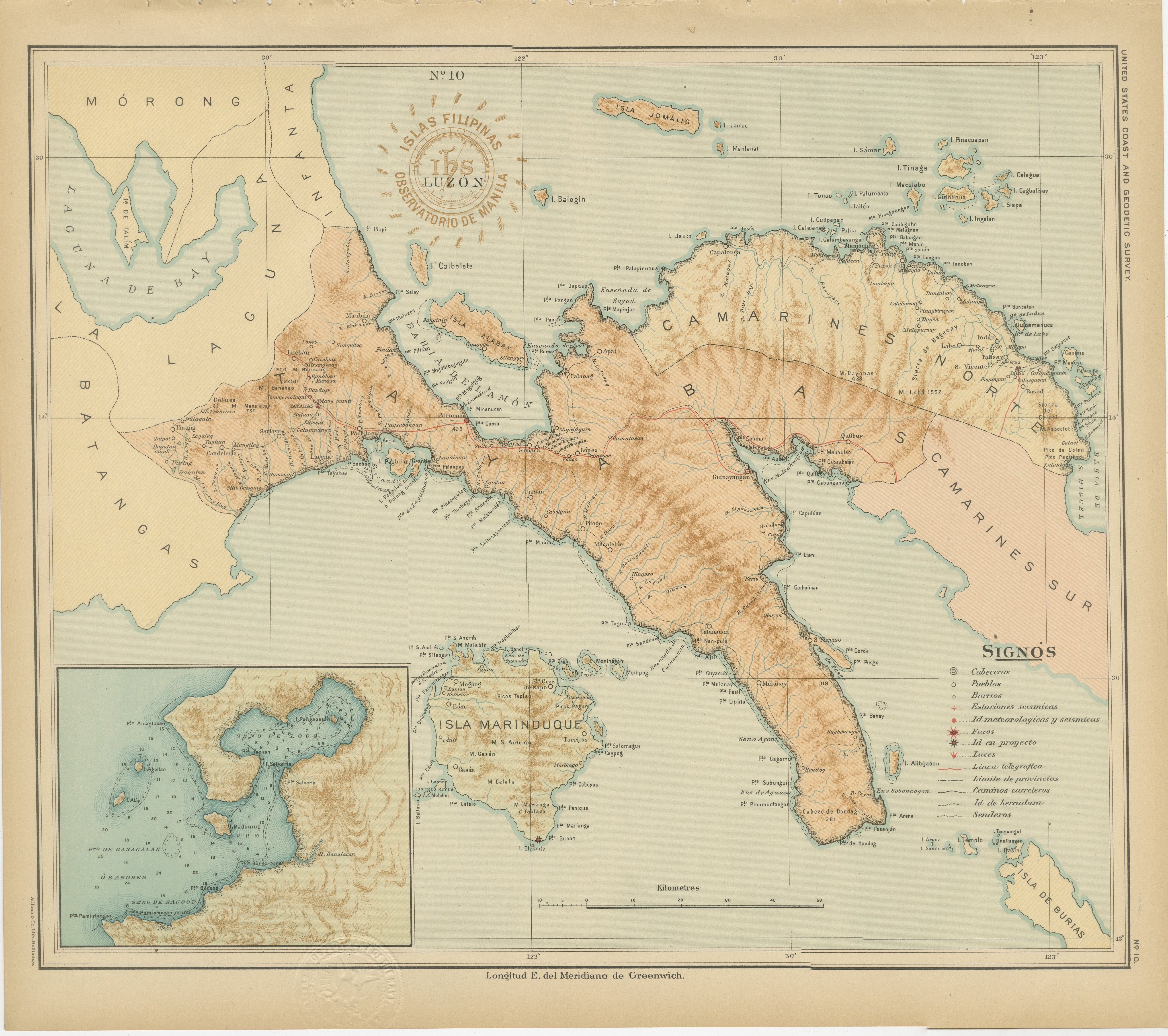
Map of Southern Luzon and Camarines Provinces – Observatorio de Manila, 1899
Located in Langweer, NL
Title: Map of Southern Luzon and Camarines Provinces – Observatorio de Manila, 1899
Description:
This chromolithographed map titled “Islas Filipinas – Luzón” was published in 1899 u...
Category
Antique 1890s Philippine Maps
Materials
Paper
You May Also Like
Original Antique Map of The Philippines. C.1900
Located in St Annes, Lancashire
Fabulous map of The Philippines
Original color.
Engraved and printed by the George F. Cram Company, Indianapolis.
Published, C.1900.
Unframed.
Free shipping.
Category
Antique 1890s American Maps
Materials
Paper

Original Antique Map of US Possessions In The Pacific Ocean, C.1900
Located in St Annes, Lancashire
Fabulous map of US possessions in the Pacific Ocean
Original color.
Engraved and printed by the George F. Cram Company, Indianapolis.
Published, C.1900.
Unframed.
Free shipping.
Category
Antique 1890s American Maps
Materials
Paper

Original Antique Map of South East Asia by Thomas Clerk, 1817
Located in St Annes, Lancashire
Great map of South East Asia
Copper-plate engraving
Drawn and engraved by Thomas Clerk, Edinburgh.
Published by Mackenzie And Dent, 1817
Unframed.
Category
Antique 1810s English Maps
Materials
Paper

Large Original Vintage Map of British Island Possessions, circa 1920
Located in St Annes, Lancashire
Great map of British Island Possessions
Original color. Good condition
Published by Alexander Gross
Unframed.
Category
Vintage 1920s English Maps
Materials
Paper

Large Original Antique Map of The Pacific Ocean, Fullarton, C.1870
Located in St Annes, Lancashire
Great map of The Pacific Ocean
From the celebrated Royal Illustrated Atlas
Lithograph by Swanston. Original color.
Published by Fullarton,...
Category
Antique 1870s Scottish Maps
Materials
Paper

Large Original Vintage Map of S.E Asia, with a Vignette of Singapore
Located in St Annes, Lancashire
Great map of South East Asia
Original color. Good condition
Published by Alexander Gross
Unframed.
Category
Vintage 1920s English Maps
Materials
Paper
