Items Similar to Ottoman Empire in Europe – Antique Map by Reilly, Vienna, 1796

Video Loading
Want more images or videos?
Request additional images or videos from the seller
1 of 13
Ottoman Empire in Europe – Antique Map by Reilly, Vienna, 1796
$1,751.94
£1,298.30
€1,460
CA$2,394.39
A$2,606.48
CHF 1,383.52
MX$31,361.62
NOK 17,531.12
SEK� 16,063.46
DKK 11,121.26
About the Item
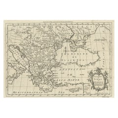
Map of the Ottoman Empire in Europe – Reilly, Vienna circa 1794-1796
This large original antique map, titled “Karte von dem Oschmanischen Reiche in Europa,” was published between 1794 and 1796 by Franz Johann Joseph von Reilly in Vienna. It is from his monumental “Grosser Deutscher Atlas,” Plate 22, and is based on the works of D’Anville, Schmidt, and Santini, notable cartographers of the 18th century.
The map presents the European territories of the Ottoman Empire with remarkable precision for its time, covering the Balkans, Greece, Albania, Macedonia, Bulgaria, Romania, European Turkey, and parts of Hungary and Austria. Place names are in German, with regional boundaries delicately hand-coloured in outline. It features major cities, towns, rivers, and mountain ranges. The Adriatic Sea (Das Adriatische Meer), Black Sea (Das Schwarze Meer oder Pontus Euxinus), and Mediterranean Sea (Das Mittelländische Meer) are clearly labelled.
The cartouche is designed as a curled scroll motif to the left, noting its sources from D’Anville, Schmidt, and Santini, while an explanation of symbols and scales appears above. Franz Johann Joseph von Reilly (1766–1820) was an influential Austrian publisher and writer who issued numerous atlases and geographical works between 1790 and 1800 from Vienna, contributing greatly to European cartography in the late 18th century.
Condition:
Very good condition considering its age. Engraving remains crisp with clear original hand colouring. Minor toning, faint foxing spots mostly to outer margins, and original vertical fold as issued. Edges with only minimal wear, making it highly suitable for framing or archival collection.
Framing tips:
This impressive map deserves a museum-style presentation. A dark mahogany or black frame with archival ivory or off-white matting will highlight the fine engraving and subtle colouring. Its historical and decorative impact is ideal for offices, libraries, studies, or gallery walls focusing on Ottoman history, Balkan studies, or European cartographic collections.
This is a rare opportunity to acquire a genuine late 18th-century map by von Reilly, representing a significant period in geopolitical and cartographic history.
- Dimensions:Height: 25.01 in (63.5 cm)Width: 32.29 in (82 cm)Depth: 0.01 in (0.2 mm)
- Materials and Techniques:Paper,Engraved
- Place of Origin:
- Period:
- Date of Manufacture:1796
- Condition:Very good condition considering its age. Engraving remains crisp with clear original hand colouring. Minor toning, faint foxing spots mostly to outer margins, and original vertical fold as issued. Edges with only minimal wear. Ready to be framed.
- Seller Location:Langweer, NL
- Reference Number:Seller: BG-136561stDibs: LU3054345659562
About the Seller
5.0
Recognized Seller
These prestigious sellers are industry leaders and represent the highest echelon for item quality and design.
Platinum Seller
Premium sellers with a 4.7+ rating and 24-hour response times
Established in 2009
1stDibs seller since 2017
2,816 sales on 1stDibs
Typical response time: 1 hour
- ShippingRetrieving quote...Shipping from: Langweer, Netherlands
- Return Policy
More From This Seller
View AllMap of Turkish Dominions in Europe, Ottoman Balkan Territories 1813
Located in Langweer, NL
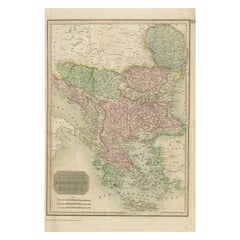
Map of Turkish Dominions in Europe, Ottoman Balkan Territories 1814
This antique map titled "Turkish Dominions in Europe" provides a detailed depiction of the Balkan Peninsula and a...
Category
Antique 1810s Maps
Materials
Paper
18th-Century Map of the Eastern Roman Empire by Henri Chatelain, c. 1719
Located in Langweer, NL
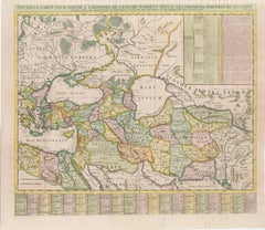
Title: 18th-Century Map of the Eastern Roman Empire by Henri Chatelain, c. 1719
Description: This intricately detailed map, titled *Nouvelle Carte pour Servir à l'Histoire de l'Empi...
Category
Antique 1710s Maps
Materials
Paper
Greece and Ottoman Balkans Map – Homann Engraving ca. 1720
Located in Langweer, NL
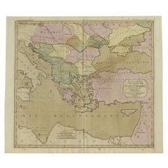
Greece and the Danube Basin Map c.1720 – Antique Engraving of the Balkans
This remarkable early 18th-century map presents a sweeping view of southeastern Europe, centering on the co...
Category
Antique 18th Century German Maps
Materials
Paper

Antique Map of Turkey in Europe, c.1780
Located in Langweer, NL
Antique map titled 'Bowles's new pocket map of Turky in Europe divided into its Provinces'. Large map of Turkey in Europe. Source unknown, to be determined.
Artists and Engravers: Made by 'Thomas & Carington Bowles' after an anonymous artist. Thomas Bowles, born around 1712, was map publisher and seller in London...
Category
Antique 18th Century British Maps
Materials
Paper
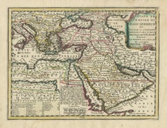
Ottoman Empire Map 1719 – Europe Asia Africa, Jean Chiquet, Paris
Located in Langweer, NL
Title: Ottoman Empire Map 1719 – Europe Asia Africa, Jean Chiquet, Paris
Description:
Original early-18th-century engraved map titled Estats de l’Empire du Grand Seigneur, depicting...
Category
Antique Early 18th Century French Maps
Materials
Paper
Map of the Ottoman Empire in Europe, incl. the Balkans, Greece
Turkey, c.1760
Located in Langweer, NL
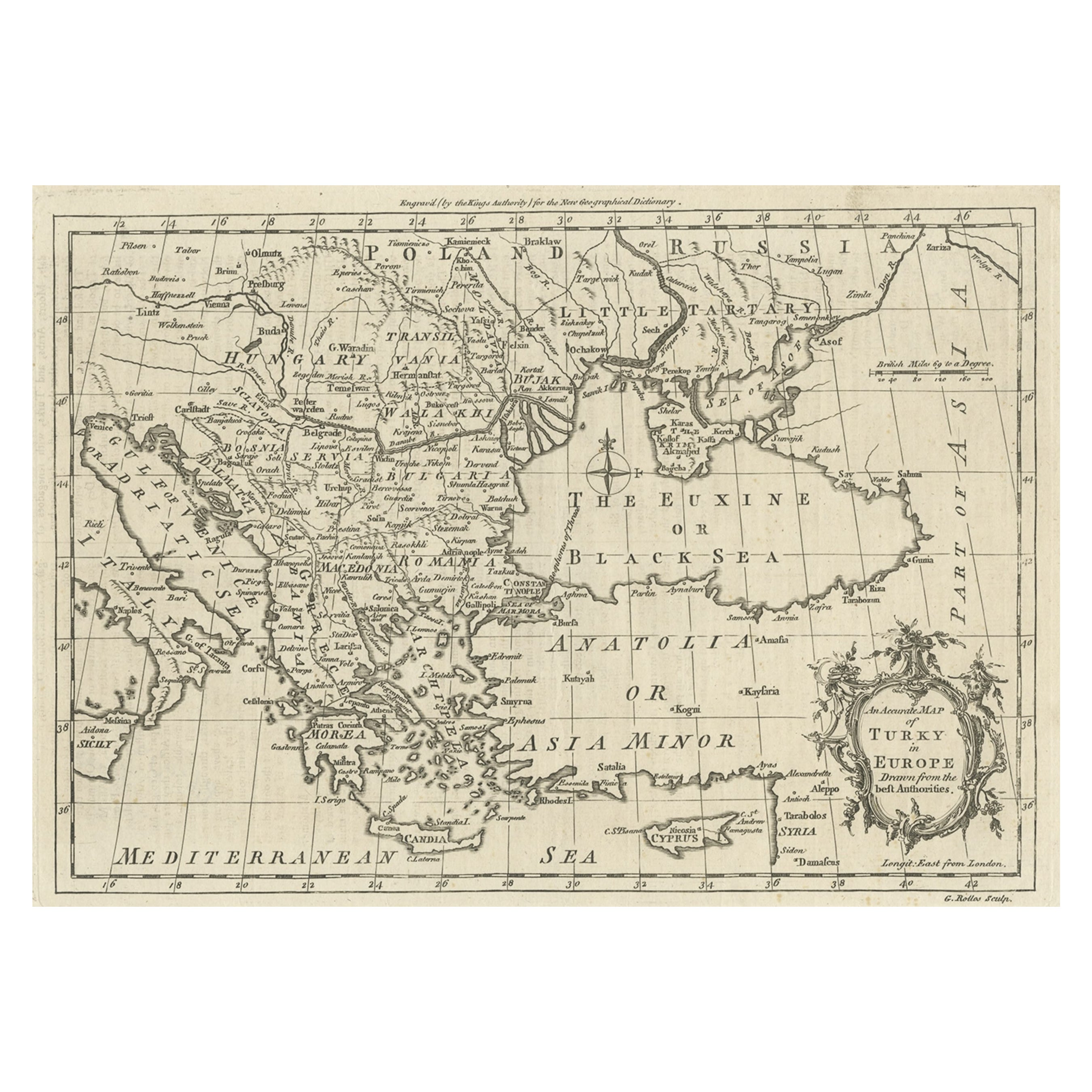
Antique map Turkey titled 'An Accurate Map of Turky in Europe drawn from the best Authorities'.
Map of the Ottoman Empire in Europe, the Balkans, Greece, and Turkey in Europe. Engr...
Category
Antique 1760s Maps
Materials
Paper
$441 Sale Price
20% Off
You May Also Like
Hand-Colored 18th Century Homann Map of the Danube, Italy, Greece, Croatia
By Johann Baptist Homann
Located in Alamo, CA
"Fluviorum in Europa principis Danubii" is a hand colored map of the region about the Danube river created by Johann Baptist Homann (1663-1724) in his 'Atlas Novus Terrarum', publish...
Category
Antique Early 18th Century German Maps
Materials
Paper

Hand-Colored 18th Century Homann Map of the Black Sea, Turkey and Asia Minor
By Johann Baptist Homann
Located in Alamo, CA
An attractive original early 18th century hand-colored map of the Black Sea and Turkey entitled "Carte de L'Asie Minevre ou de la Natolie et du Pont Evxin Tiree des Voyages et des Ob...
Category
Antique Early 18th Century German Maps
Materials
Paper

$700 Sale Price
20% Off
Southern
Eastern Europe: A Large 17th C. Hand-colored Map by Sanson
Jaillot
By Nicolas Sanson
Located in Alamo, CA
This large hand-colored map entitled "Estats de L'Empire des Turqs en Europe, ou sont les Beglerbeglicz our Gouvernements" was originally created by Nicholas Sanson d'Abbeville and t...
Category
Antique 1690s French Maps
Materials
Paper

$1,740 Sale Price
20% Off
1790 Thomas Stackhouse Map, Entitled "Russia in Europe, " , Ric.a004
Located in Norton, MA
1790 Thomas Stackhouse map, entitled
"Russia in Europe"
Ric.a004
Stackhouse, Thomas
Russia in Europe [map]
London: T. Stackhouse, 1783. Map. Matted hand-colored copper engraving. Image size: 14.5 x 15.25 inches. Mat size: 22.75 x 23.75 inches. A beautiful example of this map of Eastern Europe...
Category
Antique 17th Century Unknown Maps
Materials
Paper

Danube River, Italy, Greece and Croatia: A Hand-colored 18th C. Homann Map
By Johann Baptist Homann
Located in Alamo, CA
"Fluviorum in Europa principis Danubii" is a hand-colored map of the region about the Danube river created by Johann Baptist Homann (1663-1724) in his 'Atlas Novus Terrarum', publish...
Category
Early 18th Century Old Masters Landscape Prints
Materials
Engraving

18th Century Map of the Southern Balkans by Giovanni Maria Cassini
By Giovanni Maria Cassini
Located in Hamilton, Ontario
18th century map by Italian engraver Giovanni Maria Cassini (Italy 1745-1824).
Map of the Southern Balkans: Rome. Hand colored and copper engraved print done in the year 1788. It in...
Category
Antique 18th Century Italian Maps
Materials
Paper

$795 Sale Price
36% Off
More Ways To Browse
Antique Romanian
Franz Joseph
Vienna 18th
Empire Vienna
Antique Victorian Dining Tables
Italian Plastic Chairs
Black Crystal Glasses
French Mid Century Modern Rug
China Silk Rug
Chrome Glass Coffee Tables
Antique Italian Chairs
Antique Walnut Bar
Beni Ourain Rugs
French Iron And Glass Table
Glass Top Wood Base Coffee Tables
T Chair
Antique Silver Basket
Antique Walkers