Items Similar to Ottoman Empire Map 1719 – Europe Asia Africa, Jean Chiquet, Paris

Want more images or videos?
Request additional images or videos from the seller
1 of 9
Ottoman Empire Map 1719 – Europe Asia Africa, Jean Chiquet, Paris
$561.50
£419.63
€470
CA$774.61
A$848.44
CHF 446.70
MX$10,125.87
NOK 5,692.85
SEK 5,204.12
DKK 3,582.41
About the Item
Title: Ottoman Empire Map 1719 – Europe Asia Africa, Jean Chiquet, Paris
Description:
Original early-18th-century engraved map titled Estats de l’Empire du Grand Seigneur, depicting the Ottoman Empire across three continents: Europe, Asia, and Africa. This example is clearly dated 1719 in the engraved cartouche and bears the publisher’s imprint Chez Jacq. Chiquet à Paris 1719.
The map presents the Ottoman Empire at an early Enlightenment moment, extending from Central and Southeastern Europe through Anatolia and the Levant, across Mesopotamia and Arabia, and into Egypt and the North African Barbary Coast. Political regions are defined by engraved boundaries and differentiated with original hand coloring, while coastlines, rivers, and seas are rendered with strong copper engraving typical of early 18th-century French map production.
French toponymy is dense and legible, with major cities and regions clearly identified, including Constantinople, Aleppo, Damascus, Baghdad, Cairo, Mecca, and Jerusalem. The Mediterranean, Black Sea, Red Sea, and Caspian Sea anchor the composition and emphasize the empire’s strategic maritime reach.
The decorative cartouche at upper right contains the full title and date, identifying the Ottoman ruler as “Grand Seigneur,” Sultan and Emperor of the Turks, ruling territories in Europe, Asia, and Africa. A lower table listing Ottoman rulers reinforces the political and didactic purpose of the map, which was intended both for geographic reference and informed private collecting.
Issued by Jean Chiquet, a Parisian map seller active in the early 18th century, this map reflects the commercial dissemination of authoritative geographic models during the reign of Louis XV. It combines political clarity with restrained decorative appeal, making it equally suitable for scholarly collections and interior display.
Condition report:
Copper engraving with original hand coloring. Age-related toning and light spotting consistent with an early 18th-century print. Minor edge wear and small handling marks, mainly in the margins. Plate mark visible. No major losses or repairs. Overall very good condition for a map dated 1719.
Framing tips:
Preserve the full margins and visible plate mark with a wide ivory or parchment-toned mat. A walnut, ebonized wood, or muted antique gold frame complements the period character. For a cleaner contemporary look, use a slim black frame with generous off-white matting.
SEO keyword block:
Ottoman Empire map 1719, antique Ottoman map, Jean Chiquet map, Middle East map 18th century, Holy Land map antique, Arabia map 1719, Turkey map antique, Islamic world map, French engraved map, hand colored antique map, Europe Asia Africa map
Technique: Copper engraving with original hand coloring
Maker: Jean Chiquet, Paris, 1719
- Dimensions:Height: 8.12 in (20.6 cm)Width: 10.95 in (27.8 cm)Depth: 0.01 in (0.2 mm)
- Materials and Techniques:Paper,Engraved
- Place of Origin:
- Period:
- Date of Manufacture:1719
- Condition:Copper engraving with original hand coloring. Age-related toning and light spotting consistent with an early 18th-century print. Minor edge wear and small handling marks, mainly in the margins. Plate mark visible. No major losses or repairs.
- Seller Location:Langweer, NL
- Reference Number:Seller: BG-141971stDibs: LU3054348065702
About the Seller
5.0
Recognized Seller
These prestigious sellers are industry leaders and represent the highest echelon for item quality and design.
Platinum Seller
Premium sellers with a 4.7+ rating and 24-hour response times
Established in 2009
1stDibs seller since 2017
2,806 sales on 1stDibs
Typical response time: 1 hour
- ShippingRetrieving quote...Shipping from: Langweer, Netherlands
- Return Policy
More From This Seller
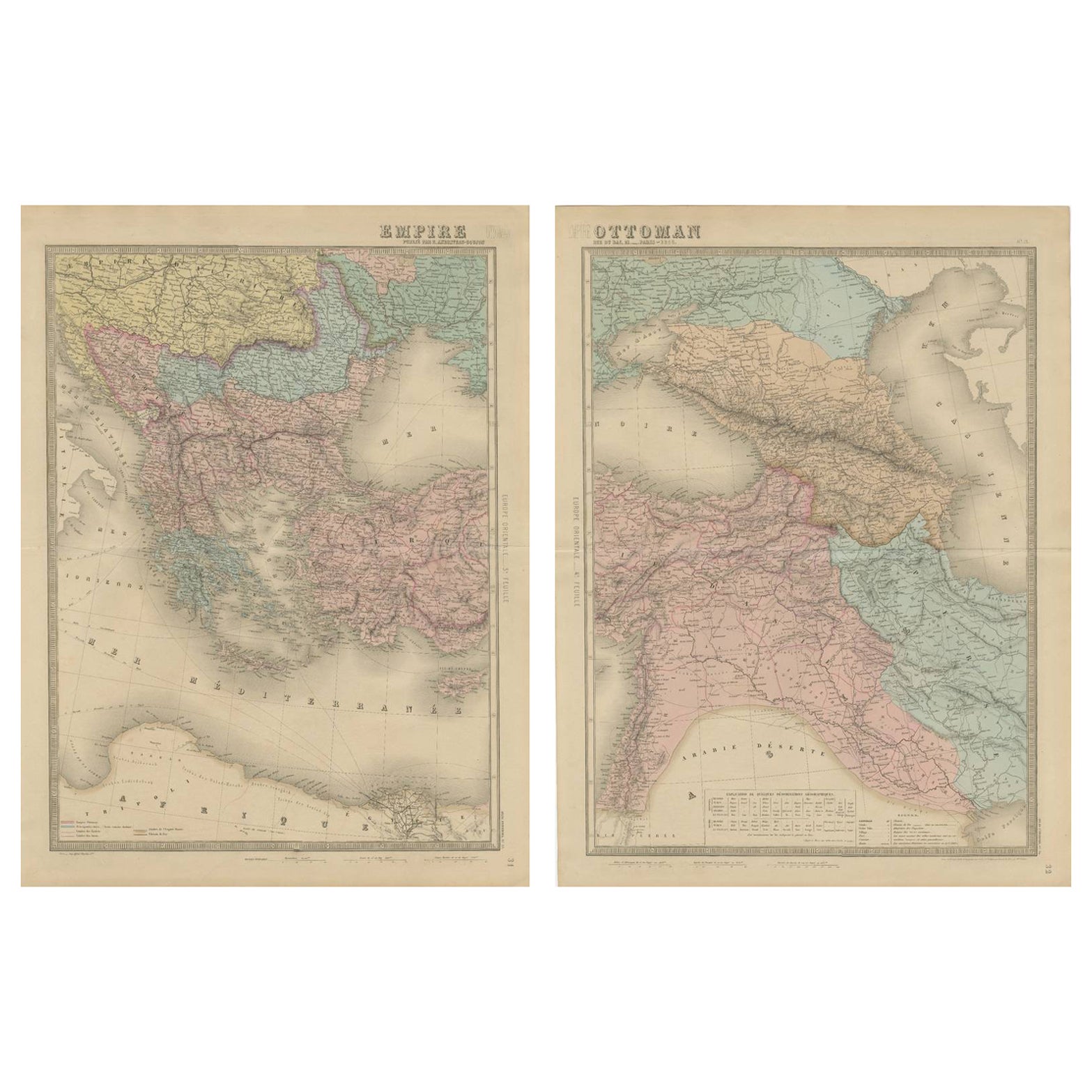
View AllLarge Antique Set Ottoman Empire Maps – Europe
Asia in Striking Detail, 1868
Located in Langweer, NL
Antique Maps of the Ottoman Empire – Europe and Asia by Andriveau-Goujon, circa 1865
This finely engraved and hand-colored two-sheet map of the Ottoman Empire was published in Paris...
Category
Antique Mid-19th Century French Maps
Materials
Paper
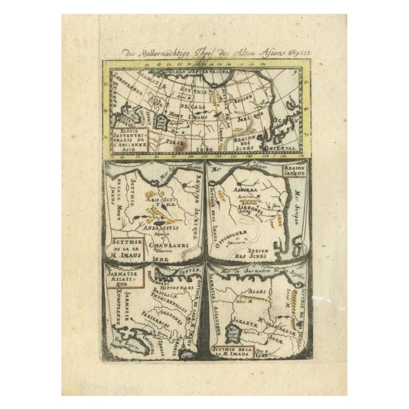
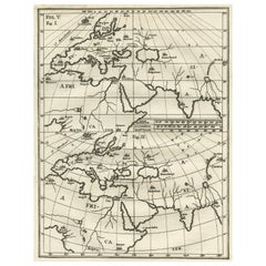
Antique Map of Northern Asia by Mallet, 1719
Located in Langweer, NL
Antique map titled 'Das Mitternächtige Theil des Alten Asien'. This sheet of five miniature maps describes the northern part of Asia in classical times, perhaps circa 150 AD. At the top, an overview map shows the main regions and territories, which are pictured in more detail below. From left to right, the four maps below depict Scythia east of the Imaus (Pamir) Mountains, Serica, Sychia west of the Pamir mountains, and Sarmatia, the last of which borders the Black Sea. Originates from Alain Manesson Mallet's 'Description de l 'Univers' (German edition). Artists and Engravers: Alain Manesson Mallet (1630-1706) was a French cartographer and engineer. He started his career as a soldier in the army of Louis XIV, became a Sergeant-Major in the artillery and an Inspector of Fortifications. He also served under the King of Portugal, before returning to France, and his appointment to the court of Louis XIV. His military engineering and mathematical background led to his position teaching mathematics at court. His major publications were Description de L'Univers (1683) in 5 volumes, and Les Travaux de Mars ou l'Art de la Guerre (1684) in 3 volumes. His Description de L'Universe contains a wide variety of information, including star maps...
Category
Antique 18th Century Maps
Materials
Paper
$92 Sale Price
20% Off
Antique Map of Europe Stretching from Northern Africa to the Baltic Sea, 1719
Located in Langweer, NL
Antique map titled 'Carte de la Germanie et les diferents Etats ou ses Peuples ont porté leurs conquestes'. Original antique map of Europe stretching from northern Africa to the Balt...
Category
Antique 18th Century Maps
Materials
Paper

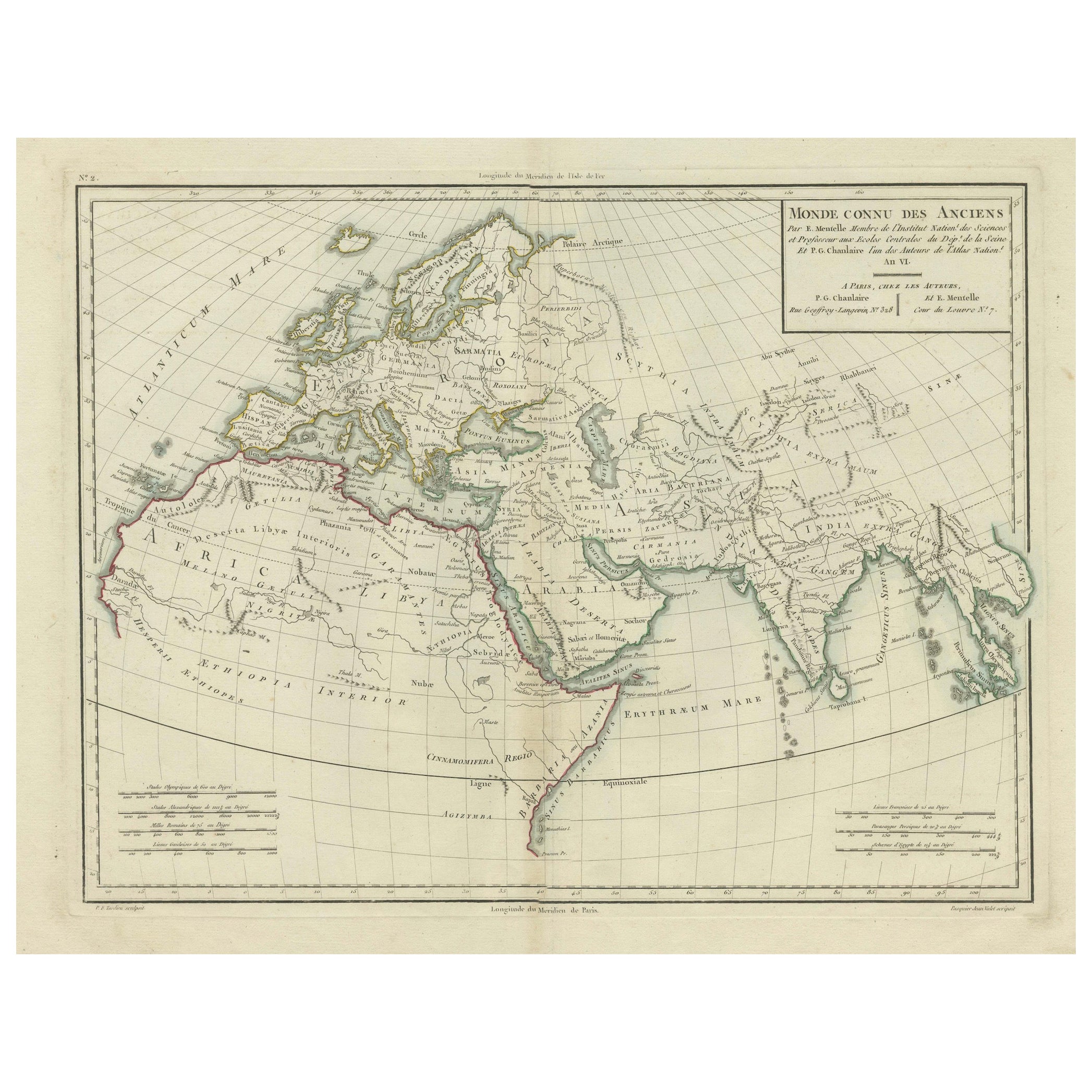
Ancient World Map: Europe, Africa
Asia - 1802 Tardieu Atlas
Located in Langweer, NL
Antique Map Description with title: "Monde Connu Des Anciens"
Publication Details:
- Atlas Title: Nouvel Atlas Universel de Géographie Ancienne et Moderne
- Purpose: For the Nouvel...
Category
Antique Early 1800s Maps
Materials
Paper
$420 Sale Price
20% Off
Intriguing Antique Map of Europe, Asia and Africa by Scherer, c.1703
Located in Langweer, NL
Two maps on a single sheet showing Europe, Asia and Africa, each depicting nearly the same area. On close examination there are slight differences. Major cities are located. Printed ...
Category
Antique 18th Century German Maps
Materials
Paper
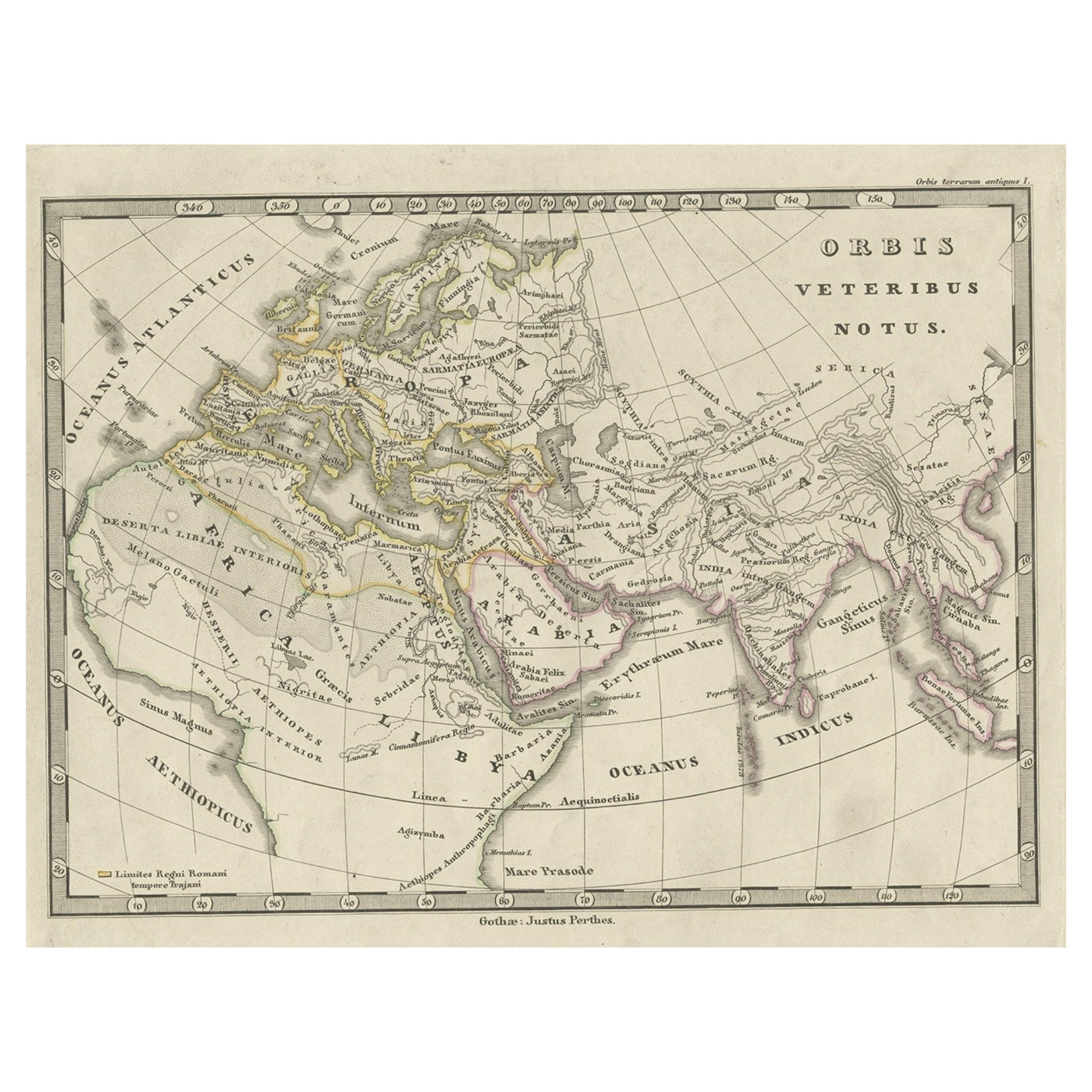
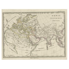
Antique Map of Europe and Part of Asia and Africa, 1848
Located in Langweer, NL
Antique map titled 'Orbis Veteribus Notus'. Old map of the European continent, also depicting a portion of Asia and Africa. Originating from 'Orbis Terrarum Antiquus in usum Scholaru...
Category
Antique 19th Century Maps
Materials
Paper
You May Also Like
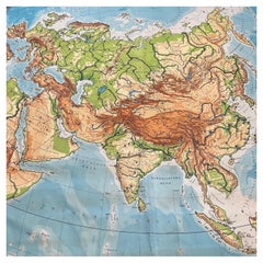
Huge Europe and Asia Vintage Wall Map
Located in San Diego, CA
A huge Europe and Asia vintage wall map, circa 1950s. The map is in fair vintage condition and measures 78"W x 73"H". #2863
Category
Mid-20th Century American Maps
Materials
Paper
$380 Sale Price
20% Off
Large Original Antique Map of Africa. C.1900
Located in St Annes, Lancashire
Fabulous map of Africa
Original color.
Engraved and printed by the George F. Cram Company, Indianapolis.
Published, C.1900.
Unframed.
Free shipping.
Category
Antique 1890s American Maps
Materials
Paper

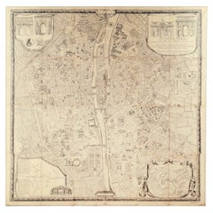
"Plan de Paris" - Antique Recreation of a Map of Paris
Located in New York, NY
Printed in the Early 20th Century, this antique "Plan de Paris" is a recreation of an earlier map from 1710, originally commissioned by Louis XIV. It was an intricately rendered view...
Category
Early 20th Century French Louis XIV Maps
Materials
Linen, Wood, Paper
Original Antique Map of Europe, Arrowsmith, 1820
Located in St Annes, Lancashire
Great map of Europe
Drawn under the direction of Arrowsmith.
Copper-plate engraving.
Published by Longman, Hurst, Rees, Orme and Brown, 1820
...
Category
Antique 1820s English Maps
Materials
Paper

1870 "Johnson
s Europe" Map Published by A. J. Johnson
Located in Colorado Springs, CO
Presented is an original 1870 "Johnson’s Europe" map. First published in 1864, this map was issued as pages 87 and 88 in the 1870 edition of “Johnson's New Illustrated (Steel Plate) ...
Category
Antique 1870s American Victorian Maps
Materials
Paper

1814 Map of "Russian Empire" Ric.r032
Located in Norton, MA
1814 Map of
"Russian Empire"
Ric.r032
Russian Empire. Description: This is an 1814 John Thomson map of the Russian Empire. The map depicts the region from the Baltic Sea, Prussia, and Sweden to the Aleutian Islands and from the Arctic Ocean to the Yellow River. Highly detailed, myriad cities, towns, and villages are labeled throughout, including St. Petersburg, Moscow, Minsk, Kiev, and Kharkov. Rivers and mountain ranges are also identified, as are islands and numerous locations along the coastlines. It is important to note that the long-disputed sea between Korea and Japan is identified as the 'Sea of Japan.
Historical Context:
In 1815, Tsarist Russia emerged from the Napoleonic Wars economically insolvent and politically fearful of the Revolutionary fervor that had just swept through Europe. In order to shore up Russia's economic position, the Tsars began an aggressive series of expansions into the Caucuses and Central Asia that would vastly increase the landmass of the Russian Empire.
Publication History
Thomson maps are known for their stunning color, awe inspiring size, and magnificent detail. Thomson's work, including this map, represents some of the finest cartographic art...
Category
Antique 19th Century Unknown Maps
Materials
Paper
