1 of 4
Paris De 1512-1547 de la Gran Gouache apres le plan Tapisserie
$4,200List Price
About the Item
- Dimensions:Height: 40 in (101.6 cm)Width: 46 in (116.84 cm)
- Place of Origin:
- Period:
- Date of Manufacture:1890 - 1900
- Condition:Excellent overall condition with full margins. Two engraved sheets joined at center with a horizontal centerfold not effecting image.
- Seller Location:Boston, MA
- Reference Number:1stDibs: U110228859375
Authenticity Guarantee
In the unlikely event there’s an issue with an item’s authenticity, contact us within 1 year for a full refund. DetailsMoney-Back Guarantee
If your item is not as described, is damaged in transit, or does not arrive, contact us within 7 days for a full refund. Details24-Hour Cancellation
You have a 24-hour grace period in which to reconsider your purchase, with no questions asked.Vetted Professional Sellers
Our world-class sellers must adhere to strict standards for service and quality, maintaining the integrity of our listings.Price-Match Guarantee
If you find that a seller listed the same item for a lower price elsewhere, we’ll match it.Trusted Global Delivery
Our best-in-class carrier network provides specialized shipping options worldwide, including custom delivery.You May Also Like
Antique Print of Maison Rue de la Faisanderie, Paris by Sellier de Gisors, 1900
Located in Langweer, NL
Antique Print of Maison Rue de la Faisanderie, Paris by Sellier de Gisors, c.1900
Antique architectural print titled "Maison Rue de la Faisanderie, Paris," designed by Mr. Sellier d...
Category
20th Century French Prints
Materials
Paper
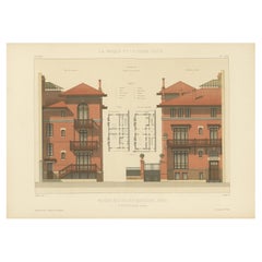
$404
H 12.6 in W 17.72 in D 0.01 in
Antique Sea Chart by J. B. d
Apres de Mannevillette, Sumatra, 1780
Located in Langweer, NL
Antique map titled 'Carte pour aller du Détroit de la Sonde ou de Batavia, au Détroit de Banca'. This uncommon sea chart shows northern Java and eastern Sumatra along with an inset of the small islands in the Detroit Sound. The handsome chart provides detailed navigational information, including the route of Julien Crozet in April 1772, who led a French expedition to the South Pacific after the voyage's commander, Marion De Fresne, and 26 crew members were killed (and allegedly eaten) by a Maori tribe in the Bay of Islands off the coast of New Zealand. With title upper left corner and small inset map of the small isles nearby the south-eastern coast of Sumatra.
J. B. d'Apres de Mannevillette, from his atlas "Neptune orientale". French sailor...
Category
Antique Late 18th Century French Maps
Materials
Paper
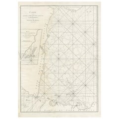
$446 Sale Price
20% Off
H 30.2 in W 20.87 in D 0.02 in
Pavillon de la Grande Tuilerie – French Architectural Lithograph, La Brique
Located in Langweer, NL
Pavillon de la Grande Tuilerie – French Architectural Lithograph, La Brique
This striking antique architectural lithograph shows the pavilion of the Grande Tuilerie de Bourgogne (Mo...
Category
20th Century French Prints
Materials
Paper
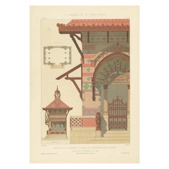
$344
H 17.72 in W 12.6 in D 0 in
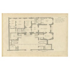
Pl. 8 Antique Plan of the House of Mr. Morel by Le Rouge, c.1785
Located in Langweer, NL
Antique print titled 'Plan de la Maison de Ville et de Campagne de Mr. Morel'. Copper engraving showing a plan of the house of Mr. Morel. This print originates from 'Jardins Anglo-Ch...
Category
Antique 18th Century French Prints
Materials
Paper
Antique Map of Paris, "Carte Routiere des Environs de Paris" 1841
Located in Colorado Springs, CO
This beautiful hand-colored road map of Paris was published in 1841. The map shows Paris and the surrounding area in a folding pocket map. Organized and detailed for travelers, this ...
Category
Antique 1840s French Maps
Materials
Paper

$3,250
H 38.13 in W 47.13 in D 1.25 in
Fort Hollandois De Paliacate Nommé Le Fort De Gueldre, Bellin, 1751
Located in Langweer, NL
Antique print, titled: ?Fort Hollandois de Paliacate nommé le Fort de Gueldre?. Published for Antonine de Prevost d' Exile's Histoire generale des voyages. Artists and Engravers: Jac...
Category
Antique 18th Century Prints
Materials
Paper
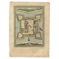
$114 Sale Price
20% Off
H 10.12 in W 7.49 in D 0 in
Pl. 12 Antique Print of an Orangery and Garden Plan by Le Rouge, c.1785
Located in Langweer, NL
Antique print titled 'Jardins de Bessingen (..)'. Copper engraving showing a garden plan and orangery (or orangerie). This print originates from 'Jardins A...
Category
Antique 18th Century Prints
Materials
Paper
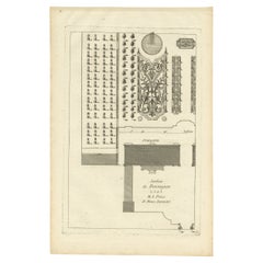
$273
H 16.34 in W 10.63 in D 0 in
Antique Plan of Duin en Berg
the Netherlands
by H. de Leth circa 1732
Located in Langweer, NL
Antique plan titled 'Beschrijving Duin en Berg, de Lustplaets van den Heere Wilhem Hendrik Kerckrinck in Platten Gront'. Decorative cartouche with Dutch and French text. This plan or...
Category
Antique Mid-18th Century Prints
Materials
Paper
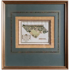
$570
H 18.9 in W 18.12 in D 0.79 in
Géographie des Hébreux – Tableau de la Dispersion des Enfants de Noé, 1837
Located in Langweer, NL
Géographie des Hébreux – Tableau de la Dispersion des Enfants de Noé, 1837
This antique map, titled Géographie des Hébreux ou Tableau de la Dispersion des ...
Category
Antique Mid-19th Century French Maps
Materials
Paper
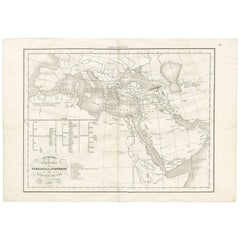
$228 Sale Price
20% Off
H 13.12 in W 19.1 in D 0.02 in
Dutch Map and City Plan of La Roche-sur-Foron, France, 17th Century Hand Colored
By Coenraet Decker
Located in Alamo, CA
"Rupes Allobrogum vulgo La Roche" by Dutch engraver Coenraet Decker (1650-1685) is from the atlas Theatrum Statuum Regiae Celestudinis Sabaudiae Ducis, published in 1682. This richly...
Category
Antique Late 17th Century Dutch Maps
Materials
Paper

$1,675
H 27.75 in W 32.5 in D 0.07 in