Want more images or videos?
Request additional images or videos from the seller
1 of 10
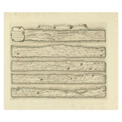
Pattisons
Cycling Maps
$53.29List Price
About the Item
- Dimensions:Height: 3.55 in (9 cm)Width: 2.37 in (6 cm)Depth: 0.04 in (1 mm)
- Place of Origin:
- Period:1900-1909
- Date of Manufacture:1900
- Condition:
- Seller Location:Oxfordshire, GB
- Reference Number:Seller: 268641stDibs: LU97578850723
About the Seller
5.0
Gold Seller
Premium sellers maintaining a 4.3+ rating and 24-hour response times
Established in 1977
1stDibs seller since 2013
835 sales on 1stDibs
Typical response time: 2 hours
Associations
LAPADA - The Association of Arts
Antiques Dealers
Authenticity Guarantee
In the unlikely event there’s an issue with an item’s authenticity, contact us within 1 year for a full refund. DetailsMoney-Back Guarantee
If your item is not as described, is damaged in transit, or does not arrive, contact us within 7 days for a full refund. Details24-Hour Cancellation
You have a 24-hour grace period in which to reconsider your purchase, with no questions asked.Vetted Professional Sellers
Our world-class sellers must adhere to strict standards for service and quality, maintaining the integrity of our listings.Price-Match Guarantee
If you find that a seller listed the same item for a lower price elsewhere, we’ll match it.Trusted Global Delivery
Our best-in-class carrier network provides specialized shipping options worldwide, including custom delivery.You May Also Like
Map Sussex
Located in BUNGAY, SUFFOLK
Map of Sussex with explanation
Maker unknown.
Category
Antique 19th Century English Victorian Maps
Materials
Paper

Antique Map Made After a Roman Papyrus Travel Map, Known as Peutinger Map, 1773
Located in Langweer, NL
Old Dutch engraving with title: 'Romeinsche Reis Kaart van K. Peutinger'.
Rare antique map based on the original 'Peutinger' map, the map has the shape of papyrus scrolls. Originat...
Category
Antique 18th Century Maps
Materials
Paper
$427 Sale Price
20% Off
H 15.56 in W 18.51 in D 0 in
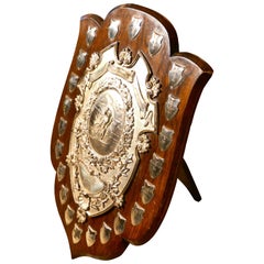
Huge Silchester Cycling Club Track Championships Shield Trophy
Located in Godshill, Isle of Wight
Huge Silchester Cycling Club Track Championships shield trophy
This is a large piece, the oak shield has an embossed silver plated mount, in the centr...
Category
Mid-20th Century International Style Sports Equipment and Memorabilia
Materials
Wood
World Relief Map
Located in Antwerp, BE
Large world relief map.
Measures: Width 232 cm.
Height 158 cm.
Category
Mid-20th Century German Mid-Century Modern Maps
Materials
Acrylic

Map of Lancashire
Located in Cheshire, GB
Saxton Map of Lancashire hand coloured. Encased in an ebonised frame.
Dimensions
Height 21 Inches
Width 24 Inches
Depth 1 Inches
Category
Early 20th Century British Maps
Materials
Paper

Martinique Map by Rigobert Bonne – French Antique Map, c.1768
Located in Langweer, NL
Map of Martinique by Rigobert Bonne, circa 1768
This is a detailed antique map of Martinique titled “Isle de la Martinique,” engraved by Rigobert Bonne around 1768 for the Atlas Encyclopédique. Bonne, a renowned French hydrographer and successor to Bellin, is celebrated for his scientifically precise and elegantly engraved maps.
The map shows Martinique with its mountainous interior, rivers, and settlements labelled, including Fort Royal, Fort St. Pierre, Le Marin, and Le Prêcheur. Coastal features, bays, and capes are marked, along with anchorages important for maritime navigation in the 18th century. The depiction includes relief shown pictorially, characteristic of Bonne’s cartographic style, enhancing both geographic understanding and aesthetic appeal.
This copperplate engraving retains original hand colouring outlining the coastlines in delicate blue and brown tones, typical for the period. It served as a key reference for scholars, navigators, and colonial administrators during France’s colonial presence in the Caribbean.
Condition:
Good condition overall. A strong impression with bright, original hand-colour outlines. General age toning, faint offsetting, and a vertical fold as issued in the atlas. Margins ample all around for framing.
Framing suggestions:
This historic Caribbean map...
Category
Antique 1760s French Maps
Materials
Paper

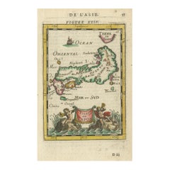
Japanese Isles Map by Mallet, 1683 – Decorative Miniature Map
Located in Langweer, NL
1683 Map of Japan Isles by Mallet – Decorative Miniature Map
This is an original antique map titled “Isles du Japon,” created by Alain Manesson Mallet and published in Paris in 1683...
Category
Antique 1680s French Maps
Materials
Paper
Map of Scandinavia – Antique Atlas Map by A. Levasseur, France, 1875
Located in Langweer, NL
Map of Scandinavia – Antique Atlas Map by A. Levasseur, France, 1875
This elegant 19th-century map titled Carte des Royaumes de Suède, de Norvège et de Danem...
Category
Antique Late 19th Century French Maps
Materials
Paper

$385 Sale Price
35% Off
H 24.02 in W 18.71 in D 0.02 in
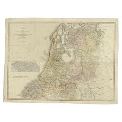
Cary’s Map of the Low Countries – Antique 1813 British Map
Located in Langweer, NL
Antique map of the Netherlands titled 'A New Map of the United Provinces comprehending Holland, Zealand, Utrecht, Gelders, Over Yssel, Friesland and Groningen (..)'. Scarce re-editio...
Category
Antique 19th Century English Maps
Materials
Paper
Antique Map of Wisconsin with Inset Geological Map of Wisconsin
Located in Langweer, NL
Antique map titled 'Wisconsin'. Original antique map of Wisconsin, United States. With inset geological map of Wisconsin. This print originates from '...
Category
Antique Late 19th Century Maps
Materials
Paper
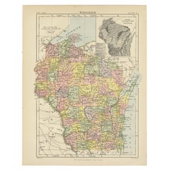
$275 Sale Price
20% Off
H 10.63 in W 8.27 in D 0.02 in
More From This Seller
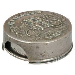
View AllVintage Cycling Telescopic Drinking Beaker
Located in Oxfordshire, GB
Antique Telescopic Cyclists Cup.
A cyclists telescopic cup made up of five graduating rings to form a relatively large cup with a turned over lip. The Victorian collapsible travel, bicycle cup has an embossed lid with a charming scene of two cyclists on a tandem (one male and one female) passing a stone mile marker...
Category
Antique 1890s American Edwardian Sports Equipment and Memorabilia
Materials
Metal
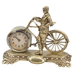
Antique Cycling Clock in Brass
Located in Oxfordshire, GB
Antique Novelty Desk Cycling Clock.
An unusual late 19th Century novelty bicycle clock mounted on a brass base. The gilt-brass bike has a 6 cm clock as a front wheel, clock with blac...
Category
Antique 1890s British Table Clocks and Desk Clocks
Materials
Brass
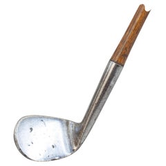
Antique Smooth Face Rut Niblick Golf Club.
Located in Oxfordshire, GB
Antique Rut Niblick.
A good quality, smooth faced, rut niblick golf club with hickory shaft. The head stamped on the back 'hand forged' with a 'golf club' cleek mark. There is the fa...
Category
Antique Late 19th Century British Sporting Art Sports Equipment and Memo...
Materials
Steel
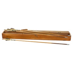
Antique Box Of Archery Arrows
Located in Oxfordshire, GB
Vintage Thomas Aldred Arrows in Case
A set of six vintage archery target arrows, each bearing the owner's name: Olive Knight. The arrows are fit...
Category
20th Century British Sporting Art Sports Equipment and Memorabilia
Materials
Wood
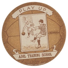
Baines Football Trade Card, Adel Training School, Play Up
Located in Oxfordshire, GB
Baines football trade card, Adel Training School, Play Up.
A rare circular football trade card in the shape of a leather football ball. Made by the toy shop owner from Bradford, John Baines. Baines went on to produce not only football cards...
Category
Vintage 1920s British Sporting Art Sports Equipment and Memorabilia
Materials
Paper
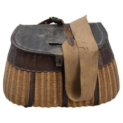
Early Cane And Leather Fishing Creel
Located in Oxfordshire, GB
Early Cane Creel.
A very good example of an early wicker fishing creel. The finely woven wicker creel is made in the traditional design and is with leather trim, leather and canvas s...
Category
Antique Late 19th Century Sports Equipment and Memorabilia
Materials
Cane
Still Thinking About These?
All Recently ViewedMore Ways To Browse
Antique Distillery
Scotch Whisky
Antique Whisky Bottle
Antique Russian Rugs
For Kids
Sterling Silver Flatware Set Service For 12
Tufted Bar
Pair Of French Antique Armchairs
1970s Brass Glass Coffee Table
Charles Rennie Mackintosh For Cassina
Glass Salt
Italian Modern Silver Vases
Vintage Resin Tables
Antique English Country Furniture
Blue Kilim Vintage
Contemporary Side Tables And Stools
Decorative Wall Plate
Mid Century Modern Corner Chair