Items Similar to Philippines, China, Japan
Korea – Jesuit Map with Guam Inset, Scherer c.1700


Want more images or videos?
Request additional images or videos from the seller
1 of 10
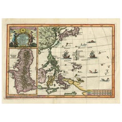
Philippines, China, Japan
Korea – Jesuit Map with Guam Inset, Scherer c.1700
$885.72
£658.11
€740
CA$1,213.26
A$1,323.60
CHF 702.01
MX$15,946.36
NOK 8,909.86
SEK 8,157.22
DKK 5,637.23
About the Item
Title: Philippines, China, Japan
Korea – Jesuit Map with Guam Inset, Scherer c.1700
Description:
This fascinating and richly detailed map depicts the Philippines, China, Japan, and Korea, set within the wider context of East and Southeast Asia, and includes a large and highly detailed inset map of Guam. It originates from the monumental Atlas Novus by Heinrich Scherer, one of the most original and intellectually ambitious cartographic projects of the early 18th century.
The map reflects European geographic knowledge of the Far East around 1700, showing coastal China, the Korean peninsula, the Japanese archipelago, the Philippine islands, and parts of Southeast Asia extending toward New Guinea. Latitude lines, the Equator, and the Tropics are clearly marked, while ships and sea creatures animate the surrounding oceans. The large inset of Guam underscores the strategic and missionary importance of the Mariana Islands within the Spanish and Jesuit world.
Heinrich Scherer (1628–1704) was a Jesuit scholar and professor of Hebrew, mathematics, and ethics at the University of Dillingen, later serving as tutor to the princely houses of Mantua and Bavaria. It was during his time in Munich that his cartographic work gained recognition. Scherer’s Atlas Novus, first published between 1702 and 1710, comprised seven thematic volumes and included 180 maps prepared between 1699 and 1700, engraved by Leonard Hecknaeur, Joseph Montelegre, and Matthus Wolfgang.
What distinguishes Scherer’s maps is their strong Catholic iconography and their pioneering thematic approach. As a Jesuit, Scherer infused his cartography with religious symbolism, visually charting the spread of Catholicism through Jesuit missionary activity. Many maps contrast regions of light and darkness to express the perceived reach of the Catholic faith, notably depicting China optimistically as enlightened despite the limited success of early Jesuit missions there. This map exemplifies Scherer’s role as a forerunner of thematic cartography, blending geography, religion, and ideology into a powerful visual statement.
Condition report:
Original centerfold as issued. Light overall toning consistent with age. Minor handling marks. Original hand coloring remains clear and vibrant.
Framing tips:
Float-mount with a warm ivory or light grey mat to preserve the margins and emphasize the decorative cartouche and inset. A dark wood or black frame enhances the strong outlines and vivid coloring.
Technique: Copper engraving with original hand coloring
Maker: Heinrich Scherer
Date: circa 1700
- Dimensions:Height: 10.63 in (27 cm)Width: 15.75 in (40 cm)Depth: 0.01 in (0.2 mm)
- Materials and Techniques:Paper,Engraved
- Place of Origin:
- Period:
- Date of Manufacture:Circa 1700
- Condition:Original centerfold as issued. Light overall toning consistent with age. Minor handling marks. Original hand coloring remains clear and vibrant.
- Seller Location:Langweer, NL
- Reference Number:Seller: BG-14215-21stDibs: LU3054348119702
About the Seller
5.0
Recognized Seller
These prestigious sellers are industry leaders and represent the highest echelon for item quality and design.
Platinum Seller
Premium sellers with a 4.7+ rating and 24-hour response times
Established in 2009
1stDibs seller since 2017
2,819 sales on 1stDibs
Typical response time: 1 hour
- ShippingRetrieving quote...Shipping from: Langweer, Netherlands
- Return Policy
More From This Seller
View AllAntique Map of the Philippines and Guam by Scherer, circa 1702
Located in Langweer, NL
Antique map titled 'Nova et Vera Exhibitio Geographica Insularum Marianarum (..)'. Rare and very attractive map of the Mariana Islands, Philippines, Ko...
Category
Antique Early 18th Century Dutch Maps
Materials
Paper
$1,723 Sale Price
36% Off
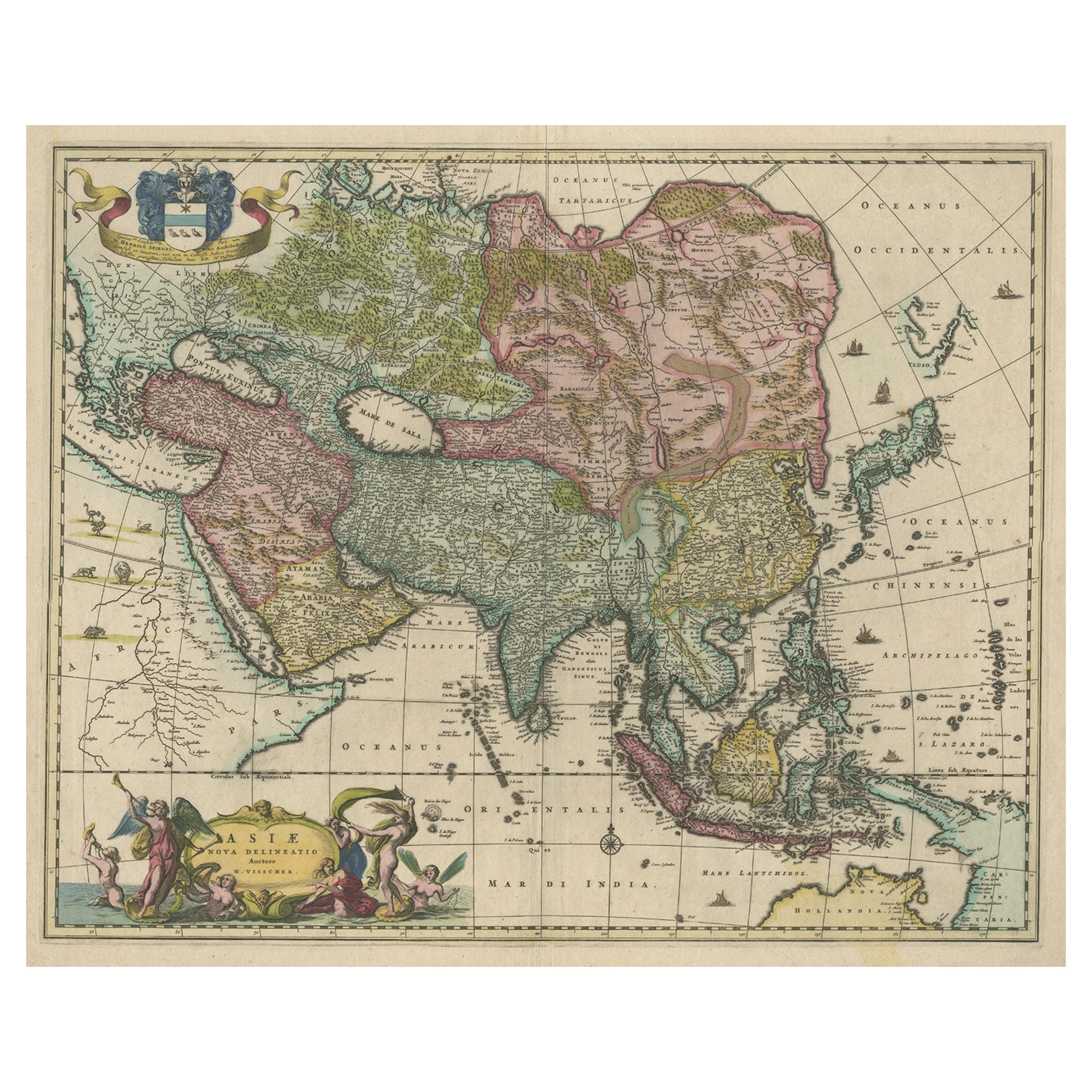
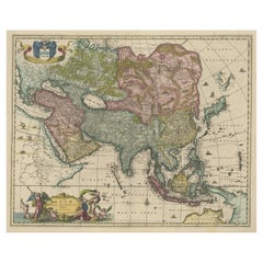
Antique Map of Asia and the East Indies and Korea as a Peninsula, ca.1660
Located in Langweer, NL
Antique map titled 'Asiae nova delineatio'. Decorative map of Asia and the East Indies. The map shows Korea as a peninsula. In China the Great Wall is depicted, as well as a long str...
Category
Antique 17th Century Maps
Materials
Paper
$2,393 Sale Price
20% Off
Free Shipping
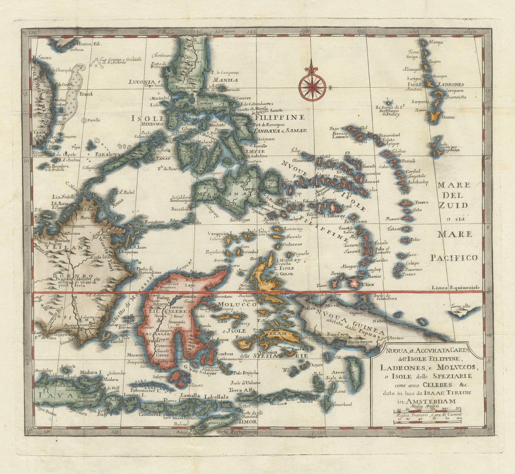
1738 Map of the Philippines
Eastern Indonesia: Spice Islands by Tirion
Located in Langweer, NL
1738 Map of the Philippines & Eastern Indonesia: Spice Islands by Tirion/Albrizzi
This beautifully hand-colored map from circa 1738, created by Tirion and Albrizzi, showcases the Philippines and the eastern part of Indonesia, reflecting the Dutch colonial interests in the region.
The map features a detailed representation of the numerous islands, including the renowned Spice or Banda Islands, pivotal to the Dutch spice trade.
Key regions include the Philippines (Isole Filippine), the Mariana Islands (Ladrones), with Guam, the Caroline and Palau Islands (Nieuwe Fillippynsche Eilenden), the Moluccas (Moluccos) known as the Spice Islands, the eastern tip of Java and Borneo, and a portion of Papua New Guinea.
Measuring 12.8 inches wide by 11.1 inches high, the map is in excellent condition with a crisp impression, slight foxing, and minor printer's creases, printed on a bright sheet with a lion watermark.
Keywords:
- Philippines historical map
- Eastern Indonesia map...
Category
Antique 1730s European Maps
Materials
Paper

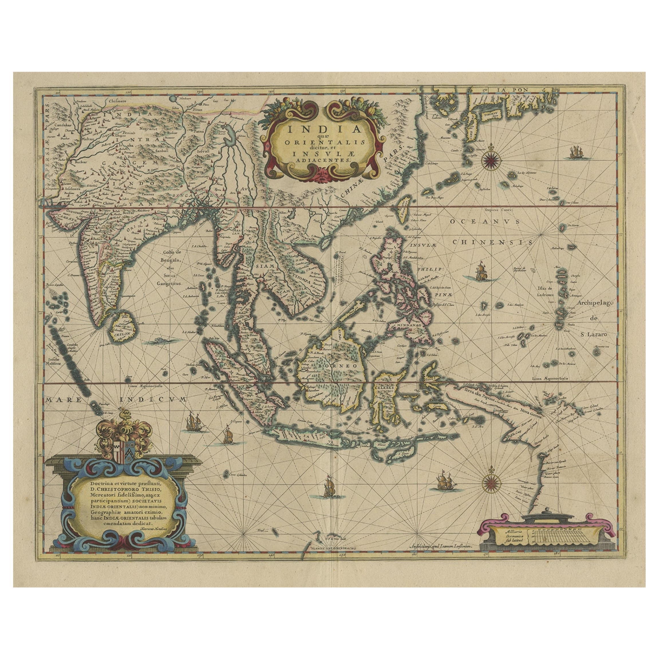
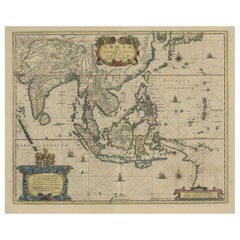
Old Antique Map of the East Indies and Southeast Asia, ca.1644
Located in Langweer, NL
Antique map titled 'India quae Orientalis dicitur, et Insulae adiacentes'.
Old map of the East Indies and Southeast Asia showing the area between India in the West and parts of Japan, the Marianas and New Guinea/Australia in the East. This map is dedicated to D. Christophorus Thisius by Henricus...
Category
Antique 1640s Dutch Maps
Materials
Paper

$2,378 Sale Price
25% Off
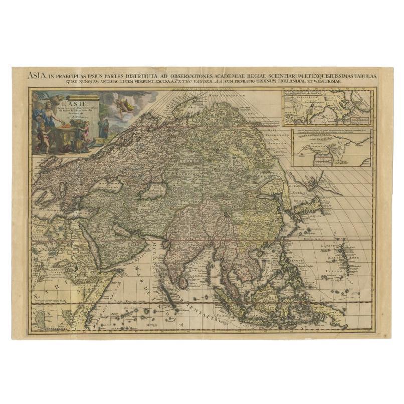
Important and Scarce Antique Map of Asia from Jesuit Sources, C.1713
Located in Langweer, NL
Antique map titled 'L'Asie selon les nouvelles observations de Messrs de l'Academie des Sciences etc'. The main focus of this important and scarce map of Asia is the delineation of the northeast part of the continent from Jesuit sources. The northeast coast is severely truncated with the discoveries of Nicolas Witsen shown, and the partial coastlines of Jesso and Compagnies Land are depicted to the north of Japan. Inset in the North Pacific is a map of that same region based on the information from Father Martino Martini. It shows Jesso connected to the mainland with a narrow strait between it and a huge Compagnies Land. An inset below, taken from Father Ferdinand Verbiest, illustrates the road between Peking and Kirin and Nincrita. Father Verbiest's world map of 1674, which he compiled for the Chinese, subsequently led to the Jesuits obtaining a commission to make a comprehensive topographical...
Category
Antique 18th Century Maps
Materials
Paper

$3,351 Sale Price
20% Off
Original Antique Hand-Colored Map of The East Indies and Southeast Asia, c.1644
Located in Langweer, NL
Antique map titled 'India quae Orientalis dicitur, et Insulae adiacentes'.
Old map of the East Indies and Southeast Asia showing the area between India in the West and parts of J...
Category
Antique 1640s Maps
Materials
Paper
$2,393 Sale Price
20% Off
You May Also Like
Asia Declineatio: A 17th Century Hand-colored Map of Asia by Justus Danckerts
Located in Alamo, CA
This is a scarce 17th century beautifully hand-colored copperplate engraved map of Asia entitled “Exactissima Asiae Delineatio in Praecipuas Regiones Caerterasque Partes divisa et de...
Category
Late 17th Century Old Masters Landscape Prints
Materials
Engraving

Antique Map - Mare Pacificum - Etching by Johannes Janssonius - 1650s
By Johannes Janssonius
Located in Roma, IT
Mare Pacificum is an antique map realized in 1650 by Johannes Janssonius (1588-1664).
The Map is Hand-colored etching, with coeval watercolorang.
Good conditions with slight foxing...
Category
1650s Modern Figurative Prints
Materials
Etching

Map of the East Indies: An Original 18th Century Hand-colored Map by E. Bowen
Located in Alamo, CA
This is an original 18th century hand-colored map entitled "An Accurate Map of the East Indies Exhibiting the Course of the European Trade both on the Continent and Islands" by Emanu...
Category
Mid-18th Century Old Masters Landscape Prints
Materials
Engraving

$1,020 Sale Price
20% Off
Antique Map - Archipela Meridionalis - Etching by Johannes Janssonius - 1650s
By Johannes Janssonius
Located in Roma, IT
Antique Map - Archipela Meridionalis is an antique map realized in 1650 by Johannes Janssonius (1588-1664).
The Map is Hand-colored etching, with coeval watercolorang.
Good conditi...
Category
1650s Modern Figurative Prints
Materials
Etching

Antique French Map of Asia Including China Indoneseia India, 1783
Located in Amsterdam, Noord Holland
Very nice map of Asia. 1783 Dedie au Roy.
Additional information:
Country of Manufacturing: Europe
Period: 18th century Qing (1661 - 1912)
Condition: Overall Condition B (Good Used)...
Category
Antique 18th Century European Maps
Materials
Paper

$486 Sale Price
40% Off
Antique 1803 Italian Map of Asia Including China Indoneseia India
Located in Amsterdam, Noord Holland
Antique 1803 Italian Map of Asia Including China Indoneseia India
Very nice map of Asia. 1803.
Additional information:
Type: Map
Country of Manufacturing: Europe
Period: 19th centu...
Category
Antique 19th Century European Maps
Materials
Paper

$438 Sale Price
39% Off