Items Similar to Phoenician Trade Routes – Antique Map of Europe and the Mediterranean, 1748

Want more images or videos?
Request additional images or videos from the seller
1 of 10
Phoenician Trade Routes – Antique Map of Europe and the Mediterranean, 1748
$348.31
£258.24
€290
CA$478.50
A$522.36
CHF 275.03
MX$6,257.22
NOK 3,517.50
SEK 3,211.53
DKK 2,209.69
About the Item
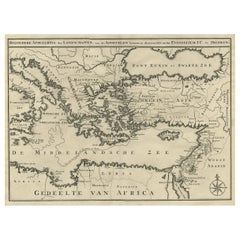
Phoenician Trade Routes – Antique Map of Europe and the Mediterranean, 1748
This antique German map titled Vorstellung von Europa zur Erläuterung der Schifffahrt der Phönicier auf dem Mittelländischen Meer (Representation of Europe for the Explanation of the Navigation of the Phoenicians on the Mediterranean Sea) offers a fascinating historical interpretation of the Mediterranean and adjacent regions through the lens of ancient Phoenician maritime activity. Created around 1748 by Kreitz, this copper-engraved map was published to illustrate the extent of Phoenician trade and exploration, which flourished from around 1500 to 300 BCE.
The map spans from the Atlantic coast of Hispania and Mauretania in the west to Mesopotamia and the Caspian Sea in the east, and from southern England and Tartary in the north to the deserts of North Africa and Arabia in the south. Highlighted regions include ancient Europe (Germania, Gallia, Hispania, Italia, Thracia, Macedonia), Asia Minor (Phrygia, Lydia, Cilicia, Cappadocia), Mesopotamia (Babylonia, Assyria, Chaldea), and important islands like Cyprus, Crete, Sicily, and the Balearic Isles.
Cartographic elements reflect historical names and classical geography, including:
Atlantisches Meer (Atlantic Ocean)
Mittelländisches Meer (Mediterranean Sea)
Schwartze Meer (Black Sea)
Ancient cities such as Babylon and Tarsus
Mountain ranges like Ararat
Rivers including the Danube and Euphrates
The map combines geographic knowledge of the early modern period with classical nomenclature, designed to visualize how the ancient Phoenicians may have navigated and influenced trade across the Mediterranean. It reflects Enlightenment-era interest in antiquity, biblical history, and classical civilizations.
Published in Nuremberg, this map would likely have accompanied a scholarly or educational atlas of the mid-18th century. Its purpose was both didactic and decorative, appealing to collectors, educators, and those fascinated by the ancient world.
Condition: Very good condition. Strong impression with original hand coloring. Minor age-toning to the edges and faint centerfold creases. Wide margins preserved, but left margin short. Visible plate mark.
Framing tips: A classic antique gold or walnut frame paired with a cream or parchment-colored mat will enhance the historic and academic character of this early map. Ideal for libraries, offices, or study rooms.
Technique: Copper engraving with original hand color
Maker: Kreitz, published c.1744, likely Nuremberg
- Dimensions:Height: 7.49 in (19 cm)Width: 13.08 in (33.2 cm)Depth: 0.01 in (0.2 mm)
- Materials and Techniques:Paper,Engraved
- Period:
- Date of Manufacture:1748
- Condition:Condition: Very good condition. Strong impression with original hand coloring. Minor age-toning to the edges and faint centerfold creases. Wide margins preserved, but left margin short. Visible plate mark.
- Seller Location:Langweer, NL
- Reference Number:Seller: BG-06655-181stDibs: LU3054346172472
About the Seller
5.0
Recognized Seller
These prestigious sellers are industry leaders and represent the highest echelon for item quality and design.
Platinum Seller
Premium sellers with a 4.7+ rating and 24-hour response times
Established in 2009
1stDibs seller since 2017
2,811 sales on 1stDibs
Typical response time: 1 hour
- ShippingRetrieving quote...Shipping from: Langweer, Netherlands
- Return Policy
More From This Seller
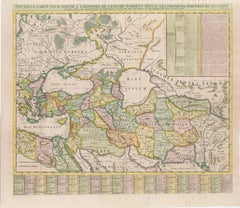
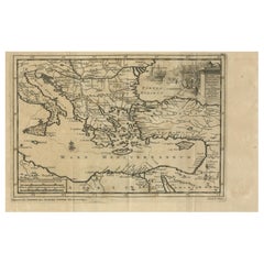
View All18th-Century Map of the Eastern Roman Empire by Henri Chatelain, c. 1719
Located in Langweer, NL
Title: 18th-Century Map of the Eastern Roman Empire by Henri Chatelain, c. 1719
Description: This intricately detailed map, titled *Nouvelle Carte pour Servir à l'Histoire de l'Empi...
Category
Antique 1710s Maps
Materials
Paper
Ancient World Map of Europe, Asia
Northern Africa with Ancient Names, 1725
Located in Langweer, NL
Antique map titled 'Geografische Kaarte van de Oude Weereld (..).'
Original antique map of the ancient world depicting Europe, Asia, and northern Africa with ancient place names....
Category
Antique 1720s French Maps
Materials
Paper
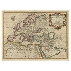
$1,201 Sale Price
20% Off
Ottoman Empire Map 1719 – Europe Asia Africa, Jean Chiquet, Paris
Located in Langweer, NL
Title: Ottoman Empire Map 1719 – Europe Asia Africa, Jean Chiquet, Paris
Description:
Original early-18th-century engraved map titled Estats de l’Empire du Grand Seigneur, depicting...
Category
Antique Early 18th Century French Maps
Materials
Paper
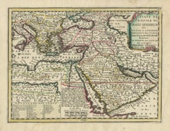
Scarce Map of the Mediterranean and Parts of Europe, Africa
Middle East, 1725
Located in Langweer, NL
Antique map titled: Byzondere afbeelding der landschappen, van de Apostelen bevaren en doorwandelt, om het Evangelium J.C. te prediken.
Scarce map of the Mediterranean and contigu...
Category
Antique 1720s Dutch Maps
Materials
Paper
Antique Map of Eastern Mediterranean and Asia Minor by a Benedictine, c.1725
Located in Langweer, NL
Antique map titled 'Byzondere Afbeelding der Landschappen, van de Apostelen bevaren en doorwandelt om het Evangelium J. C. te Prediken.' Map of the lands travelled by the Apostles to...
Category
Antique 18th Century French Maps
Materials
Paper

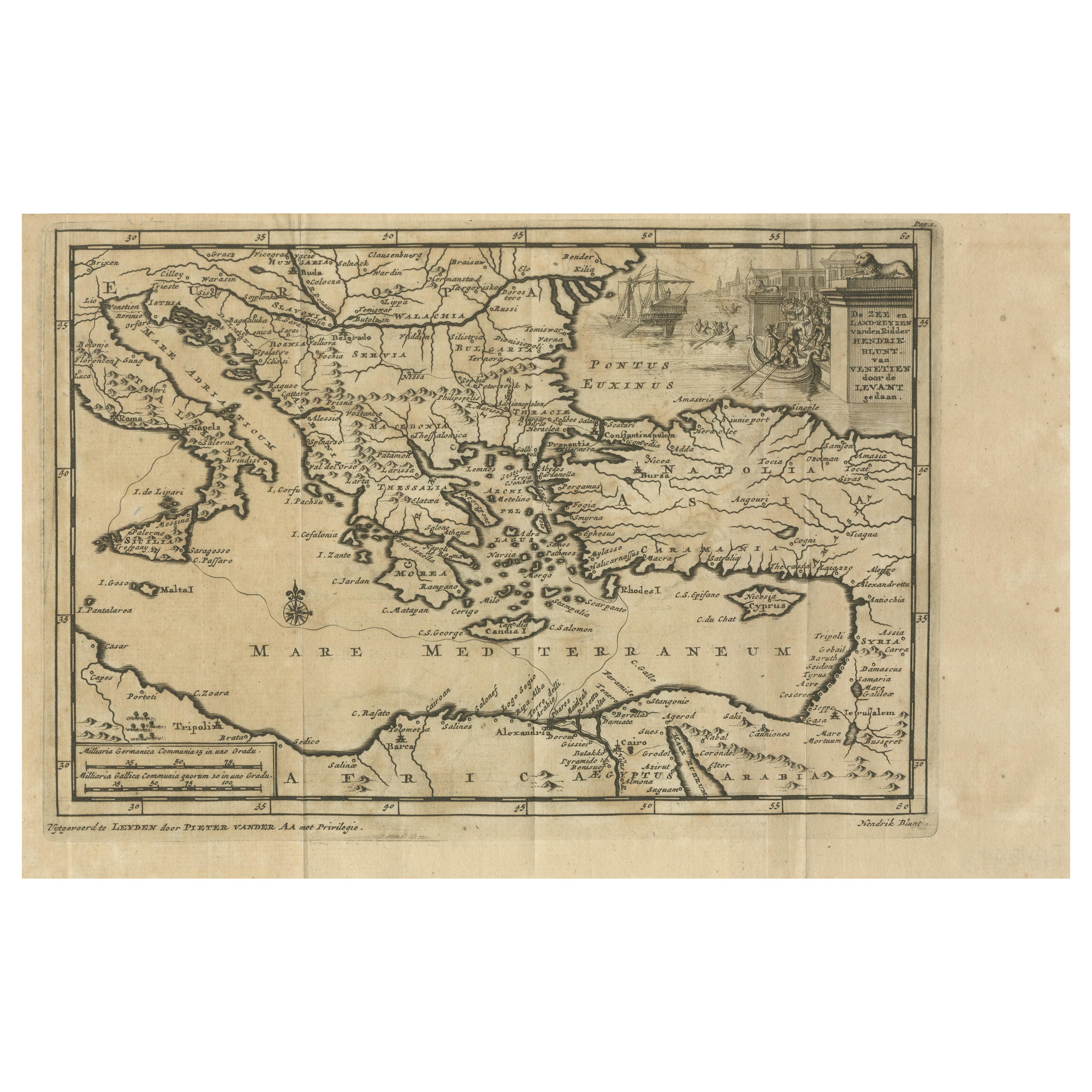
Venetian Trade Routes in the Levant – Antique Map by Pieter van der Aa, ca.1720
Located in Langweer, NL
Venetian Trade Routes in the Levant – Antique Map by Pieter van der Aa, Early 18th Century
This finely engraved map, published by Pieter van der Aa in Leiden, provides a detailed d...
Category
Antique 1720s Maps
Materials
Paper
You May Also Like
Southern
Eastern Europe: A Large 17th C. Hand-colored Map by Sanson
Jaillot
By Nicolas Sanson
Located in Alamo, CA
This large hand-colored map entitled "Estats de L'Empire des Turqs en Europe, ou sont les Beglerbeglicz our Gouvernements" was originally created by Nicholas Sanson d'Abbeville and t...
Category
Antique 1690s French Maps
Materials
Paper

$1,740 Sale Price
20% Off
1718 Ides
Witsen Map "Route D
amsterdam a Moscow Et De La Ispahan Et Gamron
Located in Norton, MA
1718 Ides & Witsen map, entitled
"Route D'Amsterdam A Moscow Et De La Ispahan Et Gamron,"
Ric.b005
Subject: Eastern Europe and Central Asia
Period: 1718 (published)
Publicati...
Category
Antique Early 18th Century Dutch Maps
Materials
Paper

17th Century Nicolas Visscher Map of Southeastern Europe
Located in Hamilton, Ontario
A beautiful, highly detailed map of southeastern Europe by Nicolas Visscher. Includes regions of Northern Italy (showing the cities Bologna, Padua, and Venice), Bohemia, Austria (sho...
Category
Antique 17th Century Dutch Maps
Materials
Paper

$1,350 Sale Price
38% Off
Southern
Eastern Europe: A Large 17th C. Hand-colored Map by Sanson
Jaillot
By Nicholas Sanson d
Abbeville
Located in Alamo, CA
This large hand-colored map entitled "Estats de L'Empire des Turqs en Europe, ou sont les Beglerbeglicz our Gouvernements" was originally created by Nicholas Sanson d'Abbeville and this version was published by Hubert Jaillot in "Atlas Nouveau" in Paris in 1692. It depicts the territories of the Ottoman Empire in Europe, predominantly Eastern Europe. Highlights include, the Mediterranean Sea, the Adriatic Sea, the Black Sea, the Dalmation Coast including present day Croatia, Bosnia and Herzegovina, Montenegro, Serbia, Slovenia, Italy, Greece, North Macedonia, Turkey, Romania, Hungary, Albania, Kosovo, Bulgaria, Transylvania, Moldova and southern portions of France, Switzerland, Germany, and Poland..
The map consists of two sheets joined as one along a vertical joint. The map has original hand-coloring. It is printed on antique hand-made laid, chain-linked paper with wide margins. The sheet measures 24.88" high and 38" wide. There is a central vertical joint, as issued. The map is in very good condition.
Nicholas Sanson d'Abbeville (1600-1667) was one of the greatest French cartographather of French cartography. Sanson opened his first printing business in Paris in 1638. The king recognized his skill and knowledge and made him the official geographer to the court. He eventually served two kings in this capacity. Sanson was succeeded by his sons and son...
Category
1690s Landscape Prints
Materials
Engraving

Mediterranean and Adriatic Seas: Original 18th Century Hand-colored Map by Bowen
Located in Alamo, CA
This is an original 18th century hand-colored map entitled "An Accurate Chart of The Mediterranean and Adriatic Sea's; with the Archipelago & Part of the Black Sea. Exhibiting all th...
Category
Mid-18th Century Old Masters Landscape Prints
Materials
Engraving

Original Antique Map of Ancient Greece, Achaia, Corinth, 1786
Located in St Annes, Lancashire
Great map of Ancient Greece. Showing the region of Thessaly, including Mount Olympus
Drawn by J.D. Barbie Du Bocage
Copper plate engraving by P.F Tardieu
Original hand color...
Category
Antique 1780s French Other Maps
Materials
Paper

More Ways To Browse
Mid Century Mediterranean
Antique Crete
Antique Gallia
Ancient Babylon
Pair Of Danish Chairs
Veneer Dining Tables
1970 Italian Armchair
Furniture Uk
House Of Denmark Table And Chairs
Louis Marble Top Side Table
Antique Russian Rugs
Baker Furniture By
For Kids
Sterling Silver Flatware Set Service For 12
Tufted Bar
Pair Of French Antique Armchairs
1970s Brass Glass Coffee Table
Antique Column Base