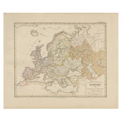
Items Similar to Physical Map of Europe – Nieuwe Hand-Atlas by Frijlink
van Otterloo, 1876


Want more images or videos?
Request additional images or videos from the seller
1 of 9
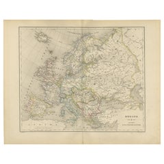
Physical Map of Europe – Nieuwe Hand-Atlas by Frijlink
van Otterloo, 1876
$381.31
£284.02
€320
CA$525.10
A$571.55
CHF 302.85
MX$6,873.79
NOK 3,850.60
SEK 3,528.65
DKK 2,438.19
About the Item
Title: Northern Hemisphere Map Centered on the North Pole, Leiden 1876
Description:
This 19th-century Dutch map titled “Noordpoolkaart” (Map of the North Pole) was published in 1876 in the 'Nieuwe Hand-Atlas der Aarde in haren Tegenwoordigen Toestand' by M. Frijlink, revised by A. van Otterloo, and printed by D. Noothoven van Goor in Leiden. The circular projection presents the northern hemisphere viewed from above the Arctic, offering a fascinating perspective on the geography of Europe, Asia, and North America during an era when much of the polar region remained unexplored.
The map uses fine lithographic lines with delicate hand-coloring to outline political boundaries—yellow for the Americas, pink for Asia, and blue for Europe. It shows the Arctic Ocean surrounded by Greenland, Scandinavia, Siberia, Alaska, and northern Canada, along with early routes of exploration and major northern islands. This projection highlights the relative proximity of continents across the polar regions and was designed to help students and scholars understand global geography beyond the equatorial view.
Produced as part of Frijlink’s educational atlas, this chart reflects the scientific curiosity of the late 19th century, when expeditions sought to uncover the mysteries of the North Pole. The clarity and elegance of the engraving show the high standards of Dutch lithography, with a balance of accuracy and aesthetic restraint typical of academic cartography of the time.
Condition report:
Good condition with light overall toning and faint foxing near the margins. Original center fold as issued. The printed surface remains crisp, and colors are soft and well-preserved. No tears or repairs visible.
Framing tips:
This circular composition displays beautifully in a square or round-cut mount. A neutral off-white mat with a dark wood or black frame emphasizes the symmetry and calm tones. Ideal for display in a study or modern interior with an interest in exploration or geographic history.
Technique: Lithograph with original hand-coloring
Maker: M. Frijlink
A. van Otterloo, published by D. Noothoven van Goor, Leiden, 1876
- Dimensions:Height: 17.33 in (44 cm)Width: 21.66 in (55 cm)Depth: 0.01 in (0.2 mm)
- Materials and Techniques:
- Place of Origin:
- Period:
- Date of Manufacture:1876
- Condition:Good condition with light overall toning and faint foxing near the margins. Original center fold as issued. The printed surface remains crisp, and colors are soft and well-preserved. No tears or repairs visible.
- Seller Location:Langweer, NL
- Reference Number:Seller: BG-12788-51stDibs: LU3054347454282
About the Seller
5.0
Recognized Seller
These prestigious sellers are industry leaders and represent the highest echelon for item quality and design.
Platinum Seller
Premium sellers with a 4.7+ rating and 24-hour response times
Established in 2009
1stDibs seller since 2017
2,824 sales on 1stDibs
Typical response time: 1 hour
- ShippingRetrieving quote...Shipping from: Langweer, Netherlands
- Return Policy
More From This Seller
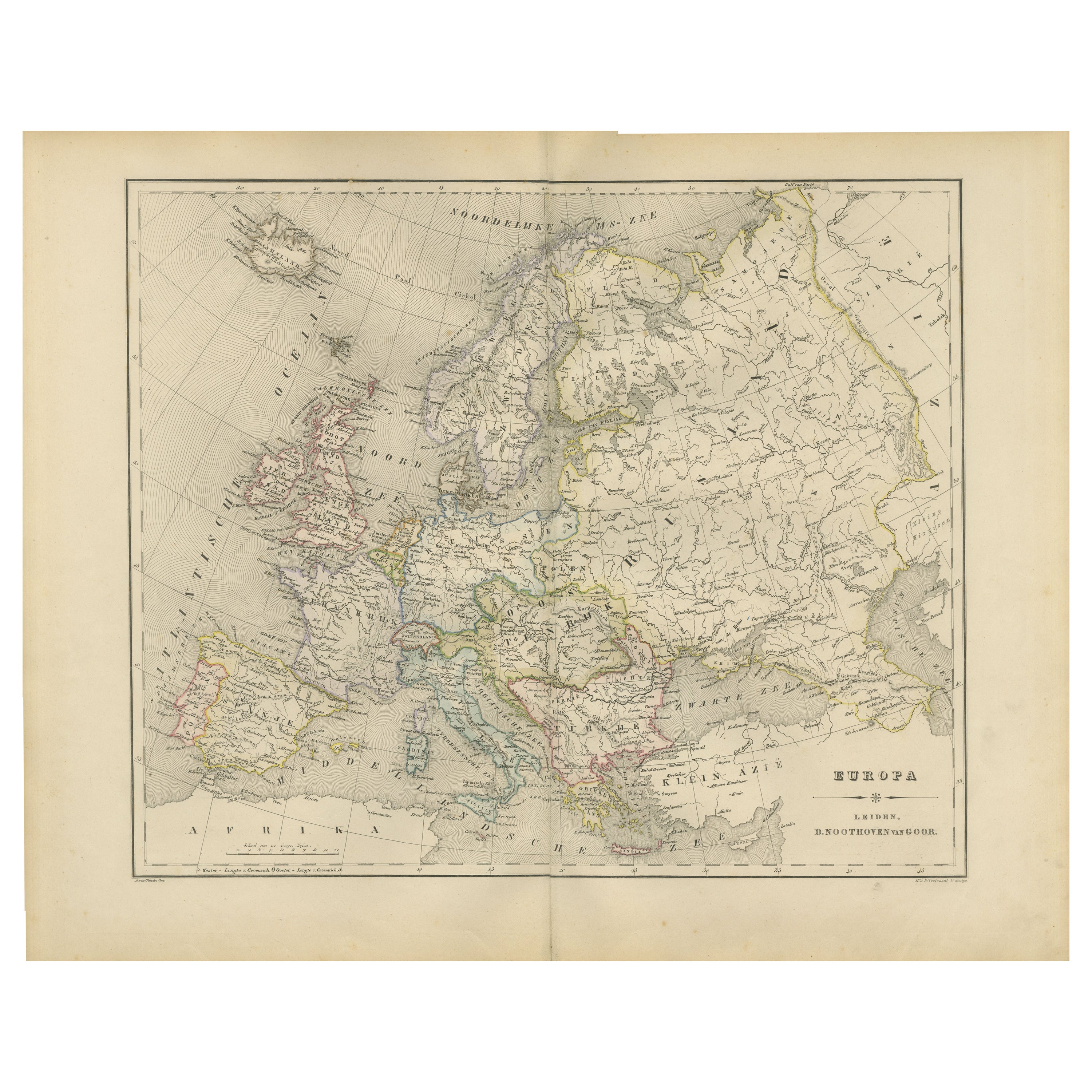
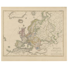
View AllPolitical Map of Europe – Nieuwe Hand-Atlas by Frijlink
van Otterloo, 1876
Located in Langweer, NL
Title: Political Map of Europe – Nieuwe Hand-Atlas by Frijlink & van Otterloo, 1876
Description:
This 19th-century Dutch map titled “Europa” was published in 1876 in the Nieuwe Hand...
Category
Antique 1870s Dutch Maps
Materials
Paper
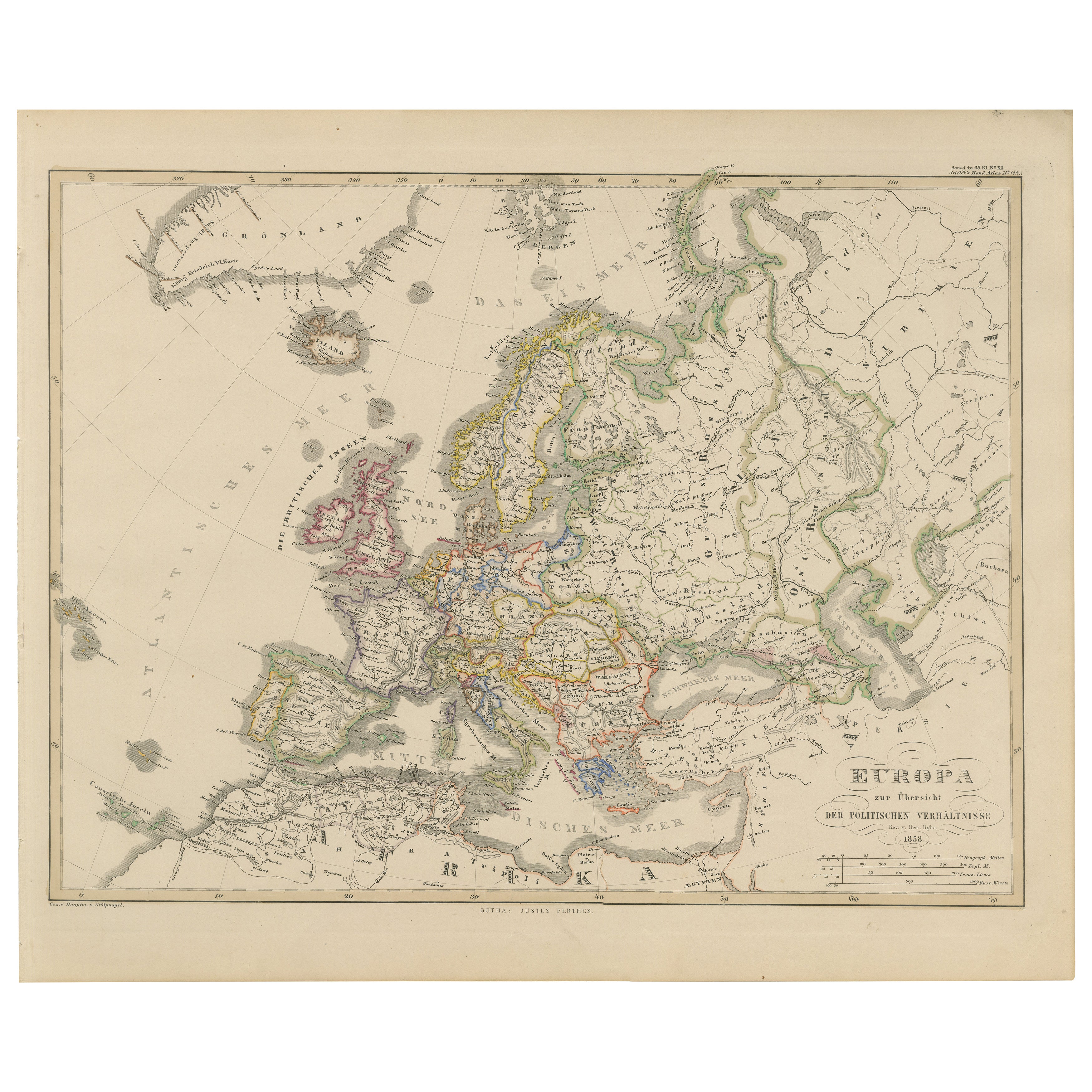
Europe Map – Political Divisions and Borders, Published in 1858
Located in Langweer, NL
Europe Map – Political Divisions and Borders 1858
This fine antique print shows Europe with its political divisions titled “Europa zur Übersicht der politischen Verhältnisse” meanin...
Category
Antique Mid-19th Century German Maps
Materials
Paper
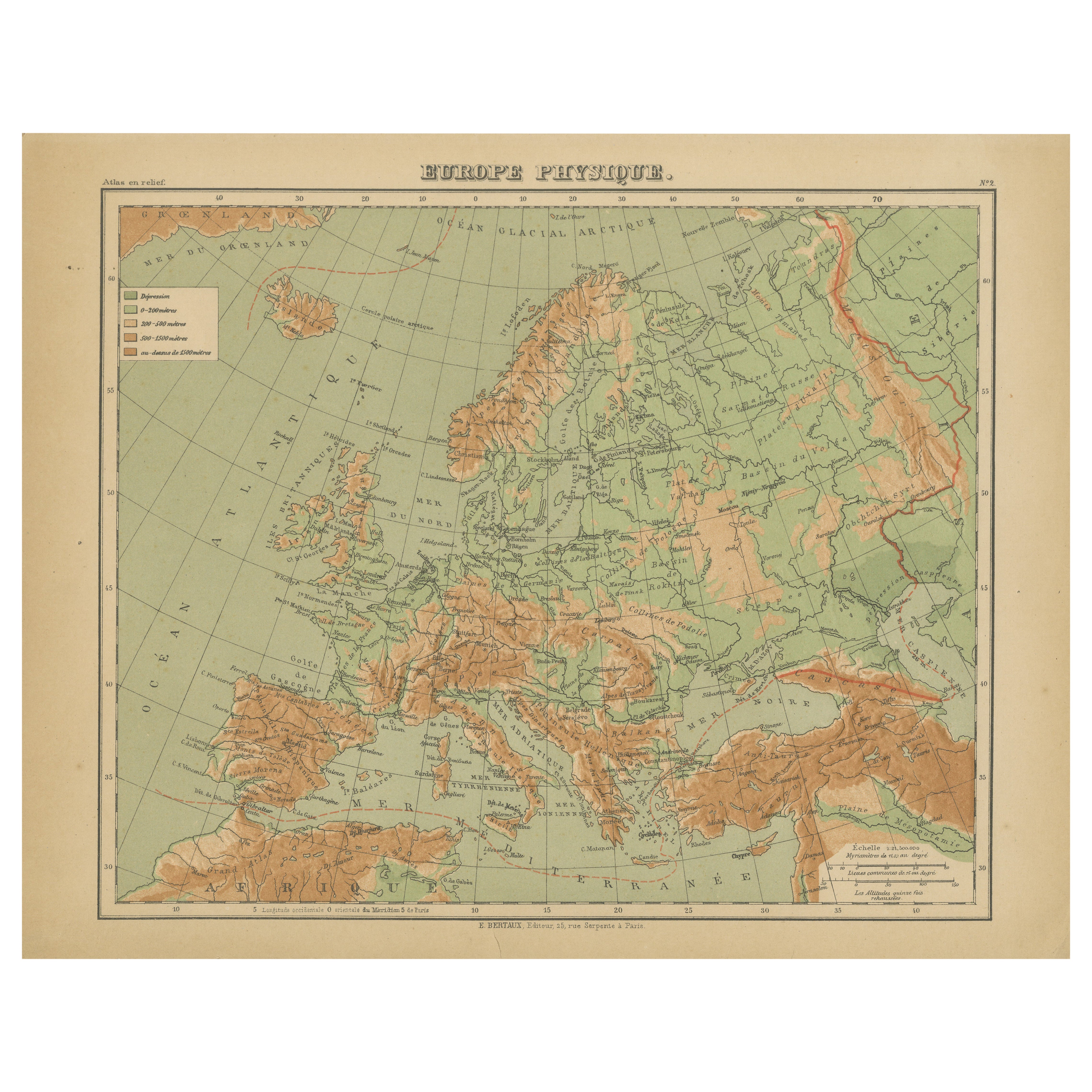
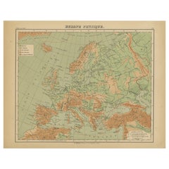
Relief Atlas Map of Europe by Hachette – Antique French Map c.1883
Located in Langweer, NL
Antique Map of Europe – Physical Relief Map by Hachette, circa 1883
Description:
This antique map titled “Europe Physique” was published by Hachette in Paris around 1883 and origina...
Category
Antique Late 19th Century French Maps
Materials
Paper
Antique Map of Europe, 1903, with Intricate Political Boundaries and Rich Detail
Located in Langweer, NL
Title: Antique Map of Europe, 1903, with Intricate Political Boundaries and Rich Detail
Description:
This antique map, titled "Europe," is a finely engraved and beautifully colored ...
Category
Early 20th Century Maps
Materials
Paper

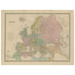
Antique Map of Europe – Political Divisions by Andriveau-Goujon, Paris 1861
Located in Langweer, NL
Antique Map of Europe – Political Divisions by Andriveau-Goujon, Paris 1861
This beautifully engraved and hand-colored antique map of Europe was published in 1861 by the Parisian ca...
Category
Antique Mid-19th Century French Maps
Materials
Paper
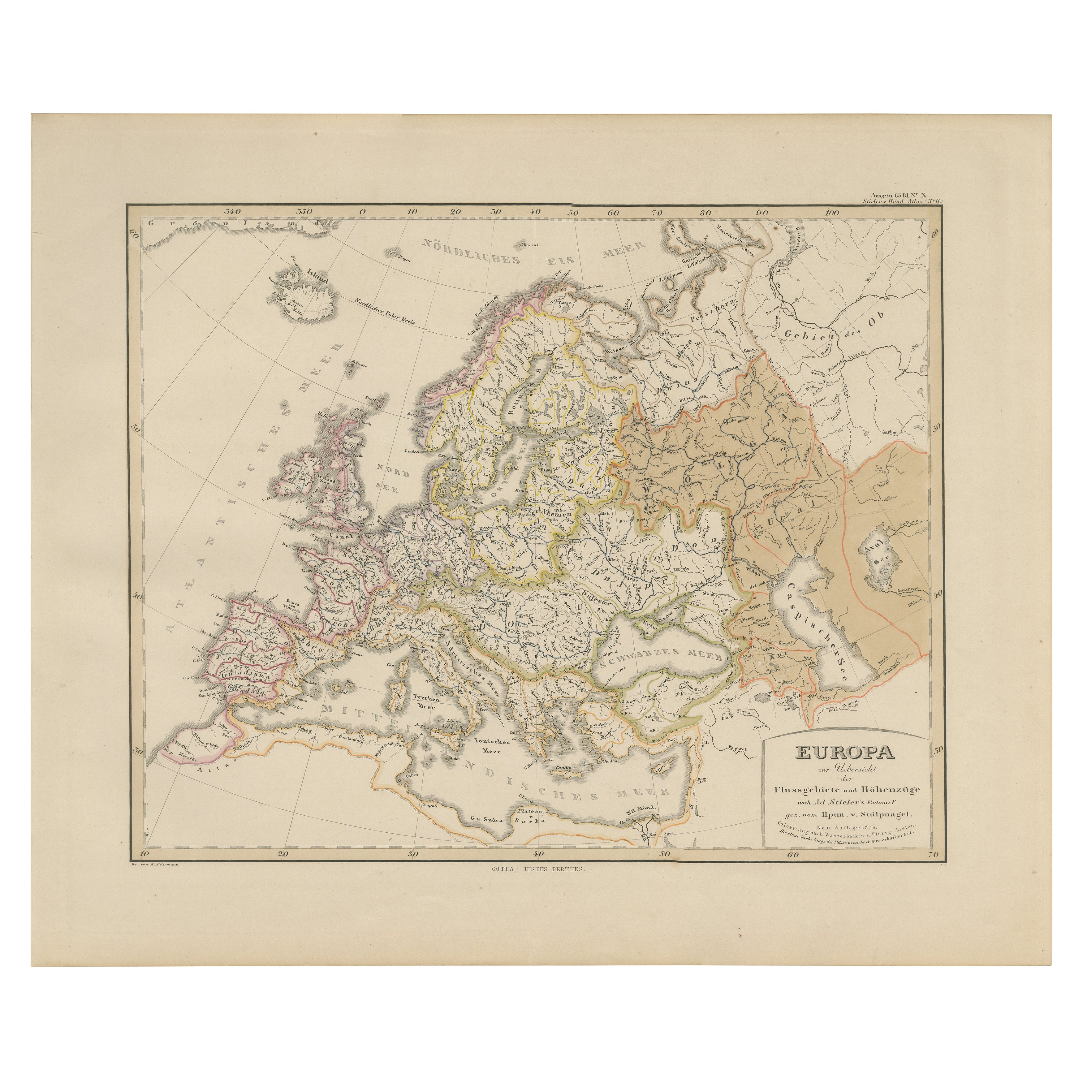
Europe Map – Rivers, Watersheds and Elevation, Published in 1857
Located in Langweer, NL
Europe Map – Rivers, Watersheds and Elevation 1857
This beautiful antique print shows Europe with its river systems and watershed regions, titled “Europa zur Übersicht der Flussgebi...
Category
Antique Mid-19th Century German Maps
Materials
Paper
You May Also Like
Map of Europe, 1844
Located in Houston, TX
Over 150 year old engraved map of Europe by Olney from 1844. Original hand color. Shows Northern Europe, Prussia and Germany.
Original antique map o...
Category
1840s More Prints
Materials
Ink, Watercolor, Handmade Paper

Original Antique Map of Europe, Arrowsmith, 1820
Located in St Annes, Lancashire
Great map of Europe
Drawn under the direction of Arrowsmith.
Copper-plate engraving.
Published by Longman, Hurst, Rees, Orme and Brown, 1820
...
Category
Antique 1820s English Maps
Materials
Paper

Large Original Antique Map of Europe by Sidney Hall, 1847
Located in St Annes, Lancashire
Great map of Europe
Drawn and engraved by Sidney Hall
Steel engraving
Original colour outline
Published by A & C Black. 1847
Unframed
Free shipping.
Category
Antique 1840s Scottish Maps
Materials
Paper

Russia in Europe with Poland and Finland. Century Atlas antique vintage map
Located in Melbourne, Victoria
'The Century Atlas. Russia in Europe with Poland and Finland'
Original antique map, 1903.
Central fold as issued. Map name and number printed on the reverse corners.
Sheet 40cm by ...
Category
Early 20th Century Victorian More Prints
Materials
Lithograph

1849 Map of "Europaische Russland",
Meyer Map of European Russia
, Ric. R017
Located in Norton, MA
1849 Map of
"Europaische Russland"
( Meyer Map of European Russia)
Ric.r017
A lovely map of European Russia dating to 1849 by Joseph Meyer. It covers the European portions of...
Category
Antique 19th Century Unknown Maps
Materials
Paper

The Netherlands (Holland), Belgium and Luxemburg. Century Atlas antique map
Located in Melbourne, Victoria
'The Century Atlas. The Netherlands (Holland), Belgium and Luxemburg.'
Original antique map, 1903.
Inset maps of 'Amsterdam' and 'Brussels'.
Central fold as issued. Map name and num...
Category
Early 20th Century Victorian More Prints
Materials
Lithograph
