Items Similar to Plan of Lima and View of Potosí – Peru
Bolivia City Plan and Mining View, 1750
Want more images or videos?
Request additional images or videos from the seller
1 of 11
Plan of Lima and View of Potosí – Peru
Bolivia City Plan and Mining View, 1750
$408.42
£302.30
€340
CA$558.96
A$608.65
CHF 322.01
MX$7,340.14
NOK 4,097.07
SEK 3,745.59
DKK 2,590.05
About the Item
Plan of Lima and View of Potosí – Peru
Bolivia City Plan and Mining View c.1750
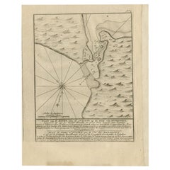
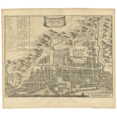
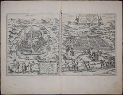
This original antique engraving combines two important South American subjects on a single sheet: a detailed 'plan of the city of Lima' and a 'view of Potosí', one of the most significant mining centers of the early modern world. The upper portion is titled A Plan of Lima and is marked “Vol. I, p. 243,” indicating that it was issued as part of a larger illustrated travel or historical publication. The lower view of Potosi is correspondingly referenced to page 246.
The plan of Lima shows the city in a rectilinear grid pattern typical of Spanish colonial urban planning. Streets, blocks, fortifications, gates, public buildings, and open spaces are carefully delineated, with the river running through the city clearly indicated. A numbered key below the plan identifies principal features such as churches, gates, markets, hospitals, and administrative buildings, reflecting Lima’s role as the capital of the Viceroyalty of Peru and a major center of Spanish power in South America.
The lower image depicts Potosí, dominated by the Cerro Rico, the silver-rich mountain that made the city one of the wealthiest in the world during the 16th–18th centuries. The engraving illustrates mining activity and ore processing, including windmills and watermills used for grinding and cleaning silver ore, as explained in the engraved caption. The town spreads across the foothills below, conveying both the scale of the settlement and the industrial nature of its economy.
Together, these images provide a valuable contemporary European view of Spanish colonial administration and resource extraction in South America. The sheet is both historically informative and visually engaging, appealing to collectors of early city plans, colonial Latin American history, and mining or economic history.
Condition report:
Overall age-related toning and light surface wear. Original folds as issued. Some edge wear and small handling marks, consistent with use in a bound volume.
Framing tips:
Float-mount with a warm ivory mat to preserve the full margins and printed captions. A simple dark wood or black frame complements the fine line engraving and documentary character.
Technique: Copper engraving
Maker: Unknown
Date: circa mid-18th century
- Dimensions:Height: 16.42 in (41.7 cm)Width: 9.85 in (25 cm)Depth: 0.01 in (0.2 mm)
- Materials and Techniques:Paper,Engraved
- Place of Origin:
- Period:
- Date of Manufacture:Circa 1750
- Condition:Overall age-related toning and light surface wear. Original folds as issued. Some edge wear and small handling marks, consistent with use in a bound volume.
- Seller Location:Langweer, NL
- Reference Number:Seller: BG-14215-41stDibs: LU3054348119682
About the Seller
5.0
Recognized Seller
These prestigious sellers are industry leaders and represent the highest echelon for item quality and design.
Platinum Seller
Premium sellers with a 4.7+ rating and 24-hour response times
Established in 2009
1stDibs seller since 2017
2,819 sales on 1stDibs
Typical response time: 1 hour
- ShippingRetrieving quote...Shipping from: Langweer, Netherlands
- Return Policy
More From This Seller
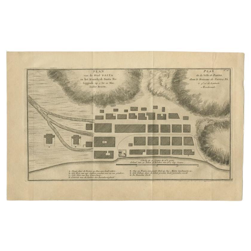
View AllAntique Plan of the City of Paita in Peru, by Anson, 1749
Located in Langweer, NL
Antique map titled 'Plan van de Stad Paita in het Koninkryk Santa Fee (..) - Plan de la Ville de Paita (..)'. Original antique plan of the city of Paita, Peru. This map originates fr...
Category
Antique 18th Century Maps
Materials
Paper
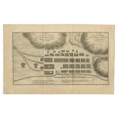
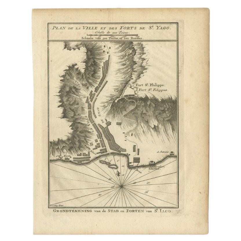
Antique Plan of Santiago, Chili, 1747
By Jakob van der Schley
Located in Langweer, NL
Antique print titled 'Plan de la Ville et des Forts de St. Yago, Grondtekening van de Stad en Forten van St. Iago'. Plan of the forts and town of Santiago, the largest island of Cape...
Category
Antique 18th Century Maps
Materials
Paper
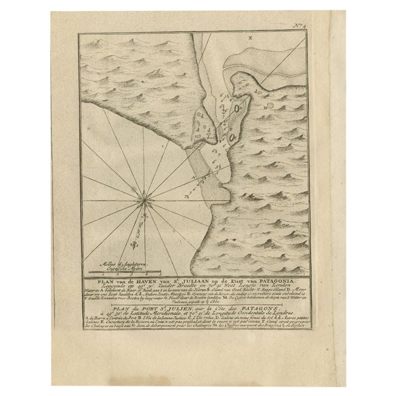
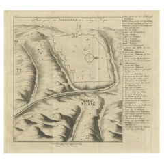
Antique Map of Puerto San Julian in Patagonia, 1749
Located in Langweer, NL
Antique map titled 'Plan van de Haven van St. Juliaan op de Kust van Patagonia (..) - Plan du Port St. Julien, sur la Côte des Patagons (..)'. Original antique map of St. Julian on t...
Category
Antique 18th Century Maps
Materials
Paper
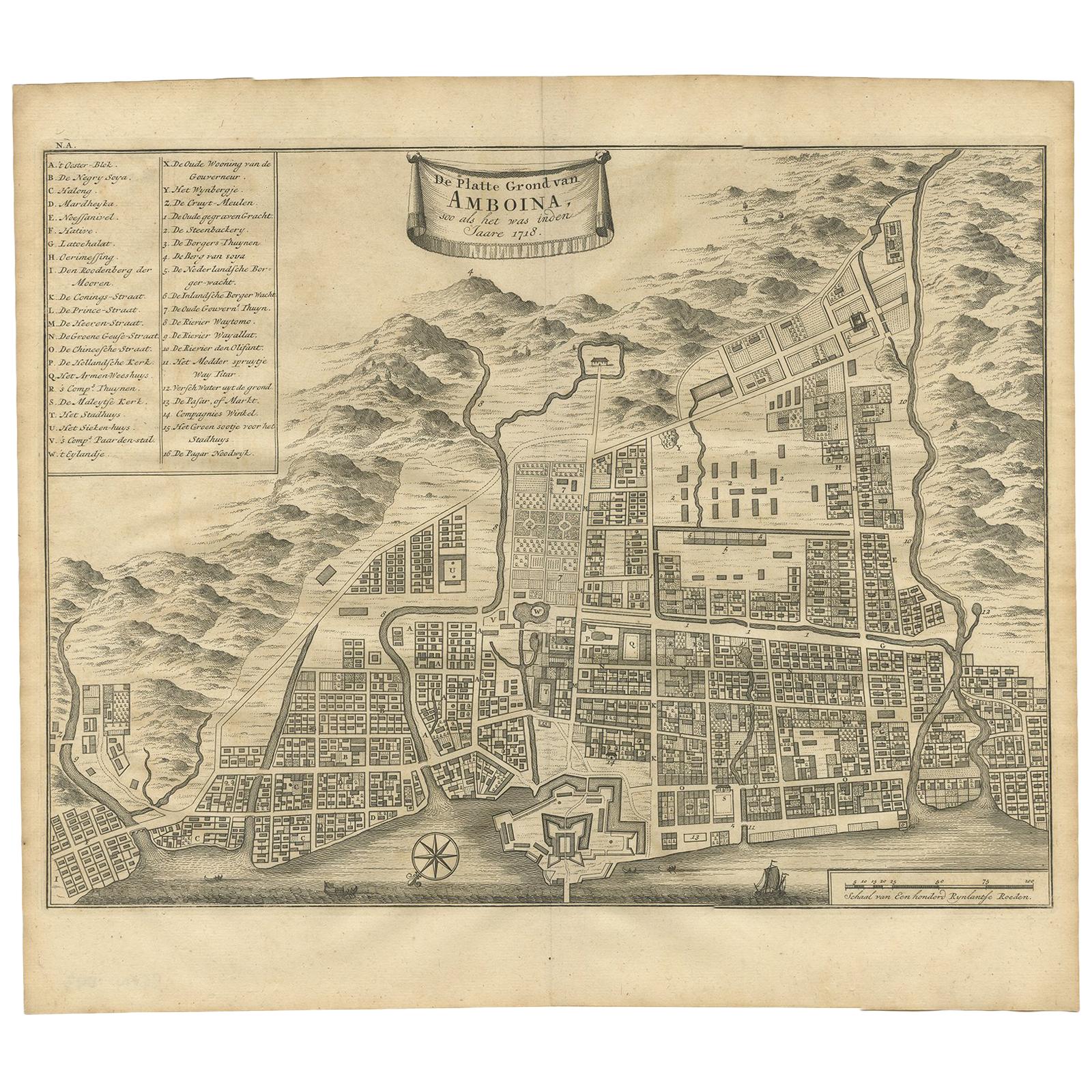
Antique Map of the City of Ambon by Valentijn, 1726
By F. Valentijn
Located in Langweer, NL
Antique map titled 'De Platte Grond van Amboina zoo als het was in den Jaare, 1718'. Antique map depicting the City of Ambon, Indonesia. This print originates from 'Oud en Nieuw Oost...
Category
Antique Early 18th Century Dutch Maps
Materials
Paper
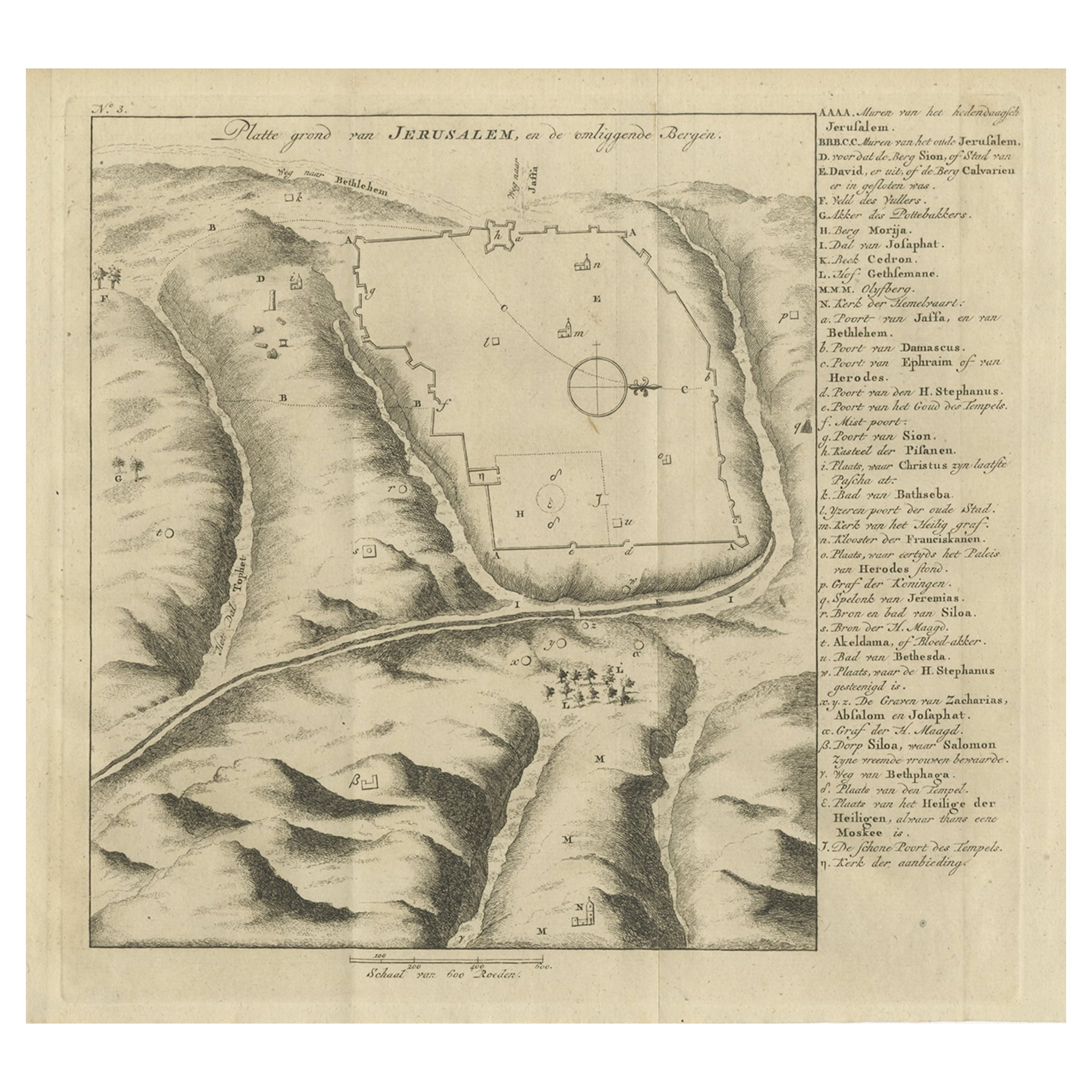
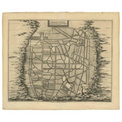
Antique Engraving of a Map or Plan of Jerusalem and Surrounding Mountains, 1773
Located in Langweer, NL
Antique map titled 'Platte grond van Jerusalem, en de omliggende Bergen'. Plan of the city of Jerusalem, with surrounding mountains. Originates from the first Dutch editon of an inte...
Category
Antique 18th Century Maps
Materials
Paper
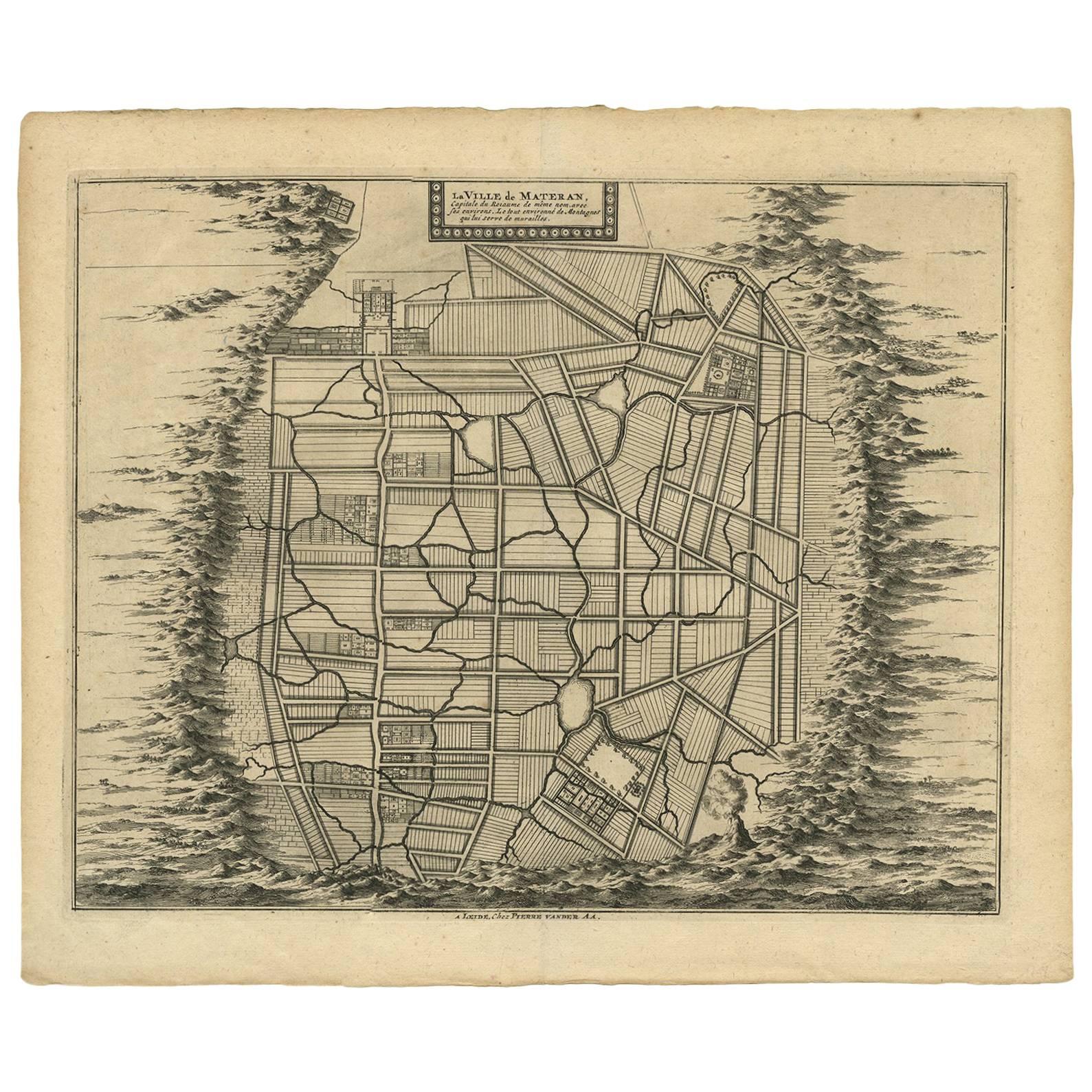
Antique Map of the City of Materan
Indonesia
by P. van der Aa, circa 1725
By Pieter Van Der Aa
Located in Langweer, NL
Antique map titled 'La Ville de Materan, capitale de Roiaume de meme nom, avec ses environs. Le tout environne de Montagnes qui lui serve de murailles.' The city of Materan, capital ...
Category
Antique Early 18th Century Maps
Materials
Paper
$379 Sale Price
20% Off
You May Also Like
Mexico City
Cusco Antique Map, Civitates Orbis Terrarum by Braun
Hogenberg
By Franz Hogenberg
Located in Roma, IT
Etching black and white from Civitates Orbis Terrarum. View of the Old Mexico City, built over the ruins of the Aztec city of Tenochtitlán from 1520, and Cusco, ancient capital of th...
Category
16th Century Landscape Prints
Materials
Etching
18th Century Map Engraving - Plan of the Works of the City of Messina, Sicily
Located in Corsham, GB
A map of Messina, a harbour city in northeast Sicily. Inscribed with the title in plate to the lower edge, 'Plan of the Works of the City of Messina, one of the strongest and most co...
Category
18th Century More Prints
Materials
Engraving

$285 Sale Price
20% Off
Original Antique Map or City Plan of Madrid, Spain. Circa 1835
Located in St Annes, Lancashire
Nice map of Madrid
Drawn and engraved by J.Dower
Published by Orr & Smith. C.1835
Unframed.
Free shipping
Category
Antique 1830s English Maps
Materials
Paper

17th Century Topographical Map of Cote D
azur, Avignon, Frejus by Iohan Peeters
Located in New York, NY
Fine topographical 17th century map by Iohan Peeters of the towns of Avignon and Frejus in the Cote d'Azur-Provence-Alpes Region of Southeastern France.
Beautifully suited decorativ...
Category
Antique 17th Century Dutch Maps
Materials
Paper

Original Antique Map or City Plan of Geneva, Switzerland. Circa 1835
Located in St Annes, Lancashire
Nice map of Geneva
Drawn and engraved by J.Dower
Published by Orr & Smith. C.1835
Unframed.
Free shipping
Category
Antique 1830s English Maps
Materials
Paper

17th Century Toulouse, Savve, Sommieres Topographical Map by Iohan Peeters
Located in New York, NY
Fine topographical 17th century map of Toulouse, Savve and Sommieres by Iohan Peeters
Beautiful engraving of the capital of France's Occitanie Region, Toulouse, called La Ville Rose- the Pink City, for the terracotta bricks used in its many buildings, giving the city a distinct apricot-rose hue. An important cultural and educational center, the city's residents included Nobel Prize winners and world renown artists- Henri de Toulouse-Lautrec, Henri Martin, Jean-Auguste-Dominique Ingres, Antonin Mercie, Alexandre Falguiere and more recently Cyril Kongo...
Category
Antique 17th Century Dutch Maps
Materials
Paper
