Items Similar to Plan of Paris, France, by A. Vuillemin, Antique Map, 1845


Video Loading
Want more images or videos?
Request additional images or videos from the seller
1 of 11
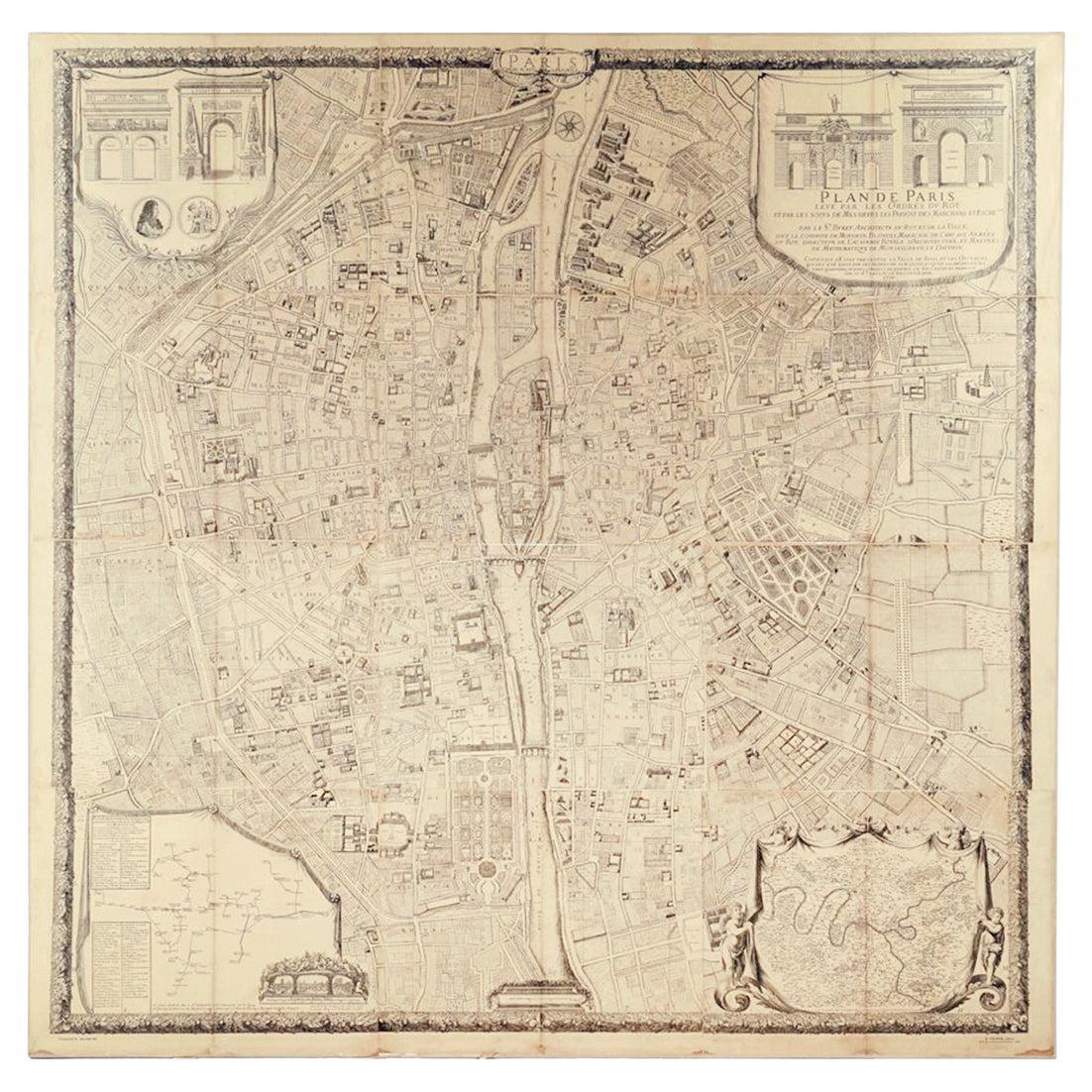
Plan of Paris, France, by A. Vuillemin, Antique Map, 1845
$4,950
£3,769.32
€4,340.27
CA$7,014.59
A$7,545.19
CHF 4,032.37
MX$88,936.30
NOK 50,838.72
SEK 46,476.24
DKK 32,429.16
About the Item
This large and detailed plan of Paris was published by Alexandre Vuillemin in 1845. The map conveys a wonderful amount of information and is decorated throughout with pictorial vignettes of major buildings, bridges, trains, and monuments.
It also includes a table with an alphabetized street index; a list of suburbs with distances to Paris, population and festival days; a table listing forts surrounding Paris with distances to the center of the city; and a list of passages located throughout the city.
Alexandre Vuillemin (1812-1880) was a leading 19th century French cartographer and editor. He studied under French cartographer Auguste Dufour and set up shop in Paris. Vuillemin produced over ten different atlases during his career; many of which were so popular they went through multiple editions. His maps are noted for the frequent use of extensive margin illustrations – vignettes, portraits of famous people, and inset birds-eye views of cities.
CONDITION:
This is a nice impression, with age appropriate toning to the paper. The map has been backed onto linen. It is displayed in a custom archival wood frame with a gold beaded border.
- Dimensions:Height: 42.5 in (107.95 cm)Width: 51.25 in (130.18 cm)Depth: 2.5 in (6.35 cm)
- Materials and Techniques:
- Place of Origin:
- Period:
- Date of Manufacture:1845
- Condition:Additions or alterations made to the original: Rebacked onto new linen. Wear consistent with age and use. Nice impression and backed onto linen with age appropriate toning to the paper.
- Seller Location:Colorado Springs, CO
- Reference Number:Seller: M0771stDibs: LU90974627213
About the Seller
4.9
Platinum Seller
Premium sellers with a 4.7+ rating and 24-hour response times
Established in 2010
1stDibs seller since 2011
474 sales on 1stDibs
Typical response time: 2 hours
- ShippingRetrieving quote...Shipping from: Colorado Springs, CO
- Return Policy
More From This Seller
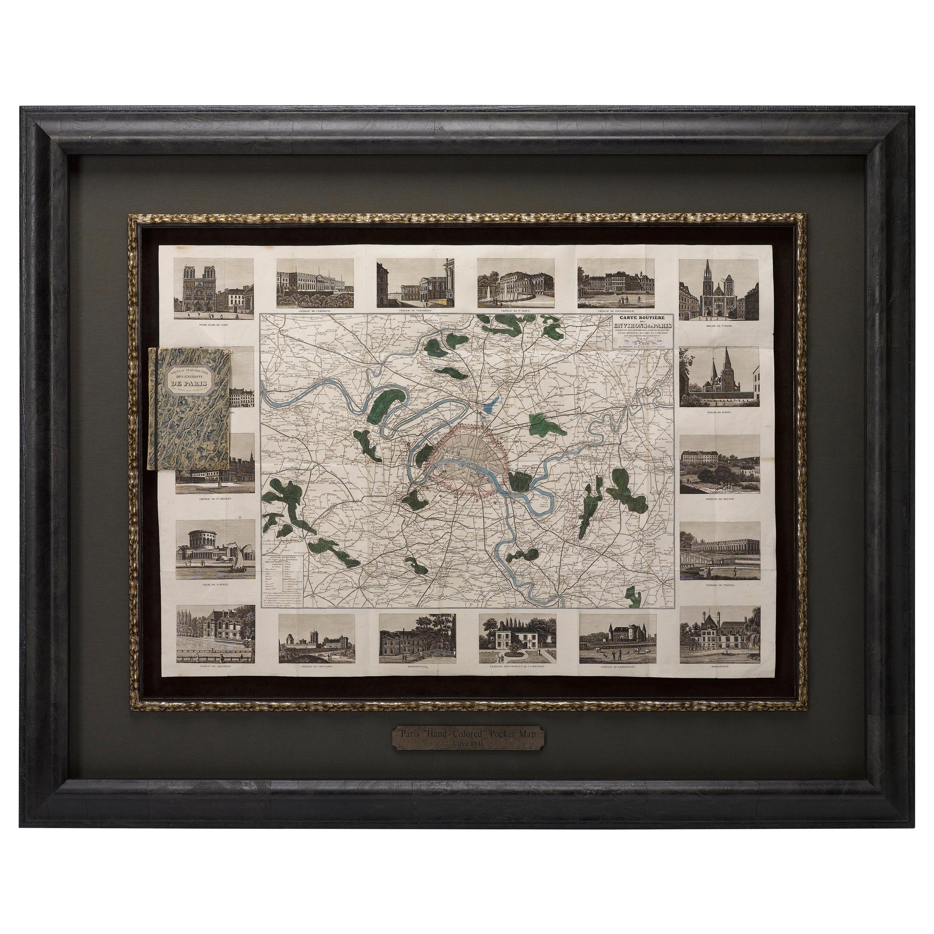
View AllAntique Map of Paris, "Carte Routiere des Environs de Paris" 1841
Located in Colorado Springs, CO
This beautiful hand-colored road map of Paris was published in 1841. The map shows Paris and the surrounding area in a folding pocket map. Organized and detailed for travelers, this ...
Category
Antique 1840s French Maps
Materials
Paper

1840 "New Map of the City of New York With Part of Brooklyn
Williamsburg"
Located in Colorado Springs, CO
Presented is a hand-colored, engraved folding map titled "New Map of the City of New York With Part of Brooklyn & Williamsburg" by J. Calvin Smith. The map was issued bound in the bo...
Category
Antique 1840s American Maps
Materials
Paper

1864 Map of North America, Antique Hand-Colored Map, by Adolphe Hippolyte Dufour
Located in Colorado Springs, CO
Offered is a map of North America entitled Amerique du Nord from 1864. This rare, separately published wall map was produced by Adolphe Hippolyte Dufour. This map includes vibrant an...
Category
Antique 1860s French Maps
Materials
Paper

1856 "Map of the United States" by Ensign, Bridgeman, and Fanning
Located in Colorado Springs, CO
Presented is a scarce American wall map of the United States and Mexico issued by Ensign, Bridgman, and Fanning in 1856. As the title suggests, the map covers all of the United State...
Category
Antique 1850s American Victorian Maps
Materials
Paper

1845 "Ensign
s Travellers
Guide and Map of the United States" Hand-Colored Map
Located in Colorado Springs, CO
This is an exquisite and dramatic steel-engraved wall map of the United States, published by T.
E. H. Ensign in 1845. The map depicts the development and settlement of the Unit...
Category
Antique 1840s American Victorian Maps
Materials
Paper

1859 "Map of the United States of America..." by J. H. Colton
By J.H. Colton
Located in Colorado Springs, CO
Presented is an 1859 “Map of the United States of America, the British Provinces, Mexico, the West Indies and Central America with Part of...
Category
Antique 1850s American Maps
Materials
Paper

You May Also Like
Original Large Antique Map of Paris, France by John Dower, 1861
Located in St Annes, Lancashire
Fabulous monochrome map of Paris.
Vignettes of St Germain En Laye, Saint Cloud, Versailles and Fontainbleau.
Unframed.
Drawn by J.Dower.
Lithography by Weller. 4 sheets joined to...
Category
Antique 1860s English Victorian Maps
Materials
Paper

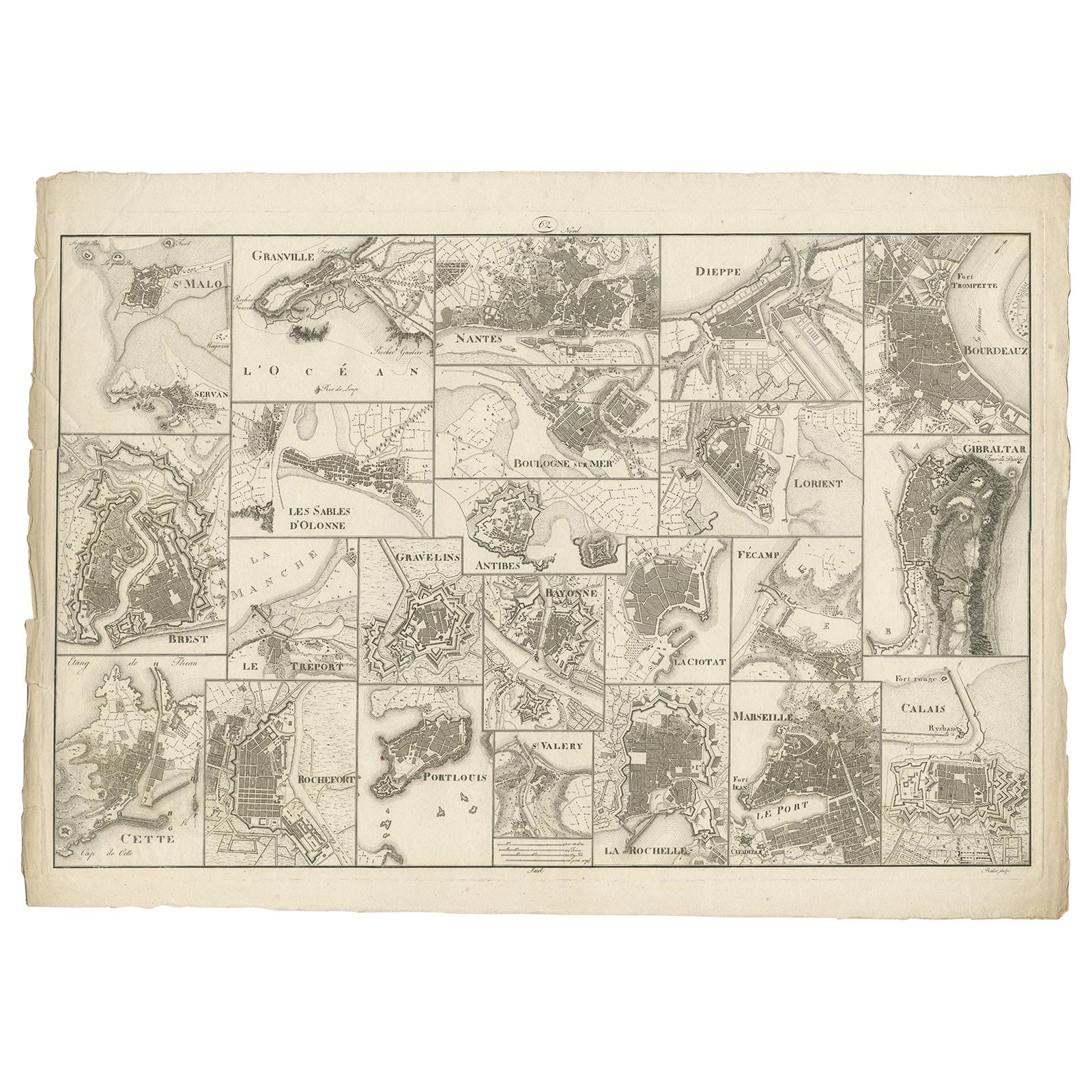
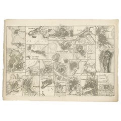
Antique Map of Various Ports in France by Röder
circa 1800
Located in Langweer, NL
Antique print showing various ports in France. Including plans of St. Malo, Granville, Nantes, Dieppe, Bourdeauz, Gibraltar, Lorient, Boulogne sur Mer, Les Sables d'Olonne, Brest, Le Trèport, Antibes, La Ciotat...
Category
Antique Early 19th Century Maps
Materials
Paper
$1,756 Sale Price
20% Off
"Plan de Paris" - Antique Recreation of a Map of Paris
Located in New York, NY
Printed in the Early 20th Century, this antique "Plan de Paris" is a recreation of an earlier map from 1710, originally commissioned by Louis XIV. It was an intricately rendered view...
Category
Early 20th Century French Louis XIV Maps
Materials
Linen, Wood, Paper

Antique Map of the City of Paris by Tirion
1763
Located in Langweer, NL
Antique map titled 'Nieuwe Kaart der platte Grond van de Stad Parys (..)'. Beautiful city plan of Paris, France. This map originates from 'Nieuwe en Beknopte Hand-Atlas, bestaande in...
Category
Antique Mid-18th Century Maps
Materials
Paper

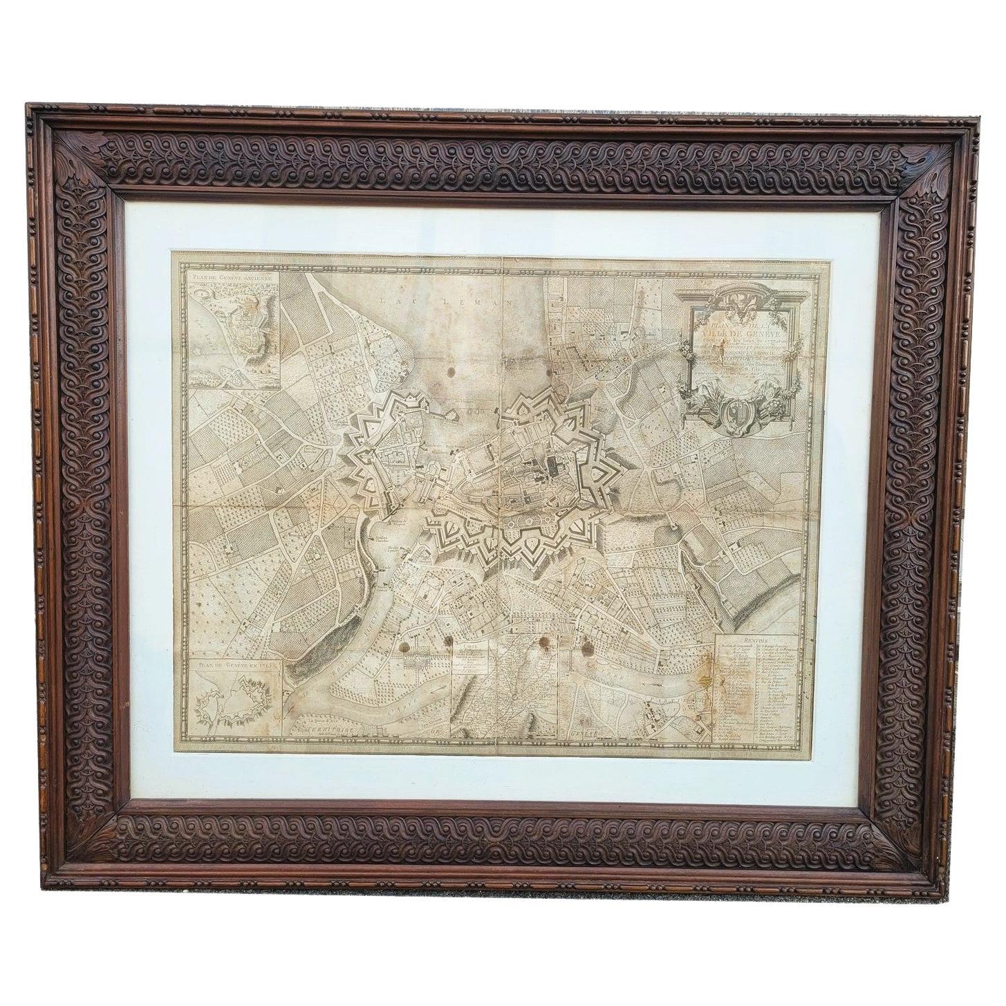
Map Of The City Of Geneva, Framed Engraving, Late 18th Century
Located in MARSEILLE, FR
Beautiful engraving representing the city of Geneva corrected in 1775 and 1793
The engraving also presents inserts with the evolution of the city, the plan of ancient Geneva and ...
Category
Antique Late 18th Century Swiss Louis XV Prints
Materials
Paper

Old Map Depicting the Entire Earth
s Surface Divided into Six Parts France 1850
Located in Milan, IT
Map depicting the entire earth's surface divided into six parts which depicts the position of peoples on Earth based on the assumption that it is impossible for each people to have t...
Category
Antique Mid-19th Century French Maps
Materials
Glass, Wood, Paper

More Ways To Browse
1970 Italian Armchair
House Of Denmark Table And Chairs
Louis Marble Top Side Table
Antique Russian Rugs
Baker Furniture By
For Kids
Sterling Silver Flatware Set Service For 12
Tufted Bar
Pair Of French Antique Armchairs
1970s Brass Glass Coffee Table
Antique Column Base
Charles Rennie Mackintosh For Cassina
Glass Salt
Italian Modern Silver Vases
Vintage Resin Tables
Antique English Country Furniture
Blue Kilim Vintage
Contemporary Side Tables And Stools