Items Similar to Print of Maps of Islands of the South Pacific, Incl. Pitcairn
Dusky Bay, 1788


Want more images or videos?
Request additional images or videos from the seller
1 of 5
Print of Maps of Islands of the South Pacific, Incl. Pitcairn
Dusky Bay, 1788
$527.34
£390.71
€440
CA$727.20
A$769.91
CHF 416.66
MX$9,201.88
NOK 5,193.56
SEK 4,749.32
DKK 3,351.96
About the Item
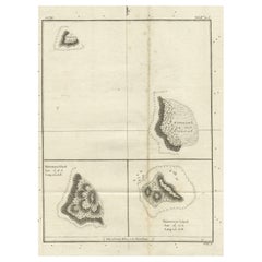
Antique map titled 'Esquisse de la Bay Dusky, Dans La Nouvelle Zeelande / I. Pitcairn / Isles de Wallis / I Turtle / I des Cocos and Traitres / Palmerston I. / I. Suavage / I. D'Hervey/ Havre Pickersgill / I de Pasques.'
Detailed set of maps of the islands of the South Pacific, with a large compass rose and inset of Dusky Bay on New Zealand. This map originates from 'Atlas encyclopedique: contenant la géographie ancienne' by Rigobert Bonne.
Artists and Engravers: Rigobert Bonne (1727-1795 ) was one of the most important cartographers of the late 18th century. In 1773 he succeeded Jacques Bellin as Royal Cartographer to France in the office of the Hydrographer at the Depôt de la Marine. Working in his official capacity Bonne compiled some of the most detailed and accurate maps of the period. Bonne's work represents an important step in the evolution of the cartographic ideology away from the decorative work of the 17th and early 18th century towards a more detail oriented and practical aesthetic. With regard to the rendering of terrain Bonne maps bear many stylistic similarities to those of his predecessor, Bellin. However, Bonne maps generally abandon such common 18th century decorative features such as hand coloring, elaborate decorative cartouches, and compass roses. While mostly focusing on coastal regions, the work of Bonne is highly regarded for its detail, historical importance, and overall aesthetic appeal.
Condition: Good, given age. Irregular edges as issued with an occasinal small tear. A few spots in the margins. Original middle fold as issued. General age-related toning and/or occasional minor defects from handling. Please study image carefully.
- Dimensions:Height: 12.21 in (31 cm)Width: 18.31 in (46.5 cm)Depth: 0 in (0.02 mm)
- Materials and Techniques:
- Period:1780-1789
- Date of Manufacture:1788
- Condition:Condition: Good, given age. Irregular edges as issued with an occasinal small tear. A few spots in the margins. Original middle fold as issued. General age-related toning and/or occasional minor defects from handling. Please study image carefully.
- Seller Location:Langweer, NL
- Reference Number:Seller: PCT-578931stDibs: LU3054326755262
About the Seller
5.0
Recognized Seller
These prestigious sellers are industry leaders and represent the highest echelon for item quality and design.
Platinum Seller
Premium sellers with a 4.7+ rating and 24-hour response times
Established in 2009
1stDibs seller since 2017
2,848 sales on 1stDibs
Typical response time: 1 hour
- ShippingRetrieving quote...Shipping from: Langweer, Netherlands
- Return Policy
More From This Seller
View AllAntique Map of Islands in the Mediterranean by Bowen,
c.1760
Located in Langweer, NL
Antique map titled 'Particular Draughts of some of the chief African Islands (..)'. Eight small maps on one sheet including 'Islands of Malta Goze & Cuming, An Accurate Chart of Cape de Verde Islands…, Island of St Helena.., Island of Madera, Island of Teneriffe, The Bay of Agoa…, The Dutch Fort at the Cape of Good Hope…, A Draught of Table Bay...
Category
Antique Mid-18th Century Maps
Materials
Paper

$479 Sale Price
20% Off
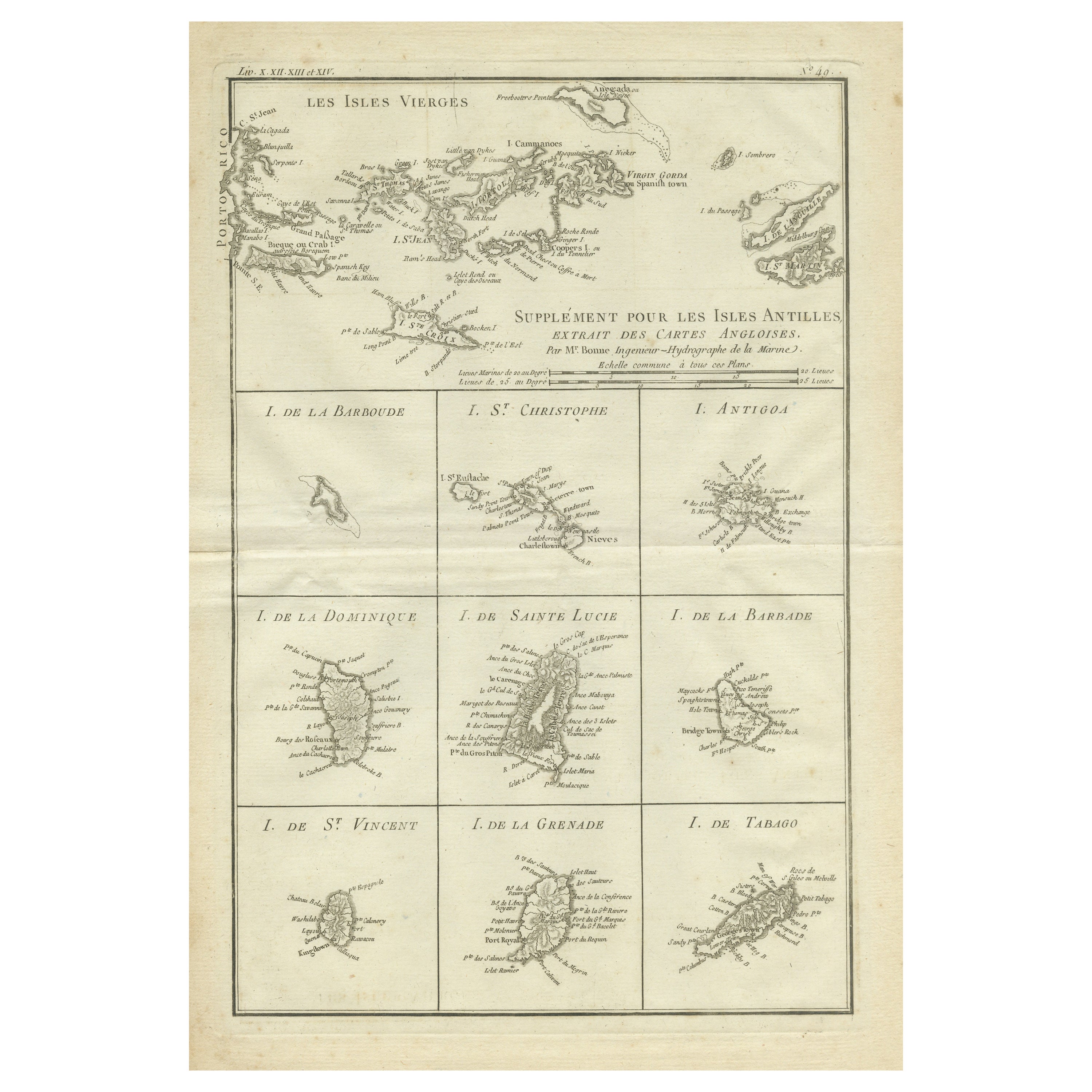
Original Antique Map of the Virgin Islands with Insets of Caribbean Isles, 1787
Located in Langweer, NL
Antique map titled 'Supplément pour les Isles Antilles (..)'. Original old map of the Virgin Islands, with insets of Barbuda, St. Kits, Antigua, Dominica, St. Lucia, Barbados, St. Vi...
Category
Antique Late 18th Century Maps
Materials
Paper
$249 Sale Price
20% Off
Free Shipping
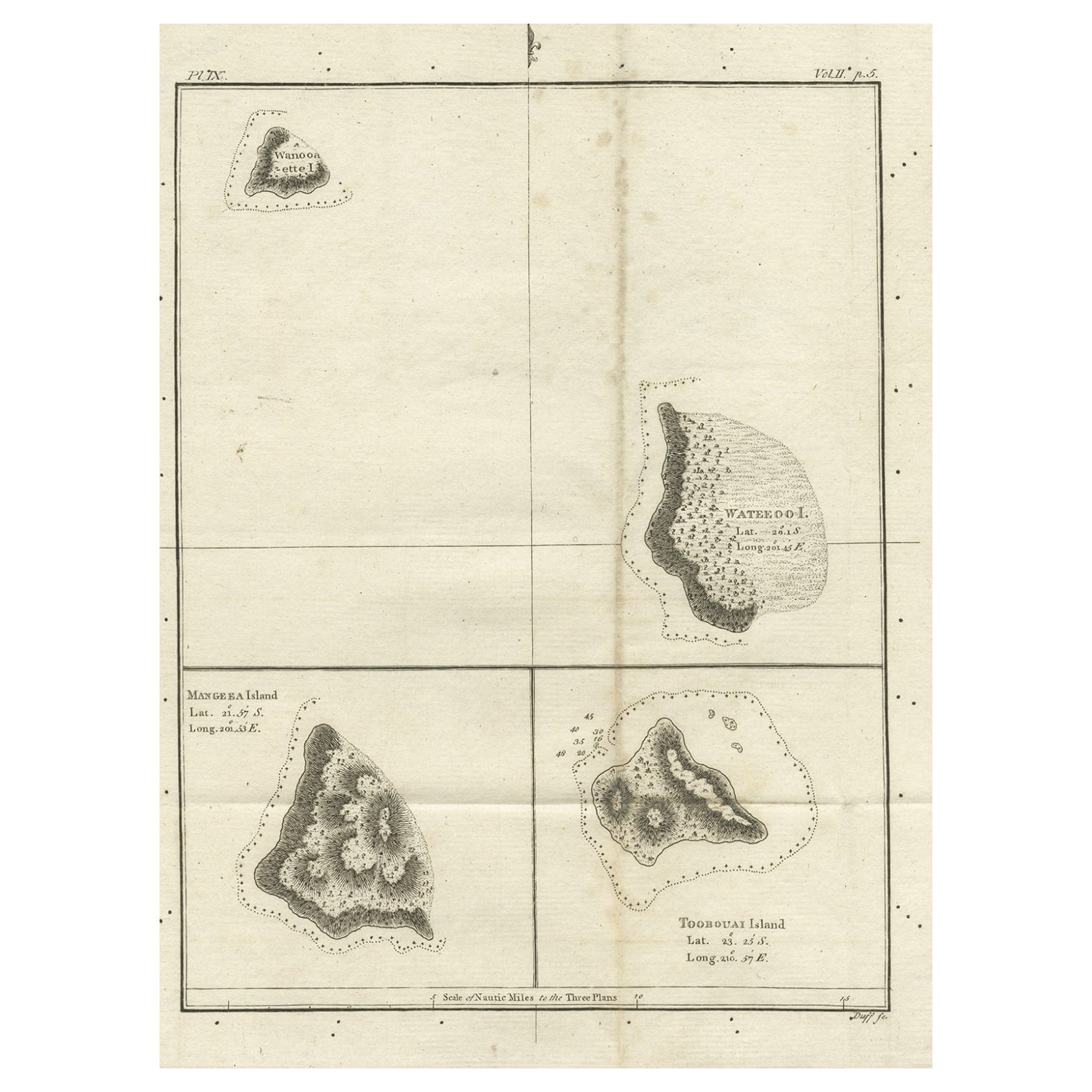
Old Map of the Cook Islands Takutea, Atiu, Mangaiac and Tubuai, Polynesia, 1781
Located in Langweer, NL
Antique map titled 'Mangeea Island, Toobouai Island (..)'. Map of three of the Cook Islands: Wanooaette [i.e. Takutea] Island, Wateeoo [i.e. Tui or Atiu] ...
Category
Antique 18th Century Maps
Materials
Paper
$124 Sale Price
20% Off
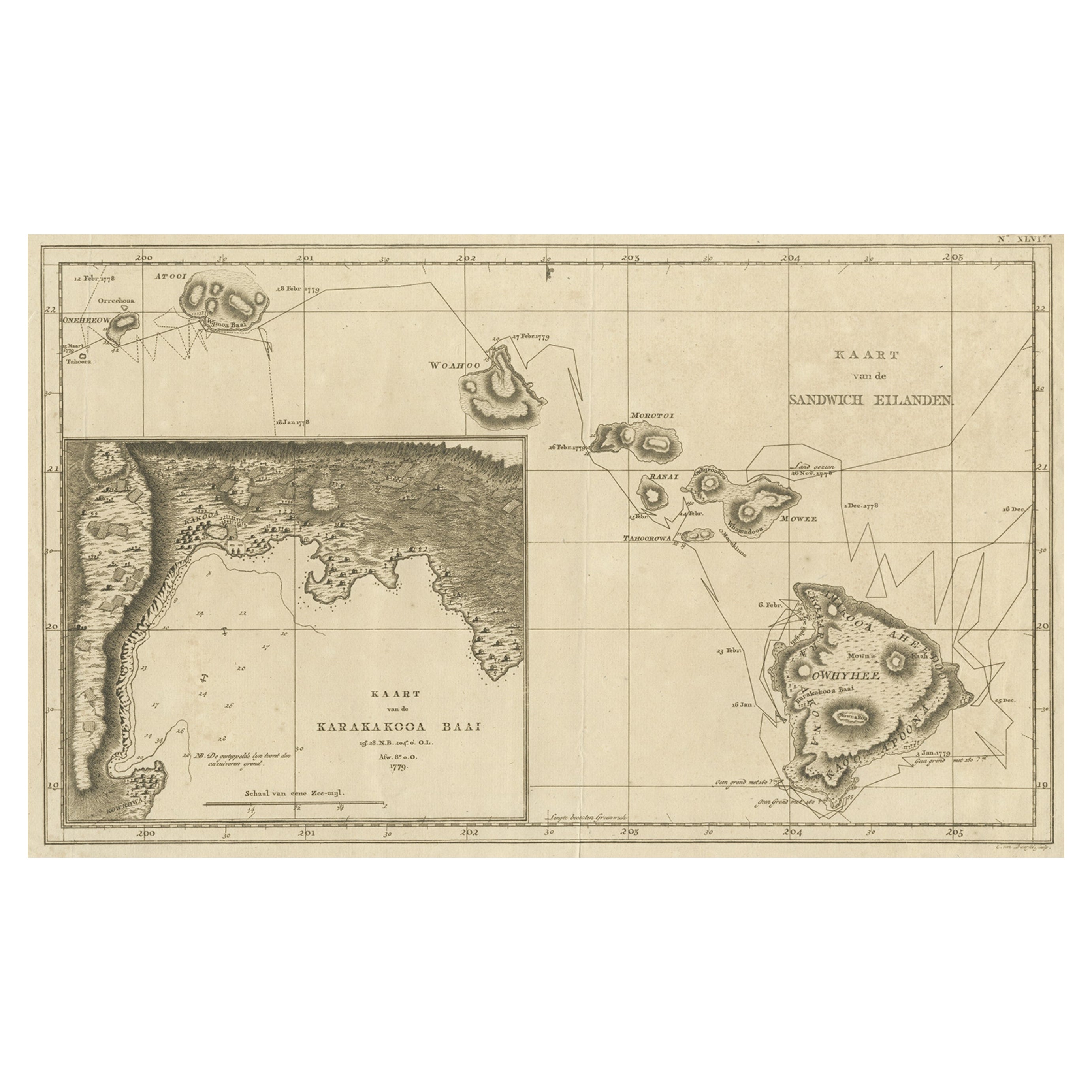
Map of the Hawaiian Islands with a Large Inset of Karakakooa Bay, 1803
Located in Langweer, NL
Antique map titled 'Kaart van de Sandwich Eilanden'.
Map of the Hawaiian Islands with a large inset of Karakakooa Bay, including soundings and anchorages. Originates from 'Reizen R...
Category
Antique Early 1800s Maps
Materials
Paper
$2,157 Sale Price
20% Off
Free Shipping
Antique Map of the Friendly Islands by Cook, 1803
Located in Langweer, NL
Antique map Friendly Islands titled 'Kaart van de Vrienden Eilanden'. Antique map of the Friendly Islands depicting Rotterdam or Anamocka, Middelburg or Eaoowe and Amsterdam or Tonga...
Category
Antique 19th Century Maps
Materials
Paper

Antique Map of Quinam and the Côn ?ao Islands by Sayer, 1778
Located in Langweer, NL
Antique map titled 'A Chart of a part of the Coast of Cochinchina' and 'Plan of Pulo Condor'. Two maps on one sheet. The upper map shows part of the coast of Cochinchina from Cham Co...
Category
Antique 18th Century Maps
Materials
Paper

$316 Sale Price
20% Off
You May Also Like
Map Of The Island Of Cuba - Guillaume Thomas Raynal (1711-1796)
Located in Porto, PT
This historical map of the Island of Cuba was produced in the late 18th century and is taken from an edition of “Atlas de toutes les parties connues du globe terrestre” by the French...
Category
Antique 18th Century Prints
Materials
Glass, Paper

Original Antique Map of US Possessions In The Pacific Ocean, C.1900
Located in St Annes, Lancashire
Fabulous map of US possessions in the Pacific Ocean
Original color.
Engraved and printed by the George F. Cram Company, Indianapolis.
Published, C.1900.
Unframed.
Free shipping.
Category
Antique 1890s American Maps
Materials
Paper

St. Christophe
St. Kitts
Island: An 18th Century Hand-colored Map by Bellin
By Jacques-Nicolas Bellin
Located in Alamo, CA
Jacques Bellin's copper-plate map of the Caribbean island of Saint Kitts entitled "Carte De De l'Isle St. Christophe Pour servir á l'Histoire Genle. des V...
Category
Antique Mid-18th Century French Maps
Materials
Paper

Original Antique Map of South America. C.1780
Located in St Annes, Lancashire
Great map of South America
Copper-plate engraving
Published C.1780
Two small worm holes to left side of map
Unframed.
Category
Antique Early 1800s English Georgian Maps
Materials
Paper

Captain Cook
s Exploration of Tahiti 18th C. Hand-Colored Map by Bellin
By Jacques-Nicolas Bellin
Located in Alamo, CA
This beautiful 18th century hand-colored copper plate engraved map is entitled "Carte de l'Isle de Taiti, par le Lieutenant J. Cook" was created by Jacques Nicolas Bellin and publish...
Category
Antique Mid-18th Century French Maps
Materials
Paper

Original Antique Map of Hawaii And Adjacent Islands. C.1900
Located in St Annes, Lancashire
Fabulous map of Hawaii. With a vignette of Honolulu
Original color.
Engraved and printed by the George F. Cram Company, Indianapolis.
Published, C.1900.
Unframed.
Free shipping.
Category
Antique 1890s American Maps
Materials
Paper

More Ways To Browse
Persian Maps
Afghanistan Antique Map
Antique Furniture Delaware
Antique Furniture Wisconsin
Antique Map By Coronelli
Antique Map Iceland
Cyprus Antique Maps
John Speed Maps
M Howard
Used Office Furniture Michigan
Antique Geological Maps
Antique Manitoba
Australian Colonial
Bengal Map
Stanford Furniture
Tennessee Antique Furniture
Used Furniture Alabama
Used Office Furniture Maine