Want more images or videos?
Request additional images or videos from the seller
1 of 10
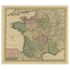
Provence – Antique Hand-Coloured Map of Southern France Region, c.1740
Price:$478.69
$682.14List Price
About the Item
- Dimensions:Height: 19.49 in (49.5 cm)Width: 23.23 in (59 cm)Depth: 0.01 in (0.2 mm)
- Materials and Techniques:Paper,Engraved
- Place of Origin:
- Period:1740-1749
- Date of Manufacture:circa 1740
- Condition:Good condition overall. Original hand colour still fresh. Blank margins lightly foxed with a few small marginal tears, none affecting the engraved image and easily backed if desired. Plate impression strong, paper stable, and image area clean.
- Seller Location:Langweer, NL
- Reference Number:Seller: BG-14168-11stDibs: LU3054347806342
About the Seller
5.0
Recognized Seller
These prestigious sellers are industry leaders and represent the highest echelon for item quality and design.
Platinum Seller
Premium sellers with a 4.7+ rating and 24-hour response times
Established in 2009
1stDibs seller since 2017
2,793 sales on 1stDibs
Authenticity Guarantee
In the unlikely event there’s an issue with an item’s authenticity, contact us within 1 year for a full refund. DetailsMoney-Back Guarantee
If your item is not as described, is damaged in transit, or does not arrive, contact us within 7 days for a full refund. Details24-Hour Cancellation
You have a 24-hour grace period in which to reconsider your purchase, with no questions asked.Vetted Professional Sellers
Our world-class sellers must adhere to strict standards for service and quality, maintaining the integrity of our listings.Price-Match Guarantee
If you find that a seller listed the same item for a lower price elsewhere, we’ll match it.Trusted Global Delivery
Our best-in-class carrier network provides specialized shipping options worldwide, including custom delivery.You May Also Like
18th Century Map of French Pyrenees Region of France
Located in Haddonfield, NJ
An antique map titled "Principatus Benearnia, La Principaute De Bearn" created by the renowned Dutch cartographer Willem Janszoon Blaeu.
It depicts the Principality of Bearn, a histo...
Category
Antique 1880s Danish Baroque Maps
Materials
Wood, Paper

Small Antique Baedeker
s South Eastern France Guide Book, Provence, Travel Maps
Located in Hele, Devon, GB
This is a delightful antique edition of Baedeker's South Eastern France guide book, complete with superb fold-out maps, centre-fold maps and informative text. A bound and intact late...
Category
Early 20th Century British Late Victorian Books
Materials
Paper
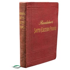
$546
H 6.3 in W 4.34 in D 0.99 in
Original Antique Map of the American State of Michigan ( Southern Part ), 1903
Located in St Annes, Lancashire
Antique map of Michigan ( Southern part )
Published By A & C Black. 1903
Original colour
Good condition
Unframed.
Free shipping
Category
Antique Early 1900s English Maps
Materials
Paper

$49
Free Shipping
H 16.25 in W 11.5 in D 0.07 in
Original Antique Map of the American State of Illinois ( Southern Part ), 1903
Located in St Annes, Lancashire
Antique map of Illinois ( Southern part )
Published By A & C Black. 1903
Original colour
Good condition
Unframed.
Free shipping
Category
Antique Early 1900s English Maps
Materials
Paper

$49
Free Shipping
H 11.5 in W 16.25 in D 0.07 in
Original Antique Map of the American State of Missouri ( Southern part ), 1903
Located in St Annes, Lancashire
Antique map of Missouri ( Southern Part )
Published By A & C Black. 1903
Original colour
Good condition
Unframed.
Free shipping
Category
Antique Early 1900s English Maps
Materials
Paper

$49
Free Shipping
H 11.5 in W 16.25 in D 0.07 in
Original Antique Map of the American State of Ohio ( Southern Part ), 1903
Located in St Annes, Lancashire
Antique map of Ohio ( Southern part )
Published By A & C Black. 1903
Original colour
Good condition
Unframed.
Free shipping
Category
Antique Early 1900s English Maps
Materials
Paper

$49
Free Shipping
H 11.5 in W 16.25 in D 0.07 in
Original Antique Map of the American State of California ( Southern Part ), 1903
Located in St Annes, Lancashire
Antique map of California ( Southern part )
Published By A & C Black. 1903
Original colour
Good condition
Unframed.
Free shipping
Category
Antique Early 1900s English Maps
Materials
Paper

$49
Free Shipping
H 11.5 in W 16.25 in D 0.07 in
Large Original Antique Map of New York State( Southern ), USA, C.1900
Located in St Annes, Lancashire
Fabulous map of Southern New York . With a vignette of Lower Manhattan
Original color.
Engraved and printed by the George F. Cram Company, Indianapolis.
Published, C.1900.
Unfram...
Category
Antique 1890s American Maps
Materials
Paper

$90
Free Shipping
H 15 in W 22 in D 0.07 in
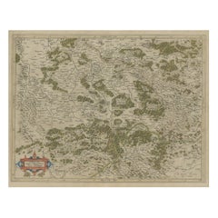
1594 Maurice Bouguereau Map of the Region Limoges, France, Ric0015
Located in Norton, MA
1594 Maurice Bouguereau map of the region Limoges, France, entitled
"Totivs Lemovici et Confinium Pro Uinciarum Quantum ad Dioecefin Lemo Uicenfen Fpectant,"
Hand Colored
Ric0015
Jean IV Le Clerc...
Category
Antique 16th Century Dutch Maps
Materials
Paper

$2,425
H 15.36 in W 21.26 in D 0.4 in
Original Antique Map of the American State of New York ( Southern Part ) 1903
Located in St Annes, Lancashire
Antique map of New York ( Southern Part )
Published By A & C Black. 1903
Original colour
Good condition
Unframed.
Free shipping
Category
Antique Early 1900s English Maps
Materials
Paper

$49
Free Shipping
H 16.25 in W 11.5 in D 0.07 in
More From This Seller
View AllAntique Map of the Southern Lorraine Region by Mercator, c.1625
By Gerard Mercator
Located in Langweer, NL
Antique map titled 'Lotharingiae Ducatus'. Old map of the southern portion of the Lorraine region, France. Lorraine is a cultural and historical region in north-eastern France, now l...
Category
Antique 17th Century Maps
Materials
Paper
Antique Map of the Region of Bavaria and Austria by Tirion, c.1740
Located in Langweer, NL
Antique map titled 'Carte des environs de Batavia - Kaart van de Buitenstreken van Batavia'. Map of the Batavia area (Jakarta) in Indonesia. With cartouche, scale and compass rose. P...
Category
Antique 18th Century Maps
Materials
Paper

Antique Map of France by Tirion, c.1740
Located in Langweer, NL
Antique map titled 'Nieuwe Kaart van Frankryk.' - Attractive detailed map showing France. Title in block-style cartouche with a simple compass rose. Source unknown, to be determined....
Category
Antique 18th Century Maps
Materials
Paper
$430 Sale Price
20% Off
Antique Map of the Region of Fréjus, France
Located in Langweer, NL
Title: "Golf de Fréjus"
Description: This antique map, titled "Golf de Fréjus," is an original depiction of the region of Fréjus, France. It is part of the work "Le Petit Atlas Mari...
Category
Antique Mid-18th Century Maps
Materials
Paper
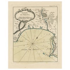
$284 Sale Price
30% Off
Antique Map of the Region of Martigues, France
Located in Langweer, NL
Title: "Etang de Martigues et Environs: Antique Map of the Martigues Region, France"
Description: This antique map, titled "Etang de Martigue et Environs," offers a detailed view of...
Category
Antique Mid-18th Century Maps
Materials
Paper
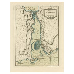
$325 Sale Price
20% Off
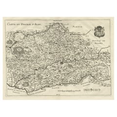
Original Old Copper Engraved Map of the Region of Albi, Southern France, 1663
Located in Langweer, NL
Antique map titled 'Carte du Diocese d'Alby'.
Original antique map of the region of Albi in Southern France. This map originates from 'Topographia Galliae dat is eene algemeene e...
Category
Antique 1660s Maps
Materials
Paper