Want more images or videos?
Request additional images or videos from the seller
1 of 10
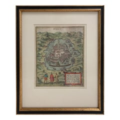
Rare 1572 Map of Ancient Rome with Monuments by Ligorio, Braun
Hogenberg
Price:$1,735.86
$1,819.32List Price
About the Item
- Dimensions:Height: 16.62 in (42.2 cm)Width: 21.86 in (55.5 cm)Depth: 0.01 in (0.2 mm)
- Materials and Techniques:Paper,Engraved
- Place of Origin:
- Period:
- Date of Manufacture:1572
- Condition:Condition: very good condition with vivid hand-coloring and crisp engraving. Margins are clean and the map is free from significant imperfections. French text on Reverse. Study the images carefully.
- Seller Location:Langweer, NL
- Reference Number:Seller: BHZ127051stDibs: LU3054343448222
About the Seller
5.0
Recognized Seller
These prestigious sellers are industry leaders and represent the highest echelon for item quality and design.
Platinum Seller
Premium sellers with a 4.7+ rating and 24-hour response times
Established in 2009
1stDibs seller since 2017
2,819 sales on 1stDibs
Typical response time: 1 hour
Authenticity Guarantee
In the unlikely event there’s an issue with an item’s authenticity, contact us within 1 year for a full refund. DetailsMoney-Back Guarantee
If your item is not as described, is damaged in transit, or does not arrive, contact us within 7 days for a full refund. Details24-Hour Cancellation
You have a 24-hour grace period in which to reconsider your purchase, with no questions asked.Vetted Professional Sellers
Our world-class sellers must adhere to strict standards for service and quality, maintaining the integrity of our listings.Price-Match Guarantee
If you find that a seller listed the same item for a lower price elsewhere, we’ll match it.Trusted Global Delivery
Our best-in-class carrier network provides specialized shipping options worldwide, including custom delivery.You May Also Like
1597 German Map of Alexandria by Georg Braun and Frans Hogenberg
By Georg Braun and Frans Hogenberg
Located in Chapel Hill, NC
1597 Map of Alexandria by Georg Braun and Frans Hogenberg, Germany. From "Civitas Orbis Terrarum", part 2, published in Cologne by Bertram Buchholz. Printed in 2 parts. Title: "Alexa...
Category
Antique 16th Century German Renaissance Maps
Materials
Paper

$480 Sale Price
20% Off
H 22.25 in W 17.75 in D 1 in
Mexico City by Braun
Hogenberg c. 1590
By Georg Braun and Frans Hogenberg
Located in Stamford, CT
Mexico by Braun & Hogenberg c. 1590
Category
Antique Mid-19th Century European Spanish Colonial Maps
Materials
Glass, Wood, Paper
Monument à Victor-Emmanuel Souvenir Building Vintage, Rome Italy, 1960s
Located in Nuernberg, DE
A 1960s souvenir building architectural model. Some wear with a nice patina, but this is old-age. Made of metal. A beautiful nice desktop item or just a display item in your collecti...
Category
Vintage 1960s Italian Historical Memorabilia
Materials
Metal
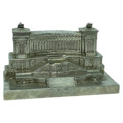
$160
H 3.13 in W 5.25 in D 3 in
Set 5, Ancient Rome, Ancient Greece, Lost Worlds, Middle Ages, Elizab, World
Located in valatie, NY
Set of 5 Books: Ancient Rome, Ancient Greece, Lost Worlds, Middle Ages, Elizabethan World. New York: American Heritage Publishing Co. Ancient Rome: in an age when Latin has become ra...
Category
Vintage 1960s American Books
Materials
Paper
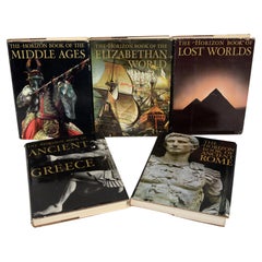
$225 / set
H 12.25 in W 9.25 in D 1.25 in
Original Antique Map of Ancient Greece, Achaia, Corinth, 1786
Located in St Annes, Lancashire
Great map of Ancient Greece. Showing the region of Thessaly, including Mount Olympus
Drawn by J.D. Barbie Du Bocage
Copper plate engraving by P.F Tardieu
Original hand color...
Category
Antique 1780s French Other Maps
Materials
Paper

$35
Free Shipping
H 10 in W 14 in D 0.07 in
Original Antique Map of Ancient Greece- Boeotia, Thebes, 1787
Located in St Annes, Lancashire
Great map of Ancient Greece. Showing the region of Boeotia, including Thebes
Drawn by J.D. Barbie Du Bocage
Copper plate engraving by P.F T...
Category
Antique 1780s French Other Maps
Materials
Paper

$35
Free Shipping
H 10 in W 14 in D 0.07 in
Map of the Kingdom of Sardinia and Part of the Kingdom of Genoa, Rome
By Giovanni Maria Cassini
Located in Hamilton, Ontario
18th century map by Italian engraver Giovanni Maria Cassini (Italy 1745-1824). Map of Part of the Kingdom of Sardinia and Part of the Kingdom of Genoa: Rome. This is a hand colored a...
Category
Antique 18th Century Italian Maps
Materials
Paper

$795 Sale Price
36% Off
H 20.75 in W 25.25 in D 0.1 in
Original Antique Map or City Plan of Rome, Italy. Circa 1835
Located in St Annes, Lancashire
Nice map of Rome
Drawn and engraved by J.Dower
Published by Orr & Smith. C.1835
Unframed.
Free shipping
Category
Antique 1830s English Maps
Materials
Paper

$60
Free Shipping
H 9.25 in W 12.25 in D 0.07 in
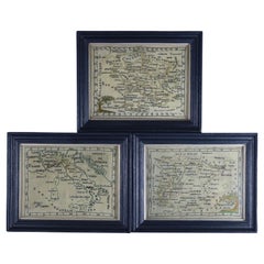
Rare Set of 3 Map Samplers by A Charles. Italy, Spain
France
Located in Chelmsford, Essex
Set of 3 Map Samplers by A Charles. All depict countries, cities, seas and landmarks of the respective countries. The first entitled, 'SPAIN and PORTUGAL'. The second, 'MAP OF FRANCE...
Category
Antique Early 19th Century English Tapestries
Materials
Linen
Rare and Early Plaster Relief Map of Adirondack Mountains by F J H Merrill
By P.F. Howells, E. W. Merrill
Located in Buffalo, NY
Rare and Early Monumental Plaster Relief Map of Adirondack Mountains by The University of the State of New York, New York State Museum..F J H Merrill director,,,modeled by Howell's ...
Category
Vintage 1910s American Industrial Maps
Materials
Plaster, Wood
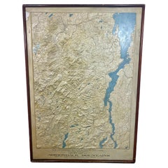
$3,200
H 63 in W 44 in D 5 in
More From This Seller
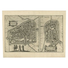
View AllAntique Map of Sneek, Dokkum, Sloten and IJlst by Hogenberg, c.1572
Located in Langweer, NL
Antique map titled 'Provincie Friesland - Gemeente Sloten'. Map of the township of Sloten, Friesland. This map originates from 'Gemeente-Atlas van Nederland' by J. Kuyper. Artists an...
Category
Antique 19th Century Maps
Materials
Paper
Antique Map of Douai
France
by Braun
Hogenberg, circa 1575
Located in Langweer, NL
Beautiful map in excellent condition. This map depicts the city of Douai (France) and originates from 'Civitates Orbis Terrarum'.
Category
Antique 16th Century Maps
Materials
Paper

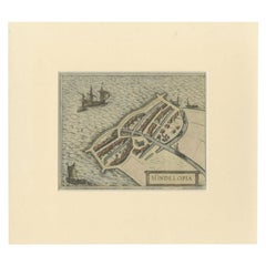
Antique Map of the City of Hindeloopen by Braun
Hogenberg, c.1598
Located in Langweer, NL
Antique map titled 'Hindelopia'. Original antique map of the city of Hindeloopen, Friesland, the Netherlands. Originally published on one sheet together with other Frisian cities, trimmed. This print originates from the town atlas by Braun and Hogenberg...
Category
Antique 16th Century Maps
Materials
Paper
Antique Map of the City of Dordrecht by Braun
Hogenberg, c.1581
Located in Langweer, NL
Antique map titled 'Dordrecht'. Map of the city of Dordrecht, the Netherlands. Bird's-eye plan view of the city, with many ships and two coats of arms in upper corners. This map orig...
Category
Antique 16th Century Maps
Materials
Paper
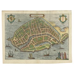
$402 Sale Price
20% Off
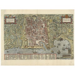
Palermo – 1620 Braun
Hogenberg Bird’s-Eye Map of Palermo, Sicily
Located in Langweer, NL
Palermo – 1620 Braun & Hogenberg Bird’s-Eye Map of Palermo, Sicily
This beautifully detailed bird’s-eye view of Palermo, Sicily, was created by Georg Braun and Frans Hogenberg aro...
Category
Antique 1620s Maps
Materials
Paper
Antique Map of the City of Leeuwarden and Franeker by Braun
Hogenberg, 1580
Located in Langweer, NL
Antique map titled 'Lewardum Occidentlis Frisiae Opp: 1580, Franicher Nobiliu hominum, in Frisia Occidentali, ut plurimum saedes'. This sheet contains two very detailed bird’s-eye pl...
Category
Antique 16th Century Maps
Materials
Paper
Still Thinking About These?
All Recently ViewedMore Ways To Browse
Antique Forum
16th Century German
Green Persian Rug
50 X 50 Coffee Table
Spanish Baroque Furniture
Couch Console
Vintage Burn
Sterling Silver Flatware Service For 12
Antique Dining Tables With Leaves
Decorative Wall Panels
Frank Lloyd Wright For Cassina
Natural Curved
Spanish Wool Rug
Leather Pouf And Ottomans
Low Side Tables
Set Of Four Italian Dining Chairs
Silk Runner Carpet
18th Century Blue And White Porcelain