Items Similar to Rare 1670 Map of Tartary by Richard Blome after Sanson, Hand-colored Engraving


Want more images or videos?
Request additional images or videos from the seller
1 of 10
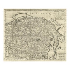
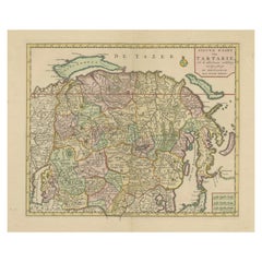
Rare 1670 Map of Tartary by Richard Blome after Sanson, Hand-colored Engraving
$691.12
£514.79
€580
CA$951.73
A$1,035.94
CHF 548.91
MX$12,458.74
NOK 6,979.21
SEK 6,395.68
DKK 4,419.22
About the Item
Rare 1670 Map of Tartary by Richard Blome after Sanson, hand-colored engraving
This striking and highly decorative map, titled *A Generall Mapp of the Kingdome of Tartaria*, was published circa 1670 by Richard Blome, one of the most ambitious English map and book publishers of the late 17th century. This hand-colored copperplate engraving presents the vast northern and central Asian region then known as Tartary—a term used in early European cartography to describe an expansive and vaguely defined area stretching from Russia and the Caspian Sea to China and the Pacific Ocean.
The map is based on the cartography of Nicolas Sanson, the Royal Geographer to the French King, and was engraved by Thomas Burnford. Sanson’s influence is seen in the careful geographical detailing of mountain ranges, rivers, deserts (notably the Desert of Bel), and the delineation of numerous regions and tribal kingdoms such as Samojedia, Cathay, Tangut, Karakathay, and Kithia. The Caspian Sea and the Kingdom of China are clearly marked, as are the borders of the Great Mogol Empire and Persia to the south.
Visually, the map is enhanced by an elaborate coat of arms and dedication to Roger Vaughan of Herefordshire, framed by garlands and flanked by two birds—an example of the richly ornamental style typical of Blome’s maps. This dedication emphasizes the subscription-based model Blome used, often securing patronage in return for name placement and personalized embellishment.
This example retains strong original hand-coloring, with a distinct palette delineating major regions and natural features. The plate measures approximately 15.4 x 10.2 inches (39.1 x 25.9 cm), and was originally issued in Blome’s *Geographical Description of the Four Parts of the World*.
A rare and collectible early English map with historical importance and visual appeal, ideal for collectors of antique cartography or maps of Asia and Russia.
Condition Report:
Very good condition. Minor toning in blank margins. Close original side margins (approx. 1/8") as issued. Hand-coloring is well-preserved. Plate mark visible. No tears or repairs noted. Blank verso.
Framing Tips:
Frame with a classic gold or dark wood moulding. Use a light cream or ivory archival mat to enhance the map’s coloring. A float mount with UV-protective glass is ideal to showcase the plate edges and preserve this 17th-century treasure.
- Dimensions:Height: 13 in (33 cm)Width: 15.75 in (40 cm)Depth: 0.01 in (0.2 mm)
- Materials and Techniques:Paper,Engraved
- Period:1670-1679
- Date of Manufacture:1670
- Condition:Very good condition. Minor toning in blank margins. Close original side margins (approx. 1/8") as issued. Hand-coloring is well-preserved. Plate mark visible. No tears or repairs noted. Blank verso.
- Seller Location:Langweer, NL
- Reference Number:Seller: BG-140641stDibs: LU3054345121262
About the Seller
5.0
Recognized Seller
These prestigious sellers are industry leaders and represent the highest echelon for item quality and design.
Platinum Seller
Premium sellers with a 4.7+ rating and 24-hour response times
Established in 2009
1stDibs seller since 2017
2,824 sales on 1stDibs
Typical response time: 1 hour
- ShippingRetrieving quote...Shipping from: Langweer, Netherlands
- Return Policy
More From This Seller
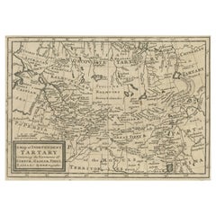
View AllAntique Map of Tartary, Siberia
China – Tirion, Amsterdam c.1730
Located in Langweer, NL
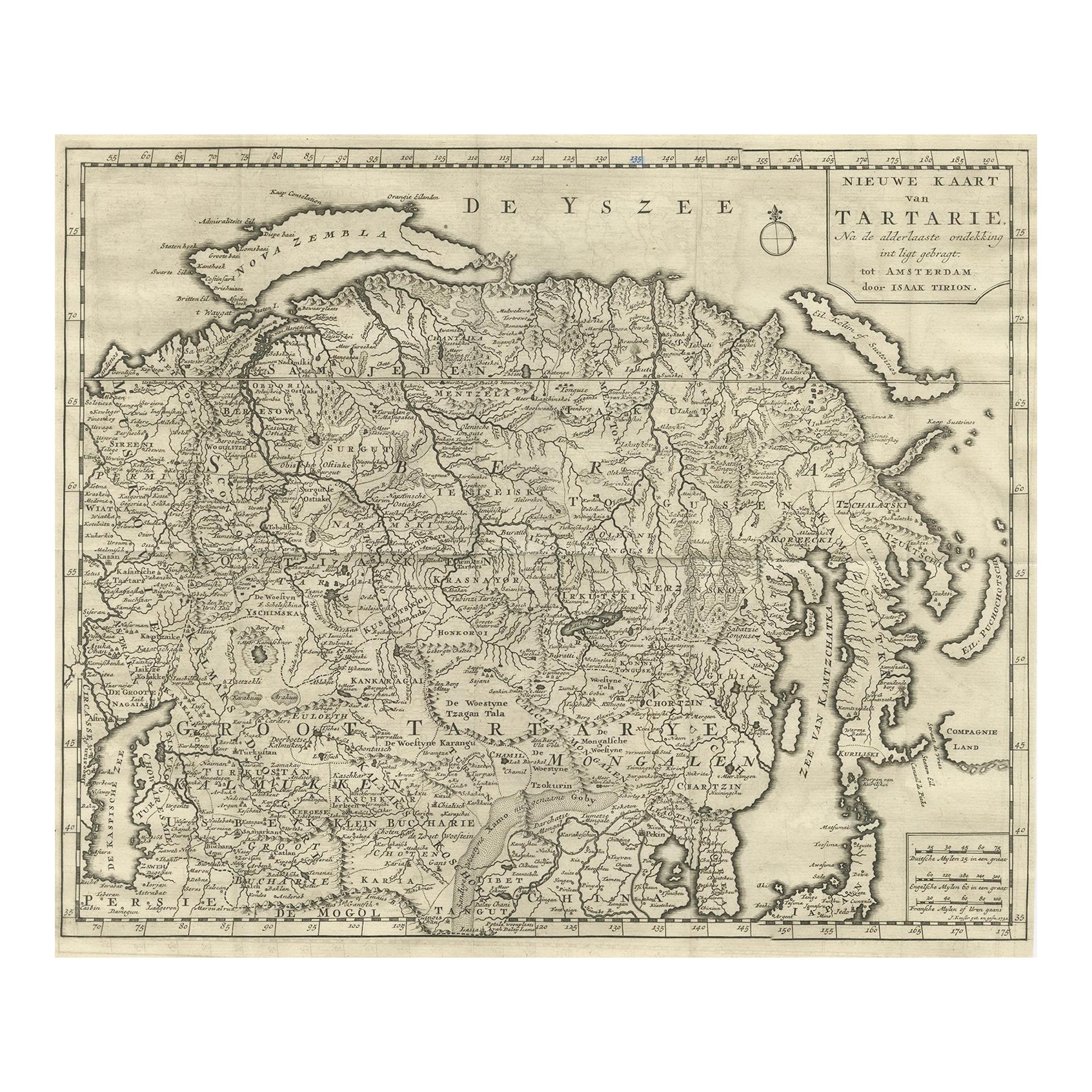
Antique Map of Tartary – “Nieuwe Kaart van Tartarie” by Isaak Tirion, Amsterdam c.1730
This finely engraved 18th-century map titled “Nieuwe Kaart van Tartarie” (New Map of Tartary) ...
Category
Antique Mid-18th Century Dutch Maps
Materials
Paper
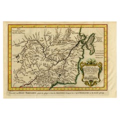
Old Map of Tartary with Persia, Siberia, the Mogul Territories
China, ca.1717
Located in Langweer, NL
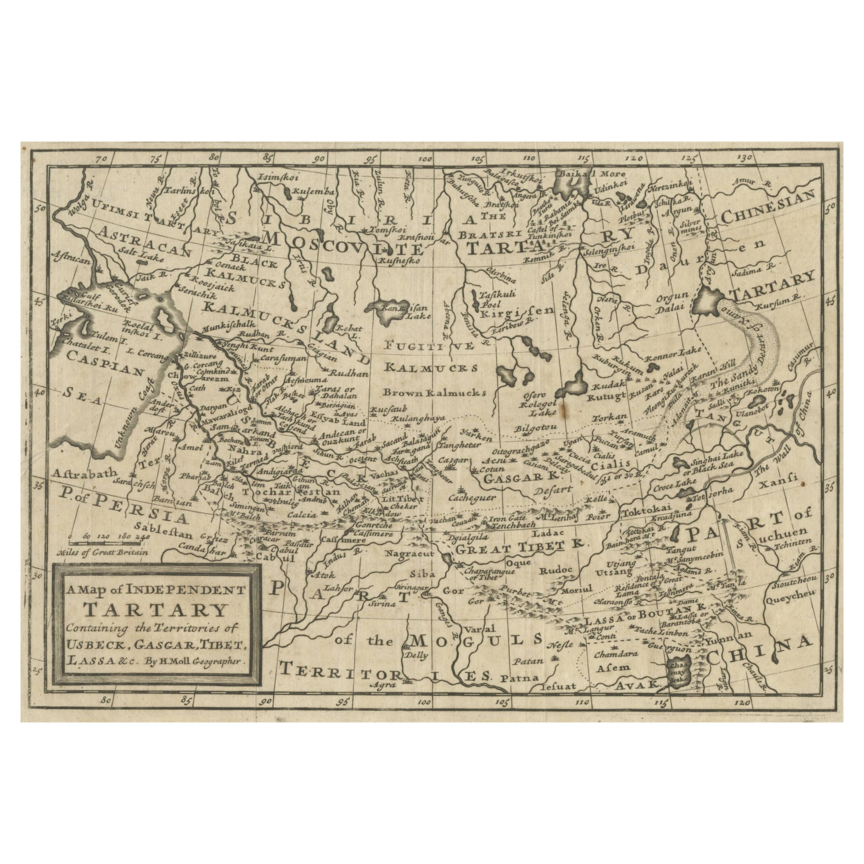
Antique map titled 'A Map of Independent Tartary, containing the territories of Usbeck, Gasgar, Tibet, Lassa & c'.
Old map depicting east of the Caspian Sea with parts of Persia, Siberia, the Mogul territories and on to western China...
Category
Antique 1710s Maps
Materials
Paper
$333 Sale Price
20% Off
Antique Map of Tartary and Northeast Asia, c.1750
Located in Langweer, NL
Antique map titled 'Carte de la tartarie occidentale'. An interesting map of Tartary and northeast Asia, from Lake Baykal, Partie du Siberia in the north, Pays des Kalkas at the cent...
Category
Antique 18th Century Maps
Materials
Paper

$123 Sale Price
20% Off
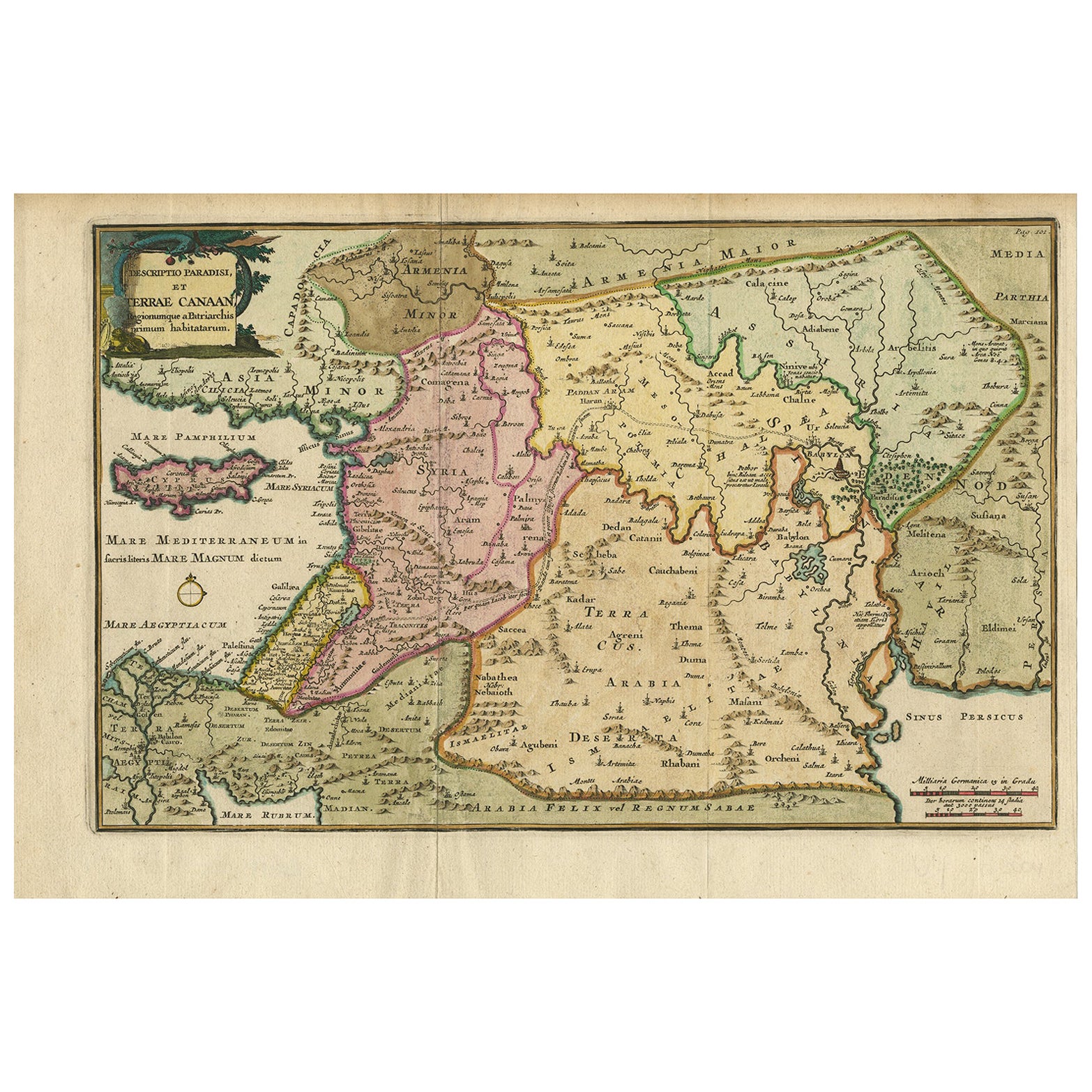
Antique Map of the Holy Land and Paradise – Terrae Canaan Map, c.1720
Located in Langweer, NL
Antique Map of the Holy Land and Paradise by François Halma, c.1720
Beautiful early 18th-century hand-colored map of the Middle East extending from the Mediterranean Sea to the Pers...
Category
Antique Early 18th Century Dutch Maps
Materials
Paper

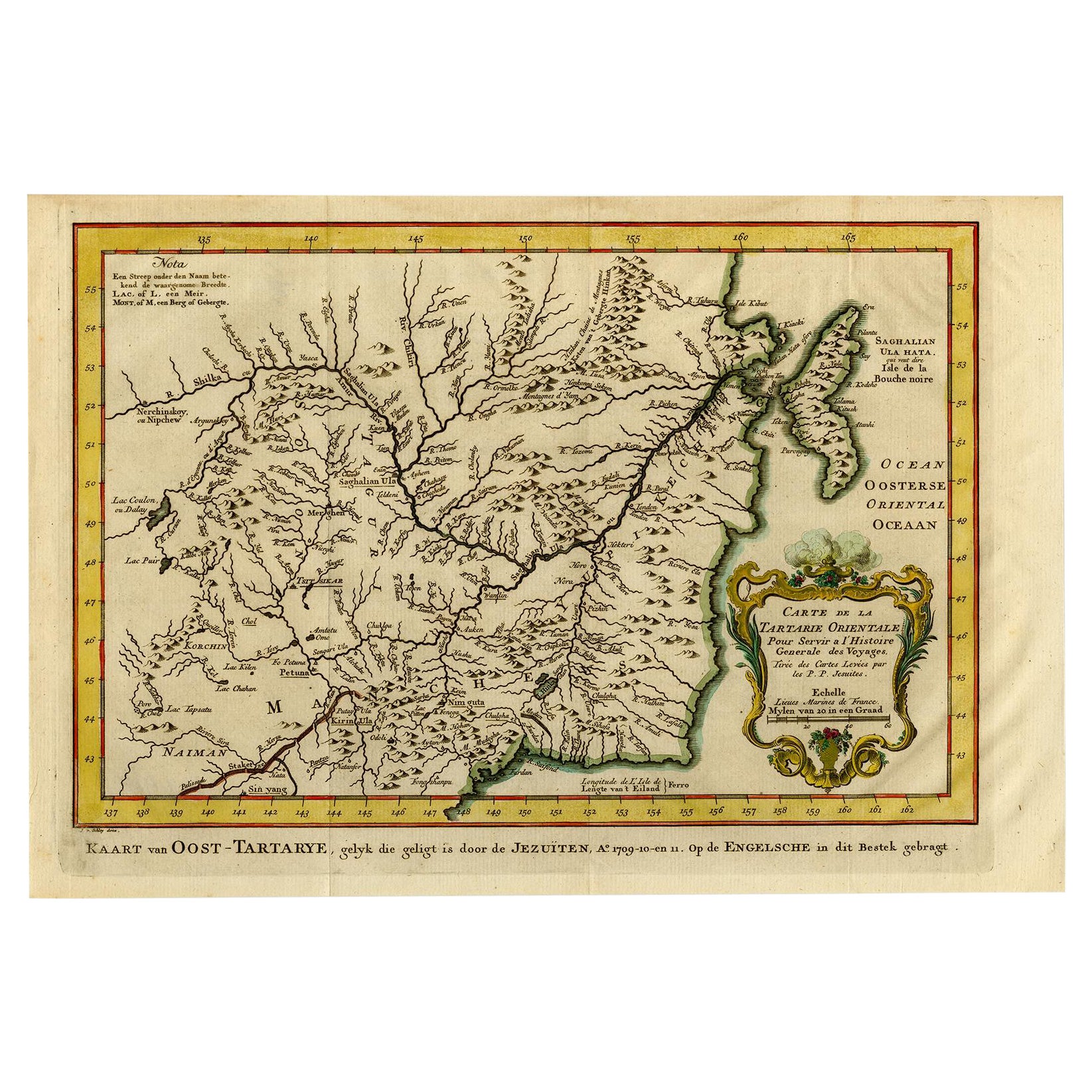
Antique Map of Eastern Tartary, now the Primorsky Krai Area, Russia, 1758
By Jakob van der Schley
Located in Langweer, NL
Antique map titled 'Carte de la Tartarie orientale.' A map of Eastern Tartary. East Tartary is an old names for the Manchu-inhabited territory extending from the River Amur to Sakhal...
Category
Antique 18th Century Maps
Materials
Paper
Map of Tartary by Isaak Tirion: Detailed Cartography of Northern Asia, ca.1740
Located in Langweer, NL
This is an antique map titled "Nieuwe Kaart van Tartarie," which translates to "New Map of Tartary." The map was created by Isaak Tirion, a prominent Dutch cartographer and publisher...
Category
Antique 1740s Maps
Materials
Paper
$629 Sale Price
20% Off
You May Also Like
"Nova Barbariae Descriptio", a 17th Century Hand-Colored Map of North Africa
By Johannes Janssonius
Located in Alamo, CA
This original attractive 17th century hand-colored map of North Africa entitled "Nova Barbariae Descriptio" by Johannes Janssonius was published in Paris in 1635. It includes the Med...
Category
Antique Mid-17th Century Dutch Maps
Materials
Paper

Map of the Russian Empire: An Original 18th Century Hand-colored Map by E. Bowen
Located in Alamo, CA
This is an original 18th century hand-colored map entitled "A New & Accurate Map of The Whole Russian Empire, As Contain'd Both In Europe and Asia, Drawn from Authentic Journals, Sur...
Category
Mid-18th Century Old Masters Landscape Prints
Materials
Engraving

Southern Greece: A Large 17th Century Hand-colored Map By Sanson and Jaillot
By Nicholas Sanson d
Abbeville
Located in Alamo, CA
This large original hand-colored copperplate engraved map of southern Greece and the Pelopponese Peninsula entitled "La Moree Et Les Isles De Zante, Cefalonie, Ste. Marie, Cerigo & C...
Category
1690s Landscape Prints
Materials
Engraving

1592 Abraham Ortelius Map "Lorraine: Lotharingiae Nova Descripti, Ric.A005
Located in Norton, MA
1592 Abraham Ortelius map entitled
"Lorraine: Lotharingiae Nova Descripti
Ric.a005
Description: Ortelius is best known for producing the atlas from which this map comes from, "...
Category
Antique 16th Century Dutch Maps
Materials
Paper

Engraving Depicting 16th Century Map of Terra Sancta
Located in Buchanan, MI
Abraham Ortelius (Flemish, 1527-1598) Terra Sancta.
Engraving depicting 16th century map of Terra Sancta. Site 15" x 19.5.
Category
Antique 18th Century and Earlier Maps
Materials
Paper

Southern
Eastern Europe: A Large 17th C. Hand-colored Map by Sanson
Jaillot
By Nicholas Sanson d
Abbeville
Located in Alamo, CA
This large hand-colored map entitled "Estats de L'Empire des Turqs en Europe, ou sont les Beglerbeglicz our Gouvernements" was originally created by Nicholas Sanson d'Abbeville and this version was published by Hubert Jaillot in "Atlas Nouveau" in Paris in 1692. It depicts the territories of the Ottoman Empire in Europe, predominantly Eastern Europe. Highlights include, the Mediterranean Sea, the Adriatic Sea, the Black Sea, the Dalmation Coast including present day Croatia, Bosnia and Herzegovina, Montenegro, Serbia, Slovenia, Italy, Greece, North Macedonia, Turkey, Romania, Hungary, Albania, Kosovo, Bulgaria, Transylvania, Moldova and southern portions of France, Switzerland, Germany, and Poland..
The map consists of two sheets joined as one along a vertical joint. The map has original hand-coloring. It is printed on antique hand-made laid, chain-linked paper with wide margins. The sheet measures 24.88" high and 38" wide. There is a central vertical joint, as issued. The map is in very good condition.
Nicholas Sanson d'Abbeville (1600-1667) was one of the greatest French cartographather of French cartography. Sanson opened his first printing business in Paris in 1638. The king recognized his skill and knowledge and made him the official geographer to the court. He eventually served two kings in this capacity. Sanson was succeeded by his sons and son...
Category
1690s Landscape Prints
Materials
Engraving

More Ways To Browse
Rare Engravings
Round Table Base
Cream Soup
Early English Silver
James Bond
Paisley Rugs and Carpets
Antique Pagoda
Black And Chrome Lounge Chair
Ceramic 1960s Italy
Vintage 1930 Dining Room Set
Antique Brass And Copper
Antique Cow
Antique Harvest
Antique Victorian Dining Tables
Environment Furniture
Italian Plastic Chairs
Made In Belgium
Black Crystal Glasses