Want more images or videos?
Request additional images or videos from the seller
1 of 10
Rare 1864 Civil War Era Map of North America with Detailed Borders
Price:$330.28
$522.18List Price
About the Item
- Dimensions:Height: 26.38 in (67 cm)Width: 18 in (45.7 cm)Depth: 0.01 in (0.2 mm)
- Materials and Techniques:
- Period:
- Date of Manufacture:1864
- Condition:The map is in good condition for its age, with light toning and minor foxing along the edges. Small tears are present at the fold lines, and right margins but there are no significant losses. The colors remain vivid, and the paper is intact.
- Seller Location:Langweer, NL
- Reference Number:Seller: BG-13952-171stDibs: LU3054345073962
About the Seller
5.0
Recognized Seller
These prestigious sellers are industry leaders and represent the highest echelon for item quality and design.
Platinum Seller
Premium sellers with a 4.7+ rating and 24-hour response times
Established in 2009
1stDibs seller since 2017
2,830 sales on 1stDibs
Typical response time: 1 hour
Authenticity Guarantee
In the unlikely event there’s an issue with an item’s authenticity, contact us within 1 year for a full refund. DetailsMoney-Back Guarantee
If your item is not as described, is damaged in transit, or does not arrive, contact us within 7 days for a full refund. Details24-Hour Cancellation
You have a 24-hour grace period in which to reconsider your purchase, with no questions asked.Vetted Professional Sellers
Our world-class sellers must adhere to strict standards for service and quality, maintaining the integrity of our listings.Price-Match Guarantee
If you find that a seller listed the same item for a lower price elsewhere, we’ll match it.Trusted Global Delivery
Our best-in-class carrier network provides specialized shipping options worldwide, including custom delivery.You May Also Like
1864 Map of North America, Antique Hand-Colored Map, by Adolphe Hippolyte Dufour
Located in Colorado Springs, CO
Offered is a map of North America entitled Amerique du Nord from 1864. This rare, separately published wall map was produced by Adolphe Hippolyte Dufour. This map includes vibrant an...
Category
Antique 1860s French Maps
Materials
Paper

$4,500
H 44.5 in W 33 in D 1.5 in
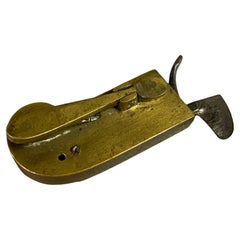
Civil War Era Brass Bodied Bloodletting Fleam
Located in New Windsor, NY
American Civil War Era brass bodied bloodletting fleam, phlebetome or scarificator. The fleam, which has many other spellings such as phleam, flew or fleame, is a very distinct surgi...
Category
Antique 1860s American High Victorian Scientific Instruments
Materials
Brass, Steel
American Hepplewhite Virginian Secretary Chest with Civil War Provenance
By George Hepplewhite
Located in Dallas, TX
PRESENTING a FANTASTIC and HISTORIC Early 19C American Hepplewhite Virginian Secretary Chest with OUTSTANDING Provenance.
This Secretary Chest was made in Virginia in the Early 19th Century, circa 1810.
It is made of cherry, walnut and maple and is most definitely in the Hepplewhite Style of the period, with it’s original Hepplewhite brass drawer pulls.
IT IS A REALLY INTRIGUING AND HISTORIC PIECE, ESPECIALLY, WHEN VIEWED IN CONTEXT WITH IT”S AMAZING PROVENANCE!
This piece was originally owned by Major William Alexander Obenchain who ‘hailed’ from the State of Virginia.
He was an engineer and was in the Virginia Corps of Engineers during the Civil War and served on General Robert E. Lee’s staff. It was acquired by him before the Civil War and we believe that this piece was on campaign with him during the War. We know for a fact that he fought at the Richmond Campaign in 1864, as we have, in our Collection, his original Field Map for that Campaign which ended the War.
It has remained in family ownership ever since.
It has come directly from the Family Estate, together with other VERY IMPORTANT items belonging to Major Obenchain and other IMPORTANT items that belonged to his wife, Eliza Calvert Hall-Obenchain. ALL these items contained in the Collection, are listed/posted individually on our Website.
The top drawer is on retractable curved side hinge supports and pulls outwards and drops to reveal a secretary and writing area.
The Bureau/Secretary Gallery has 6 drawers and 6 cubbies, a central tabernacle door with another drawer and 2 cubbies and this is flanked by 2 secret pull out compartments.
The central tabernacle door has it’s original key and working lock.
Closed, it is almost ‘flush’ like the rest of the drawers, with some very minor bowing through age.
The 3 drawers underneath are graduated in size and it ends with a serpentine shaped base and sits on four hand carved legs with original metal casters, marked ‘Universal 3’.
It has it’s original brasses and hardware throughout, save the addition to 2 contemporary replacement brass hinges to the drop down desk front, as the original hinges were broken, could not be repaired and were not supporting the weight of the drop down leaf.
Some minor repairs but not noticeable.
Otherwise, the piece is in it’s entirely, ORIGINAL condition!
What makes this piece even MORE INTRIGUING and APPEALING HISTORICALLY, are the 2 ‘historic’ circular holes on the piece:-
(1) in the back of the piece as seen in the photos. This hole is not symmetrical or fully round and appears to serve no purpose to the piece whatsoever. Sometimes, pieces have holes for wiring for lighting, put in them over the years, but this one never had such lighting or, indeed, any such explanation for this hole, AND
(2) the rear hole is replicated, in the corner portion of the bottom drawer and someone (a very long time ago) has used a tin can top, to cover the hole in the back of the drawer. The tin can top is period to the Civil War Era and is embossed “Minimum Volume 1 Pint”.
Our conclusion, is that (whilst we are, by no means ballistic experts) that these holes were created by musket balls, fired during one of the Major’s campaigns in the Civil War. It is entirely conceivable that this piece, being strapped into a covered wagon for carriage, would have been on it’s side. We are of the opinion that both holes, were caused or created by a musket ball entered the chest trough the base and back. We also believe that ‘the Major’, used what he had at his disposal on the battlefield, namely, a tin can lid to repair the hole in the drawer.
SO THIS PIECE IS A VERY SPECIAL PIECE OF US HISTORY, INDEED!
NOT ONLY IS IT AN EARLY 19th CENTURY AMERICAN PIECE, WITH A CONNECTION TO THE STATE OF VIRGINIA, THE CIVIL WAR, HISTORIC & IMPORTANT FIGURES IN THAT WAR AND IMPECCABLE PROVENANCE AND HISTORY!
IT IS TRULY UNIQUE!
William Alexander Obenchain. Born April 27, 1841 at Buchanan, Botetourt Co., Virginia.
Parents: Thomas Jefferson Obenchain and Elizabeth Ann Sweetland.
Entered VMI on July 18, 1859 as a member of the VMI (Virginia Military Institute...
Category
Antique Early 19th Century American American Classical Historical Memora...
Materials
Brass
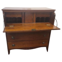
$16,000
H 44.25 in W 42.75 in D 20.25 in
University Chart “Black Map of North America
Located in Godshill, Isle of Wight
University Chart “Black Map of North America
W&A K Johnston’s Charts of Physical Maps By G W Bacon,
This is a Black Physical map of North A...
Category
Early 20th Century Industrial Maps
Materials
Linen

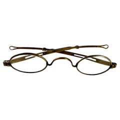
Historical Civil War Era Brass Frame Ladies Magnifying Glasses
Located in Philadelphia, PA
A delicate pair of handmade brass ladies magnifying wire rim eye glasses from the American Civil War era, circa 1860.
A unique pair of antique spectacles, cleverly designed with ext...
Category
Antique Mid-19th Century American American Classical Historical Memorabilia
Materials
Brass
1868 "Lloyd
s Topographical Railway Map of North America..." Hanging Wall Map
Located in Colorado Springs, CO
Presented is “Lloyd's Topographical Railway Map of North-America, or the United States Continent in 1900.” This map was published by J. T. Lloyd, in New York, in 1868. A large, hangi...
Category
Antique 1860s American Late Victorian Maps
Materials
Linen, Paper

$6,500
H 60 in W 67.5 in D 1 in
Large 1848 North America
Territories Map
Located in Stamford, CT
Framed 1848 S. Augustus and Mitchell, Philadelphia , PA North America and territories map.
Featuring the United States, Canada (British Territory) and Mexican Territories.
As found...
Category
Antique 1840s American American Classical Maps
Materials
Glass, Wood, Paper

Antique Civil War Era Leg Brace or Splint with Metal, Brass
Wood Construction
Located in Hamilton, Ontario
This antique Civil War era primitive leg brace or splint is unsigned, but presumed to have been made in the United States in circa 1860. The brac...
Category
Antique Mid-19th Century American Primitive Historical Memorabilia
Materials
Brass, Cut Steel

$1,795
H 37 in W 8.5 in D 5 in
"Army of the Potomac" by John Bachelder, Civil War Era Lithograph, circa 1863
Located in Colorado Springs, CO
Fully-entitled: Army of the Potomac. The Wagon Trains of the Army of the Potomac en Route from Chickahominy to James River VA. During the Seven...
Category
Antique 19th Century American Prints
Materials
Paper
$2,950
H 29.5 in W 37.5 in D 2.5 in
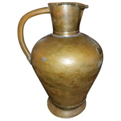
19th Century Large Civil War Era Bronze and Tin Pitcher
Located in Dallas, TX
Presenting a fabulous historic treasure of times past, namely, a 19th century large Civil War Era bronze and tin pitcher.
From circa 1850, this is an American frontier piece.
I...
Category
Antique Mid-19th Century American American Classical Pitchers
Materials
Brass, Bronze, Copper, Tin
More From This Seller
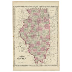
View AllRare 1864 Civil War Era Map of Illinois with Lake Michigan Detail
Located in Langweer, NL
Title: Rare 1864 Civil War Era Map of Illinois with Lake Michigan Detail
Description: This intricately detailed antique map, titled "Johnson's Illinois," was published in 1864 by Jo...
Category
Antique 1860s Maps
Materials
Paper
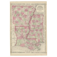
Rare 1864 Civil War Era Map of Arkansas, Mississippi, and Louisiana
Located in Langweer, NL
Title: Rare 1864 Civil War Era Map of Arkansas, Mississippi, and Louisiana
Description: This captivating antique map, titled "Johnson's Arkansas, Mississippi, and Louisiana," was pu...
Category
Antique 1860s Maps
Materials
Paper
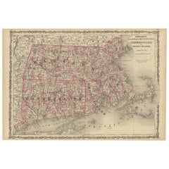
Rare 1864 Civil War Era Map of Massachusetts, Connecticut, and Rhode Island
Located in Langweer, NL
Title: Rare 1864 Civil War Era Map of Massachusetts, Connecticut, and Rhode Island
Description: This exquisite antique map, titled "Johnson's Massachusetts, Connecticut, and Rhode I...
Category
Antique 1860s Maps
Materials
Paper
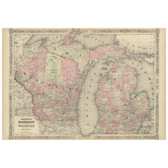
Rare 1864 Civil War Era Map of Michigan and Wisconsin with Great Lakes Detail
Located in Langweer, NL
Title: Rare 1864 Civil War Era Map of Michigan and Wisconsin with Great Lakes Detail
Description: This beautifully crafted antique map, titled "Johnson's Michigan and Wisconsin," wa...
Category
Antique 1860s Maps
Materials
Paper
Decorative 1864 Civil War Era Map of Indiana with Lake Michigan Detail
Located in Langweer, NL
Title: Rare 1864 Civil War Era Map of Indiana with Lake Michigan Detail
Description: This finely detailed antique map, titled "Johnson's Indiana," was published in 1864 by Johnson a...
Category
Antique 1860s Maps
Materials
Paper

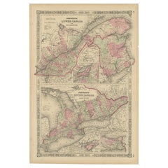
Historic 1864 Civil War Era Map of Canada with Great Lakes Detail
Located in Langweer, NL
Title: Rare 1864 Civil War Era Map of Canada with Great Lakes Detail
Description: This finely detailed antique map, titled "Johnson's Canada," was published in 1864 by Johnson and W...
Category
Antique 1860s Maps
Materials
Paper
Still Thinking About These?
All Recently ViewedMore Ways To Browse
Americana Antiques
Round Table Base
Cream Soup
Early English Silver
James Bond
Paisley Rugs and Carpets
Antique Pagoda
Black And Chrome Lounge Chair
Ceramic 1960s Italy
Vintage 1930 Dining Room Set
Antique Brass And Copper
Antique Cow
Antique Harvest
Antique Victorian Dining Tables
Environment Furniture
Italian Plastic Chairs
Made In Belgium
Black Crystal Glasses