Items Similar to Rare Antique Map of Borneo (Kalimantan), Dutch East Indies Colonial Era, 1884
Want more images or videos?
Request additional images or videos from the seller
1 of 10
Rare Antique Map of Borneo (Kalimantan), Dutch East Indies Colonial Era, 1884
$527.98
£391.27
€440
CA$721.60
A$785.52
CHF 416.95
MX$9,451.45
NOK 5,283.35
SEK 4,841.04
DKK 3,351.61
About the Item
Antique Map of Borneo Dutch East Indies Colonial Kalimantan Cartography
This decorative antique map depicts the island of Borneo in full during the late Dutch colonial period, showing the vast territory that today forms Indonesian Kalimantan together with the northern regions now belonging to Malaysia and Brunei. The map presents Borneo as one of the most important and least penetrated colonial landscapes of Southeast Asia, combining coastal navigation detail with deeply rendered interior topography.
NOTE: We do not sell this piece in a frame, but as a loose sheet.
Mountain ranges, river systems, coastal settlements, trade routes, and colonial administrative boundaries are all shown with exceptional precision. The immense river networks dominate the composition, emphasizing Borneo’s role as a territory structured by waterways rather than roads. Coastal ports, trading posts, and strategic locations are clearly marked, reflecting the economic and geopolitical interests of the Dutch colonial administration.
Original hand-applied color highlights province boundaries and coastlines, creating a refined contrast against the dense engraved topographic detail. The palette is restrained and elegant, with soft greens and neutral tones that enhance both legibility and decorative presence. The scale and vertical composition give the map strong wall power and a quiet architectural authority.
Historically, this map captures Borneo at a moment when large parts of the interior were still only partially explored and documented by Europeans. It reflects the late 19th–early 20th century phase of Dutch colonial expansion, scientific surveying, and territorial consolidation in the East Indies.
This map is highly desirable for collectors of Southeast Asian cartography, colonial history, maritime trade, ethnographic exploration, and large-format historical wall maps. It displays exceptionally well in libraries, boardrooms, studies, and curated interiors that favor strong geographic statement pieces.
Condition report
Good overall condition with light, even age toning and scattered minor foxing consistent with age. Original hand coloring remains fresh. No major tears, no heavy staining, and no losses. Clean, strong impression.
NOTE: We do not sell this piece in a frame, but as a loose sheet.
Framing tips
This tall-format map is ideally framed with soft ivory or warm light-grey museum matting and a slim dark walnut, bronze, or restrained gilt frame. UV-protective museum glass is strongly recommended. Due to the vertical composition, it works especially well as a standalone statement piece on narrower wall sections.
Technique: Color lithography
Maker: Dutch colonial cartographic publication, Amsterdam, late 19th–early 20th century
- Dimensions:Height: 19.1 in (48.5 cm)Width: 15.36 in (39 cm)Depth: 0.01 in (0.2 mm)
- Materials and Techniques:
- Place of Origin:
- Period:
- Date of Manufacture:1884
- Condition:Good overall condition with light, even age toning and scattered minor foxing consistent with age. Original hand coloring remains fresh. No major tears, no heavy staining, and no losses. Clean, strong impression.
- Seller Location:Langweer, NL
- Reference Number:Seller: BG-14172-61stDibs: LU3054347872372
About the Seller
5.0
Recognized Seller
These prestigious sellers are industry leaders and represent the highest echelon for item quality and design.
Platinum Seller
Premium sellers with a 4.7+ rating and 24-hour response times
Established in 2009
1stDibs seller since 2017
2,816 sales on 1stDibs
Typical response time: 1 hour
- ShippingRetrieving quote...Shipping from: Langweer, Netherlands
- Return Policy
More From This Seller
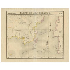
View AllAntique Map of Southeast Borneo by P.M.G. Vandermaelen, 1827
Located in Langweer, NL
Striking and highly detailed unusual large-format fine example of Vandermaelen's map covering part of the south-eastern part of Borneo and western tip of Sulawesi. The map provides g...
Category
Antique Early 19th Century Maps
Materials
Paper
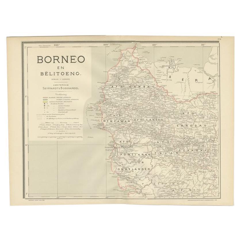
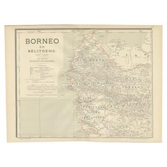
Antique Map of West Kalimantan, Borneo, Indonesia, 1900
Located in Langweer, NL
Antique map titled 'Borneo en Belitoeng'. Old map of West Kalimantan, Borneo. This map originates from 'Atlas van Nederlandsch Oost- en West-Indië' by I. Dornseiffen.
Artists and...
Category
20th Century Maps
Materials
Paper
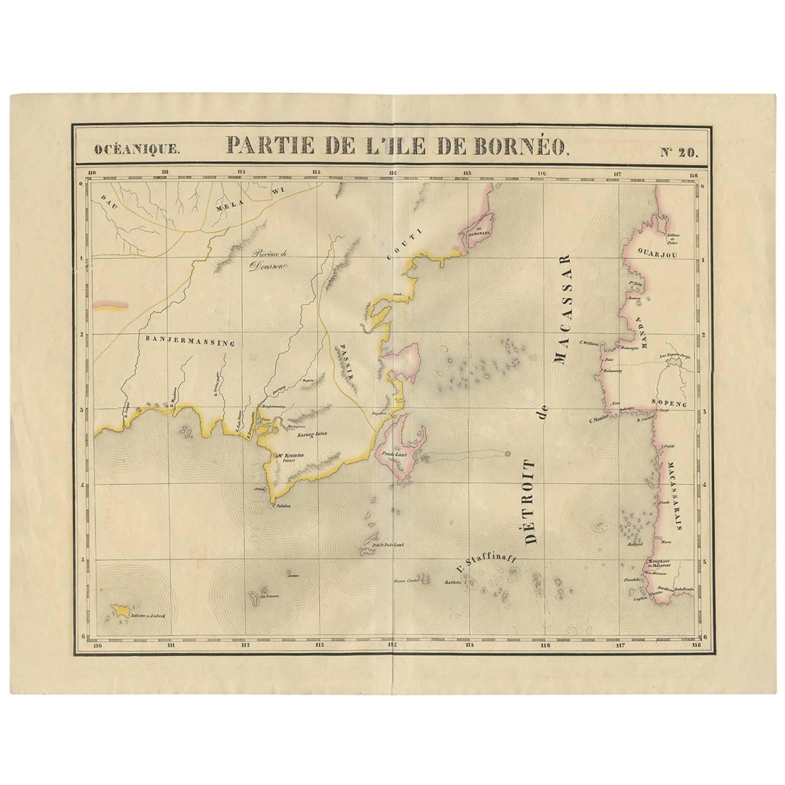
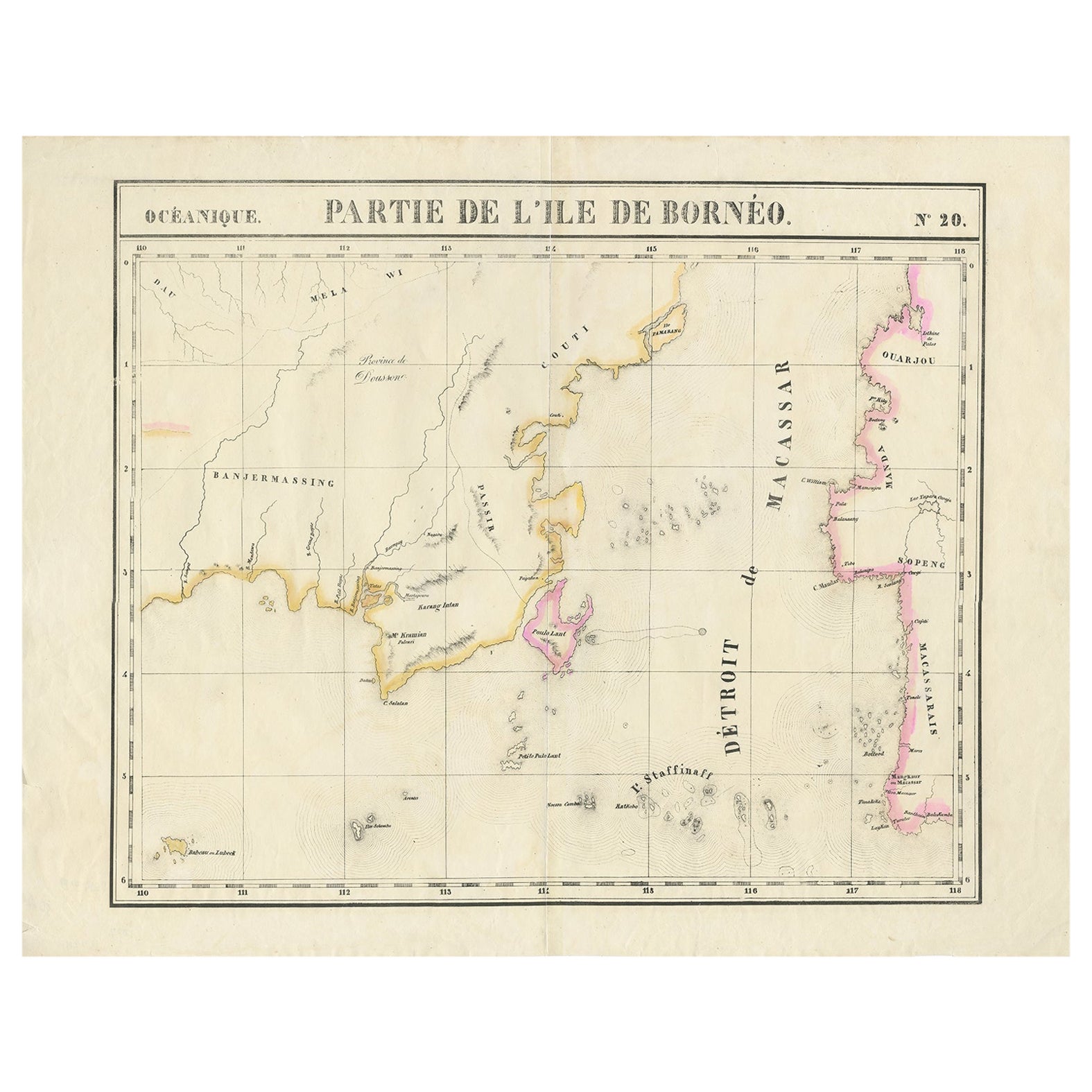
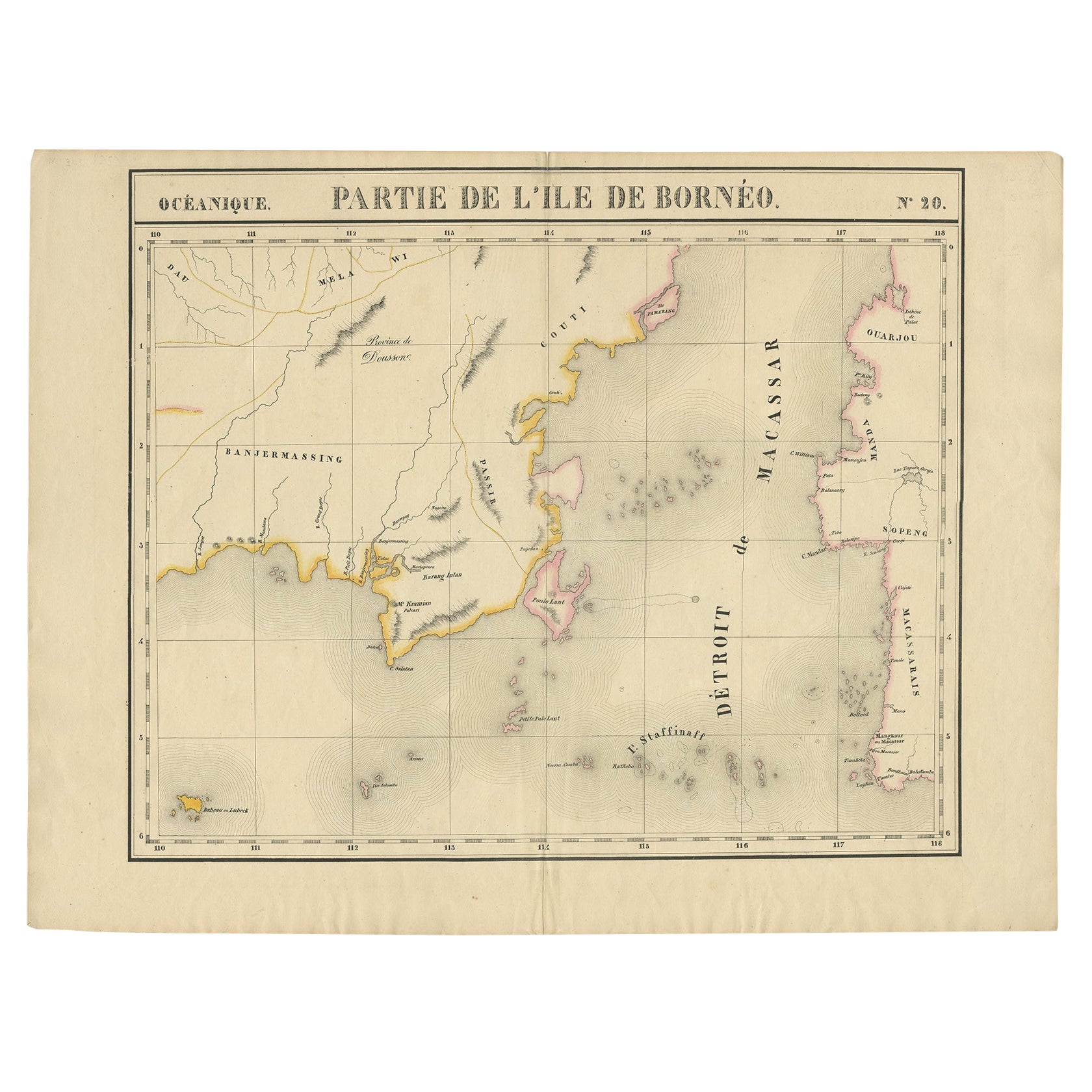
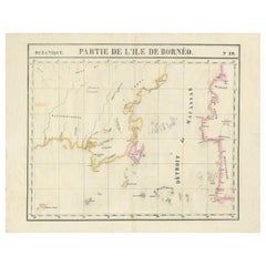
Detailed Antique Map of a Portion of Borneo and Sulawesi in Indonesia, c.1825
Located in Langweer, NL
Antique map titled 'Partie de l'Ile de Bornéo'. Map of a portion of Borneo, primarily the Southern part of the Island, the Strait of Macassar and the Staffinaff Islands. Originates f...
Category
Antique 19th Century Maps
Materials
Paper
$518 Sale Price
20% Off
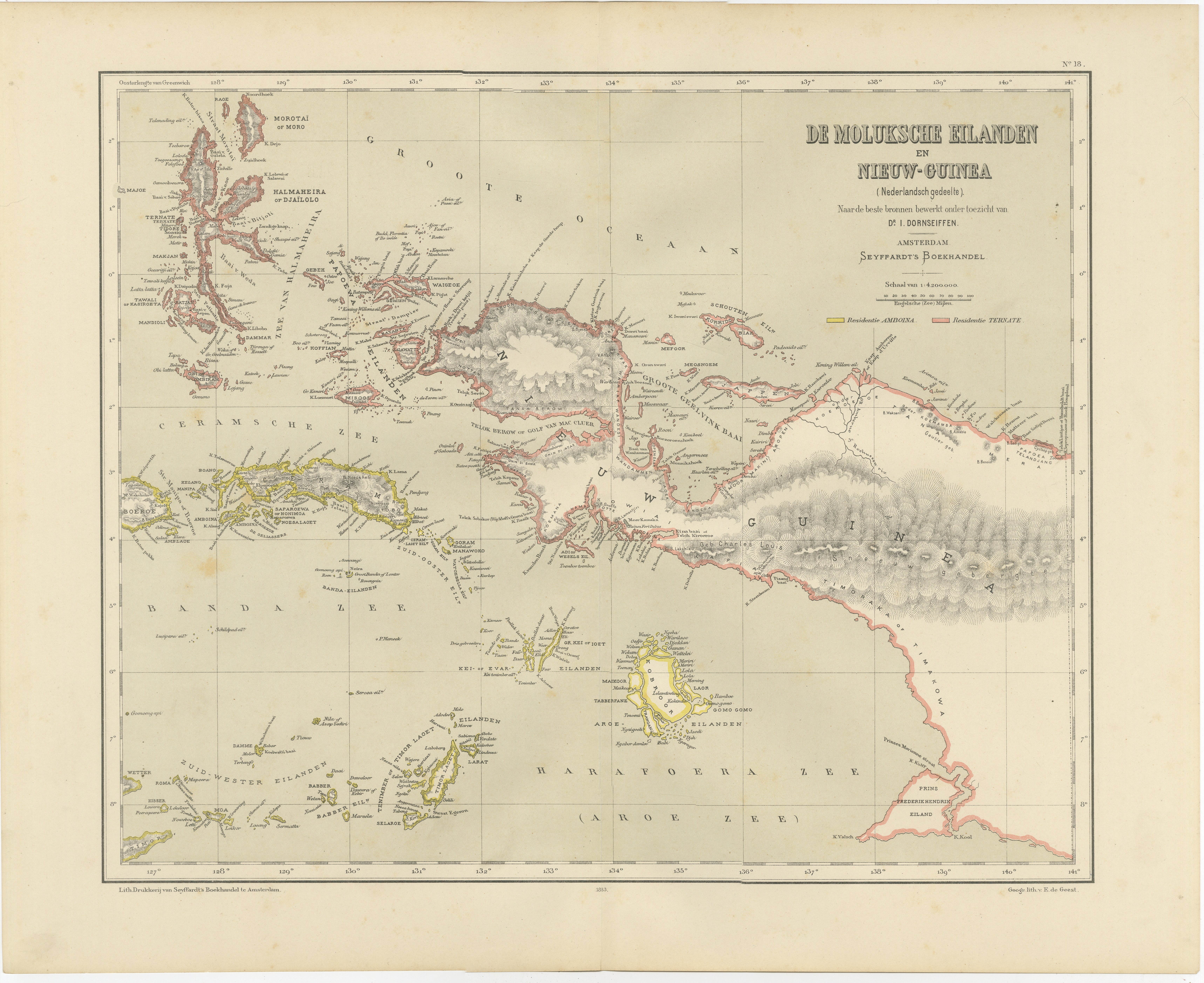
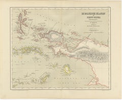
Antique Colonial Dutch Map of the Moluccas
New Guinea by Dornseiffen, 1884
Located in Langweer, NL
Antique Dutch Map of the Moluccas & New Guinea by Dornseiffen 1884 Indonesia
This decorative antique map depicts the Moluccan Islands (Spice Islands) and the western portion of New ...
Category
Antique 1880s Dutch Maps
Materials
Paper
Antique Map of Part of Borneo
Kalimantan
Indonesia, by Vandermaelen, C.1825
Located in Langweer, NL
Antique map titled 'Partie de l'Ile de Bornéo'. Map of a portion of Borneo, primarily the Southern part of the Island, the Strait of Macassar and the Staffinaff Islands. Originates f...
Category
Antique 19th Century Maps
Materials
Paper
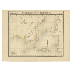
$595 Sale Price
20% Off
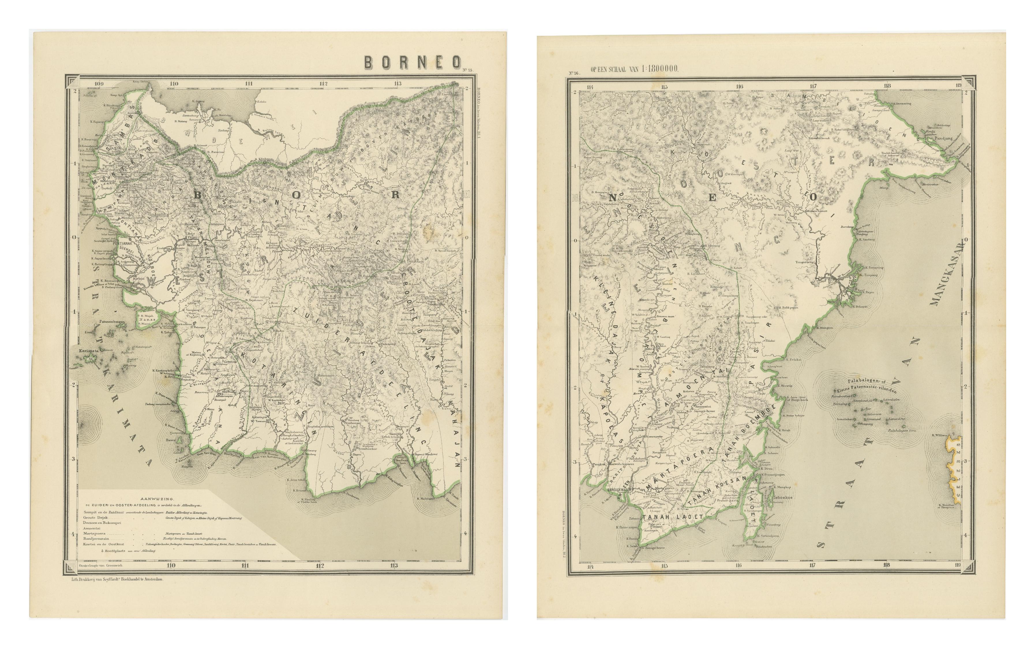
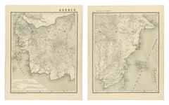
Antique Map Set of Western
Southern Borneo, Dutch East Indies Era, 1884
Located in Langweer, NL
Antique Map Set of Western and Southern Borneo, Dutch East Indies Colonial Era
This impressive two-sheet antique map set depicts the western and southern regions of the island of Bo...
Category
Antique 1880s Dutch Maps
Materials
Paper
You May Also Like
Large Original Antique Map of Java and Borneo, Fullarton, C.1870
Located in St Annes, Lancashire
Great map of Java and Borneo
Wonderful figurative borders
From the celebrated Royal Illustrated Atlas
Lithograph. Original color.
Published by Fullarton, Edinburgh. C.1870
Unfr...
Category
Antique 1870s Scottish Maps
Materials
Paper

Antique 1803 Italian Map of Asia Including China Indoneseia India
Located in Amsterdam, Noord Holland
Antique 1803 Italian Map of Asia Including China Indoneseia India
Very nice map of Asia. 1803.
Additional information:
Type: Map
Country of Manufacturing: Europe
Period: 19th centu...
Category
Antique 19th Century European Maps
Materials
Paper

$438 Sale Price
39% Off
Large Original Vintage Map of S.E Asia, with a Vignette of Singapore
Located in St Annes, Lancashire
Great map of South East Asia
Original color. Good condition
Published by Alexander Gross
Unframed.
Category
Vintage 1920s English Maps
Materials
Paper

Original Antique Map of South East Asia by Thomas Clerk, 1817
Located in St Annes, Lancashire
Great map of South East Asia
Copper-plate engraving
Drawn and engraved by Thomas Clerk, Edinburgh.
Published by Mackenzie And Dent, 1817
Unframed.
Category
Antique 1810s English Maps
Materials
Paper

Map of the East Indies: An Original 18th Century Hand-colored Map by E. Bowen
Located in Alamo, CA
This is an original 18th century hand-colored map entitled "An Accurate Map of the East Indies Exhibiting the Course of the European Trade both on the Continent and Islands" by Emanu...
Category
Mid-18th Century Old Masters Landscape Prints
Materials
Engraving

$1,020 Sale Price
20% Off
Africa. North-West Part. Century Atlas antique vintage map
Located in Melbourne, Victoria
'The Century Atlas. Africa. Southern Part'
Original antique map, 1903.
Central fold as issued. Map name and number printed on the reverse corners.
Sheet 40cm by 29.5cm.
Category
Early 20th Century Victorian More Prints
Materials
Lithograph
