Items Similar to Rare Antique Map of Leeuwarden by P. Bast, 1603, Wall Art, Netherlands

Want more images or videos?
Request additional images or videos from the seller
1 of 10
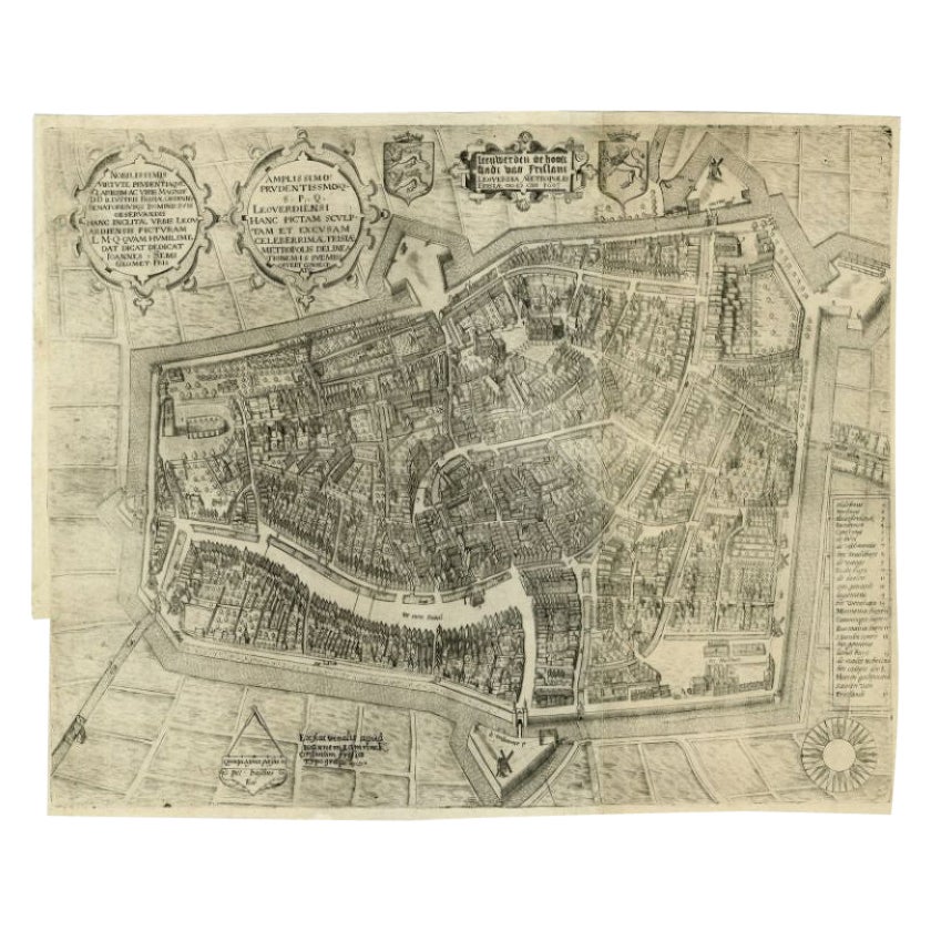
Rare Antique Map of Leeuwarden by P. Bast, 1603, Wall Art, Netherlands
$4,053.37
$5,404.5025% Off
£3,002.50
£4,003.3325% Off
€3,375
€4,50025% Off
CA$5,546.03
CA$7,394.7025% Off
A$6,034.50
A$8,04625% Off
CHF 3,195.19
CHF 4,260.2625% Off
MX$72,599.13
MX$96,798.8325% Off
NOK 40,571.82
NOK 54,095.7525% Off
SEK 37,120.37
SEK 49,493.8325% Off
DKK 25,720.26
DKK 34,293.6825% Off
About the Item
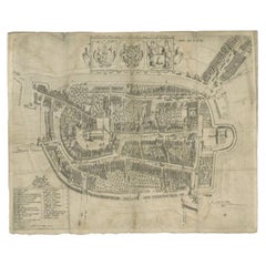
Rare Antique Map of Leeuwarden, Friesland, The Netherlands, by P. Bast, 1603
This exceptionally rare city plan depicts Leeuwarden, the capital of Friesland in the northern Netherlands, as it appeared in the early 17th century. Engraved by Pieter Bast after a detailed survey by the renowned engineer and surveyor Johan Sems, and published in 1603 by Jan Lamrinck (Ioannem Lamrinck), the map ranks among the earliest and most important printed plans of Leeuwarden.
The plan presents the fortified city in precise detail, showing its polygonal bastioned defenses, moats, canals, and street layout with remarkable clarity. Individual houses, churches, public buildings, and gardens are carefully delineated, reflecting the growing Dutch interest in urban planning, military engineering, and accurate land surveying at the dawn of the Golden Age. The surrounding fields and waterways emphasize Leeuwarden’s strategic position within the Frisian landscape.
Several ornamental cartouches enrich the composition, including dedicatory inscriptions and coats of arms that underline the civic pride and political status of the city. A clearly engraved legend identifies key locations within the urban fabric, while the compass rose at the lower right provides orientation and adds a decorative balance to the overall design. The combination of functional clarity and refined ornamentation is characteristic of Pieter Bast’s work and of early Dutch city cartography more broadly.
As one of the earliest printed plans based on an actual survey, this map is not only a topographical document but also a historical record of Leeuwarden’s urban form at a pivotal moment in its development. Its rarity, early date, and strong visual presence make it highly desirable for collectors of Dutch cartography, Frisian history, and early modern city plans.
Technique: Copper engraving
Maker: Pieter Bast after Johan Sems, published by Jan Lamrinck, Netherlands, 1603
- Creator:P. Bast (Artist)
- Dimensions:Height: 16.15 in (41 cm)Width: 19.89 in (50.5 cm)Depth: 0.02 in (0.5 mm)
- Materials and Techniques:Paper,Engraved
- Period:Early 17th Century
- Date of Manufacture:1603
- Condition:Wear consistent with age and use. Overall light to moderate age toning and uniform wear consistent with early 17th-century paper. Minor foxing and light surface soiling. Small marginal stains and faint creases. Plate impression clear and strong; margins ample with no major losses.
- Seller Location:Langweer, NL
- Reference Number:Seller: BG-021171stDibs: LU305438832703
About the Seller
5.0
Recognized Seller
These prestigious sellers are industry leaders and represent the highest echelon for item quality and design.
Platinum Seller
Premium sellers with a 4.7+ rating and 24-hour response times
Established in 2009
1stDibs seller since 2017
2,816 sales on 1stDibs
Typical response time: 1 hour
- ShippingRetrieving quote...Shipping from: Langweer, Netherlands
- Return Policy
More From This Seller
View AllAntique Map of the City of Leeuwarden by Bast, 1603
Located in Langweer, NL
Antique map titled 'Leeuwerden de hooft stadt van Frislant. Leoverdia Metropolis Frisiae (…) 1603.' Very rare plan of Leeuwarden, Friesland, The Netherlands. With several carouches a...
Category
Antique 17th Century Maps
Materials
Paper

$2,618 Sale Price
20% Off
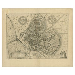
Antique Map of Leeuwarden, Capital of Friesland, the Netherlands, by Blaeu, 1649
Located in Langweer, NL
Antique map titled 'Leoverdia.'
Bird's-eye view plan of Leeuwarden, Friesland, the Netherlands. With key to locations and coats of arms. Text in Dutch on verso.
This plan origina...
Category
Antique 17th Century Maps
Materials
Paper

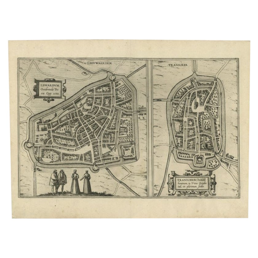
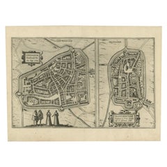
Antique Map of the City of Leeuwarden and Franeker by Braun
Hogenberg, 1580
Located in Langweer, NL
Antique map titled 'Lewardum Occidentlis Frisiae Opp: 1580, Franicher Nobiliu hominum, in Frisia Occidentali, ut plurimum saedes'. This sheet contains two very detailed bird’s-eye pl...
Category
Antique 16th Century Maps
Materials
Paper
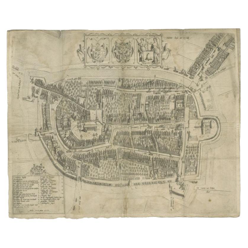
Antique Map of the City of Franeker by Bast, 1598
Located in Langweer, NL
Antique map titled 'Franeker'. Very rare and early map of the city of Franeker, Friesland. With decorative cartouche and Dutch legend. Artists and Engravers: Pieter Bast (1550-1605) ...
Category
Antique 16th Century Maps
Materials
Paper
$1,076 Sale Price
20% Off
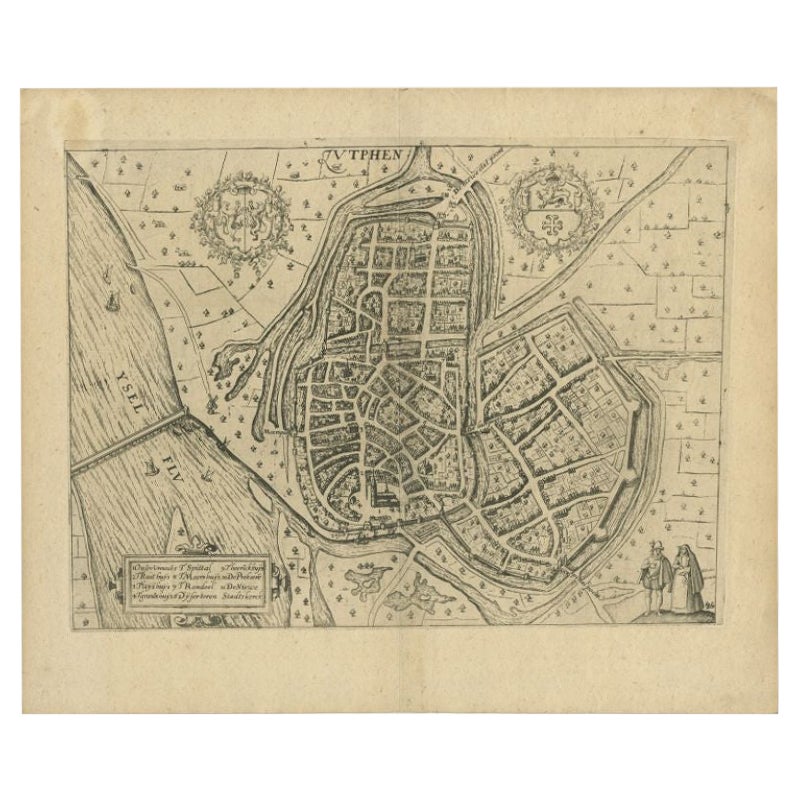
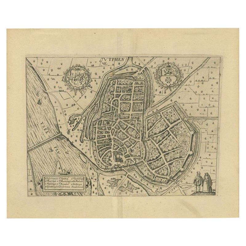
Antique Map of the City of Zutphen by Guicciardini, 1613
Located in Langweer, NL
Antique map Zutphen titled 'Zutphen'. This map depicts the city of Zutphen, Gelderland, The Netherlands. Originates from 'Discrittione di tutti i Paesi Bassi'.
Artists and Engrav...
Category
Antique 17th Century Maps
Materials
Paper
Antique Map of the City of Zutphen by Guicciardini, 1612
Located in Langweer, NL
Antique map Zutphen titled 'Zutphen'. This map depicts the city of Zutphen, Gelderland, The Netherlands. Originates from 'Beschryvinghe van alle de Neder-landen anderssins ghenoemt N...
Category
Antique 17th Century Maps
Materials
Paper

You May Also Like
Utrecht, Antique Map from "Civitates Orbis Terrarum"
By Franz Hogenberg
Located in Roma, IT
Braun G., Hogenberg F., Traiectum or Utrecht, from the collection Civitates Orbis Terrarum, Cologne, T. Graminaeus, 1572-1617.
Very fine B/W aquatint showing a view of Utrecht, with...
Category
16th Century Landscape Prints
Materials
Etching

Map of Groningen - Etching by George Braun - Late 16th Century
Located in Roma, IT
This map of Groninga is an original etching realized by George Braun and Franz Hogenberg, and part of the series "Civitates Orbis Terrarum".
The state of preservation of the artwork...
Category
16th Century Figurative Prints
Materials
Etching

Map of Antwerp - Etching by G.Braun and F. Hogenberg -Late 16th century
By Franz Hogenberg
Located in Roma, IT
This Map of Anverpia is an original etching hand colored realized by George Braun and Franz Hogenberg as part of the famous Atlas "Civitates Orbis Ter...
Category
16th Century Old Masters Figurative Prints
Materials
Etching

Map of the Netherlands - Etching by G. Braun and F. Hogenberg -Late 16th Century
By Franz Hogenberg
Located in Roma, IT
Map of the Netherlands is an original etching realized by George Braun and Franz Hogenberg, as part of the "Civitates Orbis Terrarum".
The “Civitates Orbis Terrarum” (Atlas of Citi...
Category
16th Century Figurative Prints
Materials
Etching

Map of Kampen, Netherlands - by G. Braun and F. Hogenberg - Late 16th Century
By Franz Hogenberg
Located in Roma, IT
This map of Kampen (the ancient Campensis) is an original etching realized by George Braun and Franz Hogenberg as part of the famous Series "Civitates Orbis Terrarum".
The “Civita...
Category
16th Century Figurative Prints
Materials
Etching

Map of Cambridge, engraving Pieter van der Aa after David Loggan
By Pieter Van Der Aa
Located in London, GB
Pieter van der Aa (1659 - 1733), after David Loggan (1634 - 1692)
Map of Cambridge
Engraving
12 x 16 cm
An eighteenth-century view of Cambridge, engraved by Pieter van der Aa after ...
Category
Early 18th Century Realist Prints and Multiples
Materials
Engraving

More Ways To Browse
Antique Russian Rugs
For Kids
Sterling Silver Flatware Set Service For 12
Tufted Bar
Pair Of French Antique Armchairs
1970s Brass Glass Coffee Table
Charles Rennie Mackintosh For Cassina
Glass Salt
Italian Modern Silver Vases
Vintage Resin Tables
Antique English Country Furniture
Blue Kilim Vintage
Contemporary Side Tables And Stools
Decorative Wall Plate
Mid Century Modern Corner Chair
Dining Tables With Brass Inlay
Oak Mid Century Armchair
Solid Wood Side Table Stool