Want more images or videos?
Request additional images or videos from the seller
1 of 5
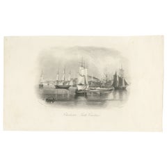
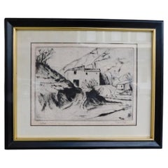
Rare Charleston, South Carolina Engraved Map "Town
Harbor, " Circa 1700
$3,800List Price
About the Item
About the Seller
4.7
Vetted Professional Seller
Every seller passes strict standards for authenticity and reliability
Established in 1970
1stDibs seller since 2010
443 sales on 1stDibs
Typical response time: 3 hours
Authenticity Guarantee
In the unlikely event there’s an issue with an item’s authenticity, contact us within 1 year for a full refund. DetailsMoney-Back Guarantee
If your item is not as described, is damaged in transit, or does not arrive, contact us within 7 days for a full refund. Details24-Hour Cancellation
You have a 24-hour grace period in which to reconsider your purchase, with no questions asked.Vetted Professional Sellers
Our world-class sellers must adhere to strict standards for service and quality, maintaining the integrity of our listings.Price-Match Guarantee
If you find that a seller listed the same item for a lower price elsewhere, we’ll match it.Trusted Global Delivery
Our best-in-class carrier network provides specialized shipping options worldwide, including custom delivery.You May Also Like
Charleston Harbor, South Carolina – American Port View, Sailing Ships, c.1850
Located in Langweer, NL
Charleston Harbor, South Carolina – American Port View, Sailing Ships, c.1850
Description:
This refined mid-19th-century engraving presents a tranquil harbor view of Charleston, Sou...
Category
Antique 1850s American Prints
Materials
Paper
$264
H 5.91 in W 9.85 in D 0.01 in
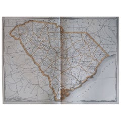
Large Original Antique Map of South Carolina, USA, 1894
By Rand McNally
Co.
Located in St Annes, Lancashire
Fabulous map of South Carolina
Original color
By Rand, McNally & Co.
Published, 1894
Unframed
Free shipping.
Category
Antique 1890s American Maps
Materials
Paper
Framed 17th Century Map of Cumberland, England by John Speed, 1610
By John Speed
Located in Middleburg, VA
A fascinating and richly detailed antique map of Cumberland County in northwest England, drawn and published by the celebrated English cartographer John Spe...
Category
Antique Early 17th Century English British Colonial Maps
Materials
Copper, Gold Leaf

Extremely Large Hand-Drawn Manuscript Map of Surinam, 1830, History of Slavery
Located in Amsterdam, NL
A unique large hand-drawn map of Surinam by Albrecht Helmut Hiemcke (German, 1760-1839)
?
'Colonie Surinaame', 1830
A large hand-drawn and coloured map of the colony of Suri...
Category
Antique Mid-19th Century Surinamer Maps
Materials
Paper

$45,647
Free Shipping
H 34.85 in W 97.05 in D 0.08 in
Antique Framed Pen and Ink on Fabric Map of Cornwall from Early 19th Century
Located in Los Angeles, CA
This English fabric map of Cornwall, rendered in pen-and-ink, showcases exquisite hand-drawn details and charming faded sepia tones. Encased in a classic frame, this piece elegantly ...
Category
Antique Early 19th Century English Drawings
Materials
Walnut, Fabric

$2,475
H 30.5 in W 44.5 in D 1 in
Original Antique Map of the American State of South Carolina, 1903
Located in St Annes, Lancashire
Antique map of South Carolina
Published By A & C Black. 1903
Original colour
Good condition
Unframed.
Free shipping
Category
Antique Early 1900s English Maps
Materials
Paper

$49
Free Shipping
H 11.5 in W 16.25 in D 0.07 in
Antique Map of Portugal by P. Schenk, circa 1700
Located in Langweer, NL
Antique map titled 'Portugalliae et Algarbia'. Striking example of Schenk's rare map of Portugal, with the coats of arms of Portugal, Algarbia and a Spanish sailing vessell in the ca...
Category
Antique Early 18th Century Maps
Materials
Paper

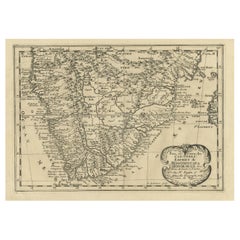
Original Copperplate Engraved Detailed Map of South Africa, ca.1680
Located in Langweer, NL
Antique map titled 'Pays et Coste des Caffres Empires de Monomotapa (..)'.
Detailed map of South Africa. Engraved by Antoine d'Winter for a Dutch edition of Sanson's pocket atlas...
Category
Antique 1680s Maps
Materials
Paper
$345 Sale Price
20% Off
H 9.65 in W 14.57 in D 0 in
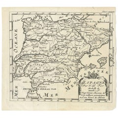
Antique 1700 Map of Spain by Nicolas de Fer, Early 18th Century
Located in Langweer, NL
Antique map of Spain and Portugal with a title cartouche. Nicolas de Fer was the youngest son of the Paris printer and publisher Antoine de Fer. At the ...
Category
Antique Early 18th Century French Maps
Materials
Paper
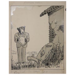
Fred Lundy CA Great Depression Cartoon Illustration, circa 1938
Located in San Francisco, CA
Rare original cartoon illustration by listed American cartoonist Fred Lundy.
Fred Ralph Lundy (1902-1989) studied art at the University of Oregon before moving to California in 1924. Following further study at the CCAC, he was an artist with the Oakland Tribune from 1935-1935 and an editorial cartoonist for the San Francisco Examiner from 1935 until retirement in 1976. His cartoons appeared in Saturday Evening Post, Colliers, Esquire, New Yorker, and other national magazines. He died in Daly City...
Category
Early 20th Century American Drawings
Materials
Paper
More From This Seller
View AllFrench Framed Copper Engraved Hand Colored Map of Carolina
Georgia, Circa 1757
Located in Charleston, SC
French copper engraved hand colored map of Carolina & Georgia matted under glass with a painted frame, mid-18th century
Category
Antique 1750s French Louis XV Maps
Materials
Glass, Wood, Paint, Paper
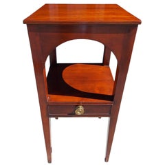
Charleston Cherry Arched Frieze Basin Stand, South Carolina, Circa 1800
Located in Charleston, SC
American Cherry basin stand with carved arched friezes, single drawer with the original brass knob, and terminating on tapered squared inlaid double cuffed...
Category
Antique Early 1800s American American Colonial Side Tables
Materials
Brass
English Engraved Hand Colored Map of the North Eastern United States, circa 1817
Located in Charleston, SC
English copper engraved hand colored map of the North Eastern United States matted under glass in a gilt frame, Early 19th Century. Drawn and Engraved for Thomson's New General Atlas...
Category
Antique 1810s English George III Maps
Materials
Glass, Giltwood, Paint, Paper

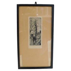
Elizabeth O
Neil Verner Framed Etching St. Phillips Steeple, Charleston, SC 1925
Located in Charleston, SC
Elizabeth O'Neil Verner framed dry point etching of St. Phillips Church Steeple, Charleston, SC. Early 20th Century
Category
Vintage 1920s American Art Nouveau Drawings
Materials
Glass, Wood, Paper
American Dry Point Engraved Etching Italian House on Hill Side, A. Hutty C 1920
By Alfred Hutty
Located in Charleston, SC
American dry point engraved landscape etching Italian House on Hill Side, Alfred H. Hutty, Early 20th century
Category
Vintage 1920s American Modern Drawings
Materials
Paper
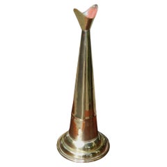
American Cast Brass Engraved Yachtsman
s Speaking Trumpet, Circa 1830
Located in Charleston, SC
American hand held cast brass engraved Yachtsman's speaking trumpet with bell shaped soldered mouthpiece, coned-shaped column with original interior red paint, and terminating on a r...
Category
Antique 1830s American American Empire Nautical Objects
Materials
Brass
Still Thinking About These?
All Recently ViewedMore Ways To Browse
Charleston Used Office Furniture
Aden Yemen
Dakota Johnson
French School Map
L Tardieu
Laos Antique Map
Map New Holland
Mauritius Antique Map
Nantucket Poster
Nicolas Baier
Ruben Benjamin
Washington Dc Map
Wood Carved Golfer
1681 Moses Pitt
Antique Map Bermuda
Antique Map Of Brooklyn
Antique Map Of Republic Of Texas
Extra Large Map