Want more images or videos?
Request additional images or videos from the seller
1 of 6
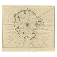
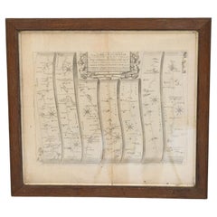
Rare Map of Cape of Good Hope from the Doornbosch River to Algoa Bay, 1726
Price:$750
$1,502.38List Price
About the Item
- Dimensions:Height: 18.9 in (48 cm)Width: 22.84 in (58 cm)Depth: 0 in (0.02 mm)
- Materials and Techniques:
- Period:1720-1729
- Date of Manufacture:1726
- Condition:Additions or alterations made to the original: Condition: Good, general age-related toning. Few repairs on folding lines. Please study image carefully. Repaired: Few repairs on folding lines. Wear consistent with age and use. Condition: Good, general age-related toning. Few repairs on folding lines. Please study image carefully.
- Seller Location:Langweer, NL
- Reference Number:Seller: BGRN-249 1stDibs: LU3054326762562
About the Seller
5.0
Recognized Seller
These prestigious sellers are industry leaders and represent the highest echelon for item quality and design.
Platinum Seller
Premium sellers with a 4.7+ rating and 24-hour response times
Established in 2009
1stDibs seller since 2017
2,813 sales on 1stDibs
Typical response time: 1 hour
Authenticity Guarantee
In the unlikely event there’s an issue with an item’s authenticity, contact us within 1 year for a full refund. DetailsMoney-Back Guarantee
If your item is not as described, is damaged in transit, or does not arrive, contact us within 7 days for a full refund. Details24-Hour Cancellation
You have a 24-hour grace period in which to reconsider your purchase, with no questions asked.Vetted Professional Sellers
Our world-class sellers must adhere to strict standards for service and quality, maintaining the integrity of our listings.Price-Match Guarantee
If you find that a seller listed the same item for a lower price elsewhere, we’ll match it.Trusted Global Delivery
Our best-in-class carrier network provides specialized shipping options worldwide, including custom delivery.You May Also Like
Voyage to the Cape of Good Hope, First Edition, c1785
Located in valatie, NY
Voyage to the Cape of Good Hope, towards the Antarctic polar circle, and round the world, but chiefly into the country of the Caffres, from the year ...
Category
Antique 18th Century Irish Books
Materials
Leather, Paper
Engraved
Cape of Good Hope
Colonial Commemorative Glass, 18th Century
Located in Amsterdam, NL
A commemorating glass with an engraving of a farmer ploughing, an East Indiaman and a text reading:
Het Lan’s Wel Varen An De Caap (the country’s prosperity at the Cape of Good Hope...
Category
Antique 18th Century South African Glass
Materials
Glass
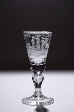
$11,898
Free Shipping
H 3.35 in Dm 7.88 in
Antique 1798 James Colnett A Voyage to the South Atlantic
Round Cape Hope Book
Located in Hamilton, Ontario
This antique book titled "A Voyage to the South Atlantic and Round Cape Horn into the Pacific Ocean", and authored by W. Bennett, on the work of James Colnet...
Category
Antique Late 18th Century English Georgian Books
Materials
Leather, Paper
$8,550
H 1 in W 10 in D 1 in
1939 "A Good-Natured Map of the United States" by Greyhound
Located in Colorado Springs, CO
Presented is an original 1939 map, titled “A Good-Natured Map of the United States Setting Forth the Services of the Greyhound Lines and a Few Principal Connecting Bus Lines.” This brightly colored pictographic map was one of several similar United States maps...
Category
Vintage 1930s American Art Deco Maps
Materials
Paper

Map of the York to Weft-Chester Road
Located in London, England
A road map or strip map by John Ogilby, showing the route from Warrington to Derby, taken from the 1698 edition of Ogilby’s ‘Britannia’ map. Later solid oak frame.
U.K circa 1700.
H ...
Category
Antique Early 1700s Maps
Materials
Paper
The Overland Guide From the Missouri River to the Pacific Ocean, Revised, 1883
Located in Colorado Springs, CO
Gleed, Charles S, ed. Rand, McNally & Co.'s Overland Guide From the Missouri River to the Pacific Ocean Via Kansas, Colorado, New Mexico, Arizona and California. Chicago: Rand, McNally & Co., 1883. Revised Edition. Rebound in ¼ red leather and cloth boards, with original cloth gilt-stamped pictorial front board saved, new marbled endpapers, and a custom archival slipcase to match. Illustrated throughout with engravings.
This is a “Revised Edition” of the Rand, McNally & Co.'s Overland Guide From the Missouri River to the Pacific Ocean, via Kansas, Colorado, New Mexico, Arizona and California. The book was edited by Charles S. Gleed and published by Rand, McNally & Co., in Chicago in 1883. It has been artfully rebound in ¼ red leather and cloth boards, with the original gilt-stamped pictorial front cloth board saved, new marbled endpapers, and a matching archival cloth slipcase.
As explained in the beginning of the guidebook, the purpose of the book is “to give the reader a satisfactory general idea of the States and Territories of Kansas, Colorado, New Mexico, Arizona, and California, through which the traveler passes in going from the Missouri river to the Pacific ocean, or vice versa, entering or leaving California at its southern extremity.” Following the southern route of railways, editor Charles Gleed lays out in extensive detail information on each state, including population numbers, key industries, important towns and railway stations, farming and agriculture, mining opportunities, and weather patterns.
Throughout the guidebook are countless engravings, both full page and in-text, from well known engravers of the time. Meant to further entice readers to take this overland journey, the illustrations offer views of key tourist spots, townviews, and scenic destinations, throughout the featured states of Kansas, Colorado, New Mexico, Arizona, and California. The guidebook is also supplemented by pages of printed advertisements in the beginning of the book, showcasing local businesses, services, and wares.
Charles Sumner...
Category
Antique 1880s American Late Victorian Books
Materials
Leather, Fabric, Paper
$1,500
H 8.38 in W 6 in D 1.63 in
1856 U.S. Coast Survey Map of Chesapeake Bay and Delaware Bay
Located in Colorado Springs, CO
Presented is U.S. Coast Survey nautical chart or maritime map of Chesapeake Bay and Delaware Bay from 1856. The map depicts the region from Susquehanna, Maryland to the northern Outer Banks in North Carolina. It also shows from Richmond and Petersburg, Virginia to the Atlantic Ocean. The map is highly detailed with many cities and towns labeled throughout. Rivers, inlets, and bays are also labeled. Various charts illustrating more specific parts of the region are marked on the map using dotted lines. The lines form boxes, and the corresponding chart number and publication date are given. Extensive triangulation surveys were conducted the length of Chesapeake Bay and are illustrated here. Hampton Roads, Virginia is labeled, along with the James, York, and Rappahannock Rivers, which were all extensively surveyed.
The chart was published under the supervision of A. D. Bache, one of the most influential and prolific figures in the early history of the U.S. Coast Survey, for the 1856 Report of the Superintendent of the U.S. Coast Survey. Alexander Dallas Bache (1806-1867) was an American physicist, scientist, and surveyor. Bache served as the Superintendent of the U.S. Coast Survey from 1843 to 1865. Born in Philadelphia, Bache toured Europe and composed an important treatise on European Education. He also served as president of Philadelphia's Central High School and was a professor of natural history and chemistry at the University of Pennsylvania. Upon the death of Ferdinand Rudolph Hassler, Bache was appointed Superintendent of the United States Coast Survey.
The Office of the Coast Survey, founded in 1807 by President Thomas Jefferson and Secretary of Commerce Albert Gallatin...
Category
Antique 1850s American Maps
Materials
Paper

Antique Map of Virginia
the Chesapeake Bay by Jacques-Nicolas Bellin, c. 1750
By Jacques-Nicolas Bellin
Located in Philadelphia, PA
A fine antique 18th century French map of North America.
By Jacques-Nicolas Bellin.
On laid paper with polychrome highlights.
Depicting Virginia, the Chesapeake Bay, and the nearb...
Category
Antique 18th Century French Baroque Maps
Materials
Paper

$895
H 15.13 in W 18.63 in D 1.13 in
Exhibition Catalogue of Chinese Glass from the Hope Danby Collection
Located in valatie, NY
An Exhibition Catalogue of Chinese Glass from The Hope Danby Collection. London: S. Marchant and Sons, 1999. First edition hardcover with dust jacket. 44 pp. A beautiful catalogue fo...
Category
20th Century English Books
Materials
Paper

Scarce U.S. Coast Survey Map Depicting Entrance to San Francisco Bay Dated 1856
Located in San Francisco, CA
A fine example of the 1856 U.S. Coast lithographic survey nautical chart of the entrance to San Francisco bay and the city. Published in 1856 by the Office of the Coast Survey the of...
Category
Antique Mid-19th Century American Maps
Materials
Paper

$780 Sale Price
47% Off
H 28 in W 46 in D 1.5 in
More From This Seller
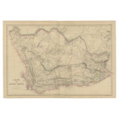
View AllAntique Map of the Cape of Good Hope by W. G. Blackie, 1859
Located in Langweer, NL
Antique map titled 'Cape of Good Hope'. Original antique map of the Cape of Good Hope. This map originates from ‘The Imperial Atlas of Modern Geography’. Published by W. G. Blackie, ...
Category
Antique Mid-19th Century English Maps
Materials
Paper
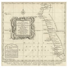
Dutch Antique Map of the West Coast of Africa, to the Cape of Good Hope, 1747
Located in Langweer, NL
Antique map of the Coast of Africa titled 'Kaart van de West Kust van Afrika (..)'.
Map of the west coast of Africa, from 11 degrees south latitude to the Cape of Good Hope. This...
Category
Antique 1740s Maps
Materials
Paper
$374 Sale Price
20% Off
Free Shipping
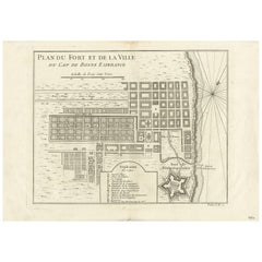
Antique Map of the Cape of Good Hope by J.N. Bellin, 1748
Located in Langweer, NL
Early plan of the Cape of Good Hope, includng a town plan and illustrations of the fortificatons. This map originates from Tome V of Abbe Prevost's Histoire generale du voyages.
Category
Antique Mid-18th Century Maps
Materials
Paper
Antique Map of the Coast of Guinea from, Cape Apollonia to the Volta River
Located in Langweer, NL
Antique map titled 'Suite de la Coste de Guinée (..) - Vervolg van de Kust van Guinée (..)'. Decorative map of the coast of Guinea from, Cape Apollonia to the Volta River. Engraved b...
Category
Antique Mid-18th Century Maps
Materials
Paper
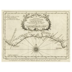
$346 Sale Price
20% Off
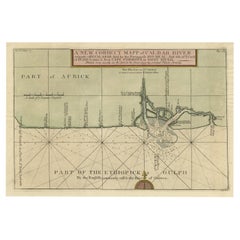
Authentic Map of the Coast from Cape Formosa to the Dony River, Africa, 1732
Located in Langweer, NL
Antique map titled 'The New Correct Mapp of Calbar River vulgarly call'd Calabar (..)'.
An interesting map of the coast from Cape Formosa to the Dony River stated on the map to be ...
Category
Antique 1730s Maps
Materials
Paper
Antique Engraved Map of Manila, the Earliest Obtainable Map of Manila Bay, 1726
Located in Langweer, NL
Antique map titled 'Manilhas Bay'. This map is considered the earliest obtainable map of Manila Bay. Depicts Manila Bay, locating the city of Manila, Castle (Cabitta), Cloister of Sa...
Category
Antique 18th Century Maps
Materials
Paper