Want more images or videos?
Request additional images or videos from the seller
1 of 9
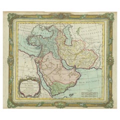
Rare Near
Middle East Map by G.W. Bacon
Co. LTD, London, circa 1880
Price:$465
About the Item
- Dimensions:Height: 30.75 in (78.11 cm)Width: 40.75 in (103.51 cm)Depth: 0.2 in (5.08 mm)
- Materials and Techniques:
- Place of Origin:
- Period:
- Date of Manufacture:circa 1880
- Condition:Wear consistent with age and use. Folded dimensions 8" x 10".
- Seller Location:San Francisco, CA
- Reference Number:1stDibs: LU5199219585232
About the Seller
5.0
Platinum Seller
Premium sellers with a 4.7+ rating and 24-hour response times
Established in 1985
1stDibs seller since 2020
409 sales on 1stDibs
Typical response time: 3 hours
Authenticity Guarantee
In the unlikely event there’s an issue with an item’s authenticity, contact us within 1 year for a full refund. DetailsMoney-Back Guarantee
If your item is not as described, is damaged in transit, or does not arrive, contact us within 7 days for a full refund. Details24-Hour Cancellation
You have a 24-hour grace period in which to reconsider your purchase, with no questions asked.Vetted Professional Sellers
Our world-class sellers must adhere to strict standards for service and quality, maintaining the integrity of our listings.Price-Match Guarantee
If you find that a seller listed the same item for a lower price elsewhere, we’ll match it.Trusted Global Delivery
Our best-in-class carrier network provides specialized shipping options worldwide, including custom delivery.You May Also Like
Rare Antique Map of the Middle East, ca.1690
Located in Langweer, NL
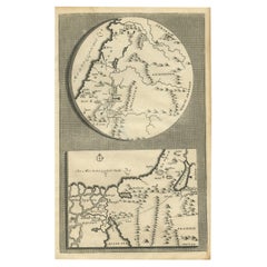
Description: Antique print, untitled.
Two decorative maps on one sheet of the middle east in biblical times. Source unknown, to be determined.
Artists and Engravers: Anonymous...
Category
Antique 1690s Prints
Materials
Paper
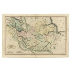
Antique Map of the Middle East by Smith, 1809
Located in Langweer, NL
Antique map titled 'Regiones inter Euphraten et Indum'. Old map of the Middle East showing the region between the Euphrates and Indus river. Ori...
Category
Antique 19th Century Maps
Materials
Paper
Antique Map of the Middle East by Perthes, 1848
Located in Langweer, NL
Antique map titled 'Terra inter Euphratem et Indum Antiqua'. Old map of the Middle East originating from 'Orbis Terrarum Antiquus in usum Schola...
Category
Antique 19th Century Maps
Materials
Paper

Antique Map of the Middle East by Mortier, 1700
Located in Langweer, NL
Antique map titled 'Carte de la Situation du Paradis Terrestre (..)'. Detailed map of the Holy Land and the Middle East, centered on the Garden of Eden and including a large Cyprus. ...
Category
Antique 18th Century Maps
Materials
Paper

Antique Bible Map of the Middle East by A. Schut, 1743
Located in Langweer, NL
Antique map titled 'De Gelegentheyt van 't Paradys en 't Landt Canaan'. Dutch Bible map covering the region between the Mediterranean and the Persian Gulf, ...
Category
Antique Mid-18th Century Maps
Materials
Paper

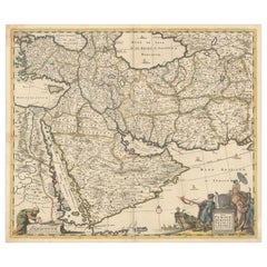
Circa 1691 Frederick de Wit Map: Middle East with Arabia, Persia
More
Located in Langweer, NL
Circa 1691 Frederick de Wit Map: Middle East with Arabia, Persia & More
This exquisite hand-colored map, circa 1691, by Frederick de Wit, illustrates the Middle East, spanning from Turkey and Egypt to Afghanistan, with a detailed representation of the Arabian Peninsula.
The map's detailing in Arabia is based on Nicolas Sanson's influential 1654 map, which was one of the most accurate and detailed depictions of the region up to the mid-seventeenth century.
The decorative title cartouche is richly adorned with images of exotic figures, animals, and a merchant ship, symbolizing the region's historical trade importance. Additionally, a mapmaker is shown working with traditional tools, adding a touch of authenticity to the cartographic art.
This is the fourth state of the map, published between 1691 and 1696. The map measures 21.8 inches in width by 18.5 inches in height, featuring a sharp impression, with minimal staining and a carefully repaired centerfold separation at the bottom.
Keywords:
- Middle East historical map
- Frederick de Wit map
- 17th century maps
- Arabian Peninsula map
- Persia (Iran) map
- Turkey and Egypt map...
Category
Antique 1690s Maps
Materials
Paper
$2,345 Sale Price
20% Off
H 18.5 in W 21.8 in D 0.002 in
Scarce Antique Map of the Middle East, Surrounded by Latin Text, 1624
Located in Langweer, NL
Antique map titled 'Lumen Historium per Orientem (..).'
Scarce map of the Middle East, surrounded by Latin text. The two insets show Israel and an oval world map. This map (from the last edition of Ortelius Theatri Orbis Terrarum Parergon, 1624) was engraved by Franciscus Hareio. Later, this map was copied by Hornius for his World Atlas (1653).
Artists and Engravers: Franciscus Haraeus (Latinised form of Franciscus Verhaer; also known as Frans Verhaer), (Utrecht 1555? - Leuven, 11 January 1631), was a Dutch theologian, historian, and cartographer. He is best known for his history (from a Catholic point of view) of the Dutch Revolt...
Category
Antique 1620s Maps
Materials
Paper

$1,137
H 16.54 in W 20.28 in D 0 in
Antique Map of the Middle East by Brion de la Tour
1772
Located in Langweer, NL
Antique map titled 'Carte des Pays et Principaux Lieux (..)'. Original antique map of Middle East, extending to the Red Sea, Egypt, the Eastern Medi...
Category
Antique Late 18th Century Maps
Materials
Paper
$622 Sale Price
20% Off
H 11.42 in W 14.18 in D 0.02 in
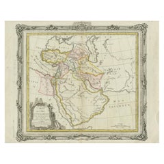
Antique Map of the Middle East with a Large Arabia, 1799
Located in Langweer, NL
Antique map titled 'Perse, Turquie Asiatique et Arabie (..)'. Map of the Middle East with a large Arabia, extending from the Black Sea to the In...
Category
Antique Late 18th Century Maps
Materials
Paper
$1,426 Sale Price
20% Off
Free Shipping
H 11.03 in W 15.63 in D 0.02 in
Finely Engraved Historical Map of Middle East and Asia, c.1745
Located in Langweer, NL
Description: Antique map titled'Theatrum Historicum pars Orientalis.'
Finely engraved historical map with a profusion of details. It shows the Middle East and Asia. Decorative ti...
Category
Antique 1740s Maps
Materials
Paper

More From This Seller
View AllMid-18th Century Hand Drawn English Farm Map on Vellum, circa 1740s
Located in San Francisco, CA
Mid-18th century hand drawn English farm map on Vellum circa 1740s
Henry Maxted & Isaac Terry, Surveyors.
A Map of a Farm in the Parish of Blean in the County of KENT: Belonging to Mrs Elizabeth Hodgson circa 1743.
A beautiful hand drawn map...
Category
Antique Mid-18th Century English Maps
Materials
Lambskin

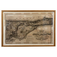
1868 Map of the Upper Part of the Island of Manhattan Above 86th Street
By Wm. Rogers Mfg. Co.
Located in San Francisco, CA
This wonderful piece of New York City history is over 150 years old. It depicts 86th street and above. It was lithographed by WC Rogers and company. It was made to show what was the Battle of Harlem during the Revolutionary war...
Category
Antique 1860s American American Colonial Maps
Materials
Paper
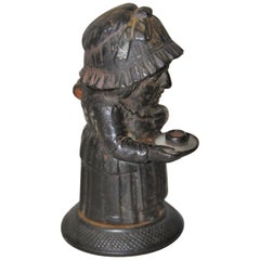
Mid-19th Century Cast Iron Match Holder by Zimmerman of Hanau Germany circa 1850
Located in San Francisco, CA
Rare mid-19th century cast iron match holder by Zimmerman of Hanau, Germany, circa 1850
This woman in her night clothes lights her way holdi...
Category
Antique Mid-19th Century German Tobacco Accessories
Materials
Iron
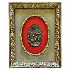
Napoleon Emperor Co. Framed Leda
the Swan Nude Relief on Brass Buckle Framed
Located in San Francisco, CA
Napoleon Emperor Co. Framed Leda & the Swan Nude Relief on Brass Buckle
8x10x2 framed
Buckle 4"x2.5"
Category
Antique 18th Century Collectible Jewelry
Materials
Brass
19th Century Shakespeare 10 Volumes, circa 1894
Located in San Francisco, CA
19th century Shakespeare 10 volumes, circa 1894
Edited by William Aldis Wright
Macmillan and Co., London and New York
Each volume measures 7" wide x 10.5" high
Offered as...
Category
Antique Late 19th Century American Books
Materials
Paper
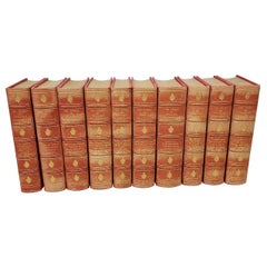
$1,650 / set
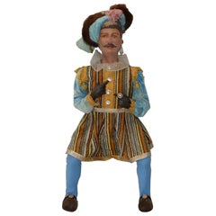
Vintage Christmas Holiday Musketeer Doll, circa 1940s-1950s
Located in San Francisco, CA
Vintage Christmas Holiday Musketeer Doll, circa 1940s-1950s
Hand painted. Handmade clothing. Very nice vintage doll. Unsure if it's wood or papier...
Category
Mid-20th Century American Toys and Dolls
Materials
Machiche
Still Thinking About These?
All Recently ViewedMore Ways To Browse
Middle East Furniture
Hand Painted Antique Map
Antique Maps Of Italy
Antique Navigator
Antique Maps Of Britain
Scotland Map
Antique Maps Scotland
Furniture Russian 18th Century
Antique Map Of Middle East
London Antique Maps
Map Colorful
Maps Of Australia
Antique Railroad Furniture
Map Of London
Antique Galleon
Antique Maps Australia
Used Nautical Charts
Antique Collectables Australia