Video Loading
Want more images or videos?
Request additional images or videos from the seller
1 of 11
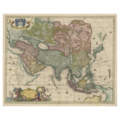
Rare Unusual Antique Map of Asia with a Landbridge from Korea to America, 1717
Price:$626.42
$842.46List Price
About the Item
- Dimensions:Height: 9.65 in (24.5 cm)Diameter: 13.39 in (34 cm)
- Materials and Techniques:Paper,Engraved
- Place of Origin:
- Period:
- Date of Manufacture:1717
- Condition:Good, given age. Neatly restored split of one of the original folds lower left; partly short-cut left margin. Original folds as issued. General age-related toning and/or occasional minor defects from handling. Please study image carefully.
- Seller Location:Langweer, NL
- Reference Number:Seller: PCT-592061stDibs: LU3054343967082
About the Seller
5.0
Recognized Seller
These prestigious sellers are industry leaders and represent the highest echelon for item quality and design.
Platinum Seller
Premium sellers with a 4.7+ rating and 24-hour response times
Established in 2009
1stDibs seller since 2017
2,836 sales on 1stDibs
Typical response time: 1 hour
Authenticity Guarantee
In the unlikely event there’s an issue with an item’s authenticity, contact us within 1 year for a full refund. DetailsMoney-Back Guarantee
If your item is not as described, is damaged in transit, or does not arrive, contact us within 7 days for a full refund. Details24-Hour Cancellation
You have a 24-hour grace period in which to reconsider your purchase, with no questions asked.Vetted Professional Sellers
Our world-class sellers must adhere to strict standards for service and quality, maintaining the integrity of our listings.Price-Match Guarantee
If you find that a seller listed the same item for a lower price elsewhere, we’ll match it.Trusted Global Delivery
Our best-in-class carrier network provides specialized shipping options worldwide, including custom delivery.You May Also Like
Antique 1803 Italian Map of Asia Including China Indoneseia India
Located in Amsterdam, Noord Holland
Antique 1803 Italian Map of Asia Including China Indoneseia India
Very nice map of Asia. 1803.
Additional information:
Type: Map
Country of Manufacturing: Europe
Period: 19th centu...
Category
Antique 19th Century European Maps
Materials
Paper

$438 Sale Price
39% Off
H 12.6 in W 15.75 in D 0.04 in
Antique French Map of Asia Including China Indoneseia India, 1783
Located in Amsterdam, Noord Holland
Very nice map of Asia. 1783 Dedie au Roy.
Additional information:
Country of Manufacturing: Europe
Period: 18th century Qing (1661 - 1912)
Condition: Overall Condition B (Good Used)...
Category
Antique 18th Century European Maps
Materials
Paper

$486 Sale Price
40% Off
H 21.26 in W 27.56 in D 0.04 in
Asia Declineatio: A 17th Century Hand-colored Map of Asia by Justus Danckerts
Located in Alamo, CA
This is a scarce 17th century beautifully hand-colored copperplate engraved map of Asia entitled “Exactissima Asiae Delineatio in Praecipuas Regiones Caerterasque Partes divisa et de...
Category
Late 17th Century Old Masters Landscape Prints
Materials
Engraving

Map of the East Indies: An Original 18th Century Hand-colored Map by E. Bowen
Located in Alamo, CA
This is an original 18th century hand-colored map entitled "An Accurate Map of the East Indies Exhibiting the Course of the European Trade both on the Continent and Islands" by Emanu...
Category
Mid-18th Century Old Masters Landscape Prints
Materials
Engraving

$1,275
H 15.75 in W 20 in
Super Rare Antique French Map of Chine and the Chinese Empire, 1780
Located in Amsterdam, Noord Holland
Super Rare Antique French Map of Chine and the Chinese Empire, 1780
Very nice map of Asia. 1780 Made by Bonne.
Additional information:
Type: Map
...
Category
Antique 18th Century European Maps
Materials
Paper

$438 Sale Price
49% Off
H 13.78 in W 10.04 in D 0.04 in
Tabula Indiae Orientalis - Etching by Frederick de Wit - 1680ca
By Frederick de Wit
Located in Roma, IT
This double-page etching with contemporary coloring, entitled Tabula Indiae orientalis, was realized by the cartographer Frederick de Wit for the famous Atlas published in Amsterdam ...
Category
1680s Modern Figurative Prints
Materials
Etching

$1,661
H 20.28 in W 23.55 in D 0.04 in
Accuratissima Totius Asiae Tabula - Etching by Frederick de Wit - 1680 ca
By Frederick de Wit
Located in Roma, IT
This double-page etching with contemporary coloring, entitled Accuratissima totius Asiae Tabula, was realized by the cartographer Frederick de Wit for the famous Atlas published in A...
Category
1680s Modern Figurative Prints
Materials
Etching

$1,661
H 20.28 in W 23.55 in D 0.04 in
China: An Original 18th Century Hand-colored Map by E. Bowen
Located in Alamo, CA
This is an original 18th century hand-colored map entitled "A New & Accurate Map of China, Drawn from Surveys made by the Jesuit Missionaries, by order of the Emperor. The whole bein...
Category
Mid-18th Century Old Masters Landscape Prints
Materials
Engraving

$1,075
H 15.75 in W 19.75 in
Antique Map - Mare Pacificum - Etching by Johannes Janssonius - 1650s
By Johannes Janssonius
Located in Roma, IT
Mare Pacificum is an antique map realized in 1650 by Johannes Janssonius (1588-1664).
The Map is Hand-colored etching, with coeval watercolorang.
Good conditions with slight foxing...
Category
1650s Modern Figurative Prints
Materials
Etching

$2,847
H 23.63 in W 19.3 in D 0.04 in
1627 Hendrik Hondius Map Entitled "Vltoniae Orientalis Pars, " Ric.a009
Located in Norton, MA
1627 Hendrik Hondius map entitled
"Vltoniae orientalis pars,"
Ric.a009
Title:
Vltoniae orientalis : pars
Title (alt.) :
Ultoniae orientalis pars
Creator:
Mercator, Gerh...
Category
Antique 17th Century Dutch Maps
Materials
Paper

$975
H 19.49 in W 23.04 in D 0.4 in
More From This Seller
View AllAntique Map of Asia and the East Indies and Korea as a Peninsula, ca.1660
Located in Langweer, NL
Antique map titled 'Asiae nova delineatio'. Decorative map of Asia and the East Indies. The map shows Korea as a peninsula. In China the Great Wall is depicted, as well as a long str...
Category
Antique 17th Century Maps
Materials
Paper
$2,373 Sale Price
20% Off
Free Shipping
Antique Duval Map of East Asia with China, Japan, Korea and the Great Wall, 1663
Located in Langweer, NL
Duval Asia Map 1663 China Japan Korea Great Wall Antique French Cartography
This elegant 17th-century map titled “L’Asie” is a finely executed French representation of the Asian continent by Pierre Duval, one of the foremost cartographers of Louis XIV’s France. Published in Paris in 1663, the map reflects a significant stage in European geographic knowledge, presenting Asia with increasing accuracy at a moment when global exploration, trade, and diplomatic contact were rapidly transforming Western understanding of the East.
Most of the place names shown represent geographical entities that still exist today or once existed historically, giving the map strong continuity between early modern geography and the modern world. Particularly notable is the improved rendering of Japan and the Korean peninsula, both shown with greater accuracy than in earlier 16th-century maps. The lower islands of Japan are better proportioned, and Korea is clearly depicted as a peninsula rather than an island, marking an important correction in European cartography.
China dominates the interior of the continent and is richly detailed with provinces, river systems, and cities. One of the most appealing features is the visible tracing of the Great Wall of China...
Category
Antique Mid-17th Century French Maps
Materials
Paper
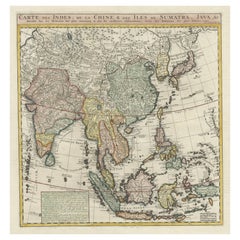
Detailed Original Antique Map of India, Southeast Asia and the Far East, 1719
Located in Langweer, NL
Antique map titled 'Carte des Indes, de la Chine & des Iles de Sumatra, Java & c'.
Detailed map of India, Southeast Asia and the Far East, extending from Gujerat to the supposed "T...
Category
Antique 1710s Maps
Materials
Paper
Large Antique Map of Asia including All of Southeast Asia, c.1792
Located in Langweer, NL
Antique map titled 'L' Asie Divisee en ses Empires, Royaumes, et Etats'. Attractive, large map of Asia including all of Southeast Asia. The cartography is archaic for the period with...
Category
Antique 18th Century Maps
Materials
Paper

Map of Southeast Asia, Extending from India to Tibet
Japan to New Guinea, 1640
Located in Langweer, NL
Antique map titled 'India quae Orientalis dicitur et Insulae adiacentes'.
Map of Southeast Asia, extending from India to Tibet to Japan to New Guinea. This map is one of the firs...
Category
Antique 1640s Maps
Materials
Paper
$2,515 Sale Price
20% Off
Antique Map of Asia by Tirion
c.1760
Located in Langweer, NL
Antique map titled 'Nuova Carta dell Asia'. Decorative map of Asia. Published by I. Tirion, circa 1760.
Category
Antique Mid-18th Century Maps
Materials
Paper

Still Thinking About These?
All Recently ViewedMore Ways To Browse
18th Century American Antiques
Great Wall China
Terre De Fer
Leather Pouf And Ottomans
Low Side Tables
Set Of Four Italian Dining Chairs
Silk Runner Carpet
3x5 Rugs
Italian Lacquer Dining Room Sets
Round Brass Table
Round Table Base
Belgian Antiques
Cream Soup
Early English Silver
James Bond
Paisley Rugs and Carpets
Antique Pagoda
Black And Chrome Lounge Chair