Items Similar to Relief Atlas Map of Europe by Hachette – Antique French Map c.1883


Video Loading
Want more images or videos?
Request additional images or videos from the seller
1 of 11
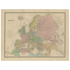
Relief Atlas Map of Europe by Hachette – Antique French Map c.1883
$467.16
£349.33
€390
CA$643.62
A$701.96
CHF 371.85
MX$8,415.54
NOK 4,735.75
SEK 4,330.49
DKK 2,971.96
About the Item
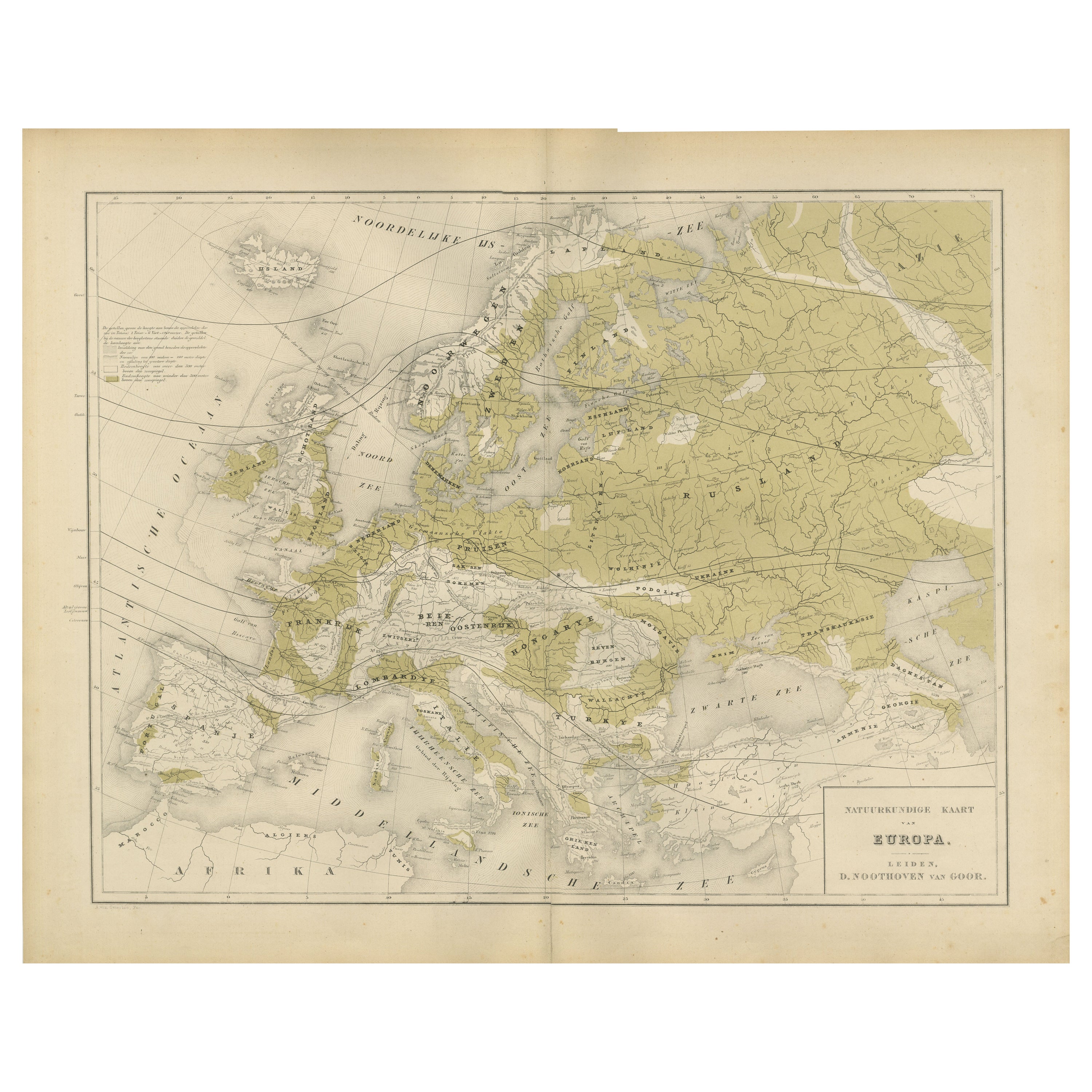
Antique Map of Europe – Physical Relief Map by Hachette, circa 1883
Description:
This antique map titled “Europe Physique” was published by Hachette in Paris around 1883 and originates from their educational “Atlas en relief.” The map illustrates the physical geography of Europe with hypsometric tinting, highlighting elevation variations across the continent.
Depicted are major mountain ranges such as the Alps, Pyrenees, Carpathians, Balkans, and Ural Mountains, using brown tones for higher elevations and green for lowlands and plains. Rivers, lakes, and key coastal features are clearly marked, including the Mediterranean, North Sea, Baltic Sea, and Atlantic coasts. The relief shading provides a vivid sense of Europe’s topography, making it ideal for both geographical study and decorative display.
At the lower margin is the publication detail: “E. Hachette, Editeur, 79, Rue Serpente, à Paris.” The title “Europe Physique” is placed at the top, with a colour key explaining altitude ranges to the left. This map reflects the high cartographic standards of late 19th-century French educational atlases, created to enhance geographical understanding in schools and universities.
Condition:
Good condition with original pastel colouring. Minor foxing in the wide margins and light toning consistent with age. The printed area remains clean and well-preserved.
Framing tip:
This physical map of Europe will look excellent when float-mounted in a black or dark wood frame to accentuate the earthy colour palette. It is a fine addition to antique map collections, office libraries, or classical study walls, especially for collectors interested in educational cartography and 19th-century European history.
- Dimensions:Height: 10.12 in (25.7 cm)Width: 12.84 in (32.6 cm)Depth: 0.01 in (0.2 mm)
- Materials and Techniques:
- Place of Origin:
- Period:
- Date of Manufacture:circa 1883
- Condition:Good condition with original pastel colouring. Minor foxing in the wide margins and light toning consistent with age. The printed area remains clean and well-preserved.
- Seller Location:Langweer, NL
- Reference Number:Seller: BG-13384-341stDibs: LU3054345657922
About the Seller
5.0
Recognized Seller
These prestigious sellers are industry leaders and represent the highest echelon for item quality and design.
Platinum Seller
Premium sellers with a 4.7+ rating and 24-hour response times
Established in 2009
1stDibs seller since 2017
2,791 sales on 1stDibs
Typical response time: <1 hour
- ShippingRetrieving quote...Shipping from: Langweer, Netherlands
- Return Policy
More From This Seller
View AllAntique Map of Europe, 1903, with Intricate Political Boundaries and Rich Detail
Located in Langweer, NL
Title: Antique Map of Europe, 1903, with Intricate Political Boundaries and Rich Detail
Description:
This antique map, titled "Europe," is a finely engraved and beautifully colored ...
Category
Early 20th Century Maps
Materials
Paper

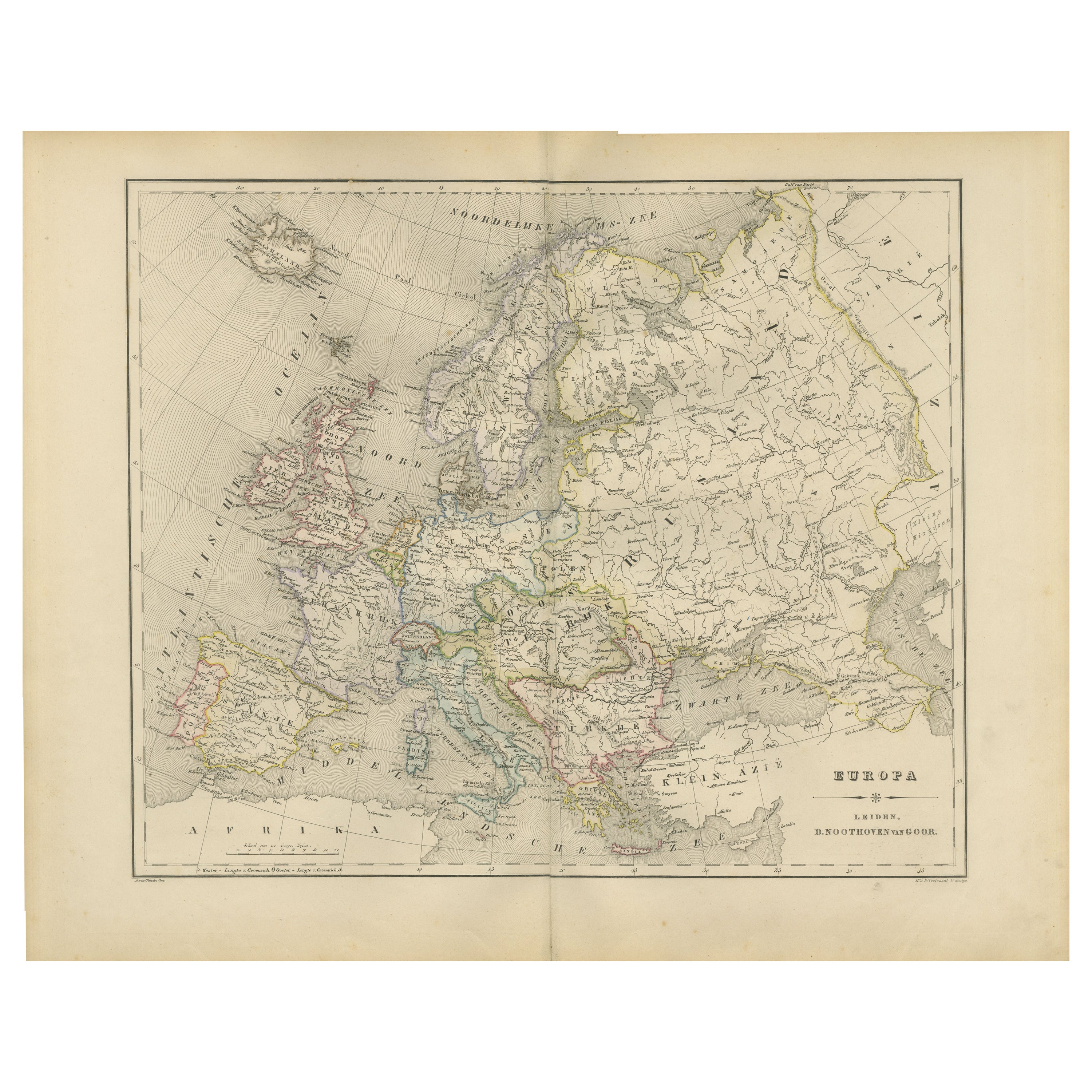
Political Map of Europe – Nieuwe Hand-Atlas by Frijlink
van Otterloo, 1876
Located in Langweer, NL
Title: Political Map of Europe – Nieuwe Hand-Atlas by Frijlink & van Otterloo, 1876
Description:
This 19th-century Dutch map titled “Europa” was published in 1876 in the Nieuwe Hand...
Category
Antique 1870s Dutch Maps
Materials
Paper
Physical Map of Europe – Nieuwe Hand-Atlas by Frijlink
van Otterloo, 1876
Located in Langweer, NL
Title: Northern Hemisphere Map Centered on the North Pole, Leiden 1876
Description:
This 19th-century Dutch map titled “Noordpoolkaart” (Map of the North Pole) was published in 1876...
Category
Antique 1870s Dutch Maps
Materials
Paper
Antique Map of Europe – Political Divisions by Andriveau-Goujon, Paris 1861
Located in Langweer, NL
Antique Map of Europe – Political Divisions by Andriveau-Goujon, Paris 1861
This beautifully engraved and hand-colored antique map of Europe was published in 1861 by the Parisian ca...
Category
Antique Mid-19th Century French Maps
Materials
Paper
Antique Map of Europe by W. G. Blackie, 1859
Located in Langweer, NL
Antique map titled 'Europe'. Original antique map of Europe. This map originates from ‘The Imperial Atlas of Modern Geography’. Published by W. G. Blackie, 1859.
Category
Antique Mid-19th Century Maps
Materials
Paper

$239 Sale Price
20% Off
Antique Europe Map with Political Boundaries – Collectible Wall Art, 1884
Located in Langweer, NL
Antique Map of Europe with Political Divisions – Black’s Atlas, 1884
This detailed engraved map of Europe was published in the New and Revised Edition of Black’s General Atlas of th...
Category
Antique 1880s Scottish Maps
Materials
Paper
You May Also Like
Russia in Europe with Poland and Finland. Century Atlas antique vintage map
Located in Melbourne, Victoria
'The Century Atlas. Russia in Europe with Poland and Finland'
Original antique map, 1903.
Central fold as issued. Map name and number printed on the reverse corners.
Sheet 40cm by ...
Category
Early 20th Century Victorian More Prints
Materials
Lithograph

Russia, Western and Southern Part. Century Atlas antique vintage map
Located in Melbourne, Victoria
'The Century Atlas. Russia, Western and Southern Part'
Original antique map, 1903.
Inset map tilted 'St Petersburg and Environs'.
Central fold as issued. Map name and number printe...
Category
Early 20th Century Victorian More Prints
Materials
Lithograph

Large Original Antique Map of Europe by Sidney Hall, 1847
Located in St Annes, Lancashire
Great map of Europe
Drawn and engraved by Sidney Hall
Steel engraving
Original colour outline
Published by A & C Black. 1847
Unframed
Free shipping.
Category
Antique 1840s Scottish Maps
Materials
Paper

France, Northern Part. Century Atlas antique map
Located in Melbourne, Victoria
'The Century Atlas. France, Northern Part.'
Original antique map, 1903.
Inset maps of 'France in Provinces' and 'Paris and Vicinity'.
Central fold as issued. Map name and number pr...
Category
Early 20th Century Victorian More Prints
Materials
Lithograph

Original Antique Map of Europe, Arrowsmith, 1820
Located in St Annes, Lancashire
Great map of Europe
Drawn under the direction of Arrowsmith.
Copper-plate engraving.
Published by Longman, Hurst, Rees, Orme and Brown, 1820
...
Category
Antique 1820s English Maps
Materials
Paper

1790 Thomas Stackhouse Map, Entitled "Russia in Europe, " , Ric.a004
Located in Norton, MA
1790 Thomas Stackhouse map, entitled
"Russia in Europe"
Ric.a004
Stackhouse, Thomas
Russia in Europe [map]
London: T. Stackhouse, 1783. Map. Matted hand-colored copper engraving. Image size: 14.5 x 15.25 inches. Mat size: 22.75 x 23.75 inches. A beautiful example of this map of Eastern Europe...
Category
Antique 17th Century Unknown Maps
Materials
Paper

More Ways To Browse
French Relief
Library Collection
Antique Victorian Dining Tables
Italian Plastic Chairs
Black Crystal Glasses
French Mid Century Modern Rug
China Silk Rug
Chrome Glass Coffee Tables
Antique Italian Chairs
Antique Walnut Bar
Beni Ourain Rugs
French Iron And Glass Table
Glass Top Wood Base Coffee Tables
T Chair
Antique Silver Basket
Antique Walkers
Ebony Wood Furniture
Opalescent Glass