Items Similar to River Sanaga, West Africa – Elegant French Exploration Map, c.1750


Want more images or videos?
Request additional images or videos from the seller
1 of 9
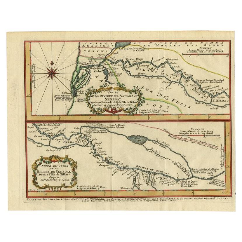
River Sanaga, West Africa – Elegant French Exploration Map, c.1750
$752.36
£562.17
€630
CA$1,037.76
A$1,136.84
CHF 598.39
MX$13,568.44
NOK 7,627.91
SEK 6,973.06
DKK 4,800.11
About the Item
Nubia and Abyssinia – Venetian Map of Northeast Africa, Zatta, 1784
This detailed late-18th-century map depicts Nubia and Abyssinia, covering large parts of present-day Sudan, Ethiopia, Eritrea, and the Horn of Africa. The map is titled “La Nubia ed Abissinia” and was published in Venice in 1784 by Antonio Zatta, one of the most important Italian map publishers of the period. It forms part of Zatta’s monumental Atlante Novissimo, produced with the privilege of the Venetian Senate.
The map presents the Nile basin in exceptional detail, tracing the river from its upper reaches through Nubia toward Egypt, while also mapping the Red Sea coast, inland mountain ranges, deserts, and regional kingdoms. Political and regional boundaries are outlined in contemporary hand color, distinguishing Nubia, Abyssinia, and neighboring territories. Numerous towns, tribal regions, rivers, and topographical features are carefully named, reflecting the synthesis of classical sources, Jesuit reports, and more recent travel accounts available to European geographers in the late Enlightenment period.
Zatta’s cartography represents the Italian continuation of the scientific mapping tradition pioneered by Delisle and d’Anville, emphasizing clarity, proportional accuracy, and critical compilation of sources. While interior Africa remained imperfectly known, this map shows a marked departure from earlier speculative geography, replacing legend with measured structure and comparative reasoning.
The decorative title cartouche, engraved in a restrained architectural style, anchors the upper right and reflects the sober elegance characteristic of Venetian Enlightenment cartography. Latitude and longitude lines, clean engraving, and balanced composition give the map strong visual presence without excess ornamentation.
This map is particularly appealing to collectors of African cartography, Nile exploration history, Ethiopian history, and Enlightenment-era geography. It also serves as an excellent intellectual counterpart to earlier French coastal and regional charts of Africa, illustrating the progression of European geographic knowledge during the 18th century.
Condition report
Good condition overall. Central vertical fold as issued. Light age toning and some mild discoloration, more noticeable along the fold. Minor scattered spots and faint handling marks. Original outline hand color. Plate mark visible. Margins intact.
Framing tips
A wide off-white or light sand-colored mat is recommended to balance the dense interior detail and preserve visual calm. A medium to dark wood frame enhances the engraved line work and complements the restrained hand coloring. Particularly effective as a scholarly centerpiece or paired with Indian Ocean or Nile-related maps.
Technique: Copper engraving with contemporary outline hand color
Maker: Antonio Zatta, Venice, 1784
Keywords: Nubia map, Abyssinia map, Ethiopia antique map, Northeast Africa cartography, Nile map, Blue Nile, White Nile, Red Sea map, Horn of Africa, Ethiopian Highlands, Kingdom of Nubia, Kingdom of Abyssinia, Gondar, Axum, Aksum, Sennar, Dongola, Suakin, Massawa, Zeila, Bab el Mandeb, Red Sea trade routes, Mecca, Mekka, Meca, Arabian Peninsula, African exploration map, 18th century map Africa, Venetian map, Antonio Zatta, Atlante Novissimo, Enlightenment cartography, antique engraved map
- Dimensions:Height: 13.67 in (34.7 cm)Width: 17.21 in (43.7 cm)Depth: 0.01 in (0.2 mm)
- Materials and Techniques:Paper,Engraved
- Place of Origin:
- Period:1750-1759
- Date of Manufacture:circa 1750
- Condition:Good condition overall. Central vertical fold as issued. Light age toning and some mild discoloration, more noticeable along the fold. Minor scattered spots and faint handling marks. Original outline hand color. Plate mark visible. Margins intact.
- Seller Location:Langweer, NL
- Reference Number:Seller: BG-14128-61stDibs: LU3054348017042
About the Seller
5.0
Recognized Seller
These prestigious sellers are industry leaders and represent the highest echelon for item quality and design.
Platinum Seller
Premium sellers with a 4.7+ rating and 24-hour response times
Established in 2009
1stDibs seller since 2017
2,809 sales on 1stDibs
Typical response time: 1 hour
- ShippingRetrieving quote...Shipping from: Langweer, Netherlands
- Return Policy
More From This Seller
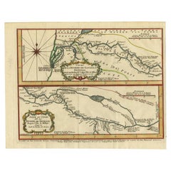
View AllAntique Map of the Sanaga River, Senegal, 1747
Located in Langweer, NL
Antique map titled 'Cours De La Riviere De Sanaga Ou Senegal (..) - Kaart van den Loop der Riviere Sanaga (..)'. Attractive double map of the Sanaga River, Senegal, Africa. This map ...
Category
Antique 18th Century Maps
Materials
Paper
Antique Map of the Gambia River by J. Van Schley, circa 1750
Located in Langweer, NL
"Carte de la Riviere de Gambra ou Gambie. Depuis son Embouchure Jusqu a Eropina". Orig. copper-engraving after Capt. J. Leach's map of the region from 1732. With ornamental title cartouche and Dutch...
Category
Antique Mid-18th Century Maps
Materials
Paper

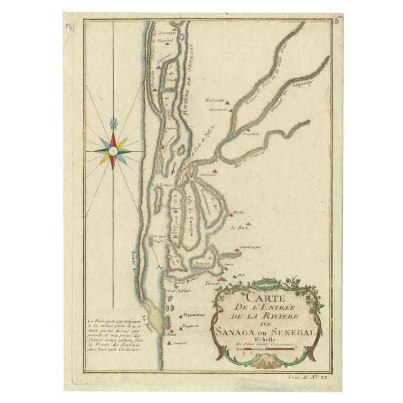
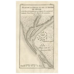
Antique Map of The Senegal River by Bellin, 1746
Located in Langweer, NL
Antique map titled 'Carte de l'Entrée de la Rivière de Sanaga ou Senegal'. Map of the mouth of the Senegal River. This map originates from Prevost's 'Histoire Generale des Voyages'. ...
Category
Antique 18th Century Maps
Materials
Paper
$224 Sale Price
20% Off
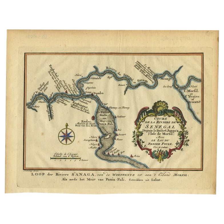
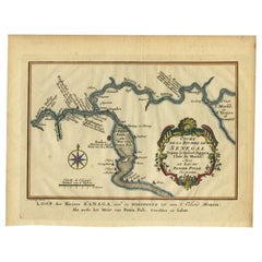
Antique Map of the Course of the Sanaga River by Van Schley, 1747
Located in Langweer, NL
Antique map titled 'Cours de la Riviere de Senegal (..) - Loop der Riviere Sanaga (..)'. Original antique map of the course of the Sanaga River that forms the border between Senegal ...
Category
Antique 18th Century Maps
Materials
Paper
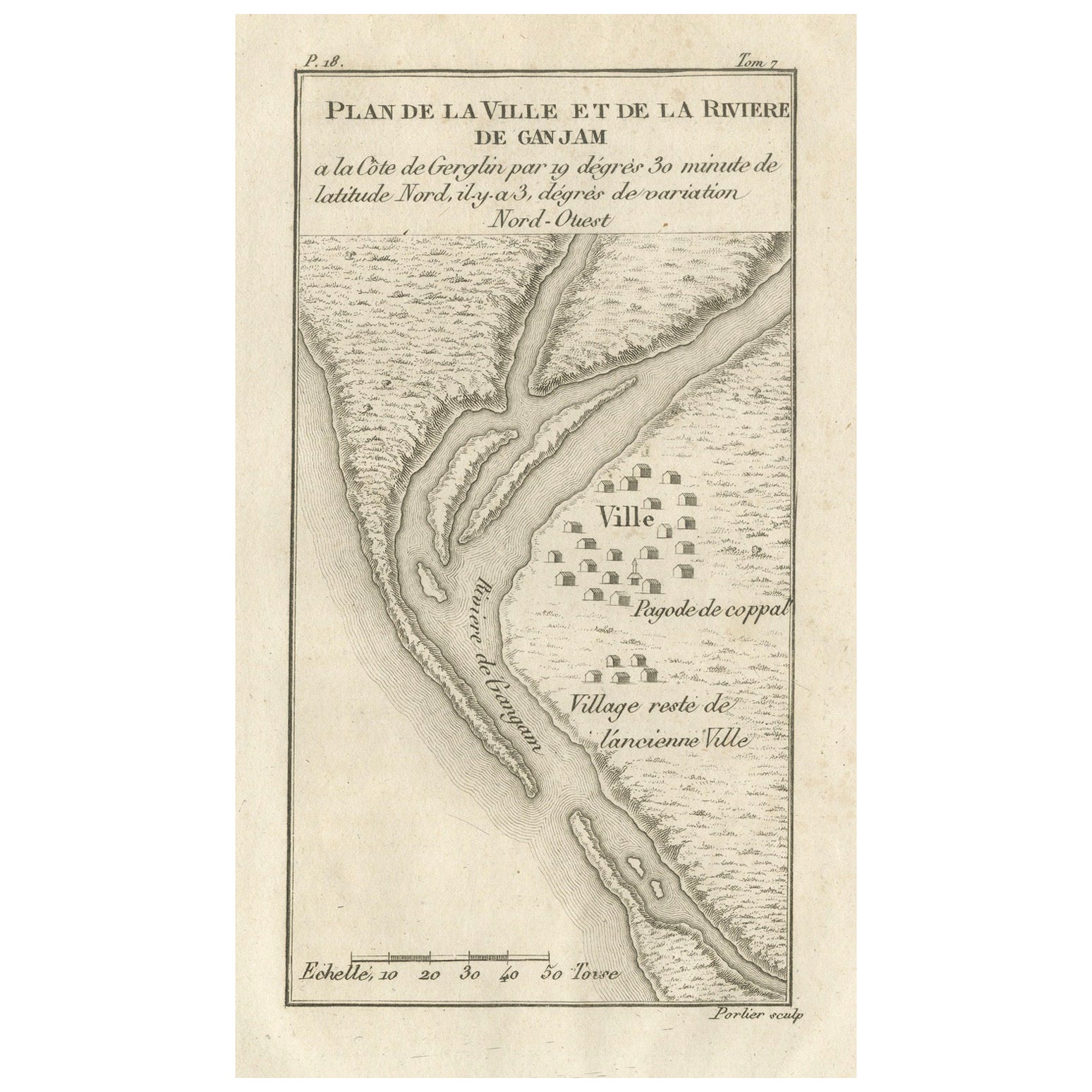
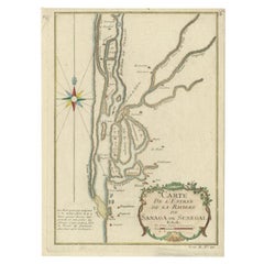
Plan of the Town and River of Ganjam, India – Antique French Map by Portier 1790
Located in Langweer, NL
Plan of the Town and River of Ganjam, India – Antique French Map by Portier, c.1790
This antique French engraving shows a detailed plan of the town and river of Ganjam, located on t...
Category
Antique Late 18th Century French Maps
Materials
Paper
Antique Map of the Tunquin River and Bay, Siam, 1757
Located in Langweer, NL
Antique map titled ‘Carte du Cours de la Riviere de Tunquin Depuis Cacho jusqu'à la Mer’. Detailed map of the Tunquin River and Bay, extending north to Cacho, the capital city. Made ...
Category
Antique 18th Century French Maps
Materials
Paper

You May Also Like
West Coast of Africa, Guinea
Sierra Leone: An 18th Century Map by Bellin
By Jacques-Nicolas Bellin
Located in Alamo, CA
Jacques Bellin's copper-plate map entitled "Partie de la Coste de Guinee Dupuis la Riviere de Sierra Leona Jusquau Cap das Palmas", depicting the coast of Guinea and Sierra Leone in ...
Category
Antique Mid-18th Century French Maps
Materials
Paper

$460 Sale Price
20% Off
West Africa Entitled "Guinea Propria": An 18th Century Hand Colored Homann Map
By Johann Baptist Homann
Located in Alamo, CA
This is a scarce richly hand colored copper plate engraved map of Africa entitled "Guinea Propria, nec non Nigritiae vel Terrae Nigrorum Maxima Pars" by Johann Baptist Homann (1664-1...
Category
Antique Mid-18th Century German Maps
Materials
Paper

$1,500 Sale Price
20% Off
West Coast of Africa; Guinea
Sierra Leone: Bellin 18th Century Map
Located in Alamo, CA
This is a Jacques Bellin copper-plate map entitled "Partie de la Coste de Guinee Dupuis la Riviere de Sierra Leona Jusquau Cap das Palmas", depicting the coast of Guinea and Sierra L...
Category
1740s Old Masters Landscape Prints
Materials
Engraving

West Africa: 18th Century Hand-colored Homann Map Entitled "Guinea Propria"
By Johann Baptist Homann
Located in Alamo, CA
This is a scarce richly hand colored copper plate engraved map of Africa entitled "Guinea Propria, nec non Nigritiae vel Terrae Nigrorum Maxima Pars" by Johann Baptist Homann (1664-1...
Category
1740s Other Art Style Prints and Multiples
Materials
Engraving

1640 Joan Bleau Map Entitled"Diocecese de rheims et le pais de rethel, " Eic.a011
Located in Norton, MA
1640 Joan Bleau map entitled
"Diocecese de rheims et le pais de rethel,"
Ric.a011
OAN BLAEU
Diocecese de Rheims, et le pais de Rethel.
Handcolored engraving, c.1640.
...
Category
Antique 17th Century Dutch Maps
Materials
Paper

Map Holy Land La Terre Sainte Engraved van Loon Published N de Fer 1703 French
Located in BUNGAY, SUFFOLK
La Terre Sainte, The Holy Land, Tiree Des Memoires De M.De.La Rue. Par N. de Fer. Geographe de Sa Majeste Catoliq et de Monseigneur le Dauphin. Avec Privil du Roi 1703
Detailed map of the Holy Land from Nicholas de Fer's L'Atlas Curieux ou le Monde. East is oriented at the top.
MAKER Nicolas de Fer 1646-1720
The French cartographer and engraver, Nicolas de Fer, was a master at creating maps that were works of art. The maps that he published were printed during the Baroque period when the decorative arts were characterized by ornate detail. De Fer’s detailed maps and atlases were valued more for their decorative content than their geographical accuracy.
Nicolas de Fer was born in 1646. His father, Antoine de Fer, owned a mapmaking firm. At the age of twelve, Nicolas was apprenticed to a Parisian engraver named Louis Spirinx. The family business was starting to decline when his father died in 1673. Nicolas de Fer’s mother, Genevieve, took over the business after the death of her husband. In 1687 the business was passed on to Nicolas and the profits increased after he took over the firm. Nicolas de Fer was a prolific cartographer who produced atlases and hundreds of single maps. He eventually became the official geographer to King Louis XIV of France and King Philip V...
Category
Antique Early 1700s French Louis XIV Maps
Materials
Paper
