Want more images or videos?
Request additional images or videos from the seller
1 of 7
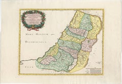
Sacred Map of the Promised Land, Twelve Tribes of Israel, Sanson, 1705
Price:$460.78
$575.98List Price
About the Item
- Dimensions:Height: 9.65 in (24.5 cm)Width: 12.49 in (31.7 cm)Depth: 0.01 in (0.2 mm)
- Materials and Techniques:Paper,Engraved
- Period:1700-1709
- Date of Manufacture:1705
- Condition:The engraving lines remain sharp, the hand coloring is vibrant, and the paper is clean with minimal signs of age. A fine example of early 18th-century cartography, it is perfect for collectors and historians focused on Biblical geography.
- Seller Location:Langweer, NL
- Reference Number:Seller: BG-139141stDibs: LU3054342680602
About the Seller
5.0
Recognized Seller
These prestigious sellers are industry leaders and represent the highest echelon for item quality and design.
Platinum Seller
Premium sellers with a 4.7+ rating and 24-hour response times
Established in 2009
1stDibs seller since 2017
2,819 sales on 1stDibs
Typical response time: 1 hour
Authenticity Guarantee
In the unlikely event there’s an issue with an item’s authenticity, contact us within 1 year for a full refund. DetailsMoney-Back Guarantee
If your item is not as described, is damaged in transit, or does not arrive, contact us within 7 days for a full refund. Details24-Hour Cancellation
You have a 24-hour grace period in which to reconsider your purchase, with no questions asked.Vetted Professional Sellers
Our world-class sellers must adhere to strict standards for service and quality, maintaining the integrity of our listings.Price-Match Guarantee
If you find that a seller listed the same item for a lower price elsewhere, we’ll match it.Trusted Global Delivery
Our best-in-class carrier network provides specialized shipping options worldwide, including custom delivery.You May Also Like
Map Holy Promise Land Canaan Richard Palmer Richard Blome 1687 Joseph Moxon
Located in BUNGAY, SUFFOLK
Canaan comonly called the Holy Land or the Land of Promise, being the Possesion of the Israelites & travelled through by Our Lord & Saviour Iesus Christ and his Apostles. Engraven by Richard Palmer for Richard Blome. 1687
Blome, Richard, 1641-1705. London. 283 x 452 mm. Copperplate.
Probably from an English Bible...
Category
Antique 17th Century British Baroque Maps
Materials
Paper

$4,129
H 12.21 in W 19.69 in D 0.4 in
The Normandy Region of France: A 17th C. Hand-colored Map by Sanson and Jaillot
By Nicolas Sanson
Located in Alamo, CA
This large hand-colored map entitled "Le Duché et Gouvernement de Normandie divisée en Haute et Basse Normandie en divers Pays; et par evêchez, avec le Gouvernement General du Havre ...
Category
Antique 1690s French Maps
Materials
Paper

$1,900 Sale Price
20% Off
H 24.88 in W 38 in D 0.13 in
1705 Golfe de Mexico and Florida Framed Map
Located in Stamford, CT
Framed map of Mexico & Florida circa 1705, Paris. Small map with Mexico and the Gulf Coast. Inset text indicating Panama, Acapulco, Mexico City and the Mississippi. Extends North to ...
Category
Antique Early 1700s French Spanish Colonial Maps
Materials
Glass, Wood, Paper

17th Century Map of Denmark by French Cartographer Sanson, Dated 1658
By Nicolas Sanson
Located in Copenhagen, K
17th century map of Denmark by French cartographer Sanson.
Nicolas Sanson (20 December 1600-7 July 1667) was a French cartographer, termed by some the creator of French geography an...
Category
Antique 17th Century French Maps
Materials
Paper

$1,750
H 18.51 in W 23.23 in D 0.4 in
Large Original Vintage Map of Israel, circa 1920
Located in St Annes, Lancashire
Great map of Israel
Original color.
Good condition
Published by Alexander Gross
Unframed.
Category
Vintage 1920s English Edwardian Maps
Materials
Paper

"Africa Vetus": a 17th Century Hand-Colored Map by Sanson
By Nicolas Sanson
Located in Alamo, CA
This original hand-colored copperplate engraved map of Africa entitled "Africa Vetus, Nicolai Sanson Christianiss Galliar Regis Geographi" was originally created by Nicholas Sanson d...
Category
Antique Late 17th Century French Maps
Materials
Paper

$1,100 Sale Price
20% Off
H 18 in W 24 in D 0.13 in
The Holy Land at the Time of Jesus: A 17th Century Dutch Map by Visscher
By Nicolaes Visscher II
Located in Alamo, CA
This detailed Dutch map entitled "Het Beloofe de Landt Canaan door wandelt van onsen Salichmaecker Iesu Christo, nessens syne Apostelen" by Nicolaes Visscher was published in Amsterd...
Category
Antique Mid-17th Century Dutch Maps
Materials
Paper

$1,020 Sale Price
20% Off
H 22.75 in W 28.5 in D 1.13 in
Greece, "Graeciae Antiquae"" A 17th Century Hand-colored Map by Sanson
By Nicolas Sanson
Located in Alamo, CA
This is an original 17th century hand colored copperplate engraved map of Greece entitled "Graeciae Antiquae Tabula Hanc Geographicam" by Nicolas d'Abbeville Sanson, engraved and pub...
Category
Antique Mid-17th Century French Maps
Materials
Paper

$1,260 Sale Price
20% Off
H 24.75 in W 29.75 in D 0.13 in
Africa: A Large 17th Century Hand-Colored Map by Sanson and Jaillot
By Nicolas Sanson
Located in Alamo, CA
This large original hand-colored copperplate engraved map of Africa entitled "L'Afrique divisee suivant l'estendue de ses principales parties ou sont distingues les uns des autres, L...
Category
Antique 1690s French Maps
Materials
Paper

$1,740 Sale Price
20% Off
H 24.88 in W 38 in D 0.13 in
Southern Greece: A Large 17th C. Hand-colored Map by Sanson and Jaillot
By Nicolas Sanson
Located in Alamo, CA
This large original hand-colored copperplate engraved map of southern Greece and the Pelopponese Peninsula entitled "La Moree Et Les Isles De Zante, Cefalonie, Ste. Marie, Cerigo & C...
Category
Antique 1690s French Maps
Materials
Paper

$1,580 Sale Price
20% Off
H 24.88 in W 38 in D 0.13 in
More From This Seller
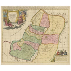
View AllHoly Land Map of the Twelve Tribes of Israel – Sanson, Hand Colored, 1696
Located in Langweer, NL
Holy Land Map of the Twelve Tribes of Israel – Sanson, Hand Colored, 1696
Description:
This impressive and richly hand-colored map of the Holy Land depicts the biblical territories ...
Category
Antique Late 17th Century French Maps
Materials
Paper
Holy Land Map of the Twelve Tribes of Israel, After Sanson, Paris c.1798
Located in Langweer, NL
Holy Land, Twelve Tribes of Israel – After Nicolas Sanson, De Vaugondy / Delamarche, c.1798
Description:
Holy Land. De Vaugondy (G. R.), Carte de la Terre des Hébreux ou Israélites,...
Category
Antique Late 18th Century French Maps
Materials
Paper

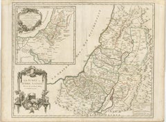
Judaea or Terra Sancta, Twelve Tribes of Israel – Sanson Map, c.1680
Located in Langweer, NL
Judaea or Terra Sancta, Twelve Tribes of Israel – Sanson Map, c.1680
This antique map depicts Judaea or the Holy Land divided among the Twelve Tribes of Israel, based on biblical ge...
Category
Antique Late 17th Century Dutch Maps
Materials
Paper
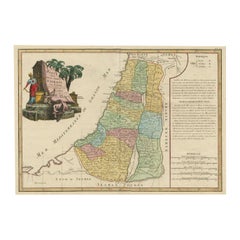
Antique French Map of the Holy Land, Twelve Tribes of Israel, c.1750
Located in Langweer, NL
Antique Holy Land Map, Twelve Tribes of Israel – Robert de Vaugondy, c.1750
Description
This finely engraved and hand-colored map depicts Judea, or the Holy Land, divided according ...
Category
Antique Mid-18th Century French Maps
Materials
Paper
Original Rare Map of the Holy Land Showing the Twelve Tribes of Israel
s, 1782
Located in Langweer, NL
Antique map titled 'Carte des Douze Tribus D'Israel (..).'
Map of the Holy Land showing the twelve tribes of Israel's. Tribes are all named...
Category
Antique 1780s Maps
Materials
Paper
$662 Sale Price
20% Off
Antique Holy Land Map, Twelve Tribes of Israel – Covens
Mortier, c.1700
Located in Langweer, NL
Antique Holy Land Map, Twelve Tribes of Israel – Covens
Mortier, c.1700
Description:
This finely engraved early 18th-century map depicts the Holy Land divided according to the...
Category
Antique Early 18th Century French Maps
Materials
Paper

Still Thinking About These?
All Recently ViewedMore Ways To Browse
Jerusalem Engraving
Blue Green Wool And Silk Rug
Brown Sheepskin Chair
Vintage Brass Bar Carts
Antique Botanical Prints
Green Persian Rug
50 X 50 Coffee Table
Milo Baughman 1970
Spanish Baroque Furniture
Stone China
Couch Console
Vintage Burn
Chinese Stone
Sterling Silver Flatware Service For 12
Antique Dining Tables With Leaves
Decorative Wall Panels
Frank Lloyd Wright For Cassina
Natural Curved