Items Similar to Saint-Domingue (French Section): 18th Century Map from France Militaire Series


Want more images or videos?
Request additional images or videos from the seller
1 of 7
Saint-Domingue (French Section): 18th Century Map from France Militaire Series
$114.89
$143.6120% Off
£86.01
£107.5120% Off
€96
€12020% Off
CA$158.16
CA$197.6920% Off
A$172.90
A$216.1220% Off
CHF 91.47
CHF 114.3420% Off
MX$2,068.97
MX$2,586.2120% Off
NOK 1,163.82
NOK 1,454.7720% Off
SEK 1,065.36
SEK 1,331.7020% Off
DKK 731.40
DKK 914.2520% Off
About the Item
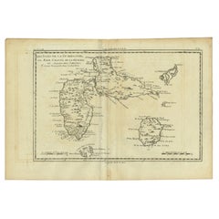
This map is titled "St. Domingue (Partie Française)" and is part of the France Militaire series. It focuses on the French portion of Saint-Domingue, which corresponds to modern-day Haiti.
Features:
- The map provides a detailed view of the French colonial territory in Saint-Domingue, the western part of the island of Hispaniola, known for being one of France’s most profitable colonies during the 18th century due to its sugar and coffee plantations.
- Key cities and regions are marked, including Port-au-Prince, Cap Français (now Cap-Haïtien), and the Île de la Gonâve.
- The geographical features are represented with great detail, including mountain ranges, rivers, and coastal regions. Important bays such as the Baie de Port-au-Prince are also labeled.
- To the left, the map includes part of Cuba, highlighting how close the island is to Saint-Domingue.
Historical Context:
- The map likely dates to the late 18th century or early 19th century, around the time of the Haitian Revolution (1791–1804), which led to the independence of Haiti from France.
- The title "France Militaire" suggests that this map may have been used for military purposes, possibly related to French colonial administration or military campaigns during the turbulent period of the Haitian Revolution.
Artistic and Cartographic Details:
- The map is finely engraved, with detailed line work showcasing both natural and urban features.
- It was drawn by Monin and engraved by Jacqueline and Barrière, well-known cartographers and engravers of the time.
The map of **Saint-Domingue (Partie Française)** from the **France Militaire** series likely dates to the **late 18th century or early 19th century**, specifically around **1790 to 1804**.
This period corresponds with significant historical events, including the Haitian Revolution (1791-1804), during which Haiti (formerly the French colony of Saint-Domingue) gained its independence from France. The title "France Militaire" suggests that the map was created for military or administrative purposes, possibly in relation to French efforts to maintain control over the colony during the revolution.
Given these factors, the map most likely dates between 1790 and 1800, during the last years of French control over Saint-Domingue.
- Dimensions:Height: 7.17 in (18.2 cm)Width: 10.83 in (27.5 cm)Depth: 0 in (0.02 mm)
- Materials and Techniques:
- Period:1790-1799
- Date of Manufacture:circa 1790
- Condition:Condition: good, given age. General age-related toning and/or occasional minor defects from handling. Please study scan carefully.
- Seller Location:Langweer, NL
- Reference Number:Seller: BG-13093-251stDibs: LU3054341482282
About the Seller
5.0
Recognized Seller
These prestigious sellers are industry leaders and represent the highest echelon for item quality and design.
Platinum Seller
Premium sellers with a 4.7+ rating and 24-hour response times
Established in 2009
1stDibs seller since 2017
2,793 sales on 1stDibs
Typical response time: <1 hour
- ShippingRetrieving quote...Shipping from: Langweer, Netherlands
- Return Policy
More From This Seller
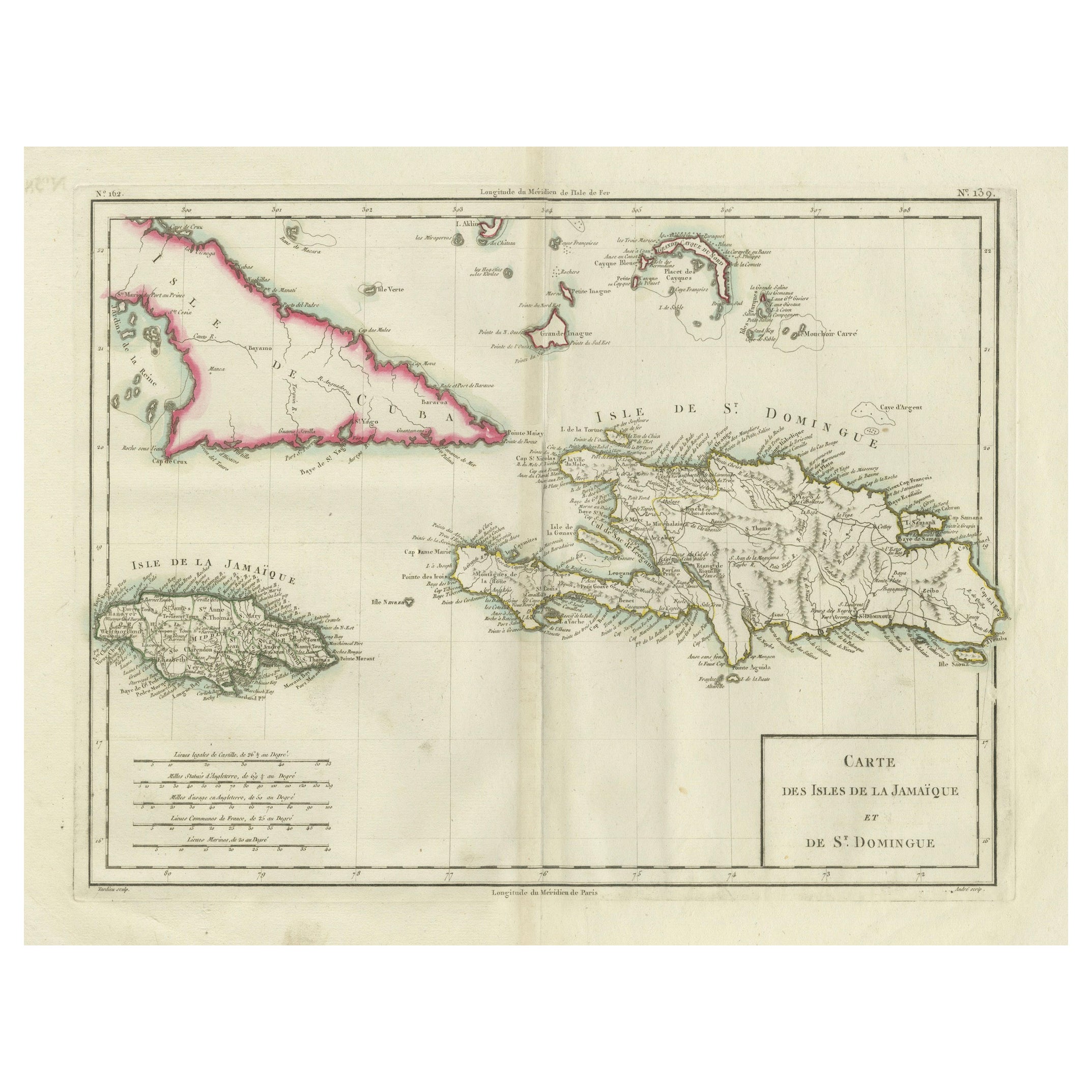
View AllAntique Map of Jamaica and Hispaniola (Saint-Domingue and Santo Domingo), 1802
Located in Langweer, NL
This is an original antique map titled "Carte des Isles de la Jamaïque et de St. Domingue," depicting the islands of Jamaica and Saint-Domingue (modern-day Haiti and the Dominican Re...
Category
Antique Early 1800s Maps
Materials
Paper

$536 Sale Price
20% Off
Authentic Antique Map of the Caribbean, Gulf Coast and Central America, 1787
Located in Langweer, NL
Antique map titled 'Les Isles Antilles et le Golfe du Méxique'. Original old map of the Caribbean, Gulf Coast and Central America. With inset map of Bermuda...
Category
Antique Late 18th Century Maps
Materials
Paper

$296 Sale Price
20% Off
Free Shipping
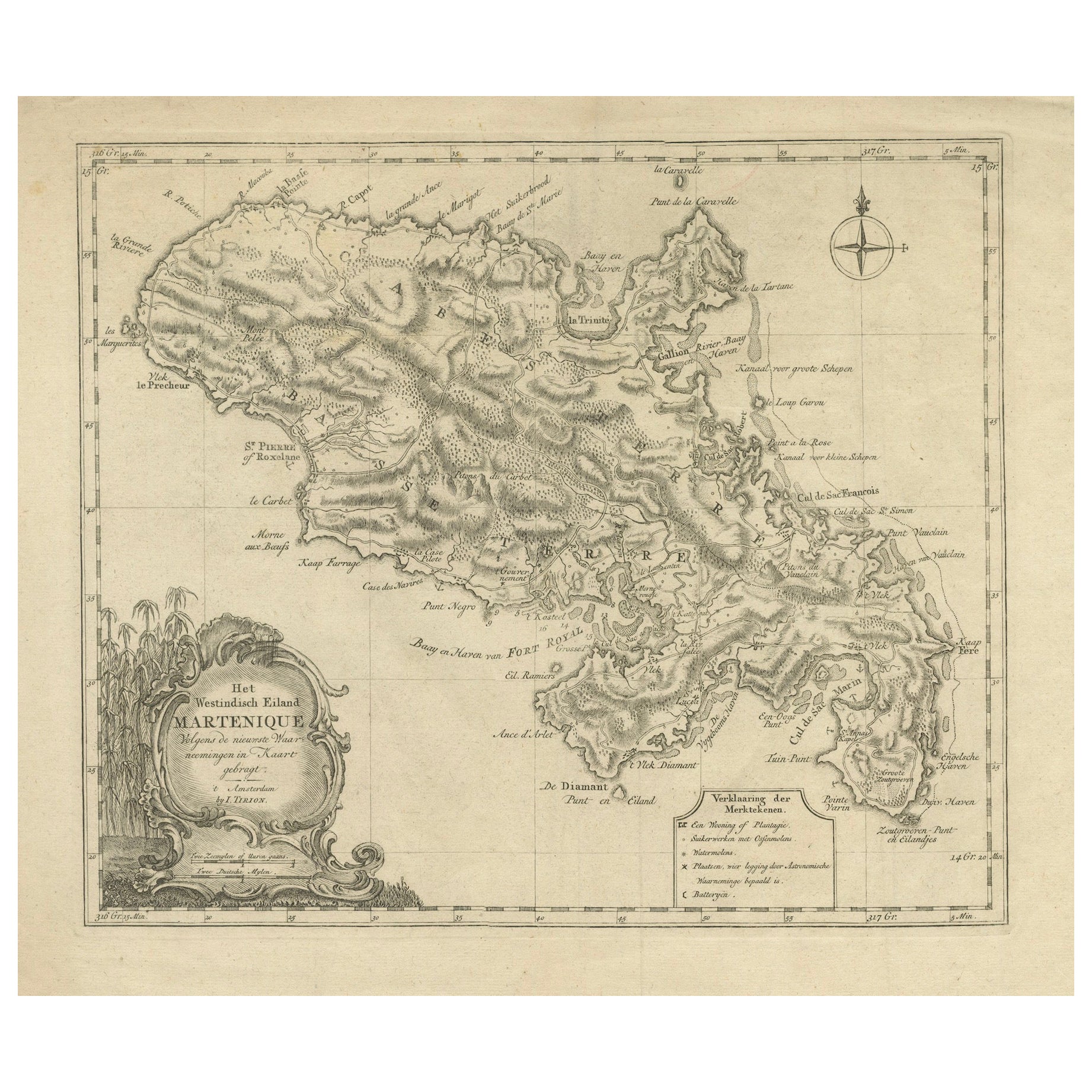
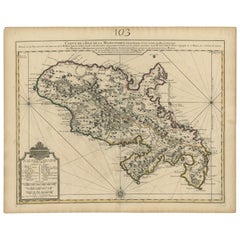
18th Century Original Dutch Map of Martinique in The West Indies by Isaak Tirion
Located in Langweer, NL
This is an 18th-century Dutch map of Martinique, titled *Het Westindisch Eiland Martinique*. The map was produced by Isaak Tirion, a renowned Dutch cartographer and publisher known for his precise and beautifully crafted maps. The cartouche in the lower left corner, adorned with decorative elements, adds to the aesthetic appeal of the map.
### Key Features:
- Martinique: The map offers detailed topographical information of the island, including mountains, rivers, and settlements.
- Geographical Details: Locations such as Fort Royal, Bay de St. Pierre, and Point de Cloche are marked, showcasing significant features of the island.
- Cartouche: The ornate cartouche, featuring tropical plants, reflects the importance of the island's agricultural production during the colonial period, particularly its sugar plantations.
This map captures Martinique during its time as a French colony and provides valuable insight into the island’s layout and strategic significance in the Caribbean. The attention to coastal detail highlights the importance of Martinique as a hub of maritime activity.
The map’s combination of aesthetic elegance and cartographic precision makes it a remarkable piece for collectors and those interested in Caribbean colonial...
Category
Antique 1760s Maps
Materials
Paper

$421 Sale Price
20% Off
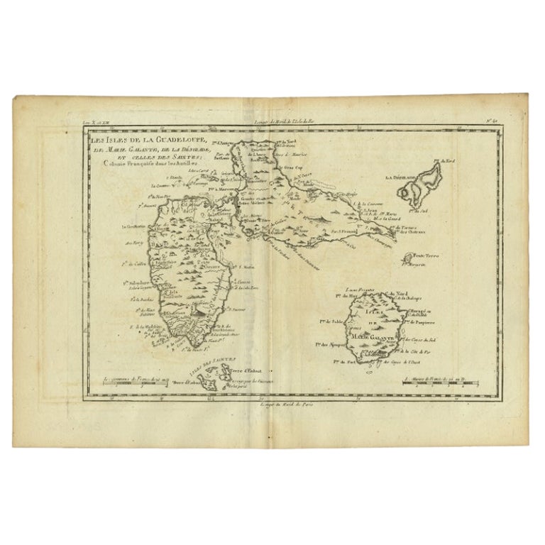
Antique Map of Guadeloupe with Les Saintes, Grand Bourg and La Désirade, c.1780
Located in Langweer, NL
Antique map titled 'Les Isles de la Guadeloupe (..).'
Map of the Caribbean Island of Guadeloupe with the surrounding islands Les Saintes, Grand Bourg and La Désirade. Source unknow...
Category
Antique 18th Century Maps
Materials
Paper
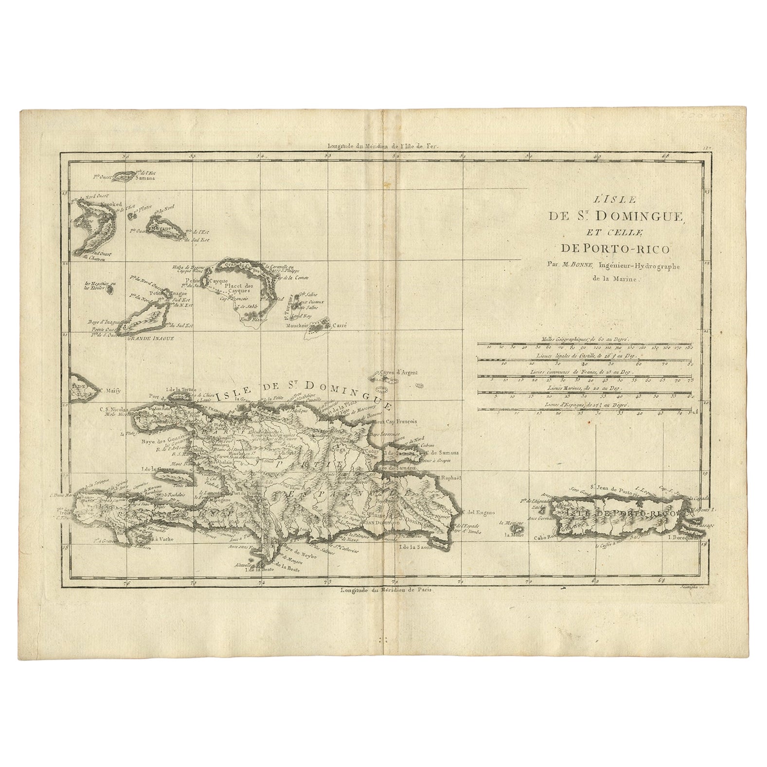
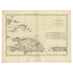
Detailed Antique Map of Santa Domingo, Puerto Rico, Eastern Bahamas, ca. 1780
Located in Langweer, NL
Description: Antique map titled 'L'Isle De St. Domingue, et celle De Porto-Rico.'
Detailed map of Santa Domingo, Puerto Rico, etc. Includes substanti...
Category
Antique 1780s Maps
Materials
Paper
Antique Map of Martinique, Showing Roads, Houses, Sugar Plantations, etc. c.1750
Located in Langweer, NL
Antique map titled 'Carte de l'Isle de la Martinique'.
Detailed map of Martinique. Shows hilly terrain, forests, roads, houses, and even the sugar plantations. The island was to ...
Category
Antique 18th Century Maps
Materials
Paper
You May Also Like
Map Colonies Francaises Martinique, 1845
Located in BUNGAY, SUFFOLK
Colonies Francaises, Martinique, Amerique DU SUD
Geographie et Statistique par V.Levasseur. Ing'r Geographe.
Illustre par Raymond Bonheur, peintre.
Grave par Laguihermie, Rue St...
Category
Antique 19th Century French Maps
Materials
Paper

Map Of The Island Of Cuba - Guillaume Thomas Raynal (1711-1796)
Located in Porto, PT
This historical map of the Island of Cuba was produced in the late 18th century and is taken from an edition of “Atlas de toutes les parties connues du globe terrestre” by the French...
Category
Antique 18th Century Prints
Materials
Glass, Paper

Map Of Martinique - Etching - 19th Century
Located in Roma, IT
Map Of Martinique is an etching realized by an anonymous engraver of the 19th Century.
Printed within the series "France Pittoresque" at the top center.
The state of preservation o...
Category
19th Century Modern Figurative Prints
Materials
Etching

Large Original Antique Map of The West Indies by Sidney Hall, 1847
Located in St Annes, Lancashire
Great map of The West Indies
Drawn and engraved by Sidney Hall
Steel engraving
Original colour outline
Published by A & C Black. 1847
Unframed
Free shipping.
Category
Antique 1840s Scottish Maps
Materials
Paper

Early 19th Century Hand Colored Map of the United States and Caribbean Islands
Located in Hamilton, Ontario
Hand coloured early 19th century map by Giraldon of France titled "Etats Unis et Grandes Antilles" (United States and Greater Antilles).
Category
Antique Early 19th Century French Maps
Materials
Paper

$595 Sale Price
40% Off
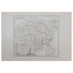
1762 Berri, Nivernois Bourbonois, Lyonois, Bourgogine, Bresse, et, Franche - Com
Located in Norton, MA
1762 Vaugondy map, entitled
"Berrl Nivernois Bourbonois Lyonois, Bourgone, Bresse, Et Franche-Comte,"
Ric.b003
About this Item
A fine Copperplate Engraving with original han...
Category
Antique 18th Century Unknown Maps
Materials
Paper
More Ways To Browse
French Campaign
Furniture From 1790
18th Century Engravings
Antique Carved Wood Chair
Black Scandinavian Modern Dining Chairs
Dutch Mid Century Modern Table
Gold Modern Coffee Table
Iconic Modern Furniture
Midcentury Modern Gray Glass Vase
Round Glass Coffee Tables
Vintage Cave
18th Century Wood Side Tables
Antique Hand Carved Dining Room Sets
Mid Century Modern Pitcher
Vintage Italian Leather Dining Chair
Vintage Movie Posters
Blue Green Wool And Silk Rug
Brown Sheepskin Chair