Items Similar to Small Early 18th Century Map of Banten Bay on the Island Java, Indonesia, c.1725


Want more images or videos?
Request additional images or videos from the seller
1 of 5
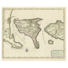
Small Early 18th Century Map of Banten Bay on the Island Java, Indonesia, c.1725
$212.31
$265.3920% Off
£155.58
£194.4820% Off
€176
€22020% Off
CA$291.38
CA$364.2320% Off
A$307.87
A$384.8420% Off
CHF 165.60
CHF 20720% Off
MX$3,686.27
MX$4,607.8420% Off
NOK 2,074.76
NOK 2,593.4520% Off
SEK 1,900.18
SEK 2,375.2320% Off
DKK 1,340.52
DKK 1,675.6420% Off
About the Item
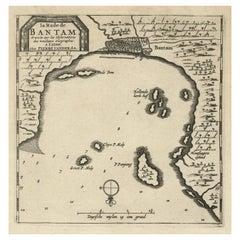
A small early 18th century map of Banten Bay showing the islands of Pulo Dua and Pulo Batto together with soundings within the Bay and profiles of hills on the islands published by Constantin de Renneville (c. 1650-1723) in his Recueil des voyages qui ont servi a l’establissment et aux progre de la Compagnie des Indes Orientales in Amsterdam in 1703. De Renneville’s publication was a translation and adaption of Isaak Commelin’s Begin ende voortgangh van de vereenighde Nederlandtsche Geoctroyeende Oost-Indische Compagnie thought to have been first published in Amsterdam around 1645.
Artists and Engravers: Author: Constantin de Renneville (ca. 1650-1723).
Condition: Good, given age. Original folds as issued. General age-related toning and/or occasional minor defects from handling. Please study scan carefully.
- Dimensions:Height: 6.3 in (16 cm)Width: 8.59 in (21.8 cm)Depth: 0 in (0.02 mm)
- Materials and Techniques:
- Period:1720-1729
- Date of Manufacture:circa 1725
- Condition:Wear consistent with age and use.
- Seller Location:Langweer, NL
- Reference Number:Seller: BL-000691stDibs: LU3054326824672
About the Seller
5.0
Recognized Seller
These prestigious sellers are industry leaders and represent the highest echelon for item quality and design.
Platinum Seller
Premium sellers with a 4.7+ rating and 24-hour response times
Established in 2009
1stDibs seller since 2017
2,848 sales on 1stDibs
Typical response time: 1 hour
- ShippingRetrieving quote...Shipping from: Langweer, Netherlands
- Return Policy
More From This Seller
View AllAntique Map of Banten Bay, Java, Indonesia, c.1725
Located in Langweer, NL
A small early 18th century map of Banten Bay showing the islands of Pulo Dua and Pulo Batto together with soundings within the Bay and profiles of hills on the islands published by C...
Category
Antique 18th Century Maps
Materials
Paper

Antique Map of Banten Bay on Java Island, Indonesia, c.1720
Located in Langweer, NL
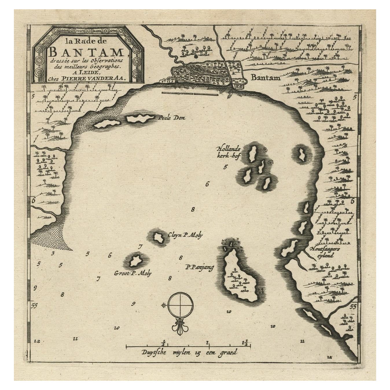
Antique map titled 'La Rade de Bantam'. A small early 18th century black and white map of Banten Bay (or Bantam Bay), located near the northwest co...
Category
Antique 18th Century Maps
Materials
Paper
Antique Map of Java and Madura Island, Indonesia, c.1760
Located in Langweer, NL
Antique map titled 'Idee de l'Isle de Java.'
Well engraved and attractive chart of the island shows all principal harbors and coastal details, plus rivers, mountains and volcanoe...
Category
Antique 18th Century Maps
Materials
Paper

Antique Map of the Bay of Bantam, c.1720
Located in Langweer, NL
Rare, untitled miniature map of the Bay of Bantam with various Islands including Pulo Dua and Pulo Batto. This map originates from a small travelogue and may originate from an editio...
Category
Antique 18th Century Maps
Materials
Paper

$57 Sale Price
20% Off
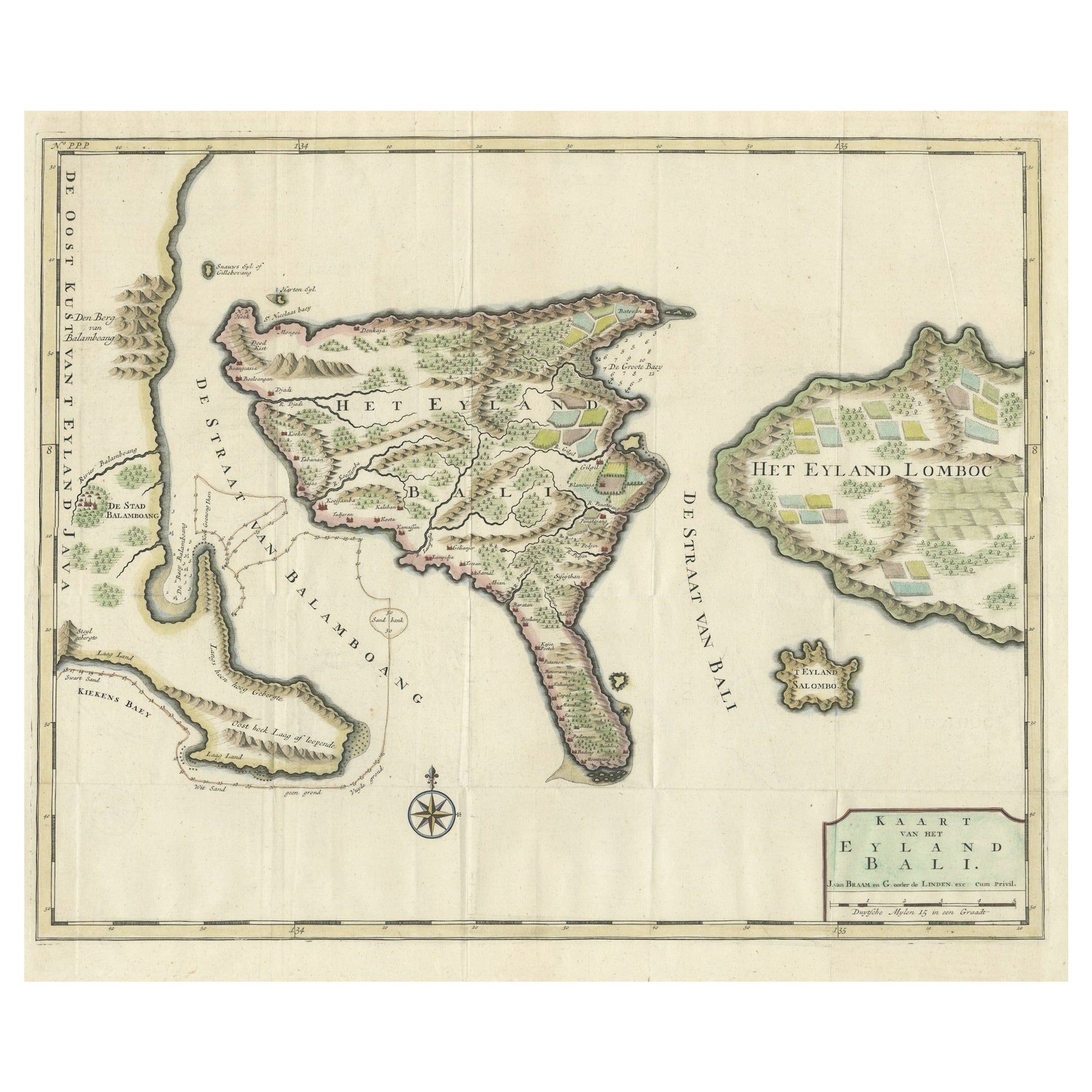
1726 Valentyn
s Map of Bali and Lombok, Original Engraving
Located in Langweer, NL
This antique map is a detailed 18th-century chart of the island of Bali, one of the many islands of Indonesia, with an inset of the neighboring island Lombok, attributed to François ...
Category
Antique Early 18th Century Dutch Maps
Materials
Paper
$1,447 Sale Price
20% Off
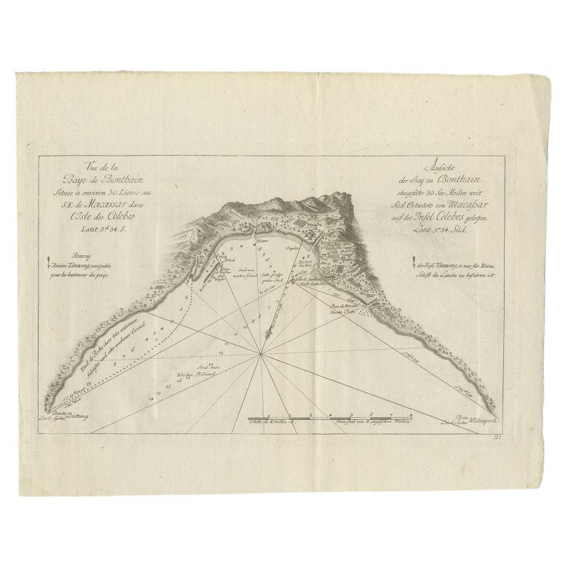
Antique Map of a Bay Nearby Makassar, Celebes
Sulawesi)
by Hawkesworth, 1774
Located in Langweer, NL
Antique map titled 'Vue de la Baye de Bonthain (..)'. Map of the island Sulawesi (Celebes), Indonesia that Philip Carteret rested his crew and made repairs to his ship the Swallow fo...
Category
Antique 18th Century Maps
Materials
Paper
You May Also Like
Antique Voc Print Holland Malaysia Old Map Melaka History, 1663
Located in Amsterdam, Noord Holland
From my own collection I offer this impressive Antique print of the city of Malakka
A very interesting piece for collectors . It is an museum piece from the Dutch Institute of Orien...
Category
Antique 17th Century European Paintings
Materials
Paper

$293 Sale Price
20% Off
West Coast of Africa, Guinea
Sierra Leone: An 18th Century Map by Bellin
By Jacques-Nicolas Bellin
Located in Alamo, CA
Jacques Bellin's copper-plate map entitled "Partie de la Coste de Guinee Dupuis la Riviere de Sierra Leona Jusquau Cap das Palmas", depicting the coast of Guinea and Sierra Leone in ...
Category
Antique Mid-18th Century French Maps
Materials
Paper

Ancient Map - Zeilan - Etching by Johannes Janssonius - 1650s
By Johannes Janssonius
Located in Roma, IT
Ancient Map - Zeilan is an ancient map realized in 1650 by Johannes Janssonius (1588-1664).
The Map is Hand-colored etching, with coeval watercoloring.
...
Category
1650s Modern Figurative Prints
Materials
Etching

Rugen Island, Germany: An Early 17th Century Map by Mercator and Hondius
By Gerard Mercator
Located in Alamo, CA
This is an early 17th century map entitled "Nova Famigerabilis Insulae Ac Ducatus Rugiae Desciptio" (Map of Rugen Island, Germany) by Gerard Mercator and Henricus and Joducus Hondiu...
Category
Early 17th Century Old Masters Landscape Prints
Materials
Engraving

1627 Hendrik Hondius Map Entitled "Vltoniae Orientalis Pars, " Ric.a009
Located in Norton, MA
1627 Hendrik Hondius map entitled
"Vltoniae orientalis pars,"
Ric.a009
Title:
Vltoniae orientalis : pars
Title (alt.) :
Ultoniae orientalis pars
Creator:
Mercator, Gerh...
Category
Antique 17th Century Dutch Maps
Materials
Paper

Antique French Map of Asia Including China Indoneseia India, 1783
Located in Amsterdam, Noord Holland
Very nice map of Asia. 1783 Dedie au Roy.
Additional information:
Country of Manufacturing: Europe
Period: 18th century Qing (1661 - 1912)
Condition: Overall Condition B (Good Used)...
Category
Antique 18th Century European Maps
Materials
Paper

$486 Sale Price
40% Off
More Ways To Browse
Compagnie Des Indes
Australian Colonial
Bengal Map
Stanford Furniture
Tennessee Antique Furniture
Used Furniture Alabama
Used Office Furniture Maine
Ancient World Map
Antique Florida Map
Antique Map Chile
Antique Map Of Georgia
Antique Mississippi Furniture
Burgundy Map
John Speed Antique Maps
Malabar Map
Malaysia Map
Map Of Syria
Taiwan Map