Items Similar to Small Original Antique Map of Switzerland and Surroundings, 1807


Want more images or videos?
Request additional images or videos from the seller
1 of 5
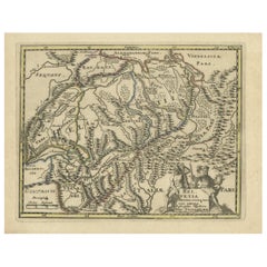
Small Original Antique Map of Switzerland and Surroundings, 1807
$124.39
$155.4920% Off
£92.37
£115.4620% Off
€104
€13020% Off
CA$170.89
CA$213.6220% Off
A$185.80
A$232.2420% Off
CHF 98.51
CHF 123.1420% Off
MX$2,227.22
MX$2,784.0220% Off
NOK 1,252
NOK 1,56520% Off
SEK 1,147
SEK 1,433.7520% Off
DKK 792.81
DKK 991.0220% Off
About the Item
Antique map titled 'Switzerland with its subjects
allies from the best authorities'.
Small map of Switzerland and surroundings. Originates from 'A general view of the world' by Blomfield.
Artists and engravers: Engraved by J. Barlow. Published by C. Brightly and E. Kinnersly.
- Dimensions:Height: 8.08 in (20.5 cm)Width: 10.24 in (26 cm)Depth: 0 in (0.02 mm)
- Materials and Techniques:
- Period:
- Date of Manufacture:1807
- Condition:Wear consistent with age and use. Condition: Very good, general age-related toning. Original, contemporary hand coloring. Please study image carefully.
- Seller Location:Langweer, NL
- Reference Number:Seller: BG-09350 1stDibs: LU3054327093292
About the Seller
5.0
Recognized Seller
These prestigious sellers are industry leaders and represent the highest echelon for item quality and design.
Platinum Seller
Premium sellers with a 4.7+ rating and 24-hour response times
Established in 2009
1stDibs seller since 2017
2,823 sales on 1stDibs
Typical response time: 1 hour
- ShippingRetrieving quote...Shipping from: Langweer, Netherlands
- Return Policy
More From This Seller
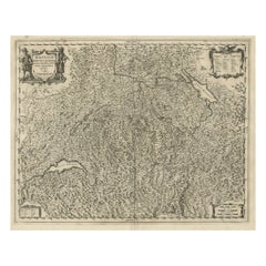
View AllAntique Map of Switzerland by Keizer
de Lat, 1788
Located in Langweer, NL
Antique map titled 'La Suisse (..)'. Uncommon original antique map of Switzerland. This map originates from 'Nieuwe Natuur- Geschied- en Handelkundige Zak- en Reisatlas' by Gerrit Br...
Category
Antique Late 18th Century Maps
Materials
Paper

$334 Sale Price
20% Off
Antique Map of Switzerland by J.B. Homann, 1751
By Johann Baptist Homann
Located in Langweer, NL
Decorative example of Homann's map of Switzerland, with decorative cartouche and the coat of arms of each of the 13 Cantons.
Category
Antique Mid-18th Century Maps
Materials
Paper

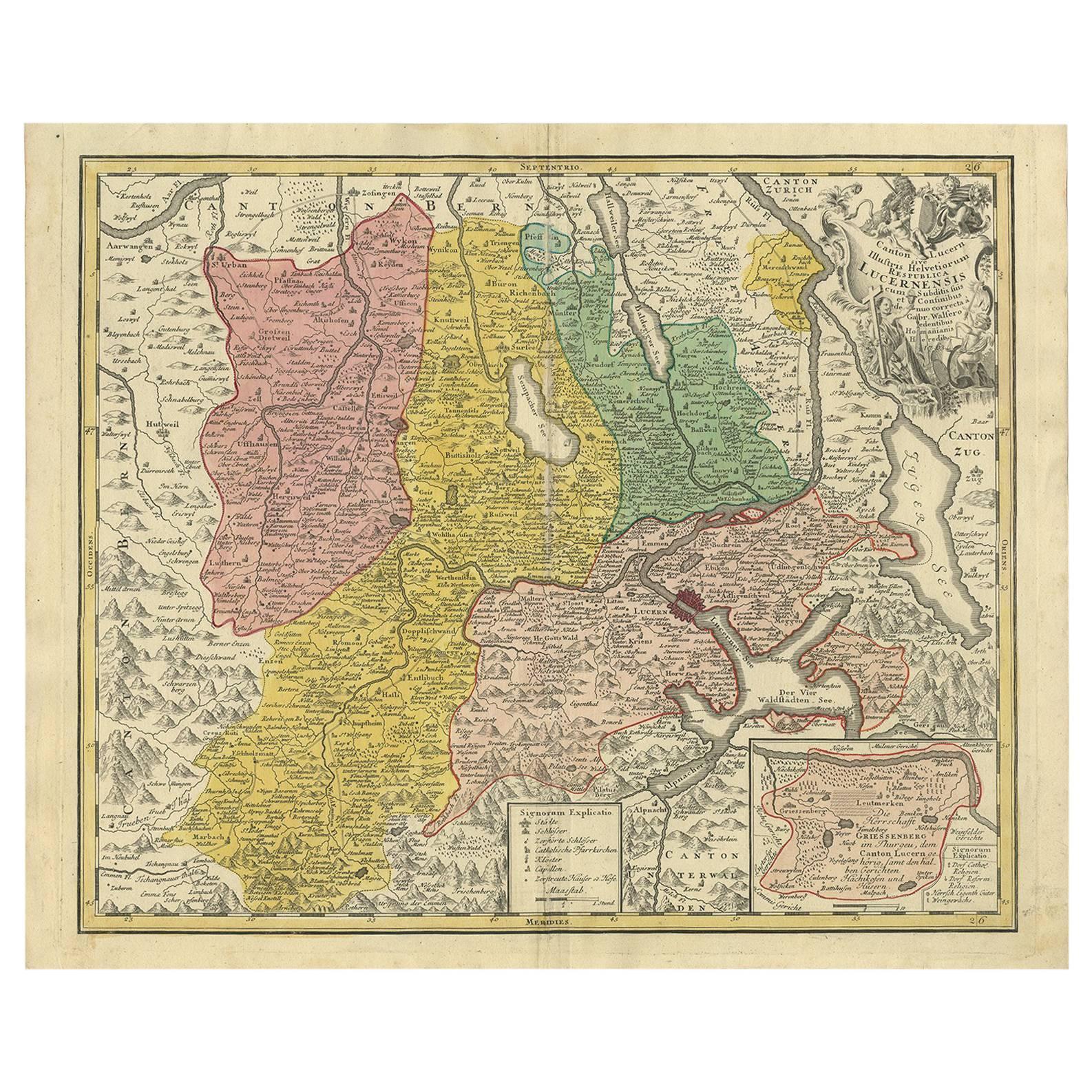
Antique Map of the Kanton Luzerne
Switzerland
by Homann Heirs, 1763
Located in Langweer, NL
Antique map titled 'Canton Lucern (..)'. Fine decorative copper plate engraved antique map of the Canton of Lucerne in Central Switzerland with pictorial cartouche in top right corne...
Category
Antique Mid-18th Century Maps
Materials
Paper
Genuine Antique Engraved Map of Helvetia or Switzerland, 1729
Located in Langweer, NL
Decorative early 18th century engraved map of Switzerland.
Title: Helvetia Conterminarumq terra rum antiqua.
Translated from Latin: Switzerland is an ancient land
Description: Switzerland, antique copperplate engraved map with hand coloring and a decorative title cartouche. Two figures greatly enhances visual appeal.
Author: Phillip Cluver, or Philip Cluverius, Philipp Clüver, Latinized as Philippus Cluverius studied law in Leiden and settled over there in 1615.
We only sell Guaranteed Absolutely Original authentic Maps and Prints.
A Certificate of Authenticity ( COA ) will be supplied on request.
We ship our antique maps and prints...
Category
Antique 1720s Maps
Materials
Paper
$373 Sale Price
20% Off
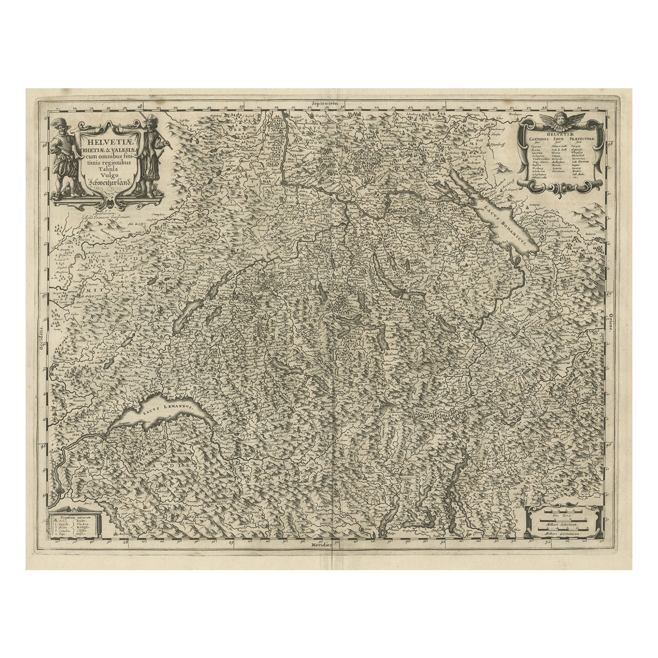
Decorative and Detailed Original Antique Map of Switzerland, 1657
Located in Langweer, NL
Antique map of Switzerland titled 'Helvetiae Rhetiae & Valesiae'.
Decorative and detailed map of Switzerland. This map originates from 'Atlas Novus, Sive Theatrum Orbis Orbis Ter...
Category
Antique 1650s Maps
Materials
Paper
Antique Map of Northern Switzerland by Janssonius
1657
By Johannes Janssonius
Located in Langweer, NL
Antique map 'Zurichgow et Basiliensis provincia'. Detailed map of northern Switzerland, including Zurich and Basel. This map originates from 'Atlas Novus, Sive Theatrum Orbis Orbis T...
Category
Antique Mid-17th Century Maps
Materials
Paper

You May Also Like
Map of Switzerland - Etching - 19th Century
Located in Roma, IT
This map of Netherlands is an etching realized in 19th century.
The state of preservation of the artwork is excellent. The signature "F.B." is engraved on the lower right. At the to...
Category
19th Century Figurative Prints
Materials
Etching

1839 Map of Karte Des "Russischen Reiches in Europa Und Asien" Ric.R0013
Located in Norton, MA
1839 map of Karte Des
"Russischen Reiches in Europa and Asien"
Ric.r013
Map of the European and Asian parts of Russian Empire. Karte der Russischen Reiches in Europa und Asien...
Category
Antique 19th Century Unknown Maps
Materials
Paper

1790 Thomas Stackhouse Map, Entitled "Russia in Europe, " , Ric.a004
Located in Norton, MA
1790 Thomas Stackhouse map, entitled
"Russia in Europe"
Ric.a004
Stackhouse, Thomas
Russia in Europe [map]
London: T. Stackhouse, 1783. Map. Matted hand-colored copper engraving. Image size: 14.5 x 15.25 inches. Mat size: 22.75 x 23.75 inches. A beautiful example of this map of Eastern Europe...
Category
Antique 17th Century Unknown Maps
Materials
Paper

Original Antique Map of Hungary, Arrowsmith, 1820
Located in St Annes, Lancashire
Great map of Hungary
Drawn under the direction of Arrowsmith.
Copper-plate engraving.
Published by Longman, Hurst, Rees, Orme and Brown, 1820
Unframed.
Category
Antique 1820s English Maps
Materials
Paper

Original Antique Map of Europe, Arrowsmith, 1820
Located in St Annes, Lancashire
Great map of Europe
Drawn under the direction of Arrowsmith.
Copper-plate engraving.
Published by Longman, Hurst, Rees, Orme and Brown, 1820
...
Category
Antique 1820s English Maps
Materials
Paper

Antique French Map of Asia Including China Indoneseia India, 1783
Located in Amsterdam, Noord Holland
Very nice map of Asia. 1783 Dedie au Roy.
Additional information:
Country of Manufacturing: Europe
Period: 18th century Qing (1661 - 1912)
Condition: Overall Condition B (Good Used)...
Category
Antique 18th Century European Maps
Materials
Paper

$486 Sale Price
40% Off
More Ways To Browse
Taiwan Map
Antique Chicago Maps
Dutch Bible
New Jersey 19th Century
Thailand Map
Antique Coal Mining
Antique Dutch Bible
Antique Louisiana Map
Antique Maps Of Sicily
Iran Map
Map Of Great Britain
Sardinia Map
Antique Map Of Thailand
Antique Wooden Roller
Croatia Map
Kentucky Antique Furniture
Louisiana Antique Furniture
Map Of Ancient Greece