Items Similar to The Solar System – Astronomical Lithograph - The Nieuwe Hand-Atlas, Leiden 1876
Want more images or videos?
Request additional images or videos from the seller
1 of 10
The Solar System – Astronomical Lithograph - The Nieuwe Hand-Atlas, Leiden 1876
$406.47
£303.36
€340
CA$560.69
A$613.30
CHF 322.92
MX$7,322.22
NOK 4,115.67
SEK 3,764.86
DKK 2,590.24
About the Item
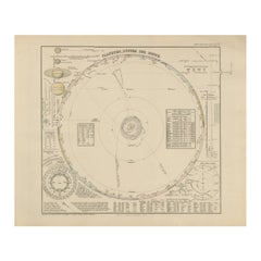
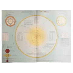
The Solar System – Astronomical Lithograph from the Nieuwe Hand-Atlas, Leiden 1876
This detailed 19th-century Dutch astronomical lithograph, titled “Het Planeten-Stelsel” (The Planetary System), was published in 1876 as part of the “Nieuwe Hand-Atlas der Aarde in haren Tegenwoordigen Toestand” by M. Frijlink, revised and expanded by A. van Otterloo, and issued by D. Noothoven van Goor in Leiden. The print offers a complete visual overview of the solar system according to 19th-century astronomical knowledge, beautifully combining scientific clarity with elegant design.
The large central diagram presents a heliocentric view of the planetary orbits around the Sun, from Mercury to Neptune, including the asteroid belt (labeled Planetoïden). Around it are multiple smaller inset diagrams that illustrate important astronomical concepts. These include comparative charts of planetary sizes and distances, the phases of the Moon, the relative size of the solar disk, the tilt of the Earth’s axis, and the orbital mechanics that explain the change of seasons. At upper left are the orbits and appearances of Saturn and Jupiter with their characteristic rings and bands, while at lower left appears a map of key northern constellations (Eenige der voornaamste Sterrebeelden). The entire composition is filled with fine scientific annotations in Dutch, numerical data tables, and precise geometric constructions.
This plate served as an educational introduction to the structure of the universe within the context of Frijlink’s Hand-Atlas, which was a standard geographic and scientific reference in Dutch schools during the late 19th century. The atlas was admired for its combination of accessible explanation and visual elegance, produced by leading Dutch cartographers and engravers of the period.
Condition report:
Good condition for age. Light overall toning and minor foxing in the margins, consistent with age. The plate mark is visible around the printed area, and the impression remains crisp and clear. Minor handling signs near the edges but no tears or losses.
Framing tips:
This lithograph would look elegant when mounted on a soft beige or warm ivory mat with a thin black inner line and displayed in a dark wooden or black frame. The subtle tones and delicate linework suit both classical and modern interiors, especially in libraries, studies, or educational spaces.
Technique: Lithograph
Maker: A. van Oort after M. Frijlink, Leiden, 1876
- Dimensions:Height: 17.33 in (44 cm)Width: 21.66 in (55 cm)Depth: 0.01 in (0.2 mm)
- Materials and Techniques:
- Place of Origin:
- Period:
- Date of Manufacture:1876
- Condition:Good condition for age. Light overall toning and minor foxing in the margins, consistent with age. The plate mark is visible around the printed area, and the impression remains crisp and clear. Minor handling signs near the edges but no tears or loss.
- Seller Location:Langweer, NL
- Reference Number:Seller: BG-12788-11stDibs: LU3054347449652
About the Seller
5.0
Recognized Seller
These prestigious sellers are industry leaders and represent the highest echelon for item quality and design.
Platinum Seller
Premium sellers with a 4.7+ rating and 24-hour response times
Established in 2009
1stDibs seller since 2017
2,809 sales on 1stDibs
Typical response time: 1 hour
- ShippingRetrieving quote...Shipping from: Langweer, Netherlands
- Return Policy
More From This Seller
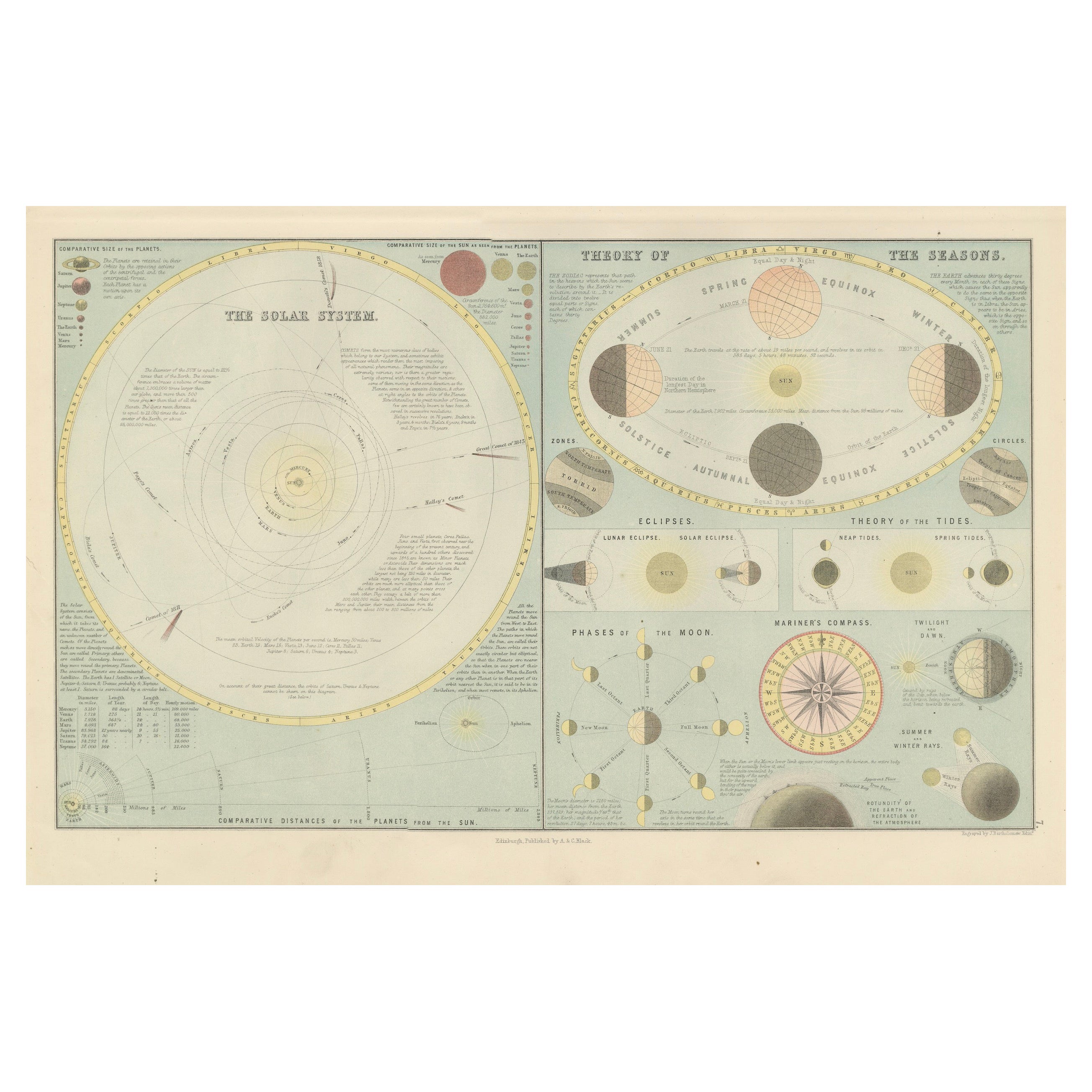
View AllAntique Astronomical Chart of the Solar System and Seasons – Black’s Atlas, 1884
Located in Langweer, NL
Antique Astronomical Chart of the Solar System and Seasons – Black’s Atlas, 1884
This striking scientific chart comes from the New and Revised Edition of Black’s General Atlas of th...
Category
Antique 1880s Scottish Maps
Materials
Paper
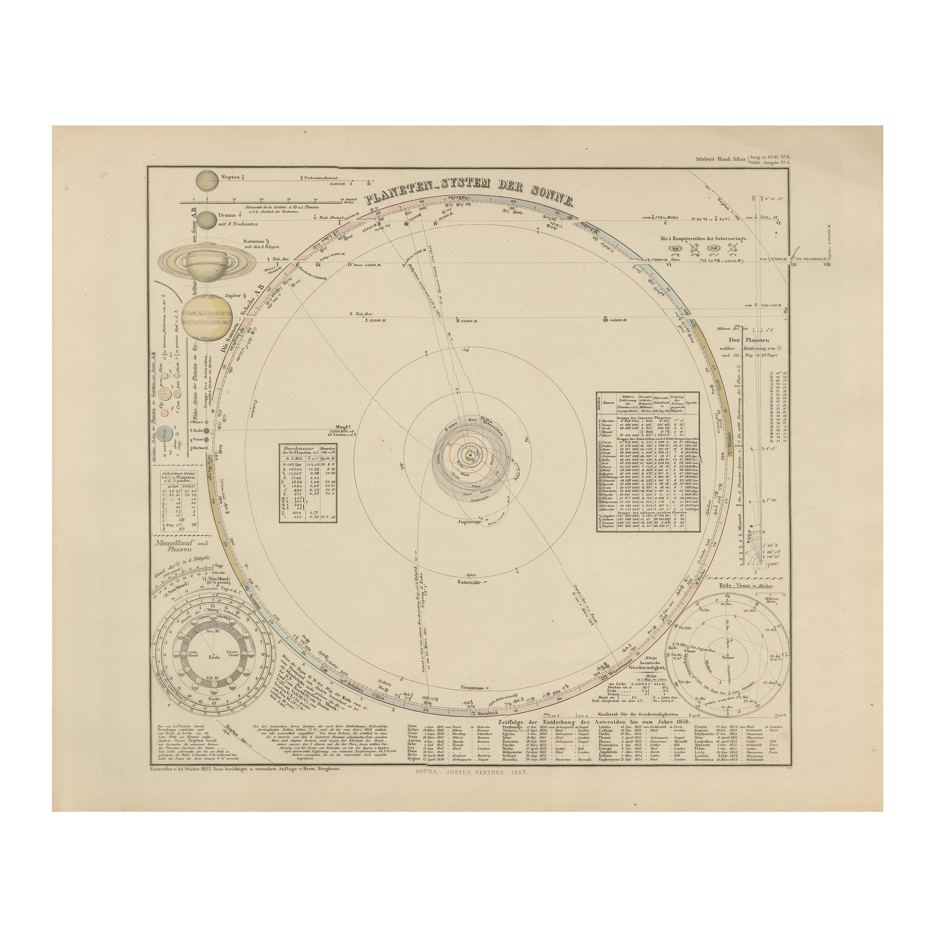
Solar System Map – Planetary Orbits and Data Chart, Published in 1857
Located in Langweer, NL
Solar System Map – Planetary Orbits and Data Chart 1857
This antique print shows a detailed diagram of the solar system titled “Planeten-System der Sonne” meaning “Planetary System ...
Category
Antique Mid-19th Century German Maps
Materials
Paper
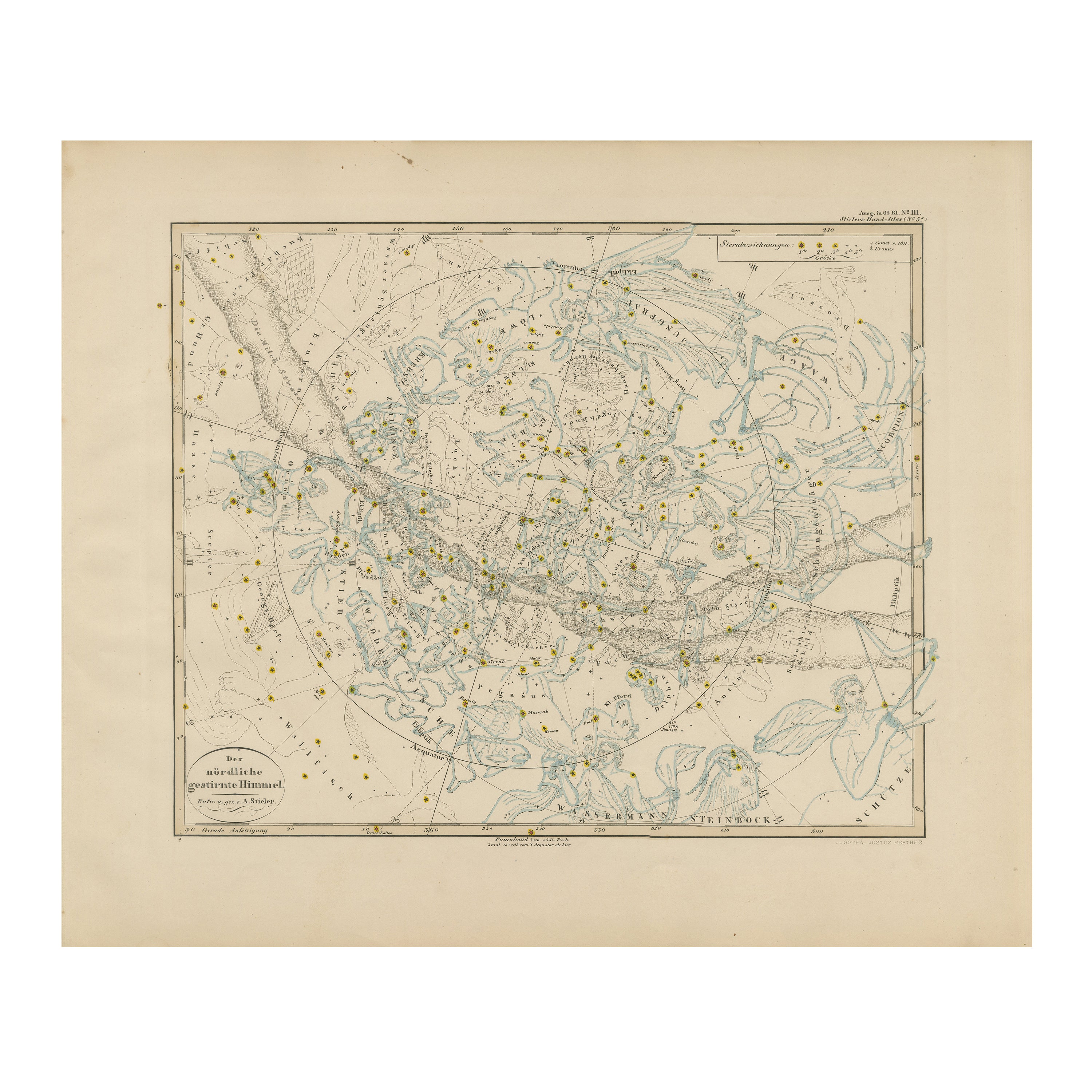
Northern Hemisphere Star Map – Constellations
Astronomical Chart, c.1858
Located in Langweer, NL
Northern Hemisphere Star Map – Constellations & Astronomical Chart c.1858
This attractive antique print shows the northern starry sky titled “Der nördliche gestirnte Himmel”, meanin...
Category
Antique Mid-19th Century German Maps
Materials
Paper
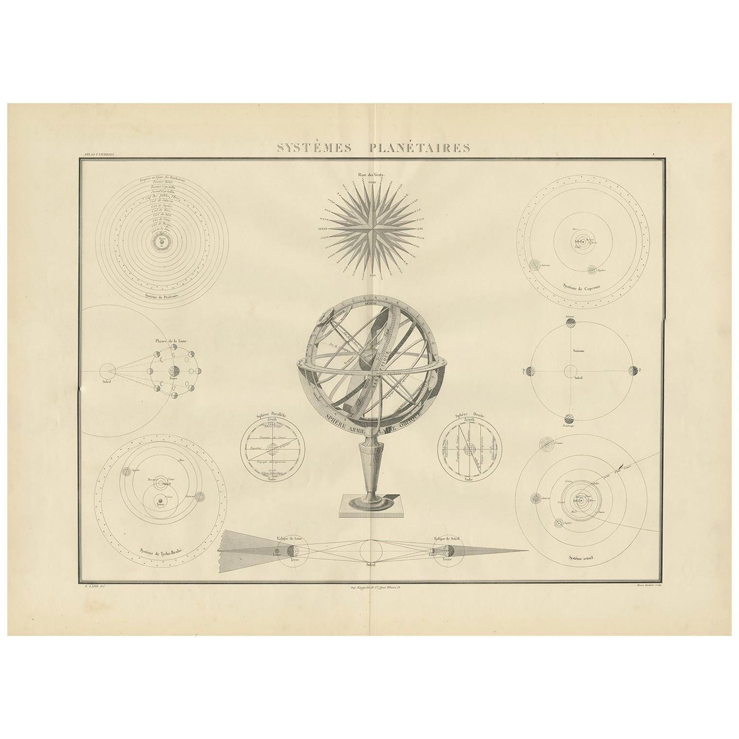
Antique Chart of Celestial and Scientific Models by Lapie, 1842
Located in Langweer, NL
Antique print titled 'Systèmes Planétaires'. Chart of various celestial and scientific models. Includes an armillary sphere and various models of the universe, the season, eclipses, a Copernican, Tycho...
Category
Antique Mid-19th Century French Prints
Materials
Paper
$717 Sale Price
25% Off
Antique Celestial Star Map – Northern
Southern Hemispheres, 1860
Located in Langweer, NL
Antique Celestial Star Map – Northern & Southern Hemispheres, Andriveau-Goujon 1860
This elegant antique celestial chart, published in Paris in 1860 by the noted French cartographer...
Category
Antique Mid-19th Century French Maps
Materials
Paper
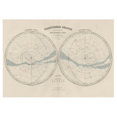
Antique Map of the Night Skies of the Northern and Southern Hemispheres, 1880
Located in Langweer, NL
Antique world map titled 'Planisphère en Céleste'.
This map depicts the night skies of both the northern and southern hemispheres. This map originates from 'Géographie Universell...
Category
Antique 1880s Maps
Materials
Paper
$277 Sale Price
20% Off
You May Also Like
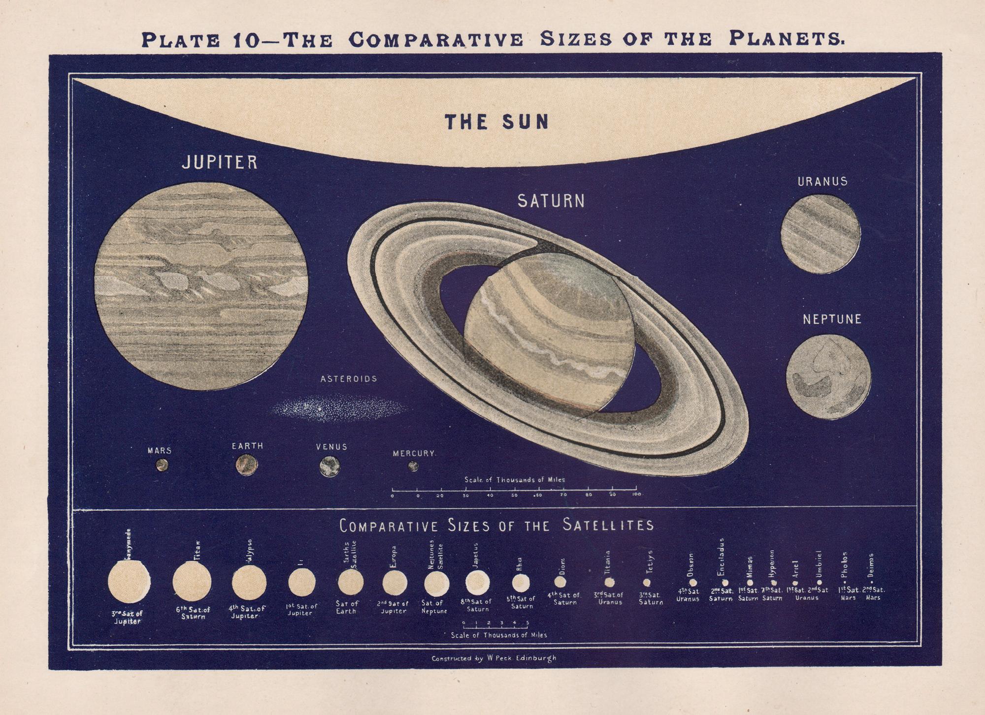
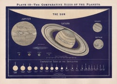
The Comparative Sizes of the Planets. Antique Astronomy diagram
Located in Melbourne, Victoria
Colour lithograph, 1890. 210mm by 285mm (sheet). From W Peck's 'A Handbook and Atlas of Astronomy', 1890. Sir William Peck FRSE FRAS (1862 – 1925) was a Scottish astronomer and scien...
Category
Late 19th Century Victorian More Prints
Materials
Lithograph
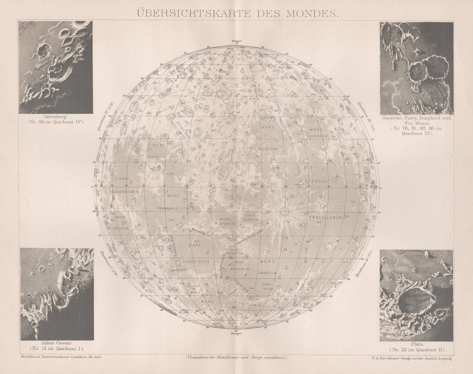
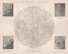
Ubersichtskarte Des Mondes (Overview Map of the Moon), antique astronomy print
Located in Melbourne, Victoria
'Ubersichtskarte Des Mondes'
(Overview Map of the Moon)
German chromolithograph, circa 1895.
245mm by 305mm (sheet).
Central vertical fold as issued.
Category
Late 19th Century Naturalistic Still-life Prints
Materials
Lithograph
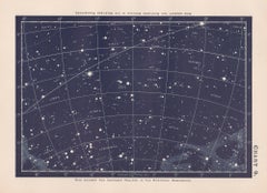
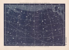
Star Chart. Antique Astronomy celestial print
Located in Melbourne, Victoria
Colour lithograph, 1890. 210mm by 285mm (sheet). From W Peck's 'A Handbook and Atlas of Astronomy', 1890. Sir William Peck FRSE FRAS (1862 – 1925) was a Scottish astronomer and scien...
Category
Late 19th Century Victorian More Prints
Materials
Lithograph
Original Antique Astronomy Print. C.1900
Located in St Annes, Lancashire
Great image of the solar system
Unframed.
Chromo-lithograph
Published, C.1900
The measurement is the paper size of the print
Free shipping.
Category
Antique Early 1900s English Folk Art Prints
Materials
Paper
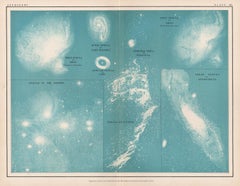
Nebulae, antique astronomy science diagram illustration print
Located in Melbourne, Victoria
Nebulae.
Antique lithograph by W & AK Johnston, famous Scottish cartographers.
Central vertical fold as issued. From Thomas Heath's 'The Twentieth Centur...
Category
Early 20th Century Victorian More Prints
Materials
Lithograph