Items Similar to Stunning Hand-Colored Map of Languedoc in France by Frederik De Wit c. 1688


Want more images or videos?
Request additional images or videos from the seller
1 of 6
Stunning Hand-Colored Map of Languedoc in France by Frederik De Wit c. 1688
$759.04
£570.49
€640
CA$1,051.66
A$1,143.11
CHF 611.93
MX$13,817.56
NOK 7,711.46
SEK 7,111.97
DKK 4,875.37
About the Item
Title: Stunning Hand-Colored Map of Languedoc by Frederik De Wit c. 1688
Description: This elegant 17th-century map, "Gouvernement General de Languedoc," beautifully illustrates the Languedoc region in southern France. Created by Frederik De Wit and published around 1688, the map features original hand-coloring and exquisite detailing of towns, rivers, mountains, and coastal features along the Mediterranean Sea. The ornate cartouche in the top left corner, adorned with the region’s coat of arms and symbolic embellishments, adds a touch of artistry to this cartographic masterpiece.
De Wit’s map also includes a compass rose and a charming depiction of a sailing ship in the Mediterranean, emphasizing the region's historical maritime importance. This piece was part of De Wit’s renowned composite atlases, which combined maps from his own work and those of other esteemed Amsterdam mapmakers such as Hondius and Blaeu. These atlases were highly prized for their blend of geographic precision and decorative appeal, making them a staple for collectors of the era.
Frederik De Wit was a prominent figure in the golden age of Dutch cartography, celebrated for his town plans and atlases. His works remain sought after today for their historical significance and visual splendor.
Condition Report: The map is in very good condition with vibrant hand-coloring. Minor age-related imperfections, such as faint toning or small foxing spots, are present, due to age and handling. Please examine the image for specific details.
Framing and Matting Tips: This map’s decorative cartouche and Mediterranean coastal elements are perfect for display in a sophisticated frame. Opt for a dark wood or gilded frame to complement the map's rich colors. Acid-free matting in a neutral tone will protect and enhance its presentation. For added preservation, use UV-protective glass to maintain the vibrancy of the original hand-coloring. Display it in a study, library, or living room for a timeless and elegant touch.
- Dimensions:Height: 20.83 in (52.9 cm)Width: 24.41 in (62 cm)Depth: 0.01 in (0.2 mm)
- Materials and Techniques:Paper,Engraved
- Period:1680-1689
- Date of Manufacture:circa 1688
- Condition:Condition Report: The engraving is in good to very good condition, with some offsetting or color bleeding visible. Minor age-related imperfections. Centrefold as issued. Please examine the image carefully for additional details.
- Seller Location:Langweer, NL
- Reference Number:Seller: BG-14046-41stDibs: LU3054343438992
About the Seller
5.0
Recognized Seller
These prestigious sellers are industry leaders and represent the highest echelon for item quality and design.
Platinum Seller
Premium sellers with a 4.7+ rating and 24-hour response times
Established in 2009
1stDibs seller since 2017
2,777 sales on 1stDibs
Typical response time: <1 hour
- ShippingRetrieving quote...Shipping from: Langweer, Netherlands
- Return Policy
More From This Seller
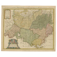
View AllProvence – Antique Hand-Coloured Map of Southern France Region, c.1740
Located in Langweer, NL
Le Comté et Gouvernement de Provence – Antique Hand-Coloured Map by De l’Isle & Homann Heirs (c.1740)
This finely hand-coloured 18th-century map presents the County and Government o...
Category
Antique 1740s German Maps
Materials
Paper
Rare Hand-Colored Map of Lorraine and Barrois, France by Frederik De Wit c. 1688
Located in Langweer, NL
Title: Rare Hand-Colored Map of Lorraine and Barrois by Frederik De Wit c. 1688
Description: This remarkable 17th-century map, titled "Generalis Lotharingiae Ducatus," offers a deta...
Category
Antique 1680s Maps
Materials
Paper

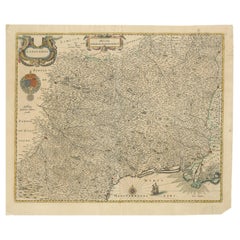
Rare Hand-Colored Map of Lyonnais Region in France by Frederik De Wit c. 1688
Located in Langweer, NL
Title: Rare Hand-Colored Map of Lyonnais Region by Frederik De Wit c. 1688
Description: This beautifully detailed map, "Gouvernement General du Lyonnois," showcases the Lyonnais reg...
Category
Antique 1680s Maps
Materials
Paper

Rare Hand-Colored Map of Franche-Comté and Burgundy by Frederik De Wit c. 1688
Located in Langweer, NL
Title: Rare Hand-Colored Map of Franche-Comté and Burgundy by Frederik De Wit c. 1688
Description: This stunning 17th-century map, titled "Comitatus Burgundiae vulgo La Franche Comt...
Category
Antique 1680s Maps
Materials
Paper
Hand-Colored 17th-Century Map of Orléanais in France by Frederik De Wit c. 1688
Located in Langweer, NL
Title: Hand-Colored 17th-Century Map of Orléanais by Frederik De Wit c. 1688
Description: This beautifully crafted map, "Gouvernement General du Pays Orléanois," illustrates the Orl...
Category
Antique 1680s Maps
Materials
Paper

Map of Languedoc by Willem Blaeu, Antique French Copper Engraving 1635
Located in Langweer, NL
Map of Languedoc by Willem Blaeu, Antique French Copper Engraving 1635
This fine antique map titled "Langvedoc" depicts the historical province of Languedoc in southern France and w...
Category
Antique 1630s Maps
Materials
Paper
You May Also Like
The Loire Valley of France: A 17th C. Hand-colored Map by Sanson and Jaillot
By Nicholas Sanson d
Abbeville
Located in Alamo, CA
This large 17th century copper plate hand-colored engraved map entitled "Gouvernement D'Orleans et la Generalite divisee en ses Elections Par...
Category
1690s Landscape Prints
Materials
Engraving

The Normandy Region of France: A 17th C. Hand-colored Map by Sanson and Jaillot
By Nicholas Sanson d
Abbeville
Located in Alamo, CA
This large hand-colored map entitled "Le Duché et Gouvernement de Normandie divisée en Haute et Basse Normandie en divers Pays; et par evêchez, avec le Gouvernement General du Havre ...
Category
1690s Landscape Prints
Materials
Engraving

West Germany: Original Hand Colored 17th Century Map by Johannes Janssonius
By Johannes Janssonius
Located in Alamo, CA
An original hand colored copperplate engraved map entitled in Latin "Archiepiscopatus Maghdeburgensis et Anhaltinus Ducatus cum terris adjacentibus", published in Amsterdam in 1640 i...
Category
Mid-17th Century Old Masters More Prints
Materials
Engraving

Southern Greece: A Large 17th Century Hand-colored Map By Sanson and Jaillot
By Nicholas Sanson d
Abbeville
Located in Alamo, CA
This large original hand-colored copperplate engraved map of southern Greece and the Pelopponese Peninsula entitled "La Moree Et Les Isles De Zante, Cefalonie, Ste. Marie, Cerigo & C...
Category
1690s Landscape Prints
Materials
Engraving

Portugal: A Large 17th Century Hand-colored Map by Sanson and Jaillot
By Nicholas Sanson d
Abbeville
Located in Alamo, CA
This large hand-colored map entitled "Le Royaume de Portugal et des Algarves Divisee en see Archeveches, Eveches et Territoires Par le Sr Sanson" was originally created by Nicholas S...
Category
1690s Landscape Prints
Materials
Engraving

L
Isle de France: A Hand-colored 17th Century Map by De Wit
By Frederick de Wit
Located in Alamo, CA
This colorful and detailed 17th century hand-colored copperplate map by Frederick De Wit was published in Amsterdam between 1666 and 1760. The map depicts the Île-de-France, which is one of the ancient provinces of France. Paris is located in the center of the map, with Versailles to the southwest The map extends from Rouen in the west to Reims in the east. The area around Paris, the Véxin Français, was the original domain of the king of France. Other areas were ruled by French feudal lords. For example, the Véxin Normand area was the domain of the Duke of Normandy...
Category
Early 18th Century Old Masters More Prints
Materials
Engraving

$940 Sale Price
20% Off
More Ways To Browse
Green Persian Rug
50 X 50 Coffee Table
Spanish Baroque Furniture
Couch Console
Vintage Burn
Sterling Silver Flatware Service For 12
Antique Dining Tables With Leaves
Decorative Wall Panels
Frank Lloyd Wright For Cassina
Natural Curved
Spanish Wool Rug
Leather Pouf And Ottomans
Low Side Tables
Set Of Four Italian Dining Chairs
Silk Runner Carpet
18th Century Blue And White Porcelain
3x5 Rugs
Italian Lacquer Dining Room Sets