Items Similar to Sunda Strait Sea Chart, Sumatra and Java, Dutch Engraving c.1700


Want more images or videos?
Request additional images or videos from the seller
1 of 9
Sunda Strait Sea Chart, Sumatra and Java, Dutch Engraving c.1700
$456.72
£338.31
€380
CA$624.78
A$680.98
CHF 360.03
MX$8,197.69
NOK 4,569.64
SEK 4,189.43
DKK 2,895.39
About the Item
Sunda Strait Sea Chart, Sumatra and Java, Dutch Engraving c.1700
This engraved sea chart depicts the Sunda Strait, the strategically vital passage between Sumatra and Java, separating the Indian Ocean from the Java Sea. Issued in Leiden around 1700 by Pieter van der Aa, the map reflects early Dutch maritime knowledge of one of Southeast Asia’s most important and hazardous navigational corridors.
The chart focuses on coastal outlines, anchorages, and depth soundings, with numerous numerical markings indicating measured sea depths. These details underline the map’s practical function for navigation, particularly for Dutch East India Company traffic moving between the Indian Ocean and the trading centers of Java and the wider Indonesian archipelago. The islands are rendered with bold coastlines, while the surrounding waters are carefully annotated to aid safe passage.
Notably, the map identifies Krakatau (Krakatoa), the volcanic island situated within the Sunda Strait. Long before its catastrophic eruption in 1883, Krakatau was already recognized as a significant geographic and navigational landmark, and its inclusion here reflects early European awareness of the volcanic hazards present in this region.
Pieter van der Aa was known for publishing compact yet information-dense maps derived from earlier VOC and European sources, issued for atlases and travel compilations. Charts of the Sunda Strait were of particular importance due to strong currents, narrow passages, and volcanic activity, making accurate charting essential. As such, this map represents not only geographic knowledge but also the commercial and strategic priorities of the Dutch Republic at the height of its maritime power.
Printed on period paper, the chart survives as a working historical example rather than a pristine collector’s copy. Its clarity, restrained design, and focused subject make it well suited for decorative framing, while retaining clear historical relevance for collectors of early Southeast Asian cartography.
Condition report: Engraved map on paper, mounted on a secondary support. Overall age toning and light surface wear. Evidence of original folds visible beneath the mount, consistent with atlas origin. Margins trimmed to mount. Condition consistent with age and reflected in price.
Framing tips:
A wide mat or float mount is recommended to visually separate the engraving from the support and soften the appearance of folds. Dark wood or black frames complement the understated engraving style and enhance contrast.
Technique: Engraving
Maker: Pieter van der Aa, Leiden, circa 1700
- Dimensions:Height: 9.61 in (24.4 cm)Width: 16.23 in (41.2 cm)Depth: 0.01 in (0.2 mm)
- Materials and Techniques:Paper,Engraved
- Place of Origin:
- Period:
- Date of Manufacture:circa 1700
- Condition:Engraved map on paper, mounted on a secondary support. Overall age toning and light surface wear. Light overall toning. Dimensions are including the sheet.
- Seller Location:Langweer, NL
- Reference Number:Seller: PCT-212801stDibs: LU3054348089332
About the Seller
5.0
Recognized Seller
These prestigious sellers are industry leaders and represent the highest echelon for item quality and design.
Platinum Seller
Premium sellers with a 4.7+ rating and 24-hour response times
Established in 2009
1stDibs seller since 2017
2,811 sales on 1stDibs
Typical response time: 1 hour
- ShippingRetrieving quote...Shipping from: Langweer, Netherlands
- Return Policy
More From This Seller
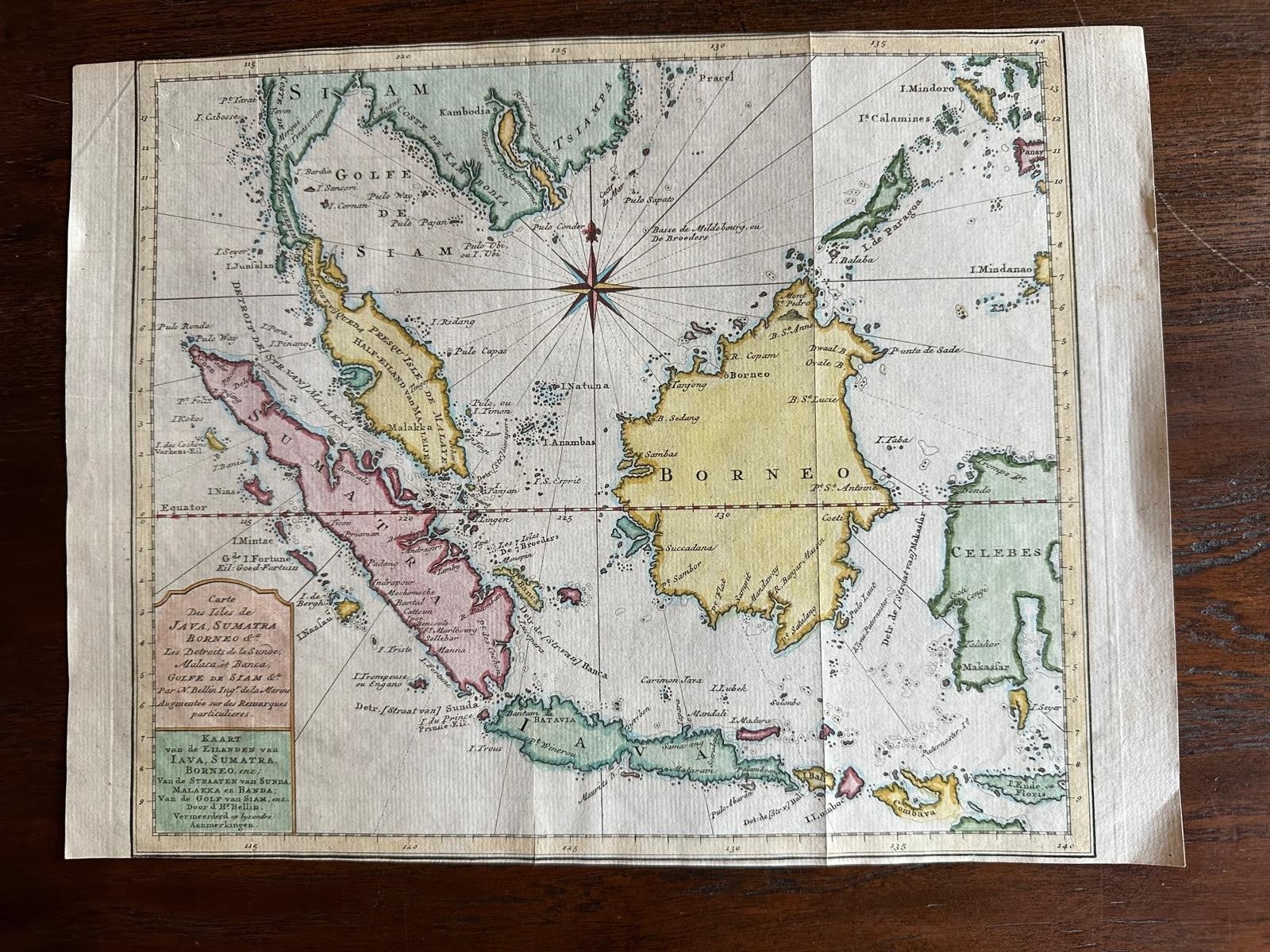
View AllAntique Map of the Sunda Islands Including Sumatra, Java, and Borneo, 1705
Located in Langweer, NL
Title: “Antique Map of the Sunda Islands Including Sumatra, Java, and Borneo”
This print is a beautifully detailed and relatively rare map of Western Indonesia, encompassing the reg...
Category
Antique Early 1700s Maps
Materials
Paper

$826 Sale Price
20% Off
Free Shipping
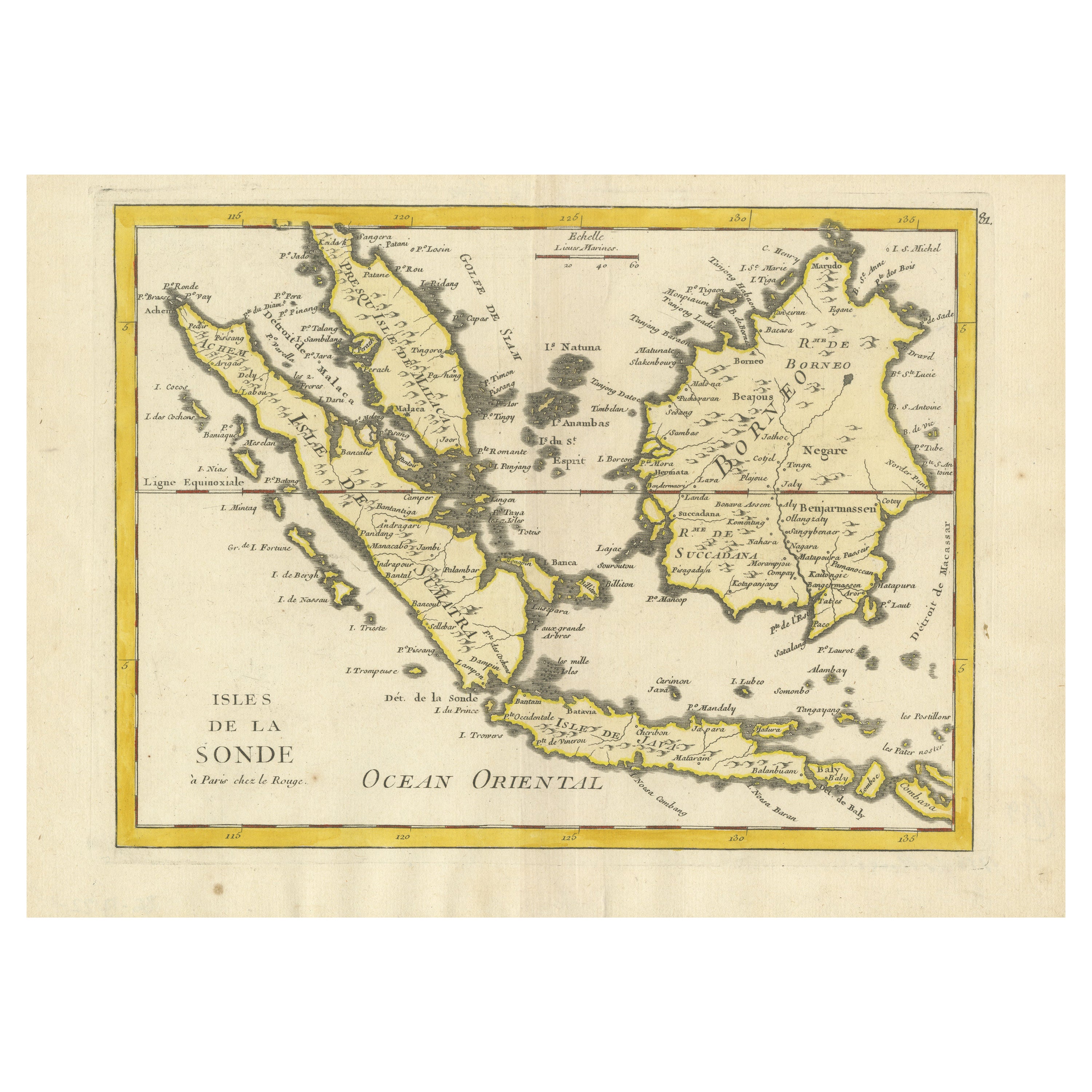
Antique Map of the Sunda Islands by Tirion
c.1760
Located in Langweer, NL
Antique map titled 'Nuova Carta delle Isole di Sunda come Borneo, Sumatra e Iava Grande'. Detailed map of the Sunda Islands, Southeast Asia, extending from the tip of Cambodia to Jav...
Category
Antique Mid-18th Century Maps
Materials
Paper

Antique Map of the Sunda Islands Sumatra, Java, Malay Peninsula
Borneo (1739)
By Isaak Tirion
Located in Langweer, NL
Antique map titled 'Nieuwe kaart van de Sundasche Eilanden als Borneo, Sumatra en Groot Iava & c'. Detailed map of the Sunda Islands, Southeast Asia, extending from the tip of Cambod...
Category
Antique Mid-18th Century Maps
Materials
Paper

$703 Sale Price
21% Off
Original Map of the East Indies Including Sumatra, Java, Borneo
Malaysia, 1755
Located in Langweer, NL
TitlEast Indies map – Java, Sumatra, Borneo & Malay Peninsula, c.1755
Attractive 18th-century map of the East Indies centered on Borneo and the Malay world, showing Sumatra, Java, t...
Category
Antique 1750s Dutch Maps
Materials
Paper
Sea Chart of Part of the Southwestern Coast of Sumatra
Nias, Indonesia, C1775
Located in Langweer, NL
Antique map titled 'Carte de la Côte Occidentale de l'Isle Sumatra'. Sea chart of the part of the south-western coast of Sumatra with the Nassau (Nias) and Fortune isles.
Artists ...
Category
Antique 1770s Maps
Materials
Paper

$486 Sale Price
25% Off
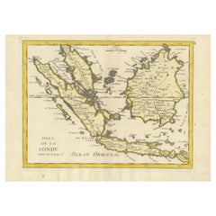
Old Original Antique Map of the Sunda Islands of Indonesia, 1756
Located in Langweer, NL
Title: Isles De La Sonde.
Attractive old decorative map of the Isles de la Sonde, Borneo, Sumatra, Java and Malacca ( Malaysia) with the Straits of Malacca. Penang is spelled as P...
Category
Antique 1750s French Maps
Materials
Paper
$528 Sale Price
20% Off
You May Also Like
West Coast of Africa, Guinea
Sierra Leone: An 18th Century Map by Bellin
By Jacques-Nicolas Bellin
Located in Alamo, CA
Jacques Bellin's copper-plate map entitled "Partie de la Coste de Guinee Dupuis la Riviere de Sierra Leona Jusquau Cap das Palmas", depicting the coast of Guinea and Sierra Leone in ...
Category
Antique Mid-18th Century French Maps
Materials
Paper

$460 Sale Price
20% Off
Antique Map - Mare Pacificum - Etching by Johannes Janssonius - 1650s
By Johannes Janssonius
Located in Roma, IT
Mare Pacificum is an antique map realized in 1650 by Johannes Janssonius (1588-1664).
The Map is Hand-colored etching, with coeval watercolorang.
Good conditions with slight foxing...
Category
1650s Modern Figurative Prints
Materials
Etching

1627 Hendrik Hondius Map Entitled "Vltoniae Orientalis Pars, " Ric.a009
Located in Norton, MA
1627 Hendrik Hondius map entitled
"Vltoniae orientalis pars,"
Ric.a009
Title:
Vltoniae orientalis : pars
Title (alt.) :
Ultoniae orientalis pars
Creator:
Mercator, Gerh...
Category
Antique 17th Century Dutch Maps
Materials
Paper

Antique French Map of Asia Including China Indoneseia India, 1783
Located in Amsterdam, Noord Holland
Very nice map of Asia. 1783 Dedie au Roy.
Additional information:
Country of Manufacturing: Europe
Period: 18th century Qing (1661 - 1912)
Condition: Overall Condition B (Good Used)...
Category
Antique 18th Century European Maps
Materials
Paper

$486 Sale Price
40% Off
Map of the East Indies: An Original 18th Century Hand-colored Map by E. Bowen
Located in Alamo, CA
This is an original 18th century hand-colored map entitled "An Accurate Map of the East Indies Exhibiting the Course of the European Trade both on the Continent and Islands" by Emanu...
Category
Mid-18th Century Old Masters Landscape Prints
Materials
Engraving

$1,020 Sale Price
20% Off
Original Antique Map of South East Asia by Thomas Clerk, 1817
Located in St Annes, Lancashire
Great map of South East Asia
Copper-plate engraving
Drawn and engraved by Thomas Clerk, Edinburgh.
Published by Mackenzie And Dent, 1817
Unframed.
Category
Antique 1810s English Maps
Materials
Paper
