Items Similar to Territories of Antiquity: The Northern Division of Syria, A Detailed 1882 Map

Want more images or videos?
Request additional images or videos from the seller
1 of 11
Territories of Antiquity: The Northern Division of Syria, A Detailed 1882 Map
$268.79
$335.9920% Off
£199.19
£248.9920% Off
€224
€28020% Off
CA$367.36
CA$459.2020% Off
A$399.90
A$499.8720% Off
CHF 212.27
CHF 265.3320% Off
MX$4,811.65
MX$6,014.5620% Off
NOK 2,689.71
NOK 3,362.1320% Off
SEK 2,464.53
SEK 3,080.6620% Off
DKK 1,706.27
DKK 2,132.8420% Off
About the Item
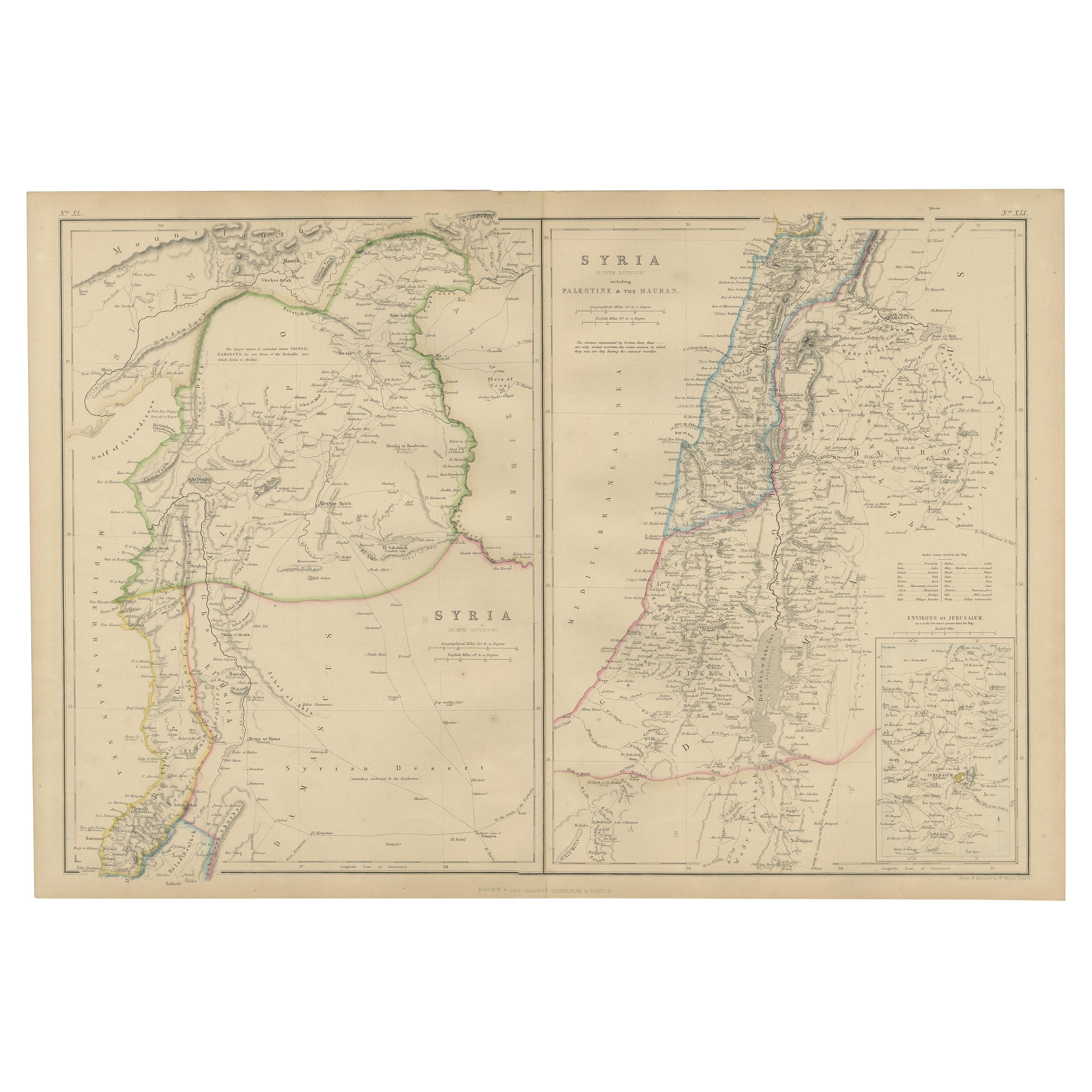
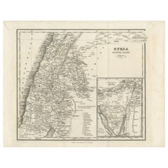
This 19th-century map from the atlas published by Blackie and Son in 1882 is titled "SYRIA (NORTH DIVISION)" and covers the northern part of Syria, capturing its geographical and administrative divisions during the late Ottoman period. The map's scope extends from the Mediterranean Sea in the west, stretching eastward into the expanse of the Syrian Desert, and from the region's northern boundaries down to its central parts.
Color-coded boundaries distinguish the various districts, with topographical features such as mountain ranges and valleys depicted using hachures. The map meticulously charts cities, towns, and villages, and denotes major rivers and bodies of water, reflecting the detailed cartographic practices of the era. The coastline along the Mediterranean is clearly outlined, with ports and coastal cities highlighted, signifying their historical importance as hubs of maritime trade and cultural exchange.
A key feature of the map is the inclusion of historical and biblical references, such as the route of the Apostle Paul’s journey, which underscores the region's rich historical and religious significance. It also indicates caravan routes, which were vital for commerce and communication across the vast desert regions.
The map reflects a time of imperial influence and exploration, where such maps were crucial for navigation, administration, and understanding the complexities of the region's landscape and political territories. It is a window into the past, illustrating how the region was perceived and documented by Western cartographers in the Victorian era. The precision and detail in this map serve as a testament to the advanced state of geographical knowledge and cartographic skill during the 19th century.
- Dimensions:Height: 14.97 in (38 cm)Width: 11.03 in (28 cm)Depth: 0 in (0.02 mm)
- Materials and Techniques:
- Place of Origin:
- Period:
- Date of Manufacture:1882
- Condition:Good condition. Study the image carefully.
- Seller Location:Langweer, NL
- Reference Number:Seller: BG-13601-2-421stDibs: LU3054337696062
About the Seller
5.0
Recognized Seller
These prestigious sellers are industry leaders and represent the highest echelon for item quality and design.
Platinum Seller
Premium sellers with a 4.7+ rating and 24-hour response times
Established in 2009
1stDibs seller since 2017
2,816 sales on 1stDibs
Typical response time: 1 hour
- ShippingRetrieving quote...Shipping from: Langweer, Netherlands
- Return Policy
More From This Seller
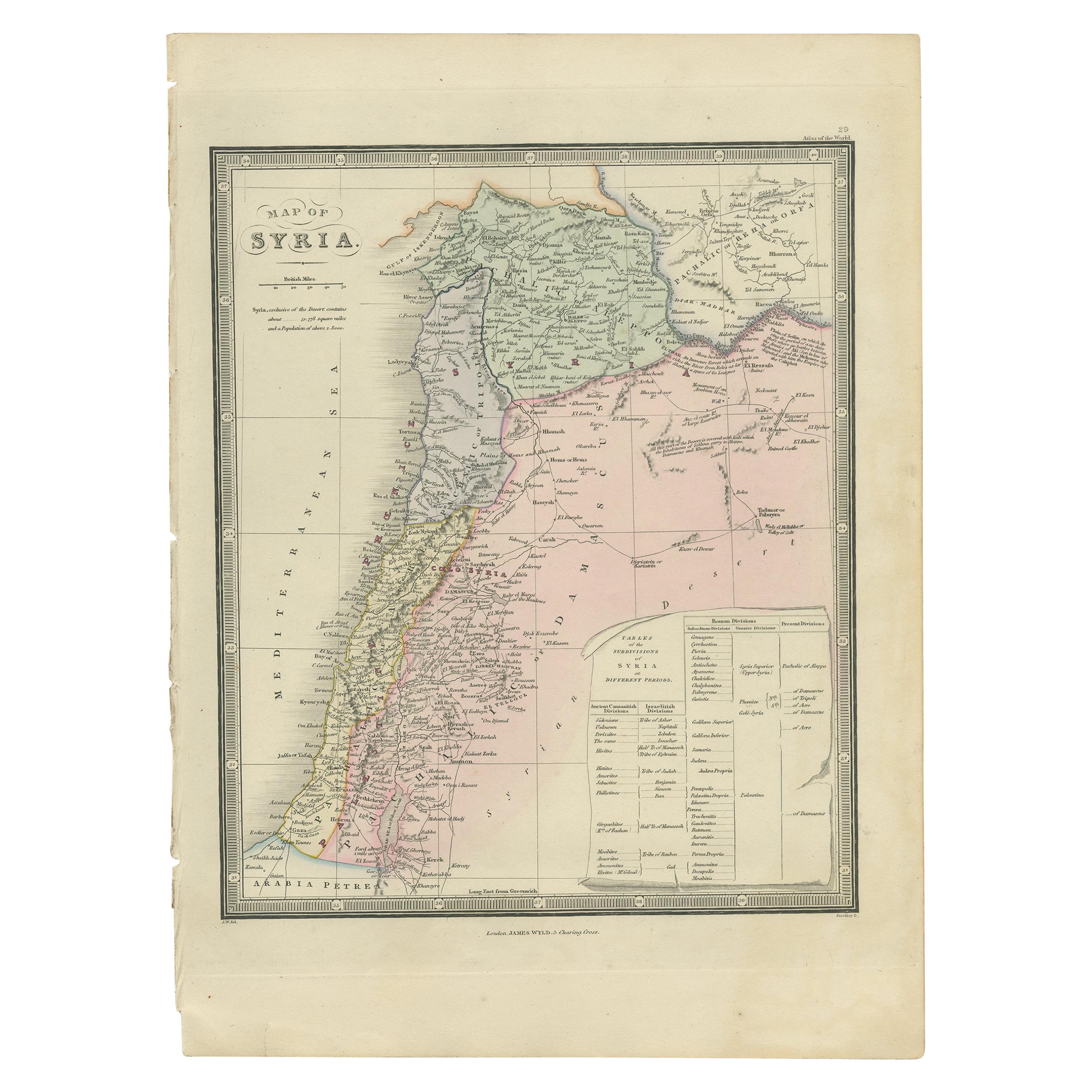
View AllAntique Map of Syria by Wyld
1845
Located in Langweer, NL
Antique map titled 'Map of Syria'. Original antique map of Syria. This map originates from 'An Atlas of the World, Comprehending Separate Maps of its
Var...
Category
Antique Mid-19th Century Maps
Materials
Paper

$239 Sale Price
20% Off
The Divided Realms of Syria - North and South as Seen in 1859 by W. G. Blackie
Located in Langweer, NL
The "Antique Map of Syria, North and South Division" by W. G. Blackie, dated 1859, is a significant historical cartographic work. This map, originating fr...
Category
Antique Mid-19th Century Maps
Materials
Paper

$239 Sale Price
20% Off
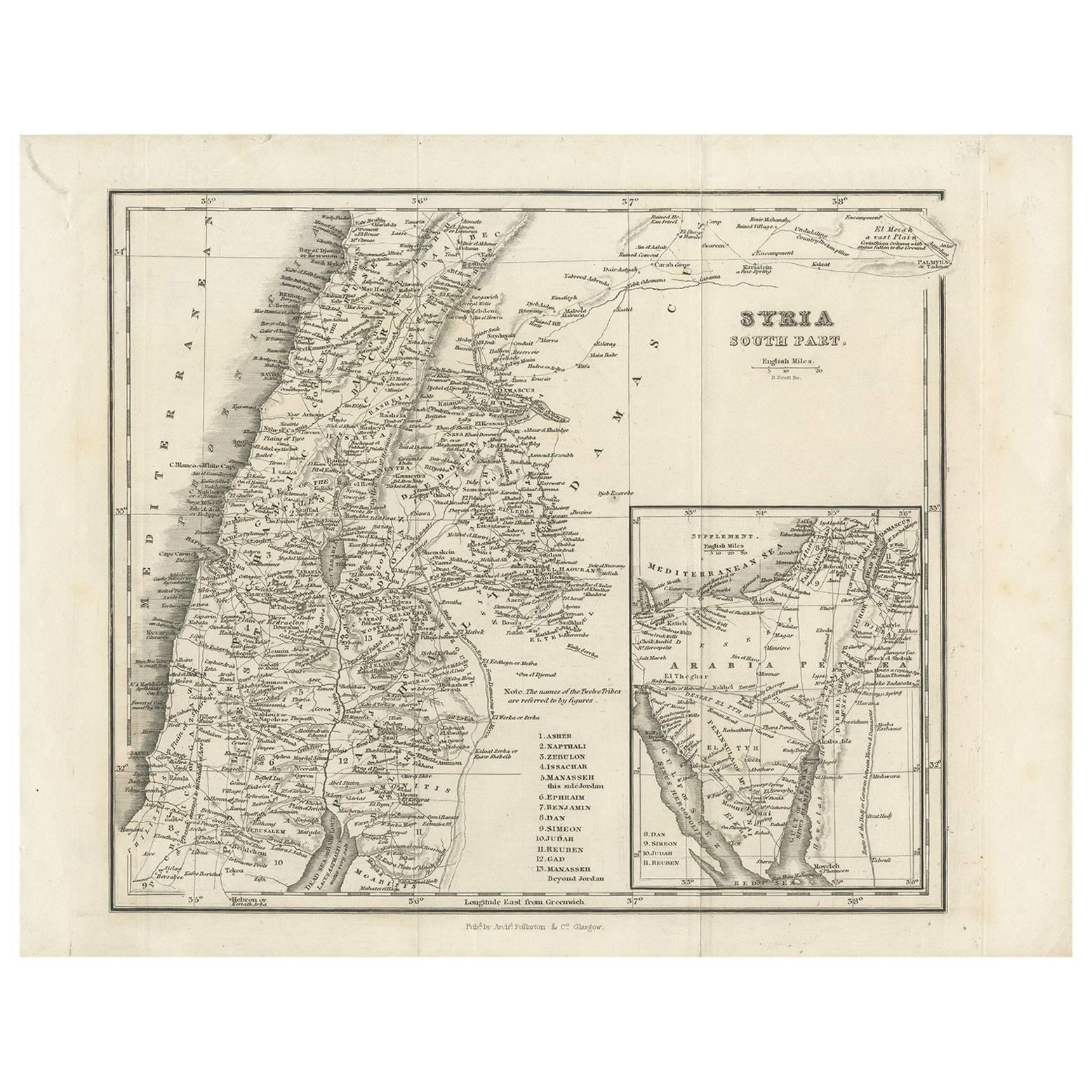
Antique Map of Southern Syria by Fullarton
Co, circa 1860
Located in Langweer, NL
Antique map titled 'Syria south part'. Published by Fullarton & Co, Glasgow, circa 1860.
- Title: Syria South Part
- Publisher: Fullarton & Co, Glasgow
- Date of Publication: Circa ...
Category
Antique Mid-19th Century English Maps
Materials
Paper
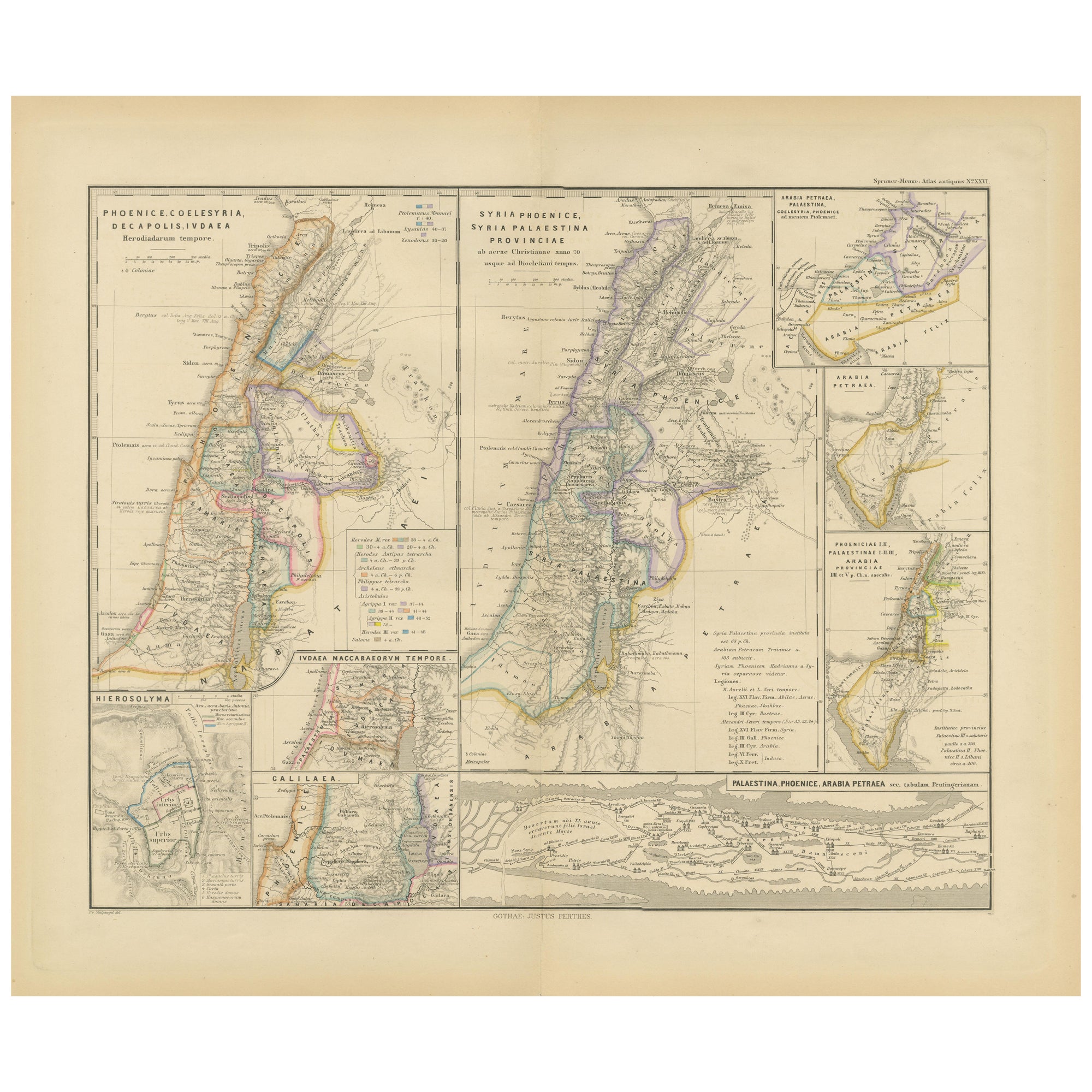
Levant in Antiquity: Lands of Phoenicia, Judea, and Neighboring Kingdoms, 1880
Located in Langweer, NL
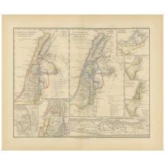
The map is titled "PHOENICE, COELESYRIA, IDUMAEA, JUDAEA MACCABAEORUM TEMPORE," which translates to "Phoenicia, Coele-Syria, Idumea, Judea at the Time of the Maccabees."
This origi...
Category
Antique 1880s Maps
Materials
Paper
$355 Sale Price
20% Off
Free Shipping
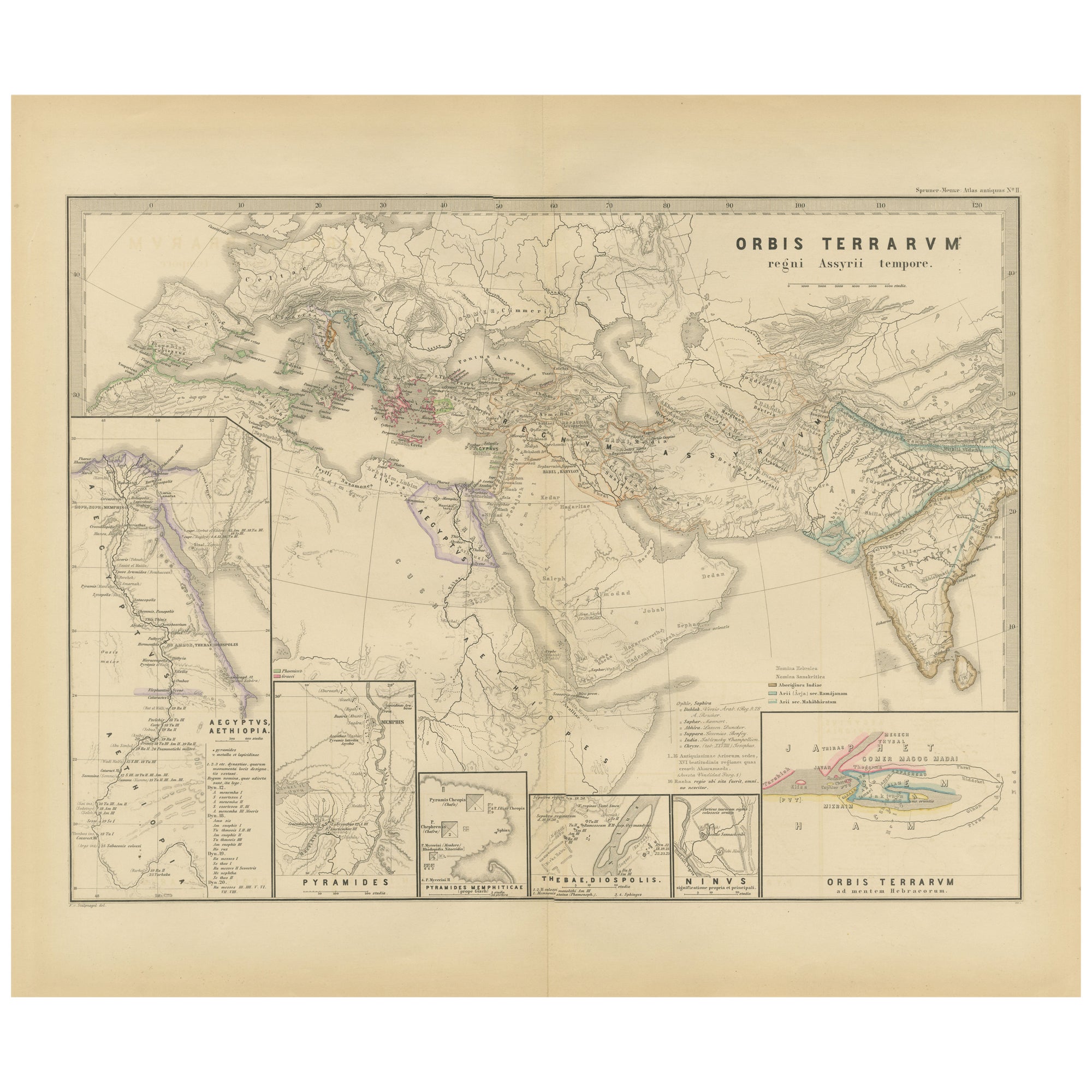
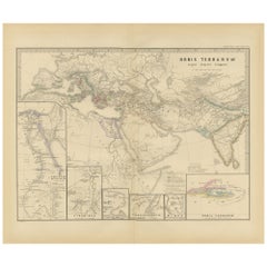
The World in the Assyrian Empire
s Era: A Historical Map, Published in 1880
Located in Langweer, NL
This map from the "Spruner-Menke Atlas Antiquus" is titled "ORBIS TERRARVM regni Assyrii tempore," which translates to "The World at the Time of the Assyrian Kingdom." It depicts the...
Category
Antique 1880s German Maps
Materials
Paper
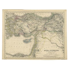
Original Antique Map of the Middle East, Published in Germany, c.1870
Located in Langweer, NL
Antique map titled 'Asia Citerior'. Old map of the Middle East. This map originates from 'Atlas Antiquus, twaalf kaarten behoorende bij de Oude ...
Category
Antique 19th Century Maps
Materials
Paper
You May Also Like
Map of the Holy Land "Carte de la Syrie et de l
Egypte" by Pierre M. Lapie
By Pierre M. Lapie
Located in Alamo, CA
An early 19th century map of ancient Syria and Egypt entitled "Carte de la Syrie et de l'Egypte anciennes/dressée par M. Lapie, Colonel d'Etat Major, et...
Category
Antique Early 19th Century French Maps
Materials
Paper

$620 Sale Price
20% Off
Circa 1825 original engraving of the map of Syria by Giraldon Bovinet
Located in PARIS, FR
The circa 1825 original engraving of "Syrie" by Giraldon Bovinet, based on the work of L. Vivien, is a historically significant map that reflects early 19th-century cartographic tech...
Category
1820s Prints and Multiples
Materials
Paper, Engraving

Ancient National Atlas of France with Marengo
Located in Alessandria, Piemonte
Ancient National Atlas of France with the department of Marengo: a rare French etching dated 1806.
ST/178.
Category
Antique Early 19th Century French Other Prints
Materials
Paper

Map of the Holy Land "Carte de la Syrie et de l
Egypte" by Pierre Lapie
By Pierre M. Lapie
Located in Alamo, CA
This is an early 19th century map of ancient Syria and Egypt entitled "Carte de la Syrie et de l'Egypte anciennes/dressée par M. Lapie, Colonel d'Etat M...
Category
1830s Landscape Prints
Materials
Engraving

Large Original Antique Map of Afghanistan. Edward Weller, 1861
Located in St Annes, Lancashire
Great map of Afghanistan
Lithograph engraving by Edward Weller
Original colour
Published, 1861
Unframed
Good condition
Category
Antique 1860s English Victorian Maps
Materials
Paper

Large Original Antique Map of Cyprus. 1894
Located in St Annes, Lancashire
Superb Antique map of Cyprus
Published Edward Stanford, Charing Cross, London 1894
Original colour
Good condition
Unframed.
Free shipping
Category
Antique 1890s English Maps
Materials
Paper

More Ways To Browse
Antique Syrian
Antique Syrian Furniture
Apostle Paul
Stretcher Tables
M Table
Antique Sultanabad Carpets
China Chair
English Antique Desks
Used Beige Sofa
Antique Plate Germany
Hand Tufted Rugs
Rare China
Side Table Made In Denmark
Thonet Antique
Victorian Hall Tables
Vintage Computer
England Antique Plates
19th Century Round Dining Table