Items Similar to Turkey in Europe
Asia – Ottoman Lands by Bonne c.1780


Want more images or videos?
Request additional images or videos from the seller
1 of 11
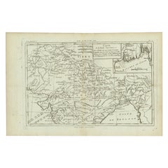
Turkey in Europe
Asia – Ottoman Lands by Bonne c.1780
$420.67
£311.60
€350
CA$575.46
A$627.22
CHF 331.60
MX$7,550.50
NOK 4,208.88
SEK 3,858.68
DKK 2,666.81
About the Item
Turkey in Europe
Asia – Ottoman Lands by Bonne c.1780
DESCRIPTION
This map depicts Ottoman territories across southeastern Europe and western Asia at the height of imperial influence. Engraved by Rigobert Bonne, it presents the Balkans, Anatolia, and surrounding regions with clear emphasis on rivers, cities, and strategic coastlines. The map reflects European interest in Ottoman geography for diplomatic, military, and commercial purposes. Its restrained engraving underscores its function as a reference tool within a scientific atlas.
KEYWORDS
Ottoman Empire map, Constantinople Istanbul, Balkans Anatolia, Black Sea routes, Eastern Mediterranean trade
CONDITION REPORT
Light age toning. Central fold. Minor marginal wear and faint staining.
FRAMING TIPS
Neutral mat and thin black or bronze frame keep focus on geographic detail.
Technique: Engraving
Maker: Rigobert Bonne, France, circa 1780
- Dimensions:Height: 10.24 in (26 cm)Width: 16.15 in (41 cm)Depth: 0.01 in (0.2 mm)
- Materials and Techniques:Paper,Engraved
- Place of Origin:
- Period:
- Date of Manufacture:Circa 1780
- Condition:Light age toning. Central fold. Minor marginal wear and faint staining.
- Seller Location:Langweer, NL
- Reference Number:Seller: BG-14105-71stDibs: LU3054348107872
About the Seller
5.0
Recognized Seller
These prestigious sellers are industry leaders and represent the highest echelon for item quality and design.
Platinum Seller
Premium sellers with a 4.7+ rating and 24-hour response times
Established in 2009
1stDibs seller since 2017
2,813 sales on 1stDibs
Typical response time: 1 hour
- ShippingRetrieving quote...Shipping from: Langweer, Netherlands
- Return Policy
More From This Seller
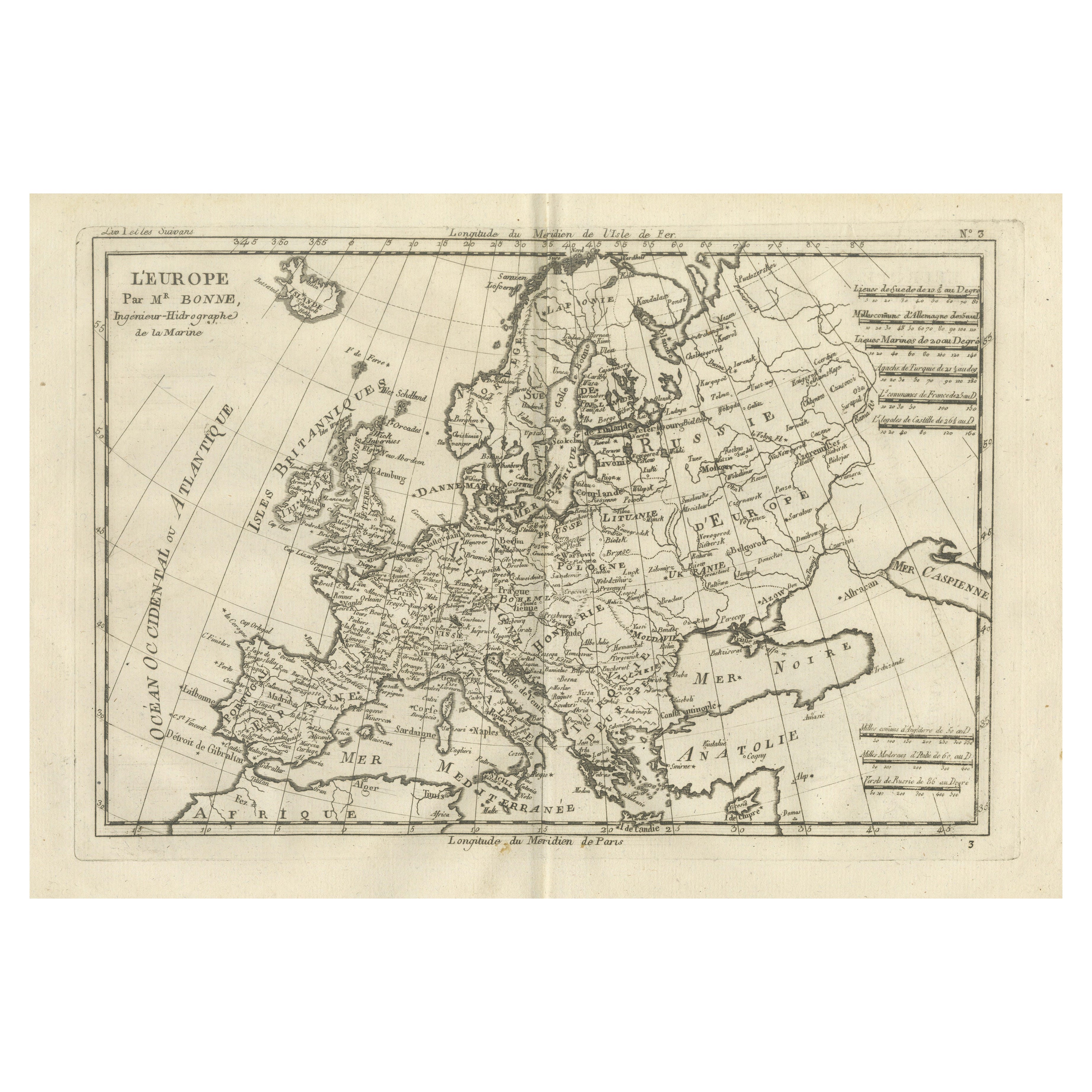
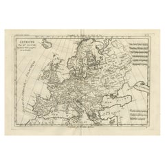
View AllAntique Map of Europe by R. Bonne, 1780
Located in Langweer, NL
A fine example of Rigobert Bonne and Guilleme Raynal’s 1780 map of Europe. Drawn by R. Bonne for G. Raynal’s Atlas de Toutes les Parties Connues du Globe Terrestre, Dressé pour l'His...
Category
Antique Late 18th Century French Maps
Materials
Paper

$151 Sale Price
30% Off
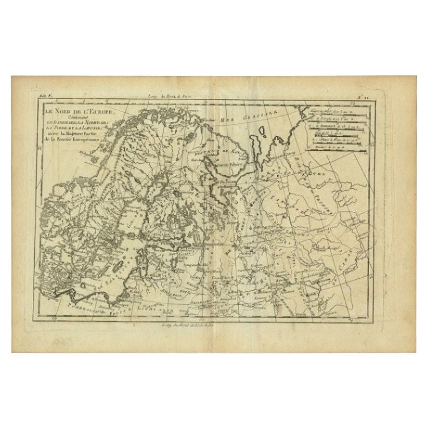
Antique Map of Northern Europe by Bonne, c.1780
Located in Langweer, NL
Antique map titled 'Le Nord de L'Europe, Contenant Le Danemark, La Norwege; La Suede et La Laponie avec la Majeure Partie de al Russie Europeenne.' Map of Northern Europe and Europea...
Category
Antique 18th Century French Maps
Materials
Paper
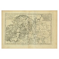
$113 Sale Price
30% Off
Europe Map by Rigobert Bonne – Enlightenment Cartography c.1780
Located in Langweer, NL
Europe Map by Rigobert Bonne – Enlightenment Cartography c.1780
DESCRIPTION
This detailed map of Europe illustrates political and geographic divisions prior to the Napoleonic era. C...
Category
Antique Late 18th Century French Maps
Materials
Paper
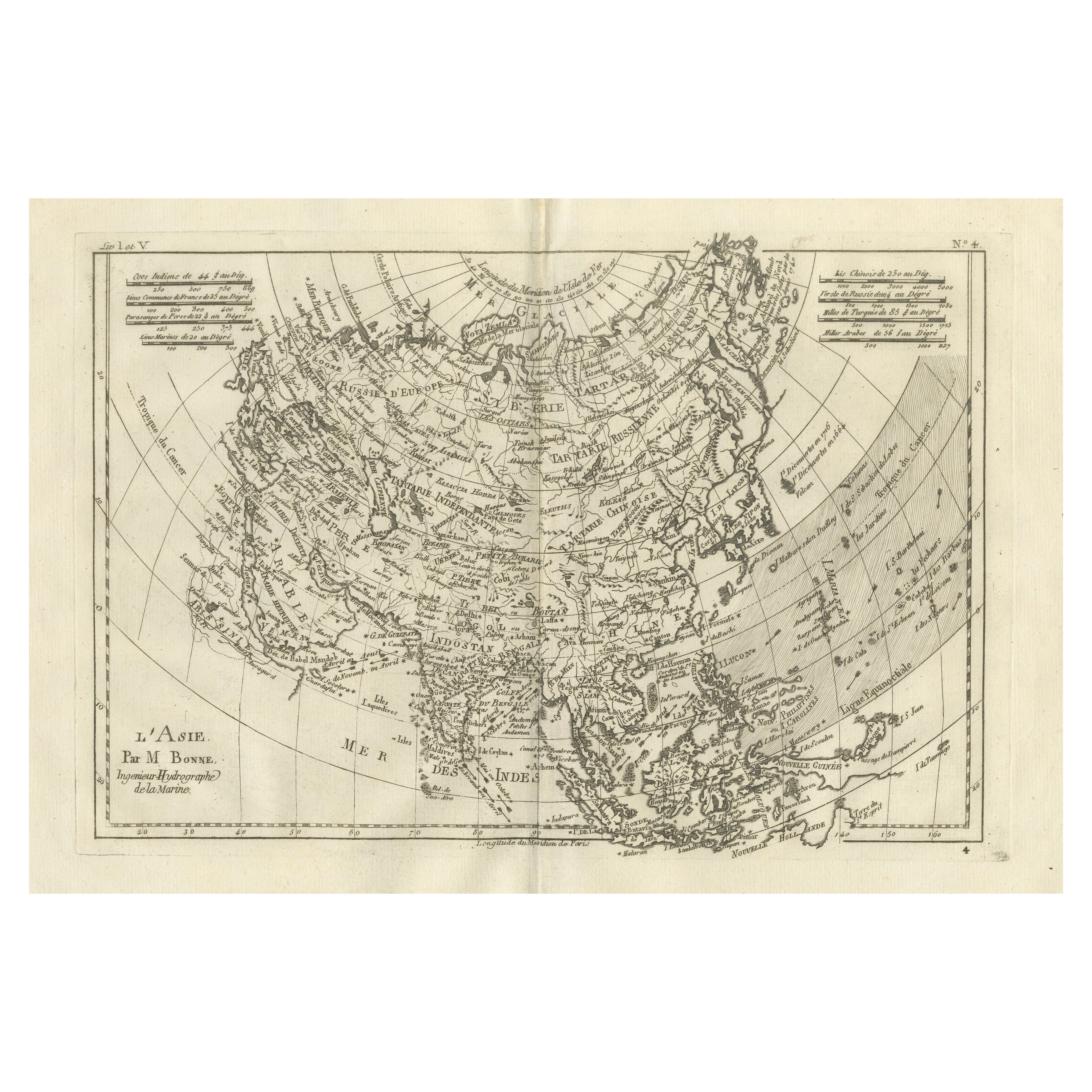
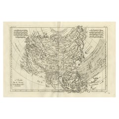
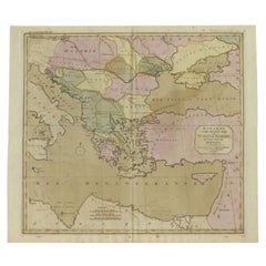
Asia in the Age of Exploration – Antique Map by Rigobert Bonne, c.1780
Located in Langweer, NL
Asia in the Age of Exploration – Antique Map by Rigobert Bonne, c.1780
DESCRIPTION
This engraved map of Asia reflects European geographic understanding during the late Enlightenment...
Category
Antique Late 18th Century French Maps
Materials
Paper
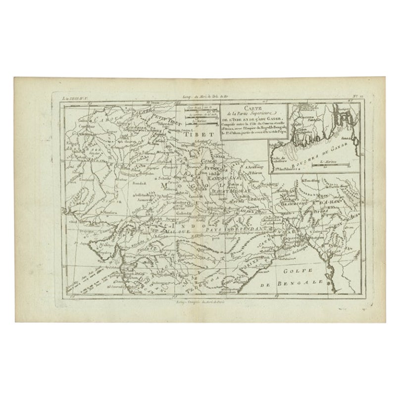
Antique Map of Part of Southern Asia by Bonne, c.1780
Located in Langweer, NL
Antique map titled 'Carte de la Partie Superieure de l'Inde en deca du Gange. Comprise entre la Cote du Concan et celle d'Orixa, avec l'Empire du Mogol, le Bengale, le R. d'Asham, pa...
Category
Antique 18th Century Maps
Materials
Paper
$120 Sale Price
20% Off
Antique Map of Turkey in Europe, c.1780
Located in Langweer, NL
Antique map titled 'Bowles's new pocket map of Turky in Europe divided into its Provinces'. Large map of Turkey in Europe. Source unknown, to be determined.
Artists and Engravers: Made by 'Thomas & Carington Bowles' after an anonymous artist. Thomas Bowles, born around 1712, was map publisher and seller in London...
Category
Antique 18th Century British Maps
Materials
Paper
You May Also Like
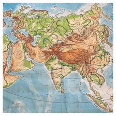
Huge Europe and Asia Vintage Wall Map
Located in San Diego, CA
A huge Europe and Asia vintage wall map, circa 1950s. The map is in fair vintage condition and measures 78"W x 73"H". #2863
Category
Mid-20th Century American Maps
Materials
Paper
$380 Sale Price
20% Off
Map Turkey in Europe
Hungary Thomas Kitchin, 1783
Located in BUNGAY, SUFFOLK
Thomas Kitchen (1718 - 1784) : Map of Turkey in Europe & Hungary 1783
Visible sheet within the cream mount 25.5cm., 10" height 20cm., 8"
In an ebonised frame length 33cm. 13", height 28cm., 11"
Kitchin, Thomas (1718 - 1784)
Thomas Kitchin (August 4, 1718 – June 23, 1784) was a London based engraver, cartographer, and publisher. He was born in London to a hat-dyer of the same name. At 14, Kitchin apprenticed under Emanuel Bowen, under whom he mastered the art of engraving. He married Bowen daughter, Sarah Bowen, and later inherited much of his preceptor's prosperous business. Their son, Thomas Bowen Kitchin, also an engraver joined the family business, which thereafter published in Thomas Kitchin and Son. From 1858 or so Kitchin was the engraver to the Duke of York, and from about 1773 acquired the title, 'Royal Hydrographer to King George III.' He is responsible for numerous maps published in the The Star, Gentleman's Magazine, and London Magazine, as well as partnering with, at various times, with Thomas Jefferys, Emmanuel Bowen, Thomas Hinton, Issac Tayor, Andrew Dury, John Rocque, Louis de la Rochette, and Alexander Hogg, among others. Kitchin passed his business on to his son, Thomas Bowen Kitchin, who continued to republish many of his maps well after his death. Kitchin's apprentices included George Rollos...
Category
Antique 18th Century English Georgian Maps
Materials
Paper

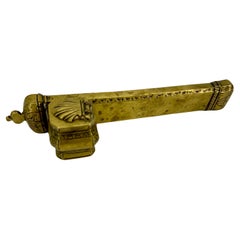
Antique Ottoman Inkwell Qalamdan and Pen Case in Brass, Turkey
Located in Haddonfield, NJ
Antique Turkish Brass Pencil Case Qalamdan and Inkwell From The Ottoman Empire
The interior of the brass case is divided into compartments to ho...
Category
Antique Mid-19th Century Turkish Folk Art Religious Items
Materials
Brass
$364 Sale Price
43% Off
Caravaggism in Europe by Benedict Nicolson
Located in Middletown, NY
Torino: Umberto Allemandi, 1990. Second Edition, Revised and Enlarged by Luisa Vertova.
3 volumes in slipcase with text and 1648 palates covering Caravaggio and Italian Caravaggism...
Category
Late 20th Century Italian Books
Materials
Paper
$1,300 / item
19th Century Ottoman / Turkish Silver Huqqa / Hookah
Located in New York, NY
Antique (19th century) huqqa (hookah) finely crafted from silver, of ovoid form resting on three-legged stand with floral designs around the neck and embossed designs throughout. 20...
Category
Antique Late 19th Century Turkish Tobacco Accessories
Materials
Silver
Pair of Turkish 19th Century Antique Ottoman Embroideries
Located in London, GB
A pair of Turkish 19th century antique Ottoman embroideries
Turkey, 19th century
Small: height 31cm, width 37cm, depth 0.5cm
Large: heigh...
Category
Antique 19th Century Turkish Islamic Religious Items
Materials
Fabric