Items Similar to United States, Canada
Mexico – 1857 North America Map


Video Loading
Want more images or videos?
Request additional images or videos from the seller
1 of 13
United States, Canada
Mexico – 1857 North America Map
$441.23
£326.71
€370
CA$609.44
A$652.71
CHF 350.89
MX$7,927.50
NOK 4,433.67
SEK 4,059.35
DKK 2,819.87
About the Item
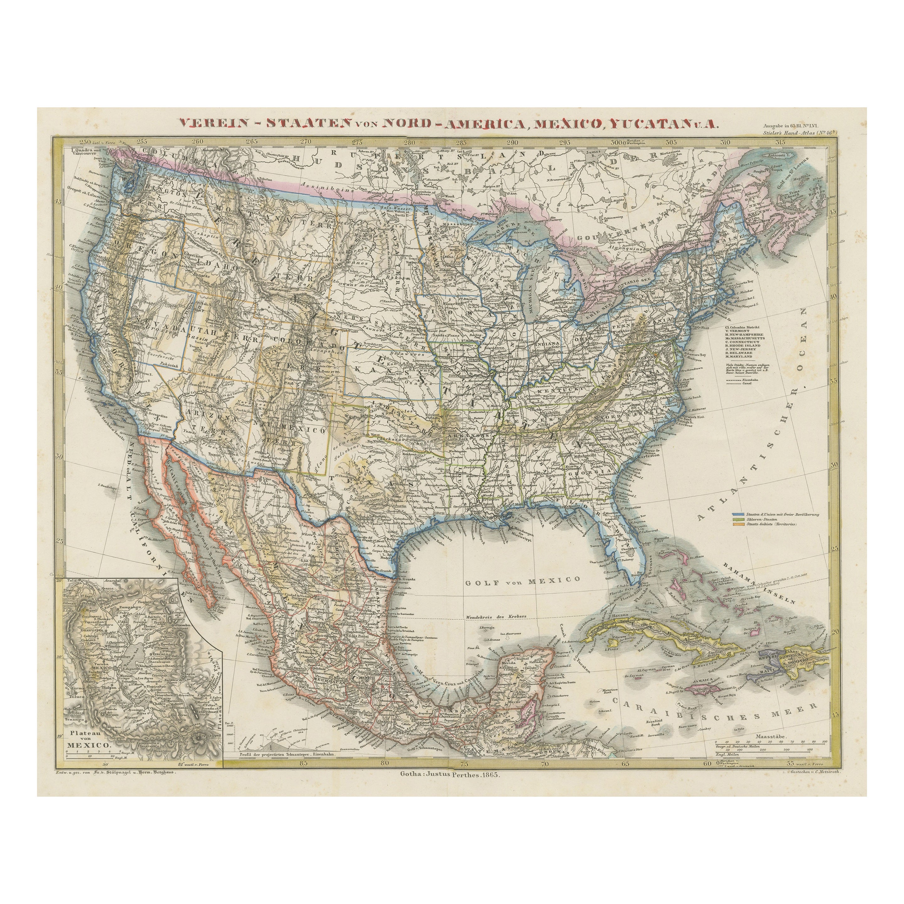
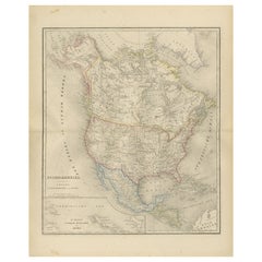
North America Map – United States, Canada, Mexico 1857
This impressive antique print shows “Nord-America” meaning “North America,” published in 1857 by Justus Perthes in Gotha as part of Adolf Stieler’s renowned Hand-Atlas. The map was drawn and engraved by F. v. Stülpnagel, a leading German cartographer of the era.
It presents North America in fine detail, covering Canada, the United States, Mexico, Central America, Greenland, the Caribbean islands, and parts of Alaska labelled here as Russian America. Major features include detailed state and provincial boundaries, mountain ranges such as the Rockies and Appalachians, river systems like the Mississippi and Missouri, and major cities including New York, Washington, Mexico City, and Havana.
This map is significant as it captures North America shortly after the major territorial changes of the mid-19th century, including the 1848 Treaty of Guadalupe Hidalgo that reshaped US-Mexican borders and before the 1867 purchase of Alaska by the United States. It reflects geopolitical realities during a period of rapid expansion, migration, and early industrialisation.
Technique: Copperplate engraving with original hand colouring, used to delineate national borders and territories in subtle yet distinct hues. German titles and annotations are engraved with exceptional clarity characteristic of Stieler’s atlases.
Condition summary: Excellent condition with strong impression, minimal age toning, and no tears, repairs, or significant foxing. Colours remain vivid and paper is firm and stable.
Framing tips: This North America map will display beautifully in a dark wood or black frame to emphasise its historical and geographical presence. Pair with a wide ivory or cream mount to balance its composition and highlight fine engraved details. UV-protective glass is recommended to preserve the engraving lines and original colouring for long-term display.
- Dimensions:Height: 14.77 in (37.5 cm)Width: 17.88 in (45.4 cm)Depth: 0.01 in (0.2 mm)
- Materials and Techniques:Paper,Engraved
- Place of Origin:
- Period:
- Date of Manufacture:1857
- Condition:Condition summary: Excellent condition with strong impression, minimal age toning, and no tears, repairs, or significant foxing. Colours remain vivid and paper is firm and stable.
- Seller Location:Langweer, NL
- Reference Number:Seller: BG-05552-511stDibs: LU3054345814462
About the Seller
5.0
Recognized Seller
These prestigious sellers are industry leaders and represent the highest echelon for item quality and design.
Platinum Seller
Premium sellers with a 4.7+ rating and 24-hour response times
Established in 2009
1stDibs seller since 2017
2,826 sales on 1stDibs
Typical response time: 1 hour
- ShippingRetrieving quote...Shipping from: Langweer, Netherlands
- Return Policy
More From This Seller
View AllNorth America Map with USA, Canada
Mexico – Nieuwe Hand-Atlas, 1876
Located in Langweer, NL
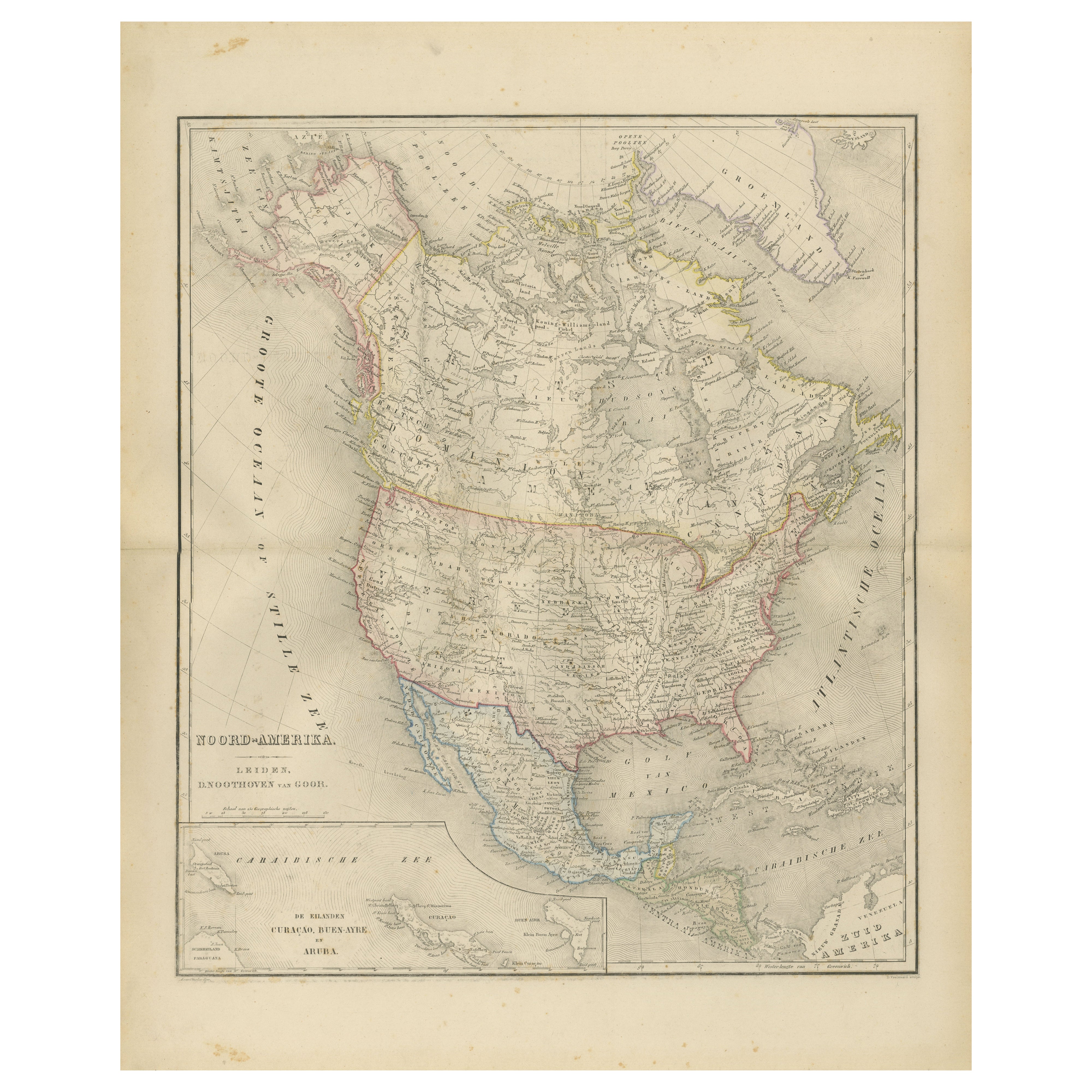
North America Map with USA, Canada & Mexico – Nieuwe Hand-Atlas, 1876
This finely engraved 19th-century map of “Noord-Amerika,” published in 1876 by D. Noothoven van Goor of Leiden ...
Category
Antique 1870s Dutch Maps
Materials
Paper
North America Antique Railroad Map c.1888 – U.S., Canada
Mexico
Located in Langweer, NL
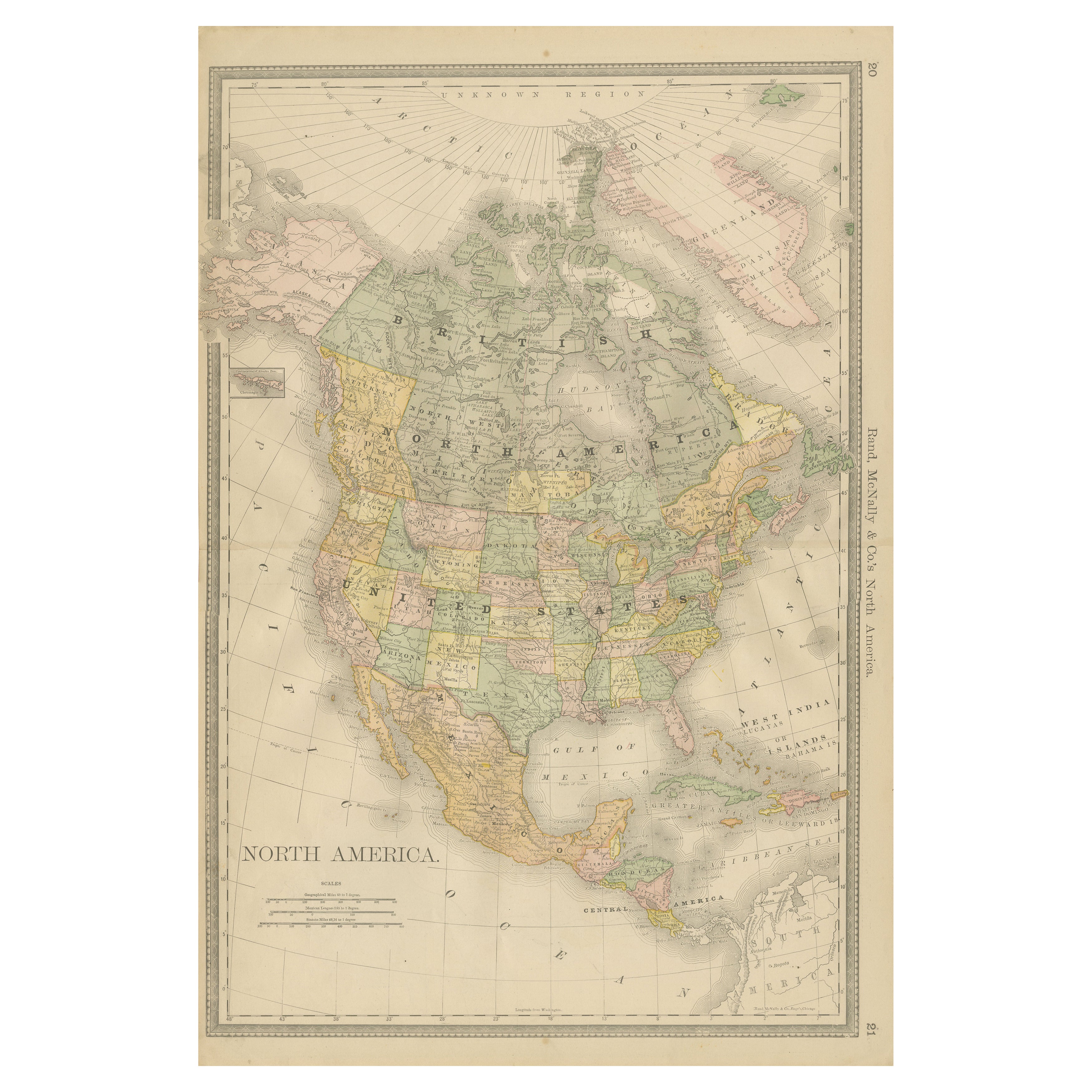
Antique Map of North America – Rand McNally, circa 1888
This antique map of North America, published by Rand, McNally & Co. circa 1888, offers a comprehensive view of the continent ...
Category
Antique Late 19th Century American Maps
Materials
Paper
Explore North America in 1903 - Intricately Detailed Antique Map
Located in Langweer, NL
North America, 1903 - A Colorful Historical Map with Detailed Borders
This attractive map of North America was engraved, printed, and published by W. & A.K. Johnston in 1903. A wond...
Category
Early 20th Century Maps
Materials
Paper
Antique Map of North America, 1821
Located in Langweer, NL
Antique map of America titled 'Carte de l'Amerique septentrionale'. Scarce map of North America, shortly after the Louisiana Purchase and the first ...
Category
Antique 19th Century French Maps
Materials
Paper

$620 Sale Price
20% Off
United States, Mexico
West Indies Map – Nieuwe Hand-Atlas, 1876
Located in Langweer, NL
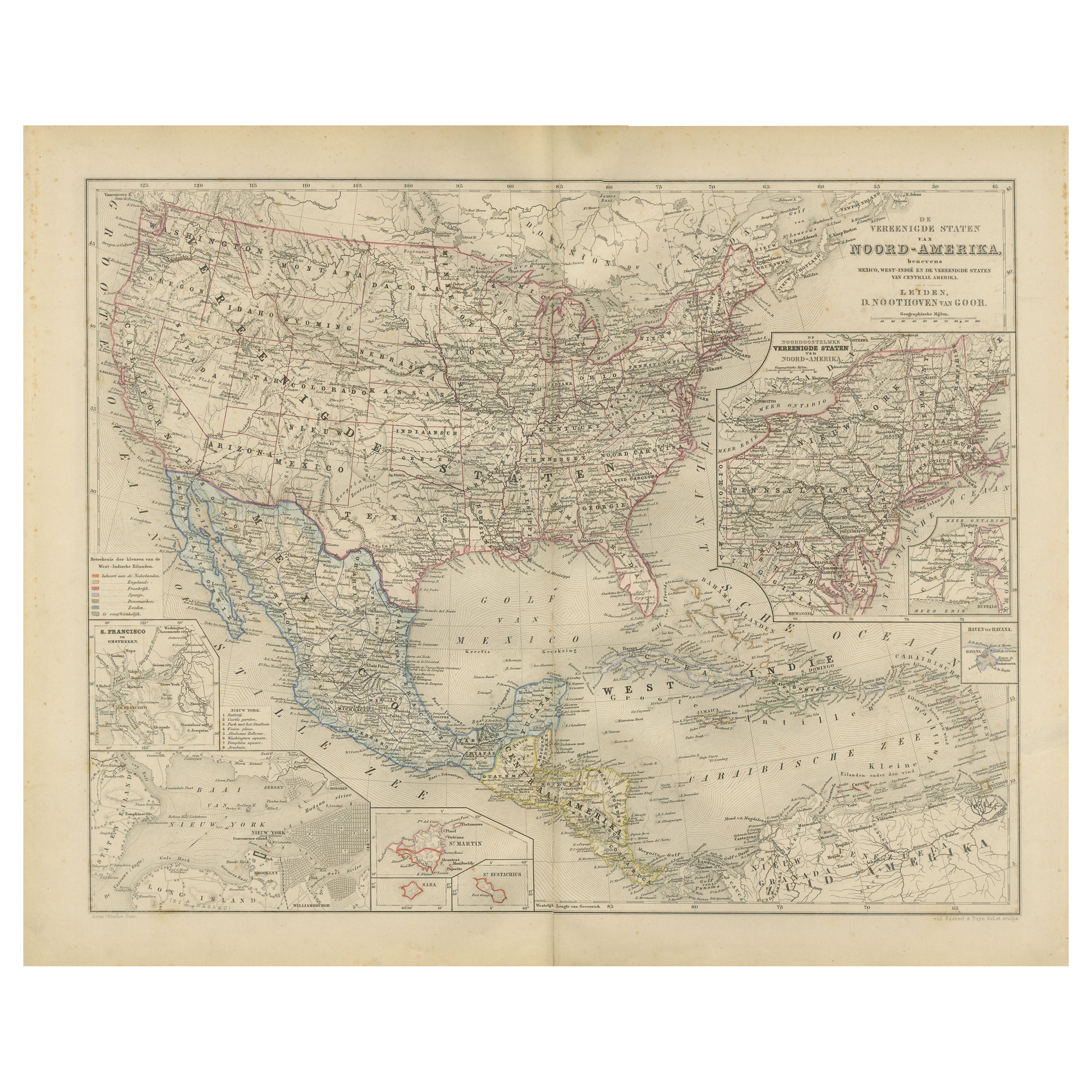
United States, Mexico & West Indies Map – Nieuwe Hand-Atlas, 1876
This richly detailed 1876 map, titled “De Vereenigde Staten van Noord-Amerika, Mexico, West-Indië en de Vereenigde ...
Category
Antique 1870s Dutch Maps
Materials
Paper
Antique Map of the United States of America, also showing the Caribbean
Located in Langweer, NL
Antique map titled 'Verein-Staaten von Nord-America, Mexico, Yucatan u.a.'. Very detailed map of the United States of America showing the ...
Category
Antique Mid-19th Century Maps
Materials
Paper

$782 Sale Price
20% Off
You May Also Like
North America. Century Atlas antique vintage map
Located in Melbourne, Victoria
'The Century Atlas. North America'
Original antique map, 1903.
Central fold as issued. Map name and number printed on the reverse corners.
Sheet 40cm by 29.5cm.
Category
Early 20th Century Victorian More Prints
Materials
Lithograph

Original Antique Map of North America by Dower, circa 1835
Located in St Annes, Lancashire
Nice map of North America
Drawn and engraved by J.Dower
Published by Orr & Smith. C.1835
Unframed.
Free shipping
Category
Antique 1830s English Maps
Materials
Paper

Large Original Vintage Map of North America, circa 1920
Located in St Annes, Lancashire
Great map of North America
Original color. Good condition
Published by Alexander Gross
Unframed.
Category
Vintage 1920s English Edwardian Maps
Materials
Paper

Original Antique Map of The United States of America by Dower, circa 1835
Located in St Annes, Lancashire
Nice map of the USA
Drawn and engraved by J.Dower
Published by Orr & Smith. C.1835
Unframed.
Free shipping
Category
Antique 1830s English Maps
Materials
Paper

Large 1848 North America
Territories Map
Located in Stamford, CT
Framed 1848 S. Augustus and Mitchell, Philadelphia , PA North America and territories map.
Featuring the United States, Canada (British Territory) and Mexican Territories.
As found...
Category
Antique 1840s American American Classical Maps
Materials
Glass, Wood, Paper

Original Antique Map of United States, Grattan and Gilbert, 1843
Located in St Annes, Lancashire
Great map of United States
Drawn and engraved by Archer
Published by Grattan and Gilbert. 1843
Original colour
Unframed.
Category
Antique 1840s English Maps
Materials
Paper

More Ways To Browse
Antique Mexican Furniture
Beni Ourain Rugs
Glass Top Wood Base Coffee Tables
T Chair
Pair Of Danish Chairs
Veneer Dining Tables
1970 Italian Armchair
Furniture Uk
House Of Denmark Table And Chairs
Louis Marble Top Side Table
Antique Russian Rugs
Baker Furniture By
For Kids
Sterling Silver Flatware Set Service For 12
Tufted Bar
Pair Of French Antique Armchairs
1970s Brass Glass Coffee Table
Antique Column Base