Items Similar to United States, Mexico
West Indies Map – Nieuwe Hand-Atlas, 1876
Want more images or videos?
Request additional images or videos from the seller
1 of 11
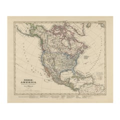
United States, Mexico
West Indies Map – Nieuwe Hand-Atlas, 1876
$467.98
£346.81
€390
CA$639.60
A$696.25
CHF 369.57
MX$8,377.42
NOK 4,682.97
SEK 4,290.92
DKK 2,970.75
About the Item
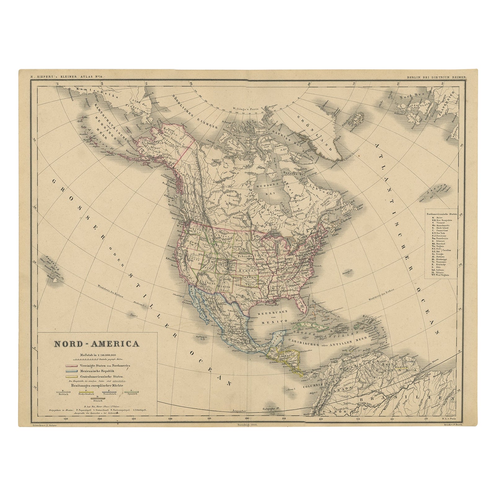
United States, Mexico
West Indies Map – Nieuwe Hand-Atlas, 1876
This richly detailed 1876 map, titled “De Vereenigde Staten van Noord-Amerika, Mexico, West-Indië en de Vereenigde Staten van Colombia,” was published in Leiden by D. Noothoven van Goor for the *Nieuwe Hand-Atlas der Aarde*. It offers an exceptionally comprehensive view of the United States and its neighboring regions during a pivotal period of growth and reconstruction following the American Civil War.
The map captures the United States with its post-1870 state boundaries firmly established, including the large western territories that had not yet achieved statehood. Regions such as Montana, Dakota, Wyoming, New Mexico, Arizona, and Indian Territory appear in their expansive territorial forms, offering historical insight into the administrative geography of the period. Major railroads, wagon routes, and early towns are displayed with fine engraving, revealing the rapid infrastructural expansion across the continent.
Mexico is presented with clear provincial boundaries and dense labeling of cities, mountain ranges, and rivers. The depiction reflects the territorial configuration after the loss of the northern regions to the United States in the mid-19th century, showing Mexico in a more stable national form following decades of upheaval.
The Caribbean and West Indies section is exceptionally rich, illustrating Cuba, Jamaica, Hispaniola, Puerto Rico, the Lesser Antilles, and the coastline of northern South America. Insets highlight strategic and commercially important locations, including New York, San Francisco, Havana, Martinique, Guadeloupe, and St. Eustatius. These add valuable geographic context and emphasize the maritime networks that connected North America with the Caribbean and the wider Atlantic world.
The map also includes a detailed inset of the eastern United States, showing population centers, rail lines, and industrial hubs with great clarity. Another inset focuses on San Francisco and its bay area, reflecting the post–Gold Rush transformation of California into a major Pacific gateway.
Engraved with precision and finished with subtle hand-applied color outlining borders, this map exemplifies the high production standards of late 19th-century Dutch cartography. It is both historically important and visually compelling, capturing an era of continental expansion, migration, and emerging national identities.
This plate is ideal for collectors of American history, early U.S. territorial maps, Mexican cartography, and the colonial-era Caribbean.
Condition report:
Good condition with typical age toning and light scattered foxing, mostly in the margins. Original center fold as issued. Image area sharp with crisp engraving and well-preserved hand-coloring. No tears or repairs observed.
Framing tips:
A warm ivory or off-white mat highlights the subtle pastel border colors. A walnut, black, or thin gold frame complements the period style. Because this is a large horizontal map, a wide mat margin helps balance the composition and create a gallery-quality presentation.
Keyword block:
United States, Mexico, West Indies, Caribbean, Cuba, Jamaica, Puerto Rico, Hispaniola, Central America, New York, San Francisco, Havana, Martinique, Guadeloupe, St. Eustatius, Gulf of Mexico, Atlantic Ocean, Pacific Coast, Western Territories, Indian Territory, 19th century map, 1876, Nieuwe Hand-Atlas, D. Noothoven van Goor, historical cartography.
- Dimensions:Height: 17.33 in (44 cm)Width: 21.66 in (55 cm)Depth: 0.01 in (0.2 mm)
- Materials and Techniques:
- Place of Origin:
- Period:
- Date of Manufacture:1876
- Condition:Good condition with typical age toning and light scattered foxing, mostly in the margins. Original center fold as issued. Image area sharp with crisp engraving and well-preserved hand-coloring. No tears or repairs observed.
- Seller Location:Langweer, NL
- Reference Number:Seller: BG-12788-281stDibs: LU3054347571212
About the Seller
5.0
Recognized Seller
These prestigious sellers are industry leaders and represent the highest echelon for item quality and design.
Platinum Seller
Premium sellers with a 4.7+ rating and 24-hour response times
Established in 2009
1stDibs seller since 2017
2,819 sales on 1stDibs
Typical response time: 1 hour
- ShippingRetrieving quote...Shipping from: Langweer, Netherlands
- Return Policy
More From This Seller
View AllNorth America Map with USA, Canada
Mexico – Nieuwe Hand-Atlas, 1876
Located in Langweer, NL
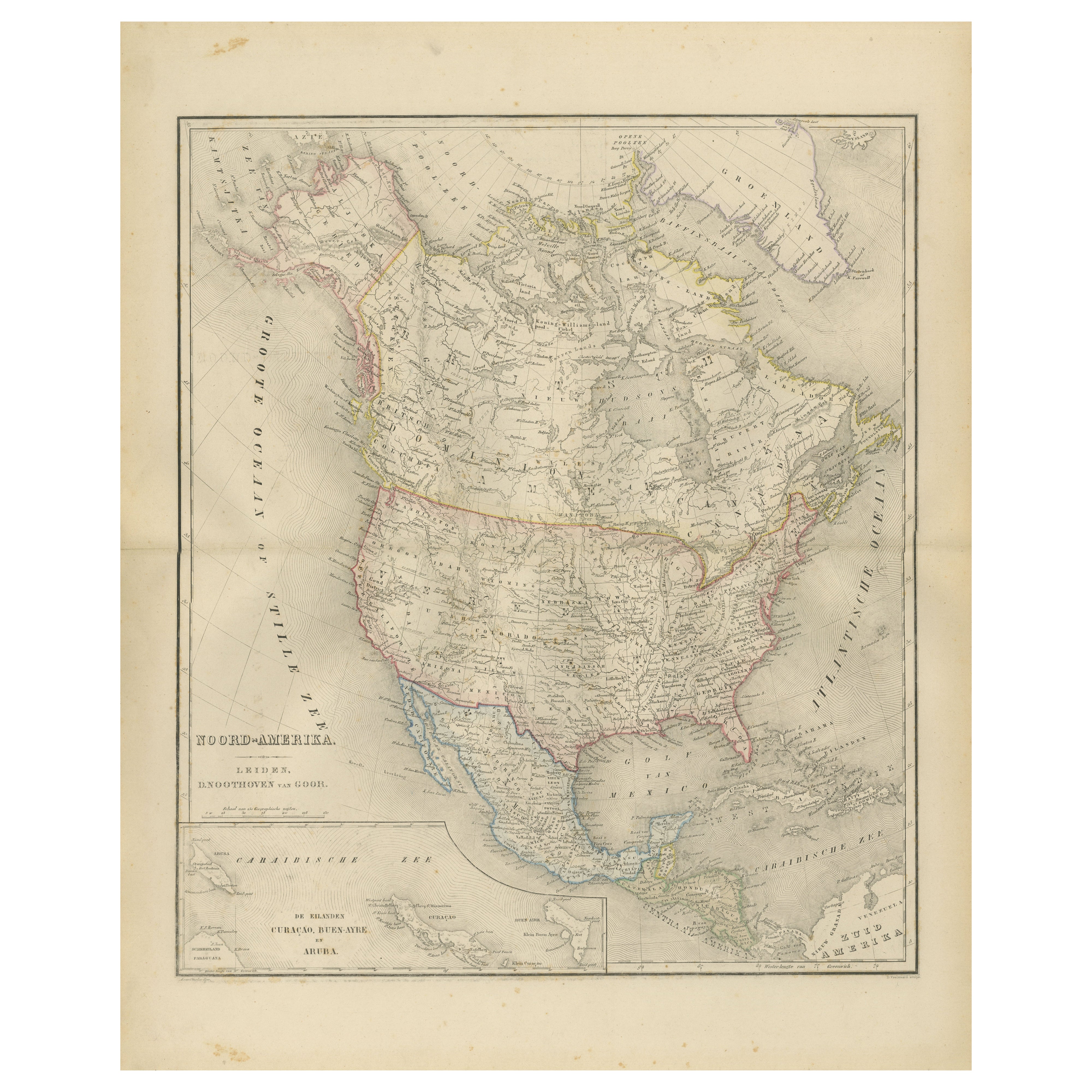
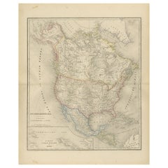
North America Map with USA, Canada & Mexico – Nieuwe Hand-Atlas, 1876
This finely engraved 19th-century map of “Noord-Amerika,” published in 1876 by D. Noothoven van Goor of Leiden ...
Category
Antique 1870s Dutch Maps
Materials
Paper
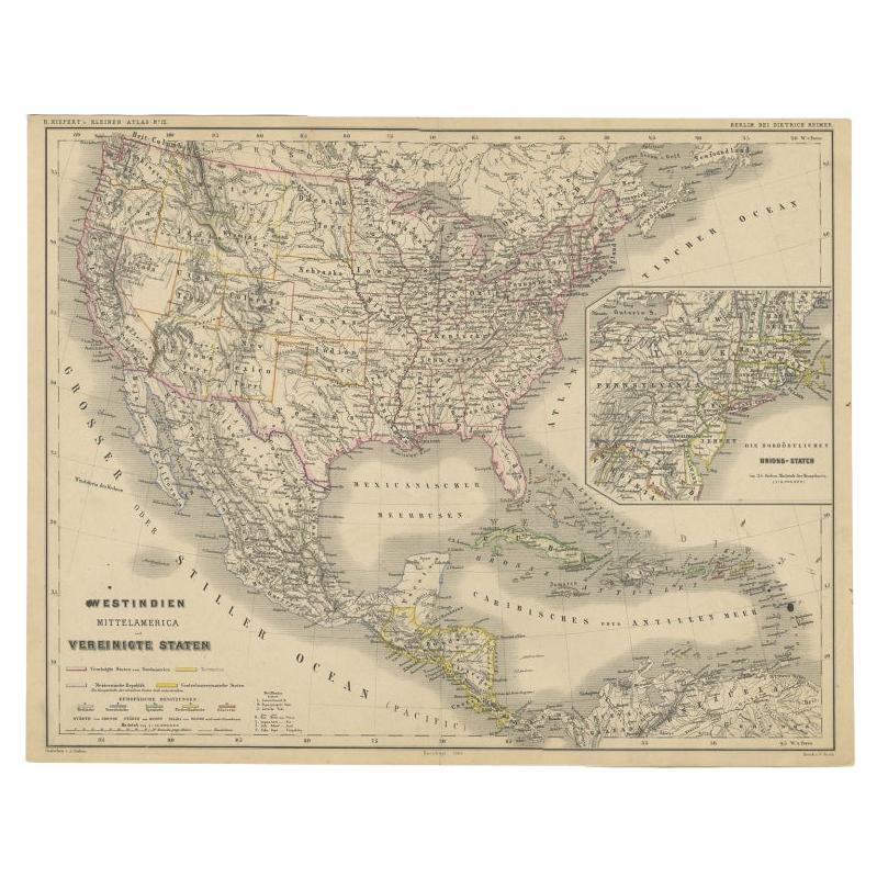
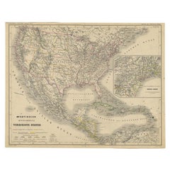
Old German Map of the United States, Central America and the West Indies, c.1870
Located in Langweer, NL
Antique map titled 'Westindien, Mittelamerica und Vereinigte Staten'. Old map of the United States, Central America and the West Indies. This map originates from 'H. Kiepert's Kleine...
Category
Antique 19th Century Maps
Materials
Paper
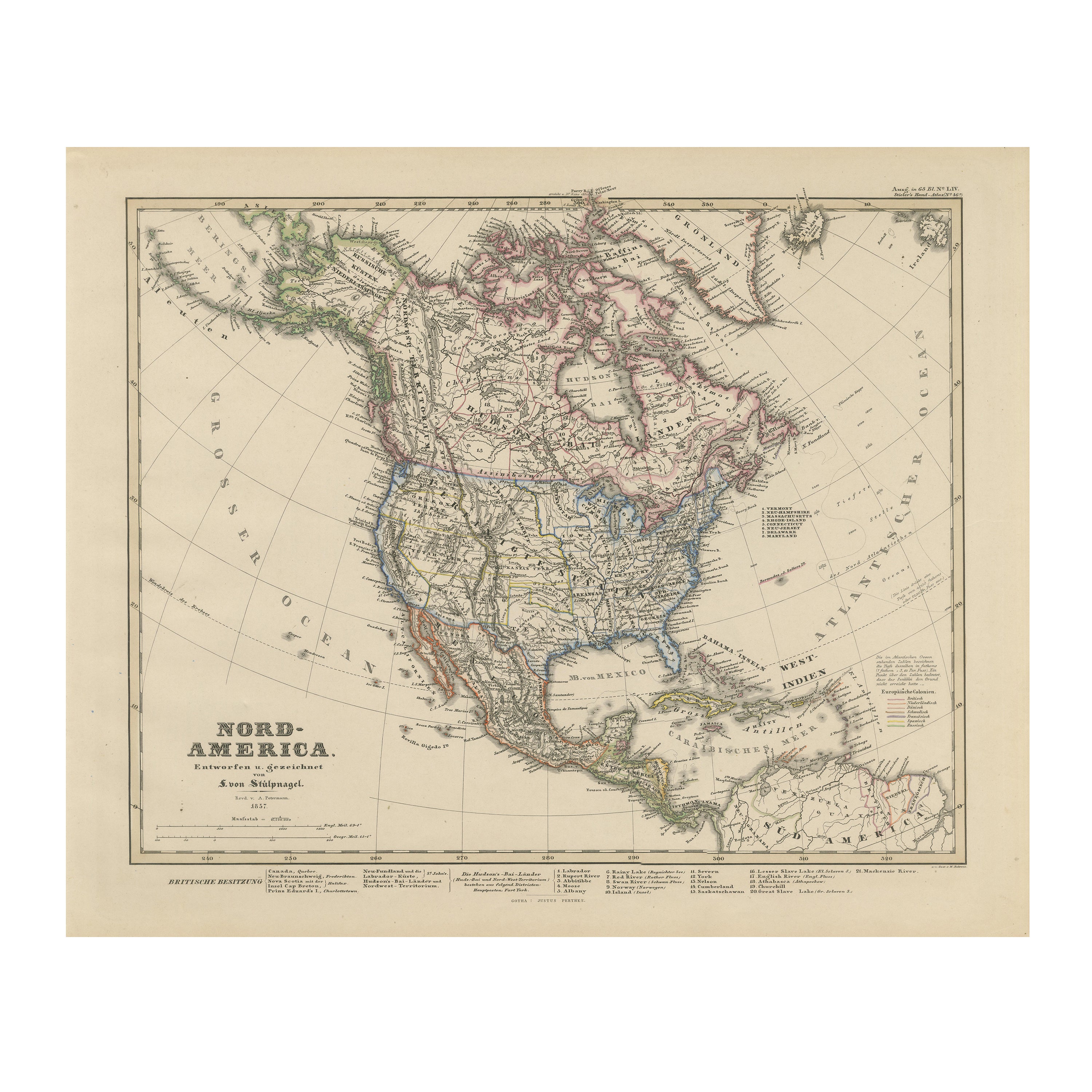
United States, Canada
Mexico – 1857 North America Map
Located in Langweer, NL
North America Map – United States, Canada, Mexico 1857
This impressive antique print shows “Nord-America” meaning “North America,” published in 1857 by Justus Perthes in Gotha as pa...
Category
Antique Mid-19th Century German Maps
Materials
Paper
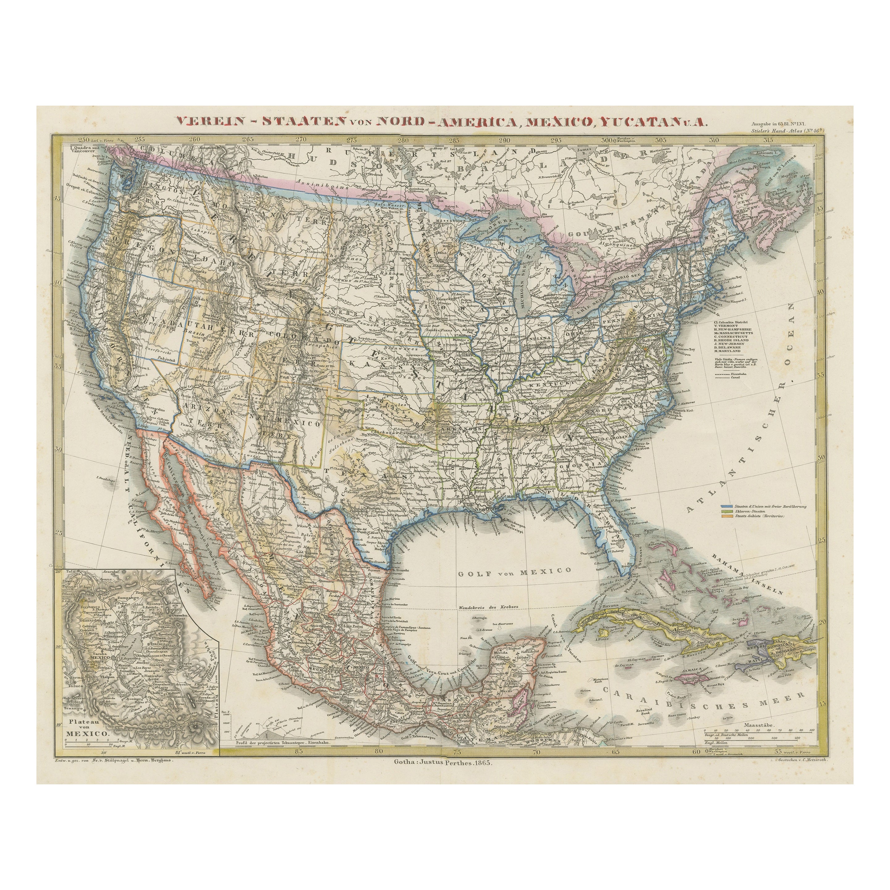
Antique Map of the United States of America, also showing the Caribbean
Located in Langweer, NL
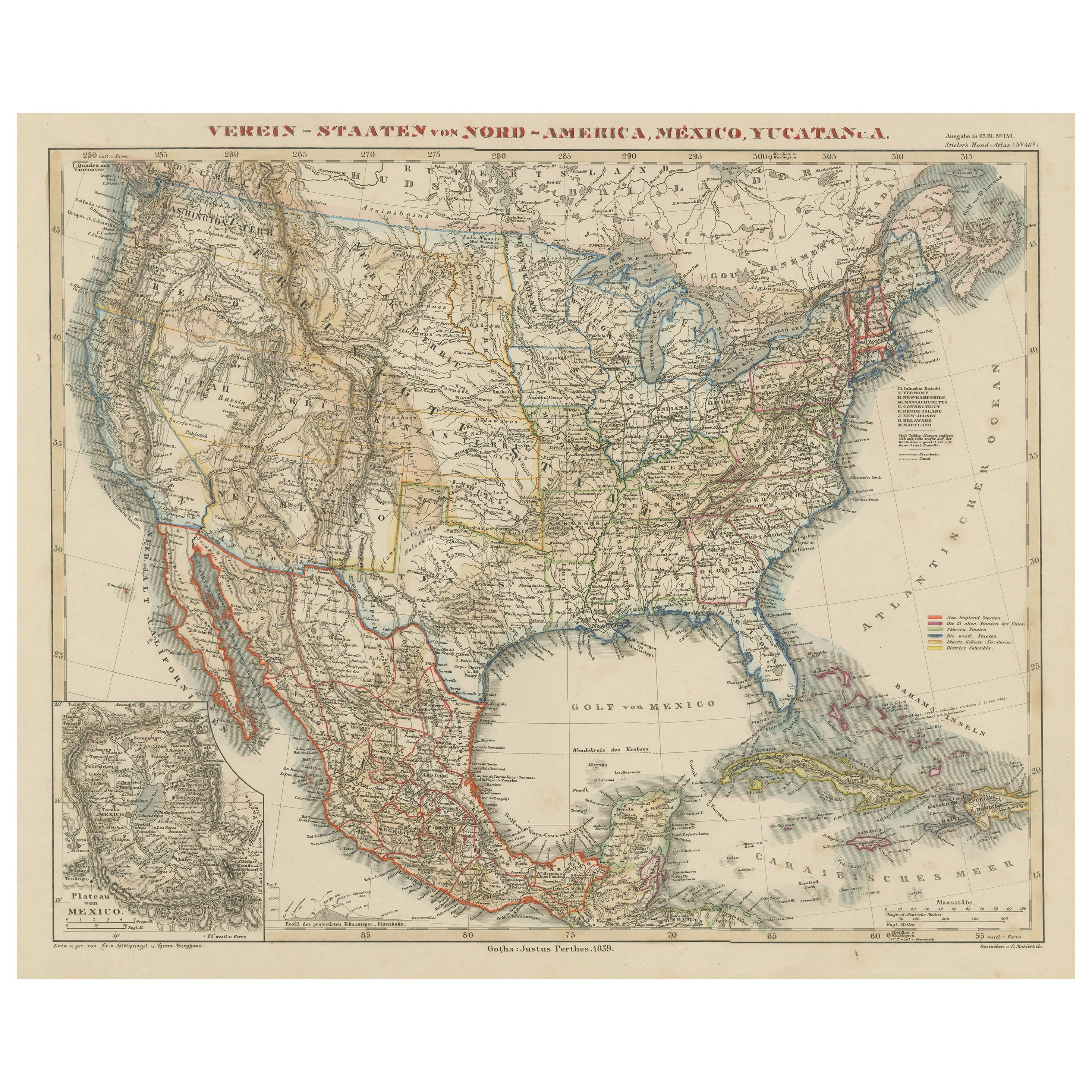
Antique map titled 'Verein-Staaten von Nord-America, Mexico, Yucatan u.a.'. Very detailed map of the United States of America showing the ...
Category
Antique Mid-19th Century Maps
Materials
Paper

$787 Sale Price
20% Off
Antique Map of the United States with inset map of the region of Mexico City
Located in Langweer, NL
Antique map titled 'Verein-Staaten von Nord-America, Mexico, Yucatan u.a.'. Very detailed map of the United States of America showing the Caribbean. With an inset map of the surround...
Category
Antique Mid-19th Century Maps
Materials
Paper

$825 Sale Price
20% Off
Old Original Antique German Map of North America, ca.1870
Located in Langweer, NL
Antique map titled 'Nord-America'.
Old map of North America. This map originates from 'H. Kiepert's Kleiner Atlas der Neueren Geographie für Schule und Haus'.
Artists and Engrave...
Category
Antique 1870s German Maps
Materials
Paper

$382 Sale Price
35% Off
You May Also Like
Mexico. Century Atlas antique vintage map
Located in Melbourne, Victoria
'The Century Atlas. Mexico.'
Original antique map, 1903.
Central fold as issued. Map name and number printed on the reverse corners.
Sheet 29.5cm by 40cm.
Category
Early 20th Century Victorian More Prints
Materials
Lithograph
Original Antique Map of The United States of America by Dower, circa 1835
Located in St Annes, Lancashire
Nice map of the USA
Drawn and engraved by J.Dower
Published by Orr & Smith. C.1835
Unframed.
Free shipping
Category
Antique 1830s English Maps
Materials
Paper

Original Antique Map of Central America / Florida, Arrowsmith, 1820
Located in St Annes, Lancashire
Great map of Central America.
Drawn under the direction of Arrowsmith.
Copper-plate engraving.
Published by Longman, Hurst, Rees, Orme and Brown, 1820
Unframed.
Category
Antique 1820s English Maps
Materials
Paper

North America. Century Atlas antique vintage map
Located in Melbourne, Victoria
'The Century Atlas. North America'
Original antique map, 1903.
Central fold as issued. Map name and number printed on the reverse corners.
Sheet 40cm by 29.5cm.
Category
Early 20th Century Victorian More Prints
Materials
Lithograph

Original Antique Map of North America by Dower, circa 1835
Located in St Annes, Lancashire
Nice map of North America
Drawn and engraved by J.Dower
Published by Orr & Smith. C.1835
Unframed.
Free shipping
Category
Antique 1830s English Maps
Materials
Paper

Original Antique Map of United States, Grattan and Gilbert, 1843
Located in St Annes, Lancashire
Great map of United States
Drawn and engraved by Archer
Published by Grattan and Gilbert. 1843
Original colour
Unframed.
Category
Antique 1840s English Maps
Materials
Paper
