Items Similar to Washington Map 1888 – Antique Railroads, Indian Reservations
Counties

Want more images or videos?
Request additional images or videos from the seller
1 of 10
Washington Map 1888 – Antique Railroads, Indian Reservations
Counties
$569.65
£424.92
€480
CA$792.87
A$850.61
CHF 456.25
MX$10,241.24
NOK 5,751.57
SEK 5,244.63
DKK 3,657.97
About the Item
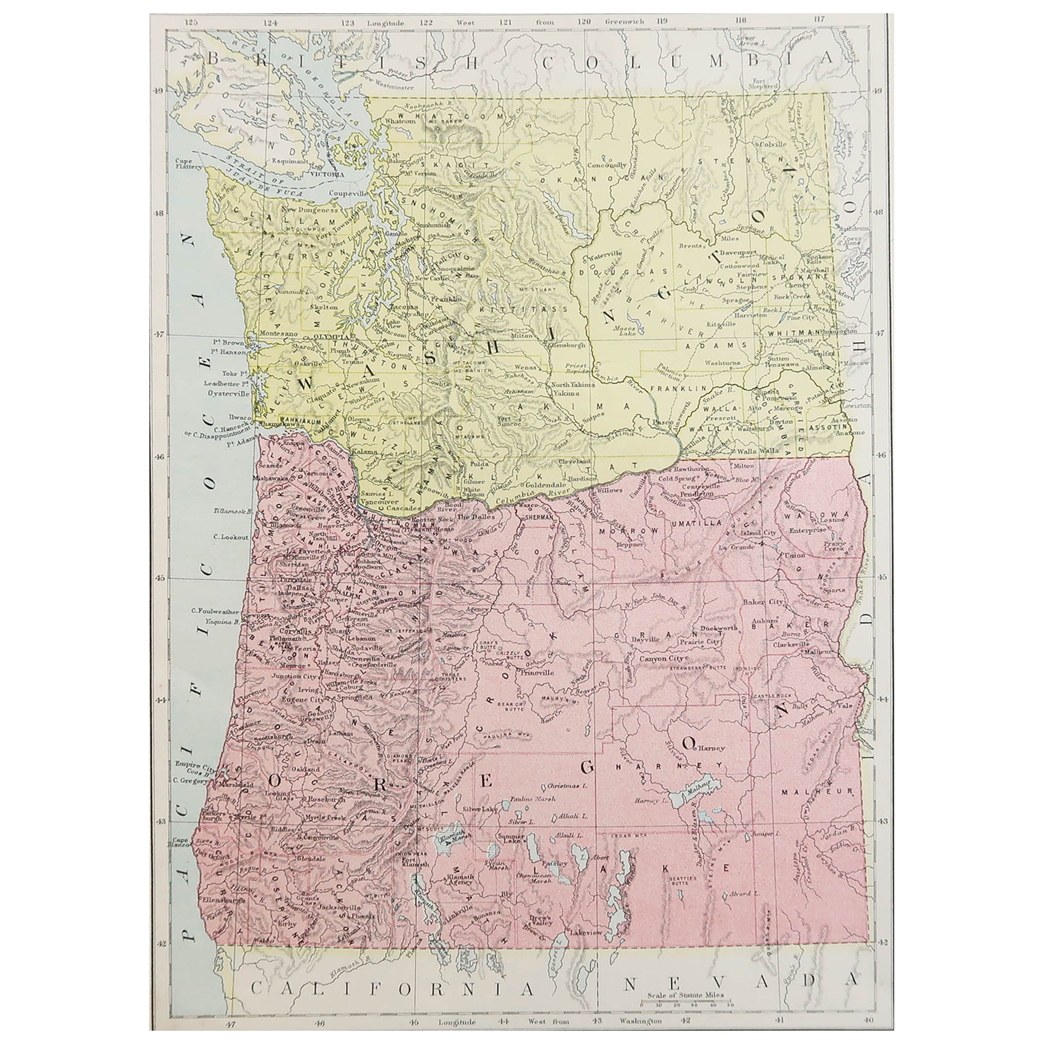
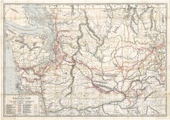
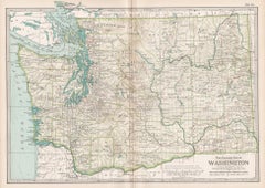
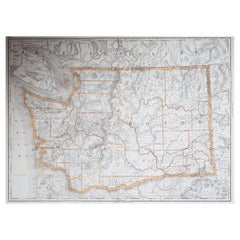
Antique Map of Washington – Railroads, Counties
Indian Reservations, 1888
This original engraved map shows the Territory of Washington in 1888, a historically important moment just one year before it achieved statehood in 1889. Produced by Rand, McNally
Co. in Chicago for their 'Improved Indexed Business Atlas and Shippers Guide', the map presents a detailed snapshot of the Pacific Northwest in the late 19th century, highlighting railroads, counties, settlements, and Native American reservations.
The map is rich in geographic and cultural detail. Railroads are marked in red and blue, including the Northern Pacific line crossing the state through Spokane, Yakima, and Tacoma, and other regional lines that connected towns to major ports. These railroads were crucial for linking Washington’s lumber, coal, and agricultural industries with markets across the United States. Important towns and cities such as Seattle, Tacoma, Olympia (the capital), Spokane Falls, and Walla Walla are clearly labeled, alongside smaller frontier communities that would later grow into significant population centers.
Equally notable are the Native American reservations prominently marked, including the Yakima Indian Reservation, Colville Indian Reservation, and smaller tribal lands, which reflect the contested history of settlement and displacement in the region. The map also delineates natural features such as the Cascade Range, Mount Rainier (then often called Mount Tacoma), the Columbia River, Puget Sound, and the Pacific coast, providing a sense of the dramatic landscapes that shaped Washington’s development. Vancouver Island and British Columbia are shown at the northern border, emphasizing the importance of cross-border trade and relations with Canada.
The timing of this map makes it particularly significant. In 1888, Washington Territory was experiencing rapid population growth and economic expansion, fueled by immigration, the timber trade, mining, and farming. Maps like this were used not only for travel and shipping but also for promoting land settlement and investment opportunities.
This piece was printed using engraving techniques, ensuring precise and durable detail, typical of Rand McNally’s highly regarded atlas productions.
Condition summary: Good condition for its age. Some light toning and faint foxing along the margins, original center fold as issued, and a small ink spot in the left margin not affecting the printed area. Paper remains strong and the plate impression is clear.
Framing tips: A dark wood or walnut frame will bring out the antique character of the map, while a black frame with a soft ivory or cream mat will provide a clean contrast. A double mount with a darker secondary tone, such as forest green or deep blue, can complement the depiction of rivers, coastlines, and the Pacific Ocean.
Technique: Engraving
Maker: Rand, McNally
Co., Chicago, 1888
---
- Dimensions:Height: 14.18 in (36 cm)Width: 20.67 in (52.5 cm)Depth: 0.01 in (0.2 mm)
- Materials and Techniques:Paper,Engraved
- Place of Origin:
- Period:
- Date of Manufacture:1888
- Condition:Condition summary: Good condition for its age. Some light toning and faint foxing along the margins, original center fold as issued, and a small ink spot in the left margin not affecting the printed area. Paper remains strong and the plate impression.
- Seller Location:Langweer, NL
- Reference Number:Seller: BG-12794-621stDibs: LU3054346342282
About the Seller
5.0
Recognized Seller
These prestigious sellers are industry leaders and represent the highest echelon for item quality and design.
Platinum Seller
Premium sellers with a 4.7+ rating and 24-hour response times
Established in 2009
1stDibs seller since 2017
2,830 sales on 1stDibs
Typical response time: 1 hour
- ShippingRetrieving quote...Shipping from: Langweer, Netherlands
- Return Policy
More From This Seller
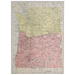
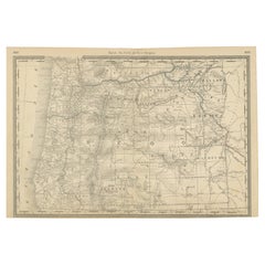
View All1888 Antique Map of Oregon – Railroads, Counties
Native Indian Reservations
Located in Langweer, NL
Antique Map of Oregon – Railroads, Indian Reservations & Counties, 1888
This antique engraved map presents the state of Oregon in 1888, a time when the Pacific Northwest was rapidly...
Category
Antique Late 19th Century American Maps
Materials
Paper
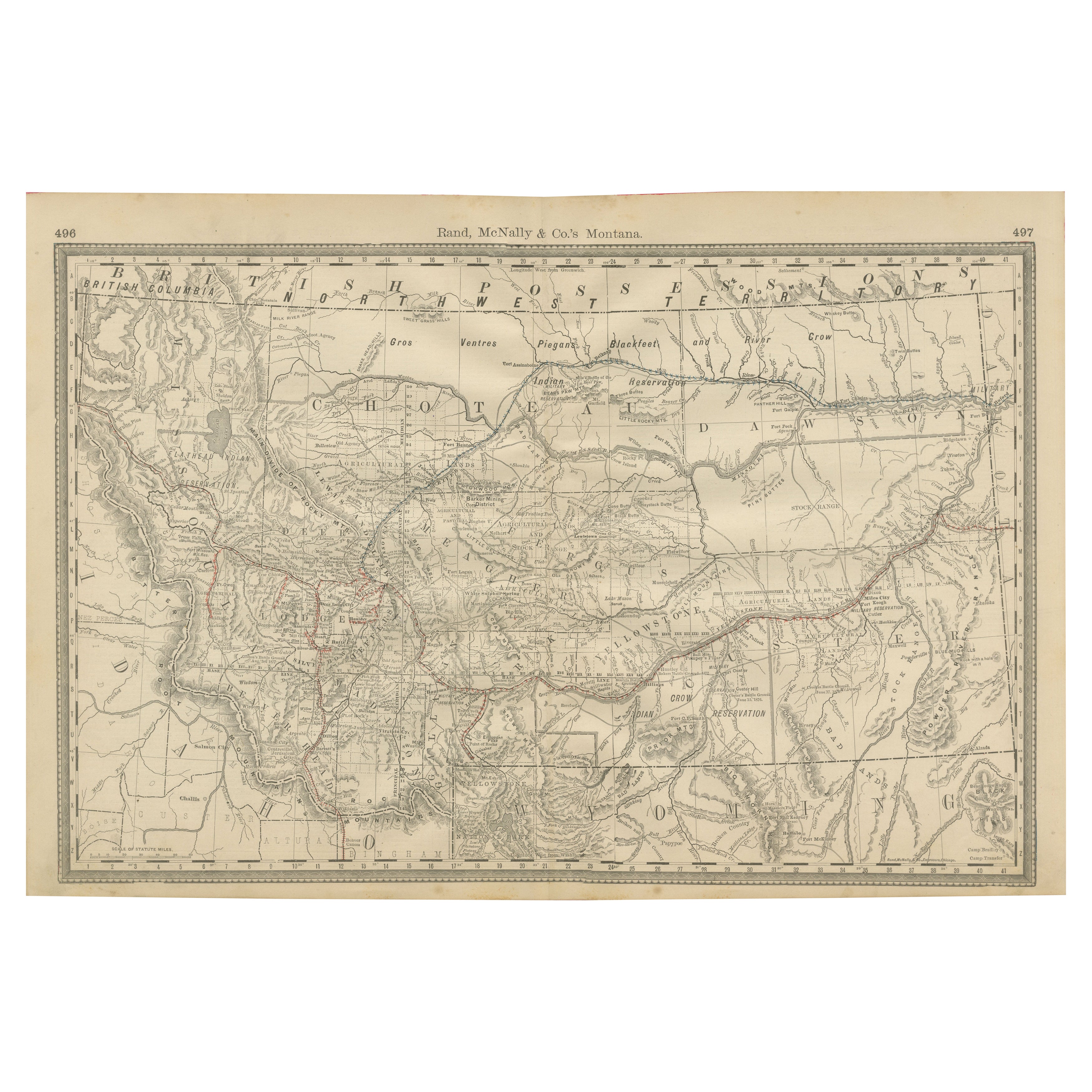
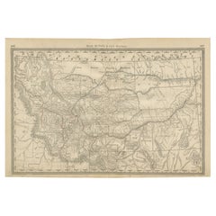
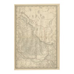
Old Map of Montana – Railroads, Indian Reservations
Frontier Settlements 1888
Located in Langweer, NL
Antique Map of Montana – Railroads, Indian Reservations & Frontier Settlements, 1888
This antique engraved map depicts the Territory of Montana in 1888, engraved and published by Ra...
Category
Antique Late 19th Century American Maps
Materials
Paper
Map of Western United States 1903 – Railroads, State Borders, and Terrain
Located in Langweer, NL
Map of Western United States 1903 – Railroads, State Borders, and Terrain
This beautifully engraved map titled "United States of North America (Western Sheet)" was created by Keith ...
Category
Early 20th Century Maps
Materials
Paper

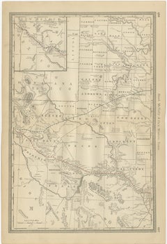
1888 Idaho Map – The Gem State’s Railroads, Mining Camps
Counties
Located in Langweer, NL
Antique Map of Idaho – Railroads, Mining Camps & Counties, 1888
This antique engraved map depicts the Territory of Idaho in 1888, engraved and published by Rand, McNally & Co. in Ch...
Category
Antique Late 19th Century American Maps
Materials
Paper
Western Texas Antique Map 1888 – Railroads, Counties
Frontier Towns
Located in Langweer, NL
Western Texas Map 1888 – Rand McNally Antique Lithograph
This antique 1888 map of Western Texas, published by Rand, McNally & Co., depicts the vast frontier counties of the region a...
Category
Antique Late 19th Century American Maps
Materials
Paper
1874 Map of Western United States – Detailed Atlas by Keith Johnston
Located in Langweer, NL
1874 Map of Western United States by Keith Johnston – Detailed Atlas
This is an original antique map titled “United States of North America (Western States)” by Alexander Keith John...
Category
Antique 1870s Scottish Maps
Materials
Paper

You May Also Like
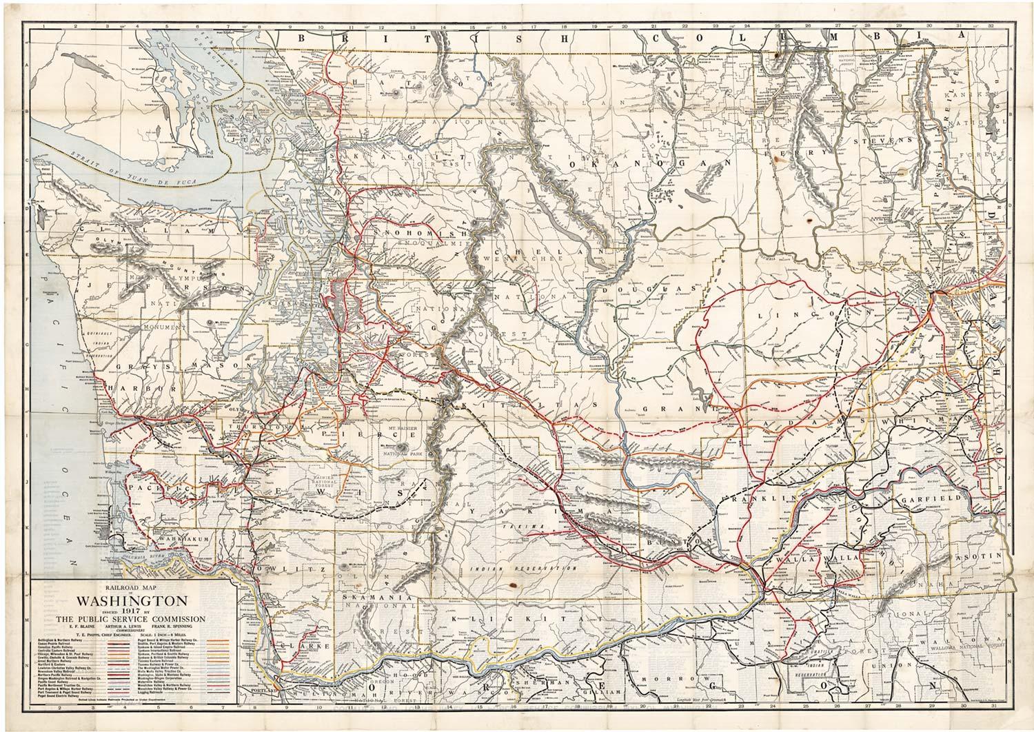
Original 1917 Railroad Map of Washington State railway map
Located in Spokane, WA
This is an Original Lithograph Vintage Railroad Map of Washington State; it is not a reproduction.
“Railroad Map of Washington, 1917, The Public Servi...
Category
1910s Academic Landscape Prints
Materials
Lithograph
$680 Sale Price
20% Off
Original Antique Map of the American State of Washington, 1903
Located in St Annes, Lancashire
Antique map of Washington
Published By A & C Black. 1903
Original colour
Good condition
Unframed.
Free shipping
Category
Antique Early 1900s English Maps
Materials
Paper

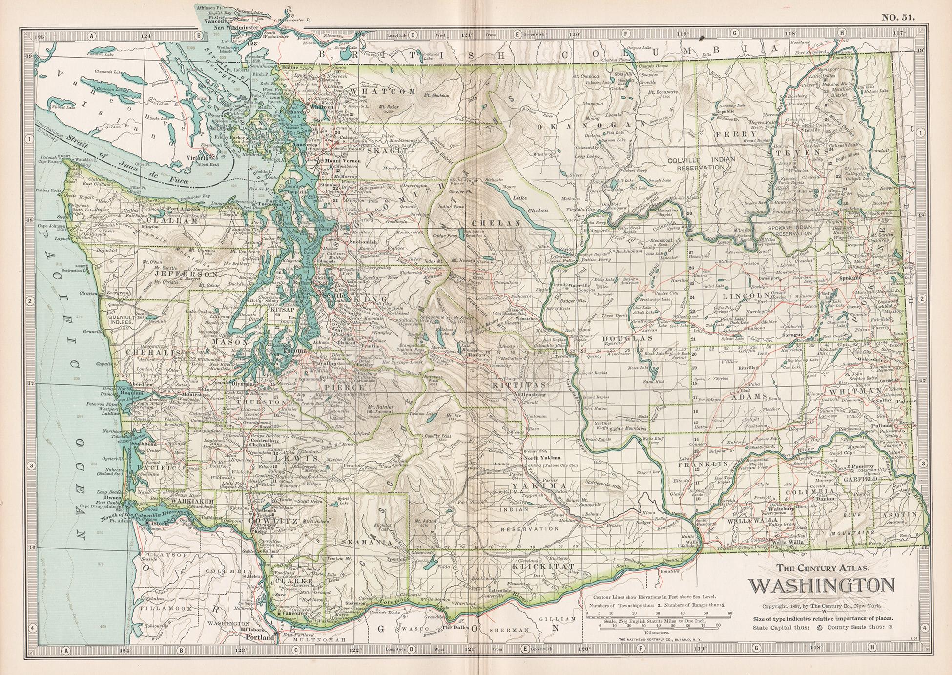
Washington. USA. Century Atlas state antique vintage map
Located in Melbourne, Victoria
'The Century Atlas. Washington'
Original antique map, 1903.
Central fold as issued. Map name and number printed on the reverse corners.
Sheet 29.5cm by 40cm.
Category
Early 20th Century Victorian More Prints
Materials
Lithograph
Original Antique Map of the American State of Washington, 1889
Located in St Annes, Lancashire
Great map of Washington
Drawn and Engraved by W. & A.K. Johnston
Published By A & C Black, Edinburgh.
Original colour
Unframed.
Category
Antique 1880s Scottish Victorian Maps
Materials
Paper

Large Original Antique Map of The State of Washington, USA, 1894
By Rand McNally
Co.
Located in St Annes, Lancashire
Fabulous map of Washington.
Original color.
By Rand, McNally & Co.
Published, 1894.
Unframed.
Free shipping.
Category
Antique 1890s American Maps
Materials
Paper
Original Antique Map of the American State of Oregon, 1889
Located in St Annes, Lancashire
Great map of Oregon
Drawn and Engraved by W. & A.K. Johnston
Published By A & C Black, Edinburgh.
Original colour
Unframed.
Category
Antique 1880s Scottish Victorian Maps
Materials
Paper