Items Similar to West Virginia Antique Railroad Map c.1888 – Mountain State Counties
Towns

Video Loading
Want more images or videos?
Request additional images or videos from the seller
1 of 12
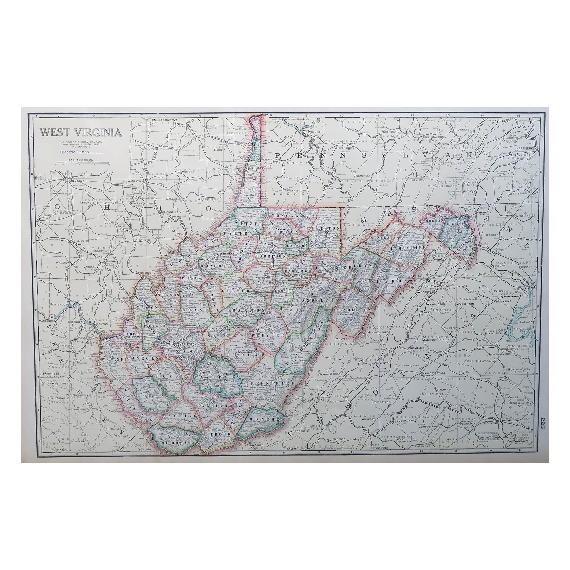
West Virginia Antique Railroad Map c.1888 – Mountain State Counties
Towns
$552.46
£409.23
€460
CA$755.90
A$822.48
CHF 435.49
MX$9,894.99
NOK 5,529.79
SEK 5,059.37
DKK 3,505.58
About the Item
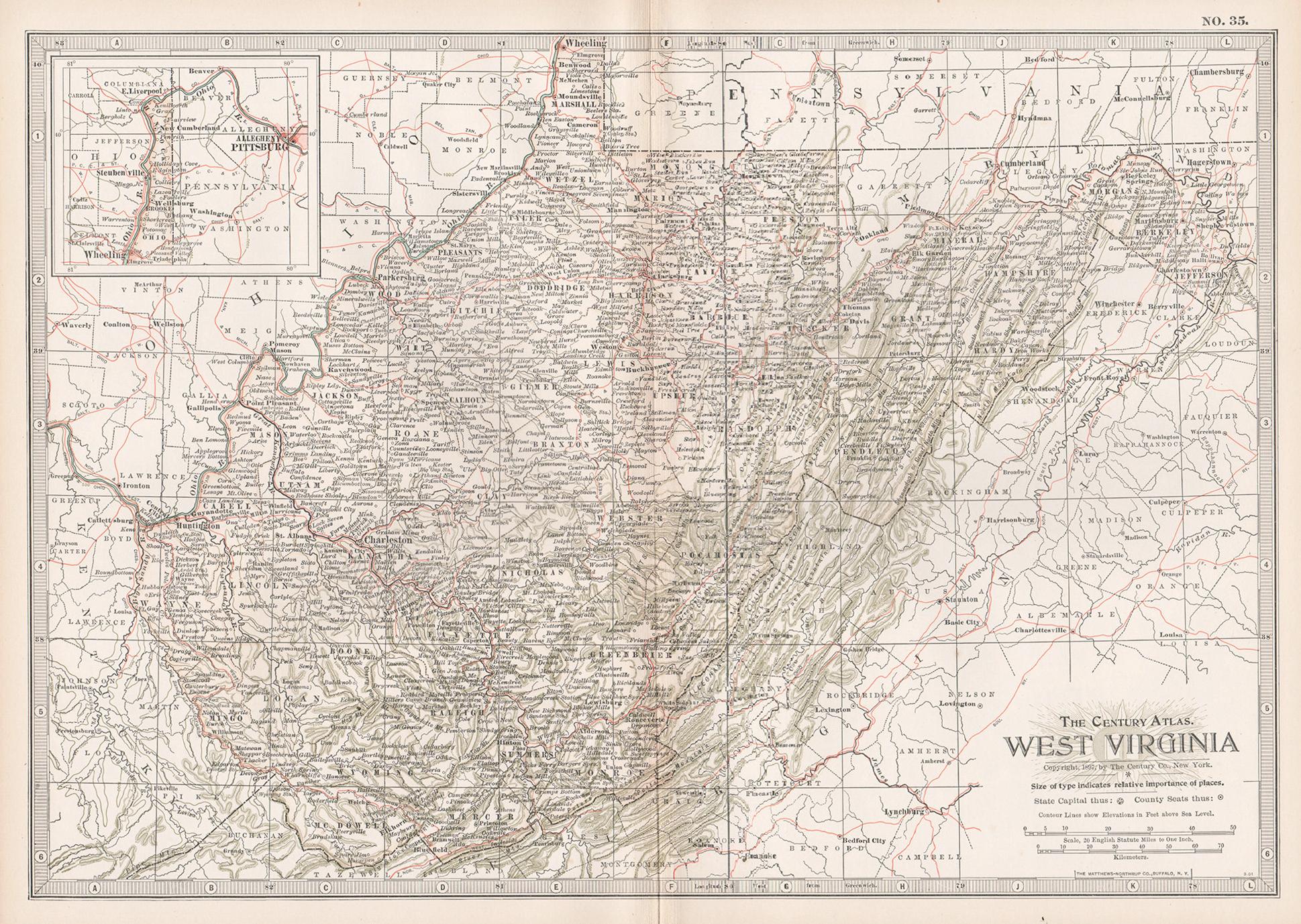
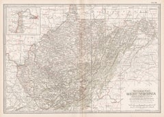
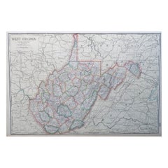
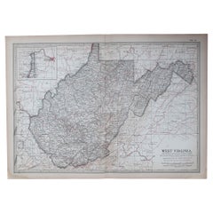
Antique Map of West Virginia – Rand McNally, circa 1888
This antique map of West Virginia was published by Rand, McNally
Co. around 1888. It offers a detailed late 19th-century view of the Mountain State, highlighting its rugged topography, county divisions, towns, and expanding railroad network.
The map clearly depicts the Allegheny Mountains and Appalachian ridges running across the eastern part of the state, engraved with striking clarity. Major towns and cities are shown, including Charleston, Wheeling, Parkersburg, Huntington, and Martinsburg, alongside countless smaller settlements. An inset at lower right provides additional detail of the northern panhandle region along the Ohio River, an area of growing industrial importance in the late 1800s.
Railroads, shown in red and blue, form the backbone of the map, weaving through valleys and linking mining areas to trade routes. The network reflects West Virginia’s crucial role as a coal-producing state during the industrial boom of the Gilded Age. Rivers such as the Ohio, Kanawha, and Monongahela are also carefully drawn, emphasizing the state’s natural transport corridors.
This map illustrates West Virginia in a pivotal period of its history, capturing both its distinctive geography and the economic forces that were reshaping it. Collectors of Appalachian history, American railroads, or state maps will find this a particularly appealing piece.
Condition report:
Good condition with mild age toning and light fold wear along the issued center crease. Clean margins with only minor handling marks. Plate mark visible. Strong impression with crisp engraved detail.
Framing tips:
A dark walnut or black frame with an ivory mat would highlight the engraved mountain ranges and rivers. A double mat with cream outer and muted green inner will emphasize the rugged Appalachian terrain and add depth to the presentation.
Technique: Lithograph with original outline color
Maker: Rand, McNally
Co., Chicago, circa 1888
- Dimensions:Height: 14.18 in (36 cm)Width: 20.67 in (52.5 cm)Depth: 0.01 in (0.2 mm)
- Materials and Techniques:Paper,Engraved
- Place of Origin:
- Period:
- Date of Manufacture:1888
- Condition:Good condition with mild age toning and light fold wear along the issued center crease. Clean margins with only minor handling marks. Plate mark visible. Strong impression with crisp engraved detail.
- Seller Location:Langweer, NL
- Reference Number:Seller: BG-12794-241stDibs: LU3054346430372
About the Seller
5.0
Recognized Seller
These prestigious sellers are industry leaders and represent the highest echelon for item quality and design.
Platinum Seller
Premium sellers with a 4.7+ rating and 24-hour response times
Established in 2009
1stDibs seller since 2017
2,816 sales on 1stDibs
Typical response time: 1 hour
- ShippingRetrieving quote...Shipping from: Langweer, Netherlands
- Return Policy
More From This Seller
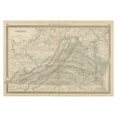
View AllAntique Virginia Map c.1888 – Railroads, Towns
The Old Dominion
Located in Langweer, NL
Antique Map of Virginia – Rand McNally, circa 1888
This antique map of Virginia was published by Rand, McNally & Co. around 1888. Drawn from one of their influential late 19th-centu...
Category
Antique Late 19th Century American Maps
Materials
Paper
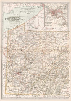
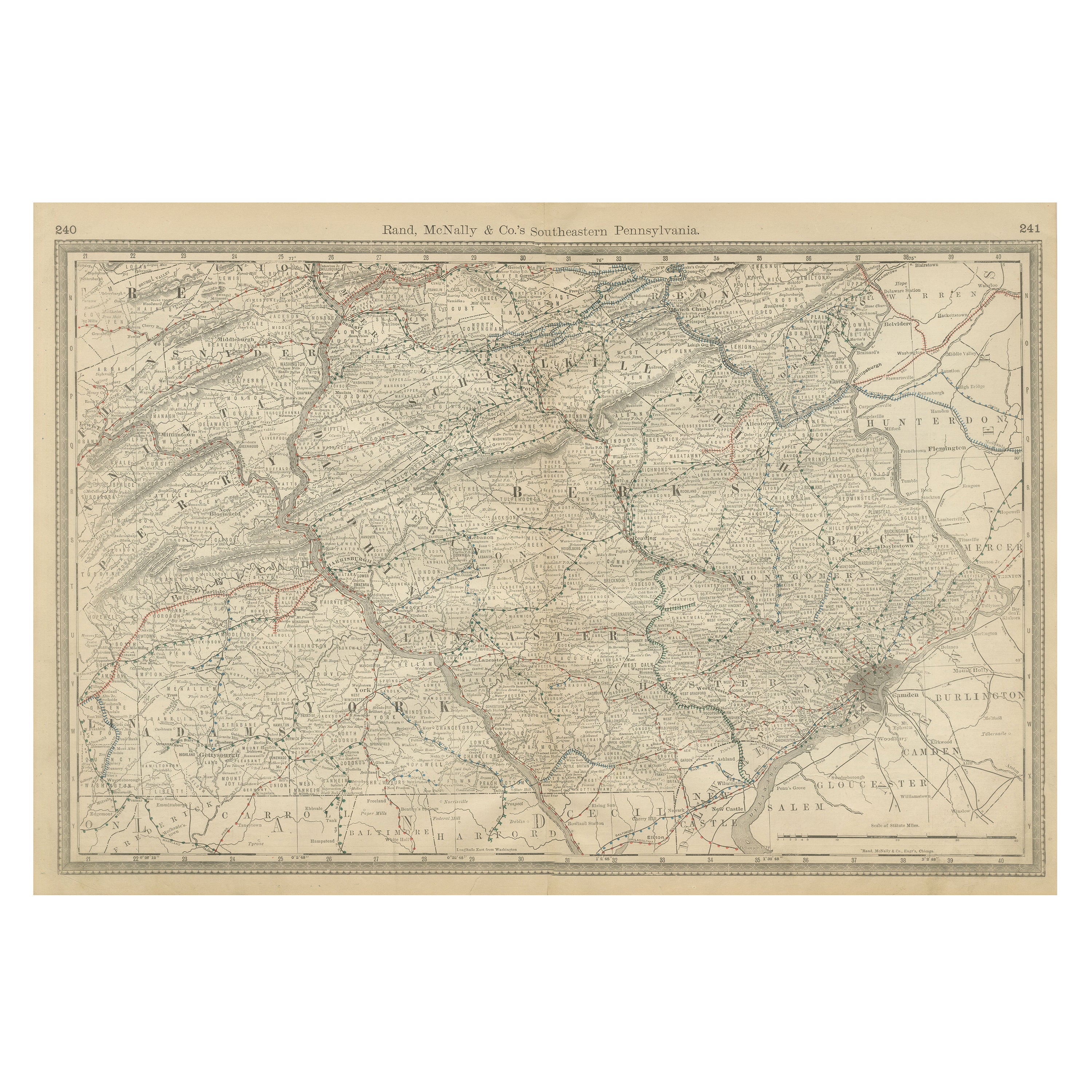
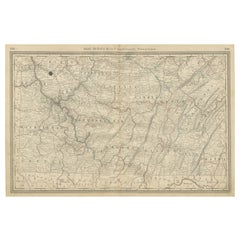
Pennsylvania 1888 Antique Map – The Keystone State, Southeastern Railroads
Located in Langweer, NL
Antique Map of Southeastern Pennsylvania – Rand McNally, circa 1888
This antique map of southeastern Pennsylvania was published by Rand, McNally & Co. around 1888, taken from one of...
Category
Antique Late 19th Century American Maps
Materials
Paper
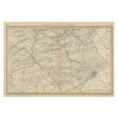
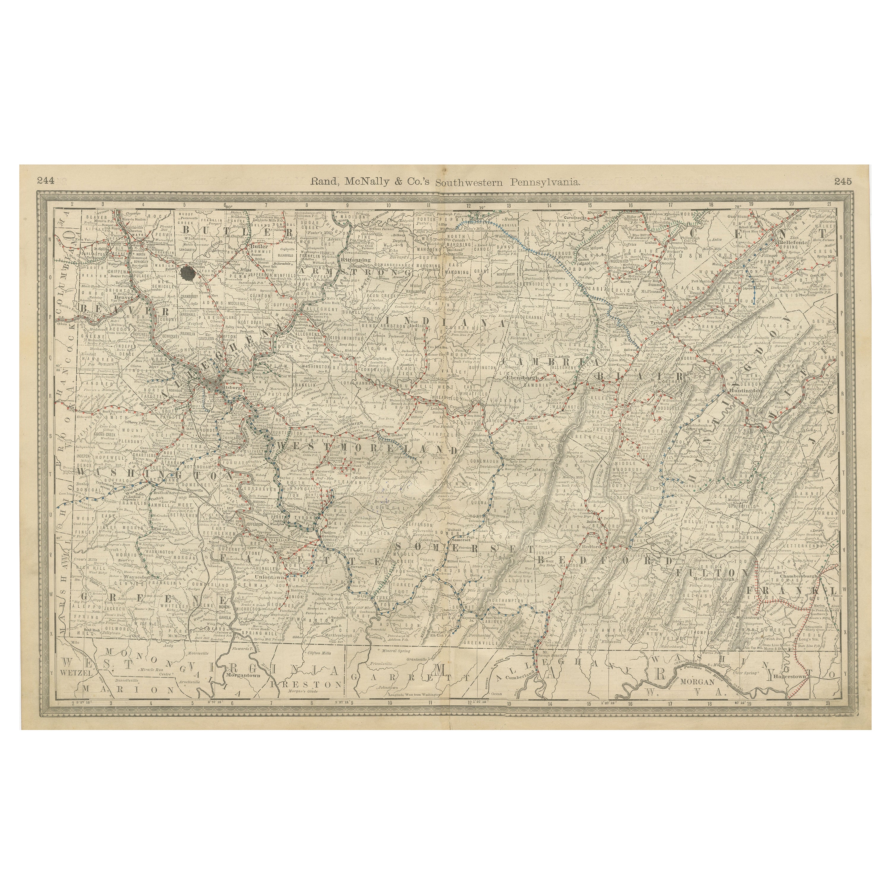
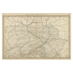
Southwestern Pennsylvania Antique Map c.1888 – Keystone State Counties
Cities
Located in Langweer, NL
Antique Map of Southwestern Pennsylvania – Rand McNally, circa 1888
This antique map of southwestern Pennsylvania was published by Rand, McNally & Co. around 1888. It comes from the...
Category
Antique Late 19th Century American Maps
Materials
Paper
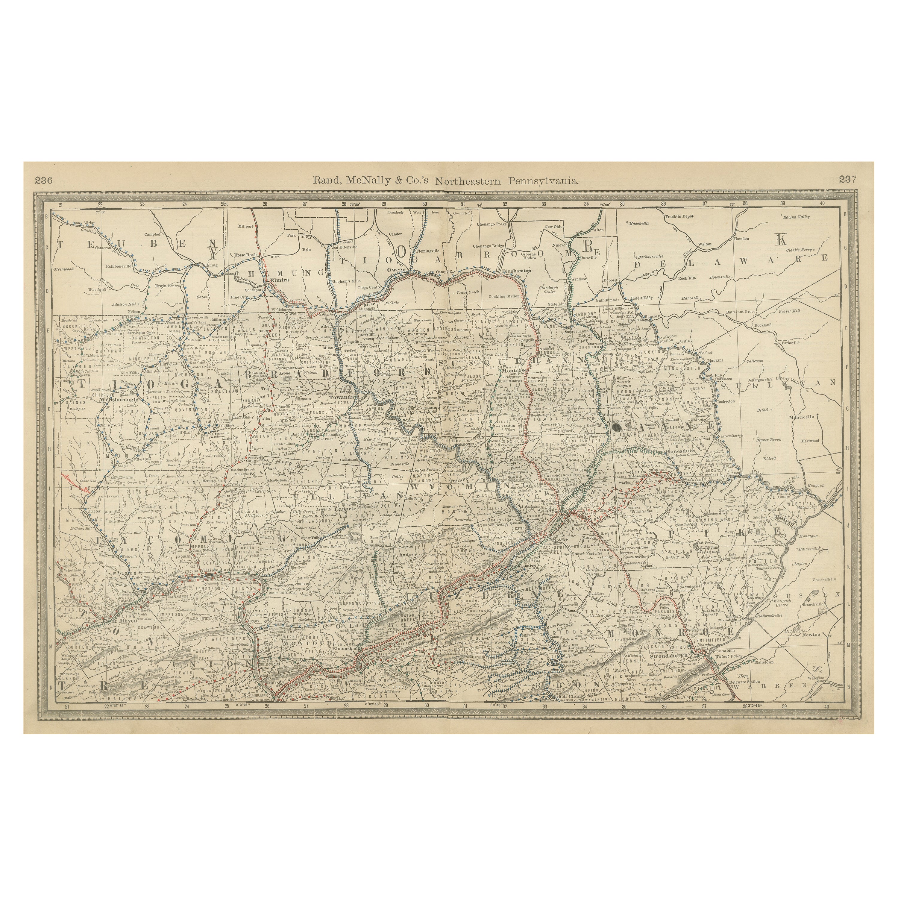
Northeastern Pennsylvania Antique Map c.1888 – Keystone State Cities
Counties
Located in Langweer, NL
Antique Map of Northeastern Pennsylvania – Rand McNally, circa 1888
This antique map of northeastern Pennsylvania was published by Rand, McNally & Co. around 1888. Taken from one of...
Category
Antique Late 19th Century American Maps
Materials
Paper
Antique Map of Virginia, with Inset Map of the Northern Part, 1888
Located in Langweer, NL
Antique map titled 'West Virginia'. Original antique map of Virginia, United States. With inset map of the 'Panhandle' or northern part of West...
Category
Antique Late 19th Century British Maps
Materials
Paper

$278 Sale Price
20% Off
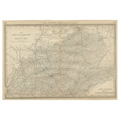
Antique Map of Kentucky
Tennessee – The Bluegrass
Volunteer States, 1888
Located in Langweer, NL
Antique Map of Kentucky & Tennessee – The Bluegrass & Volunteer States, 1888
This antique engraved map of Kentucky and Tennessee, published in 1888 by Rand, McNally & Co. in Chicago for their Improved Indexed Business Atlas and Shippers Guide, provides a highly detailed view of two historically important Southern states in the late 19th century. It shows counties, towns, and an extensive network of railroads, capturing a period when rail transportation was rapidly transforming the economy and society of the post-Civil War South.
The Kentucky section, titled “New County and Railroad Map of Kentucky,” highlights the state’s counties, with Louisville, Lexington, Covington, and Frankfort (the state capital) standing out as major centers. Known as “The Bluegrass State,” Kentucky was already famous for its fertile farmland, thoroughbred horse breeding, and bourbon whiskey industry. The map shows dense railroad coverage, including the Louisville & Nashville Railroad, which connected Kentucky to major markets in the Midwest and South.
The Tennessee portion, titled “County and Railroad Map of Tennessee,” provides similar detail. Counties such as Shelby, Davidson, Knox, and Hamilton are clearly marked, along with the major cities of Memphis, Nashville (the state capital), Knoxville, and Chattanooga. Known as “The Volunteer State,” Tennessee played a critical role in American history, from its frontier heritage to its importance during the Civil War. By 1888, Tennessee’s economy was diversifying, with Memphis as a cotton trading hub, Nashville as a growing cultural and commercial center, and Chattanooga as a key industrial city connected to the railroads.
The map’s railroad...
Category
Antique Late 19th Century American Maps
Materials
Paper
You May Also Like
West Virginia. USA. Century Atlas state antique vintage map
Located in Melbourne, Victoria
'The Century Atlas. West Virginia'
Original antique map, 1903.
Central fold as issued. Map name and number printed on the reverse corners.
Sheet 29.5cm by 40cm.
Category
Early 20th Century Victorian More Prints
Materials
Lithograph
Large Original Antique Map of West Virginia, USA, C.1900
Located in St Annes, Lancashire
Fabulous map of West Virginia
Original color
Engraved and printed by the George F. Cram Company, Indianapolis.
Published, C.1900
Unframed
Free shipping.
Category
Antique 1890s American Maps
Materials
Paper
Original Antique Map of the American State of Virginia, 1903
Located in St Annes, Lancashire
Antique map of West Virginia
Published By A & C Black. 1903
Original colour
Good condition
Unframed.
Free shipping
Category
Antique Early 1900s English Maps
Materials
Paper
Original Antique Map of the American State of Pennsylvania( Eastern Part ), 1903
Located in St Annes, Lancashire
Antique map of Pennsylvania ( Eastern part )
Published By A & C Black. 1903
Original colour
Good condition
Unframed.
Free shipping
Category
Antique Early 1900s English Maps
Materials
Paper

Pennsylvania, Eastern Part. USA. Century Atlas state antique vintage map
Located in Melbourne, Victoria
'The Century Atlas. Pennsylvania, Eastern Part.'
Original antique map, 1903.
Central fold as issued. Map name and number printed on the reverse corners.
Sheet 40cm by 29.5cm.
Category
Early 20th Century Victorian More Prints
Materials
Lithograph
Pennsylvania, Western Part. USA Century Atlas state antique vintage map
Located in Melbourne, Victoria
'The Century Atlas. Pennsylvania, Western Part'
Original antique map, 1903.
Central fold as issued. Map name and number printed on the reverse corners.
Sheet 40cm by 29.5cm.
Category
Early 20th Century Victorian More Prints
Materials
Lithograph