Items Similar to Western
Eastern Hemisphere Maps – World Double Hemisphere Engravings 1857


Video Loading
Want more images or videos?
Request additional images or videos from the seller
1 of 14
Western
Eastern Hemisphere Maps – World Double Hemisphere Engravings 1857
$576.91per set
£427.34per set
€480per set
CA$789.20per set
A$860.18per set
CHF 454.77per set
MX$10,354.97per set
NOK 5,772.18per set
SEK 5,291.91per set
DKK 3,657.33per set
About the Item
Western
Eastern Hemisphere Maps – World Double Hemisphere Engravings 1857
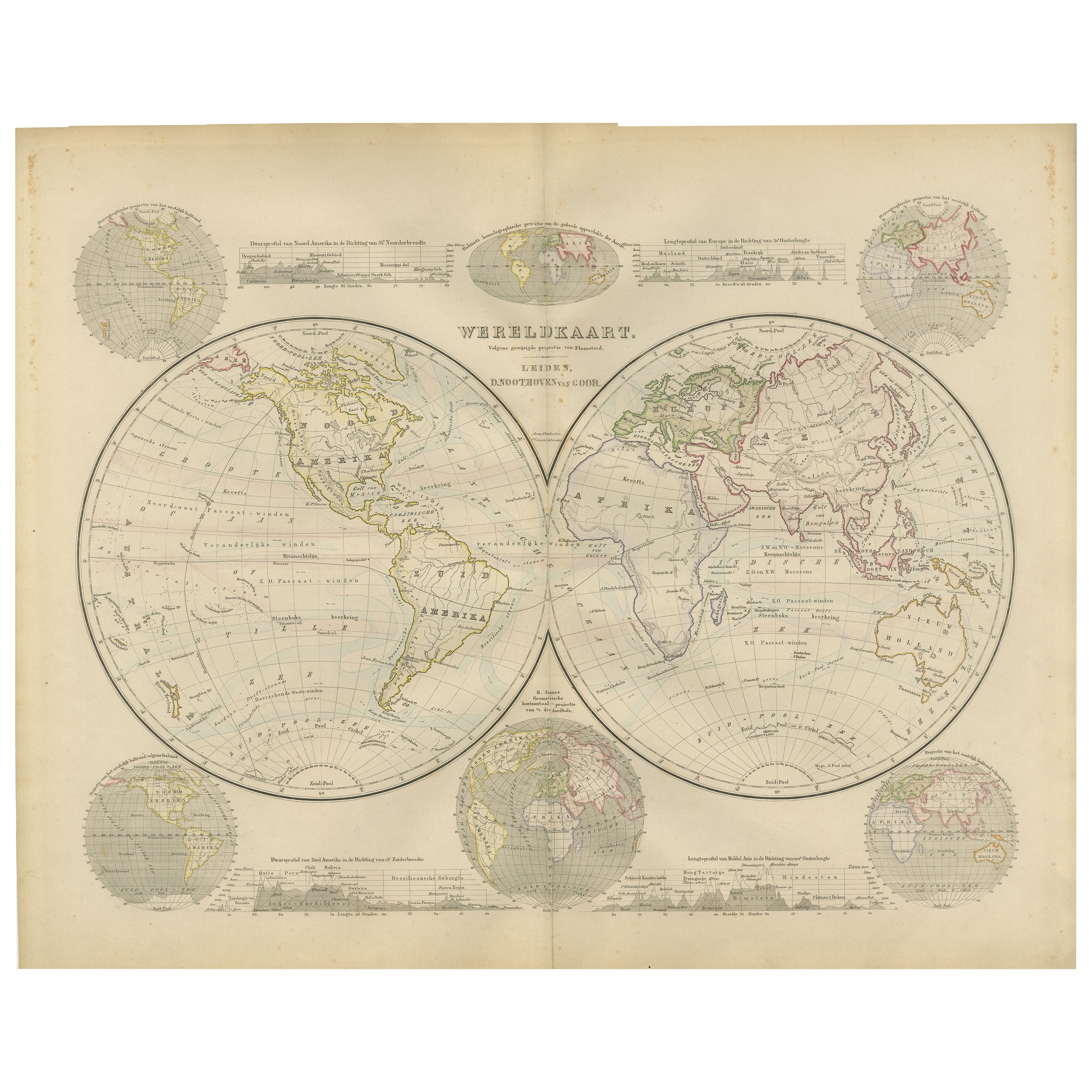
These beautiful antique prints show two complementary hemispheric maps titled “Westliche Halbkugel” (Western Hemisphere) and “Oestliche Halbkugel” (Eastern Hemisphere). The Western Hemisphere map presents North and South America in fine detail, including the United States, Mexico, Central America, the Caribbean islands, and South America down to Tierra del Fuego. It also includes Polynesia across the Pacific, with labelled island groups reflecting mid-19th-century geographical knowledge.
The Eastern Hemisphere map depicts Europe, Asia, Africa, and Australia with clarity, showing political boundaries as they were recognised in 1857. Notable features include detailed coastlines, major rivers and mountain ranges, the delineation of colonial territories in Africa, and the extent of Russia across Siberia. Australia is labelled with its colonial divisions, and Southeast Asia is clearly defined, reflecting European perspectives of the time.
Both maps were engraved and published in 1857 in Gotha by Justus Perthes as part of Adolf Stieler’s famous Hand-Atlas. Stieler’s atlases were renowned for their accuracy, clarity, and elegance, used widely by scholars and travellers throughout the 19th century.
Technique: Copperplate engraving with original outline hand colouring used to differentiate national boundaries and enhance readability. The engraving is finely executed with German titles and notations, and each hemisphere is presented in a clean circular projection.
These maps are significant as they represent mid-19th-century cartography at its finest, capturing geopolitical realities before major events such as German unification or the Scramble for Africa reshaped borders.
Condition summary: Both maps are in excellent condition with minimal age toning, no tears or repairs, and strong, crisp impressions. Colours remain fresh and paper is firm throughout.
Framing tips: Frame these maps as a matching pair in identical dark wood or ebonised frames to create a powerful decorative display. Use wide ivory or cream mounts to provide a clean margin around each hemisphere. UV-protective glass is recommended to preserve colours and fine engraved detail for long-term enjoyment.
- Dimensions:Height: 14.77 in (37.5 cm)Width: 17.88 in (45.4 cm)Depth: 0.01 in (0.2 mm)
- Sold As:Set of 2
- Materials and Techniques:Paper,Engraved
- Place of Origin:
- Period:
- Date of Manufacture:1857
- Condition:Condition summary: Both maps are in excellent condition with minimal age toning, no tears or repairs, and strong, crisp impressions. Colours remain fresh and paper is firm throughout.
- Seller Location:Langweer, NL
- Reference Number:Seller: BG-05552-5, -61stDibs: LU3054345809042
About the Seller
5.0
Recognized Seller
These prestigious sellers are industry leaders and represent the highest echelon for item quality and design.
Platinum Seller
Premium sellers with a 4.7+ rating and 24-hour response times
Established in 2009
1stDibs seller since 2017
2,811 sales on 1stDibs
Typical response time: 1 hour
- ShippingRetrieving quote...Shipping from: Langweer, Netherlands
- Return Policy
More From This Seller
View AllAntique Map of The World in Hemispheres by W. G. Blackie, 1859
Located in Langweer, NL
Antique map titled 'The World in Hemispheres with other projections'. Original antique map of The World. This map originates from ‘The Imperial Atlas of Modern Geography’. Published ...
Category
Antique Mid-19th Century Maps
Materials
Paper

$294 Sale Price
30% Off
Antique Map of the World in two sheets, 1852
Located in Langweer, NL
Antique map titled 'The World on Mercator's Projection'. Two individual sheets of the world. This map originates from 'Lowry's table Atlas constructed and engraved from the most rece...
Category
Antique Mid-19th Century Maps
Materials
Paper

$240 Sale Price / set
20% Off
Double Hemisphere World Map from the Nieuwe Hand-Atlas, Leiden 1876
Located in Langweer, NL
Title: Double Hemisphere World Map from the Nieuwe Hand-Atlas, Leiden 1876
Description:
This 19th-century double-hemisphere world map, titled “Wereldkaart volgens gewone projectie v...
Category
Antique 1870s Dutch Maps
Materials
Paper
Antique Map of the Eastern Hemisphere by Wyld, 1842
Located in Langweer, NL
Antique map titled 'Eastern Hemisphere'. Large map depicting the continents Europe, Asia, Afrika and Australia.
Artists and Engravers: James Wyld (1812–1887) was a British geograph...
Category
Antique 19th Century Maps
Materials
Paper

Antique Map of The World in Hemispheres on Various Projections, 1882
Located in Langweer, NL
This stunning 1882 'Antique Map of The World in Hemispheres' showcases an exquisite blend of cartographic precision and artistic elegance. Crafted under the watchful eye of W.G. Blac...
Category
Antique 1880s Maps
Materials
Paper

$269 Sale Price
20% Off
Antique Map of the World in Hemispheres by Johnson,
1872
Located in Langweer, NL
Antique map titled 'Johnson's Globular World. Original world map depicting the Eastern Hemisphere and the Western Hemisphere. This map originates fr...
Category
Antique Late 19th Century Maps
Materials
Paper

You May Also Like
Original Antique Map of The World by Thomas Clerk, 1817
Located in St Annes, Lancashire
Great map of The Eastern and Western Hemispheres
On 2 sheets
Copper-plate engraving
Drawn and engraved by Thomas Clerk, Edinburgh.
Published by Mackenzie And Dent, 1817
...
Category
Antique 1810s English Maps
Materials
Paper

Original Antique Map of The Eastern Hemisphere by Dower, circa 1835
Located in St Annes, Lancashire
Nice map of the Eastern Hemisphere
Drawn and engraved by J.Dower
Published by Orr & Smith. C.1835
Unframed.
Free shipping
Category
Antique 1830s English Maps
Materials
Paper

Original Antique Map of The World by Dower, circa 1835
Located in St Annes, Lancashire
Nice map of the World
Drawn and engraved by J.Dower
Published by Orr & Smith. C.1835
Unframed.
Free shipping
Category
Antique 1830s English Maps
Materials
Paper

Original Antique Map of The Western Hemisphere by Dower, circa 1835
Located in St Annes, Lancashire
Nice map of the Western Hemisphere
Drawn and engraved by J.Dower
Published by Orr & Smith. C.1835
Unframed.
Free shipping
Category
Antique 1830s English Maps
Materials
Paper

1864 Original illustrated planisphere - World Map - Geography
Located in PARIS, FR
Immerse yourself in the epic journey of the past with the Illustrated Historical Planisphere of 1864 by Charpentier! 🗺️ This cartographic treasure transports you through the intrica...
Category
1860s Prints and Multiples
Materials
Linen, Paper, Lithograph

Antique Map of Eastern Hemisphere from the collection of Thierry Despont
Located in New York, NY
Designed by Enrico Bonetti (E. Bonatti) and published by Francesco Vallardi Editore. Based on an earlier map by Evangelista Azzi (Ev. Azzi). Labeled as such at bottom edge of map.
T...
Category
Antique Late 19th Century Italian Maps
Materials
Canvas, Wood

More Ways To Browse
German Engraving
Africa Colonial
China Silk Rug
Chrome Glass Coffee Tables
Antique Italian Chairs
Beni Ourain Rugs
French Iron And Glass Table
Glass Top Wood Base Coffee Tables
T Chair
Antique Silver Basket
Antique Walkers
Ebony Wood Furniture
Opalescent Glass
Pair Of Danish Chairs
Veneer Dining Tables
1970 Italian Armchair
Furniture Uk
House Of Denmark Table And Chairs