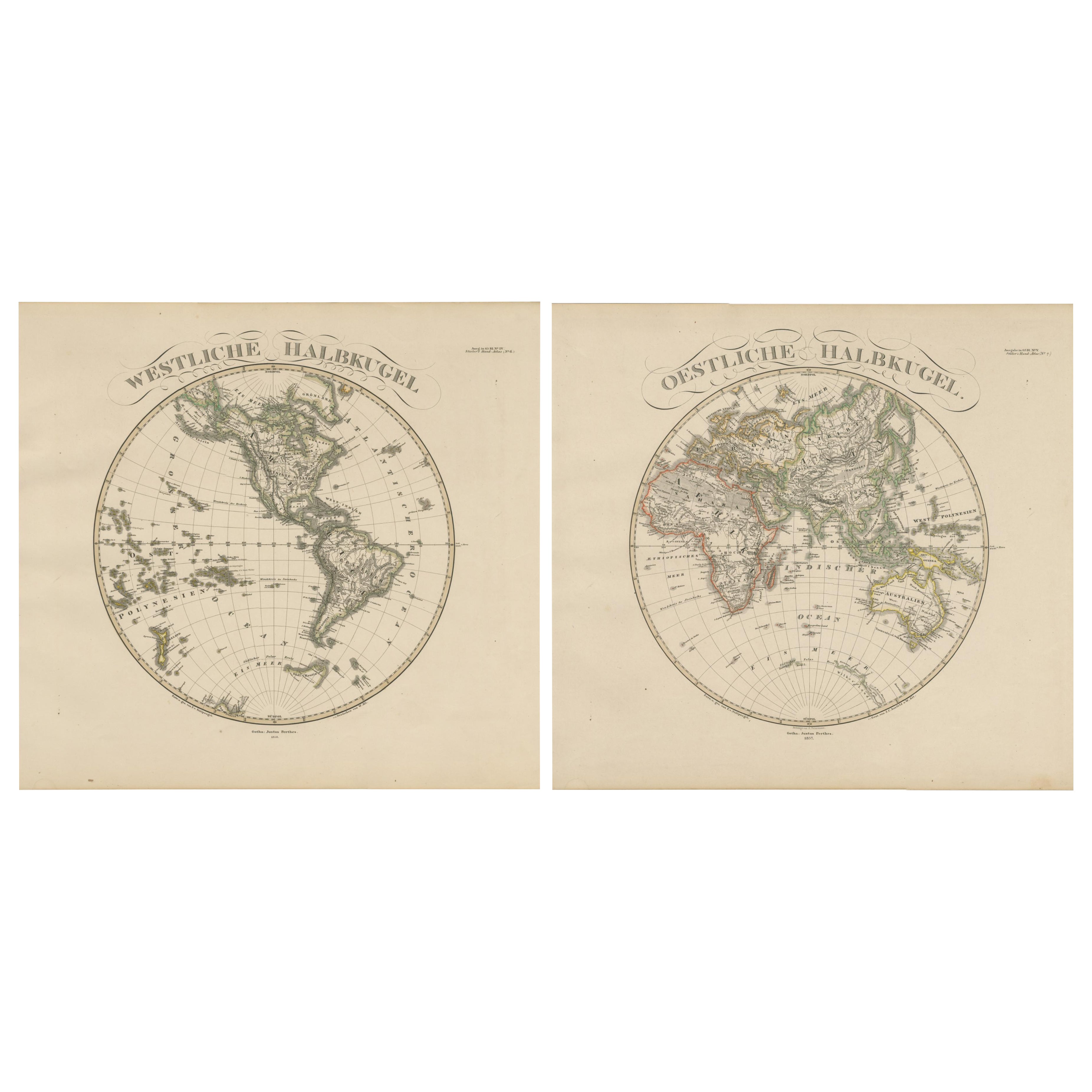
Items Similar to Western Hemisphere - 1876 Edition by Adolf Stieler, Published by Justus Perthes


Want more images or videos?
Request additional images or videos from the seller
1 of 6
Western Hemisphere - 1876 Edition by Adolf Stieler, Published by Justus Perthes
$227.86
$284.8320% Off
£169.97
£212.4620% Off
€192
€24020% Off
CA$317.15
CA$396.4420% Off
A$340.24
A$425.3120% Off
CHF 182.50
CHF 228.1320% Off
MX$4,096.50
MX$5,120.6220% Off
NOK 2,300.63
NOK 2,875.7820% Off
SEK 2,097.85
SEK 2,622.3220% Off
DKK 1,463.19
DKK 1,828.9820% Off
About the Item
Map titled "Westliche Halbkugel" (Western Hemisphere), is a copperplate engraving from 1876 by Adolf Stieler, a renowned German cartographer. Here's an expanded analysis based on the image and its description:
1. Cartographic Detail:
- The map is extremely detailed, depicting the Western Hemisphere with precision. The boundaries between nations and political entities are delineated using vibrant hand-applied color washes, which was common for high-quality maps of the time.
- Geographical features such as mountains, swamps, passes, islands, and bodies of water are carefully labeled. This level of detail is characteristic of Stieler's work, particularly in the 1870s when his *Hand Atlas* became one of the most detailed and accurate atlases available.
2. Mapmaker's Signature:
- The map is signed by *Gotha Justus Perthes*, one of the most prestigious German cartographic publishing firms. Established by Johan Georg Justus Perthes, the firm became a leader in European cartography. The Perthes family business was responsible for producing some of the finest maps and atlases of the 19th century.
- Adolf Stieler was one of the key figures in this firm, known for his precise and detailed work.
3. Map Features:
- The map focuses on the Western Hemisphere, showcasing the Americas, as well as parts of the Pacific Ocean and nearby islands (Polynesia is labeled, for example).
- The labels are in German, reflecting the map’s origin.
- The map likely includes geographical information like relative ocean depths and underwater features, which were an innovative inclusion in Stieler's works.
4. Condition and Quality:
- The description notes that the map is in very good condition.
- Stieler’s maps were known for being printed on high-quality paper with deep platemarks, indicating the care taken in their production.
5. Historical Context:
- This map reflects a period of intense interest in geography and exploration in Europe. By the 1870s, much of the Americas had been mapped in detail, and maps like this would have been used for educational and reference purposes by scholars, explorers, and possibly governments.
- The map is a snapshot of geopolitical boundaries as they were understood at the time, with the clear delineation of national borders.
This map, part of the legacy of one of the greatest cartographic publishing firms of the 19th century, is an excellent example of the craftsmanship and scientific rigor of its time. It would be highly valued by collectors of antique maps, especially those with an interest in the detailed and historically significant works of the Justus Perthes firm.
- Dimensions:Height: 14.97 in (38 cm)Width: 18.12 in (46 cm)Depth: 0 in (0.02 mm)
- Materials and Techniques:
- Period:
- Date of Manufacture:1876
- Condition:Very good condition. Blank on verso. Small tear in top and light browning around the edges, far from the image. Study the scans carefully.
- Seller Location:Langweer, NL
- Reference Number:Seller: BG-13290-81stDibs: LU3054341476682
About the Seller
5.0
Recognized Seller
These prestigious sellers are industry leaders and represent the highest echelon for item quality and design.
Platinum Seller
Premium sellers with a 4.7+ rating and 24-hour response times
Established in 2009
1stDibs seller since 2017
2,830 sales on 1stDibs
Typical response time: 1 hour
- ShippingRetrieving quote...Shipping from: Langweer, Netherlands
- Return Policy
More From This Seller
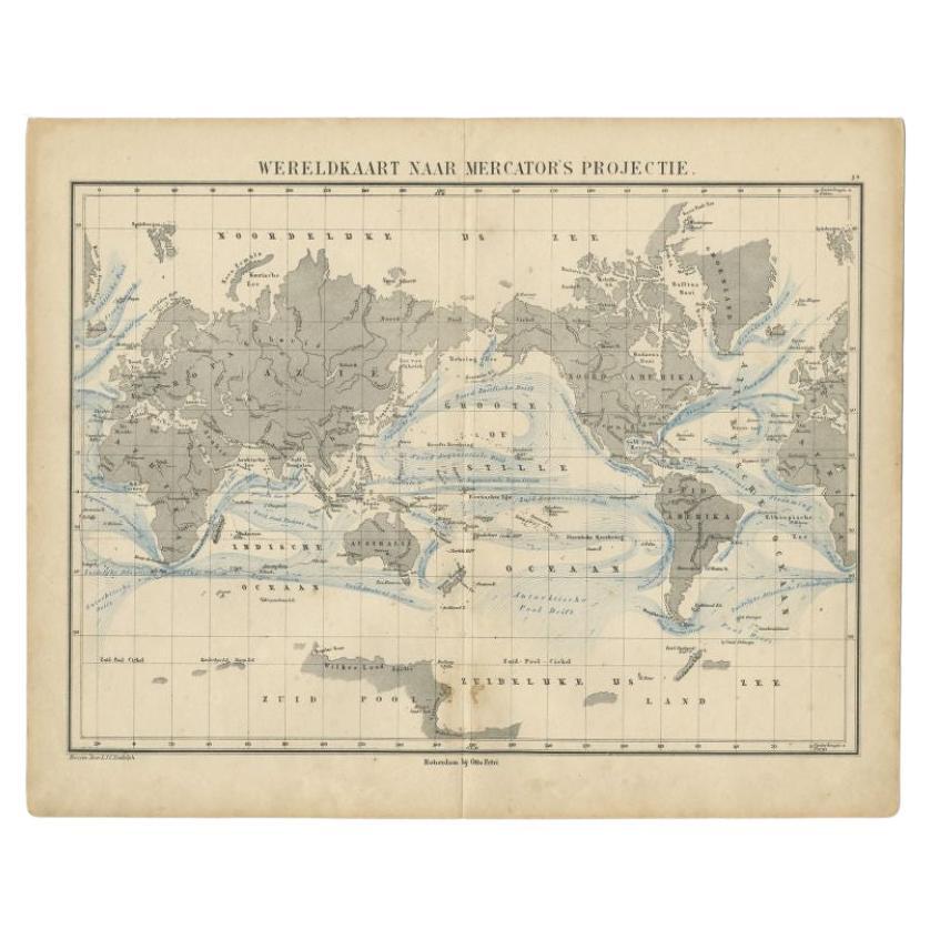
View AllAntique Mercator Projection World Map by Petri, c.1873
Located in Langweer, NL
Antique world map titled 'Wereldkaart naar Mercator's Projectie'. Old map of the world. This map originates from 'School-Atlas van alle Deelen der Aarde'.
Artists and engravers: ...
Category
Antique 19th Century Maps
Materials
Paper

Western
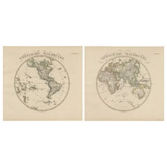
Eastern Hemisphere Maps – World Double Hemisphere Engravings 1857
Located in Langweer, NL
Western & Eastern Hemisphere Maps – World Double Hemisphere Engravings 1857
These beautiful antique prints show two complementary hemispheric maps titled “Westliche Halbkugel” (West...
Category
Antique Mid-19th Century German Maps
Materials
Paper
Antique Map of the Western Hemisphere by Wyld
1845
Located in Langweer, NL
Antique map titled 'Western Hemisphere'. Original antique map of the western hemisphere. This map originates from 'An Atlas of the World, Comprehending Separate Maps of its...
Category
Antique Mid-19th Century Maps
Materials
Paper

$332 Sale Price
20% Off
Antique Map of the World by A. Vuillemin, 1854
By Victor Levasseur
Located in Langweer, NL
This map originates from ‘Atlas National de la France Illustré’. Published by A. Combette, Paris, 1854.
Category
Antique Mid-19th Century Maps
Materials
Paper

$333 Sale Price
25% Off
Antique Map of the World in Hemispheres by Johnson,
1872
Located in Langweer, NL
Antique map titled 'Johnson's Globular World. Original world map depicting the Eastern Hemisphere and the Western Hemisphere. This map originates fr...
Category
Antique Late 19th Century Maps
Materials
Paper

Antique Map of The World in Hemispheres by W. G. Blackie, 1859
Located in Langweer, NL
Antique map titled 'The World in Hemispheres with other projections'. Original antique map of The World. This map originates from ‘The Imperial Atlas of Modern Geography’. Published ...
Category
Antique Mid-19th Century Maps
Materials
Paper

$290 Sale Price
30% Off
You May Also Like
1864 Original illustrated planisphere - World Map - Geography
Located in PARIS, FR
Immerse yourself in the epic journey of the past with the Illustrated Historical Planisphere of 1864 by Charpentier! 🗺️ This cartographic treasure transports you through the intrica...
Category
1860s Prints and Multiples
Materials
Linen, Paper, Lithograph

Original Antique Map of The Western Hemisphere by Dower, circa 1835
Located in St Annes, Lancashire
Nice map of the Western Hemisphere
Drawn and engraved by J.Dower
Published by Orr & Smith. C.1835
Unframed.
Free shipping
Category
Antique 1830s English Maps
Materials
Paper

Original Antique Map of The World by Thomas Clerk, 1817
Located in St Annes, Lancashire
Great map of The Eastern and Western Hemispheres
On 2 sheets
Copper-plate engraving
Drawn and engraved by Thomas Clerk, Edinburgh.
Published by Mackenzie And Dent, 1817
...
Category
Antique 1810s English Maps
Materials
Paper

Original Antique Map of The World by Dower, circa 1835
Located in St Annes, Lancashire
Nice map of the World
Drawn and engraved by J.Dower
Published by Orr & Smith. C.1835
Unframed.
Free shipping
Category
Antique 1830s English Maps
Materials
Paper

Antique Map of Eastern Hemisphere from the collection of Thierry Despont
Located in New York, NY
Designed by Enrico Bonetti (E. Bonatti) and published by Francesco Vallardi Editore. Based on an earlier map by Evangelista Azzi (Ev. Azzi). Labeled as such at bottom edge of map.
T...
Category
Antique Late 19th Century Italian Maps
Materials
Canvas, Wood

Large Original Antique Map of The World, Fullarton, C.1870
Located in St Annes, Lancashire
Great map of the World. Showing both hemispheres
From the celebrated Royal Illustrated Atlas
Lithograph. Original color.
Published by Fullarton, Edinburgh, C.1870
Unframed.
Rep...
Category
Antique 1870s Scottish Maps
Materials
Paper

More Ways To Browse
18th Century Engravings
Antique Carved Wood Chair
Black Scandinavian Modern Dining Chairs
Dutch Mid Century Modern Table
Gold Modern Coffee Table
Iconic Modern Furniture
Midcentury Modern Gray Glass Vase
Round Glass Coffee Tables
Vintage Cave
18th Century Wood Side Tables
Antique Hand Carved Dining Room Sets
Mid Century Modern Pitcher
Vintage Italian Leather Dining Chair
Vintage Movie Posters
Blue Green Wool And Silk Rug
Brown Sheepskin Chair
Vintage Brass Bar Carts
Antique Botanical Prints