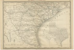
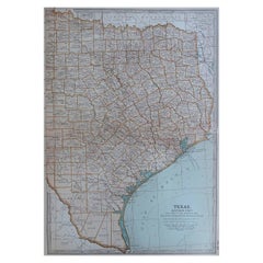
Items Similar to Western Texas Antique Map 1888 – Railroads, Counties
Frontier Towns
Want more images or videos?
Request additional images or videos from the seller
1 of 10
Western Texas Antique Map 1888 – Railroads, Counties
Frontier Towns
$646.83
£483.68
€540
CA$891.17
A$971.95
CHF 514.87
MX$11,652.29
NOK 6,557.19
SEK 5,996.07
DKK 4,115.02
About the Item
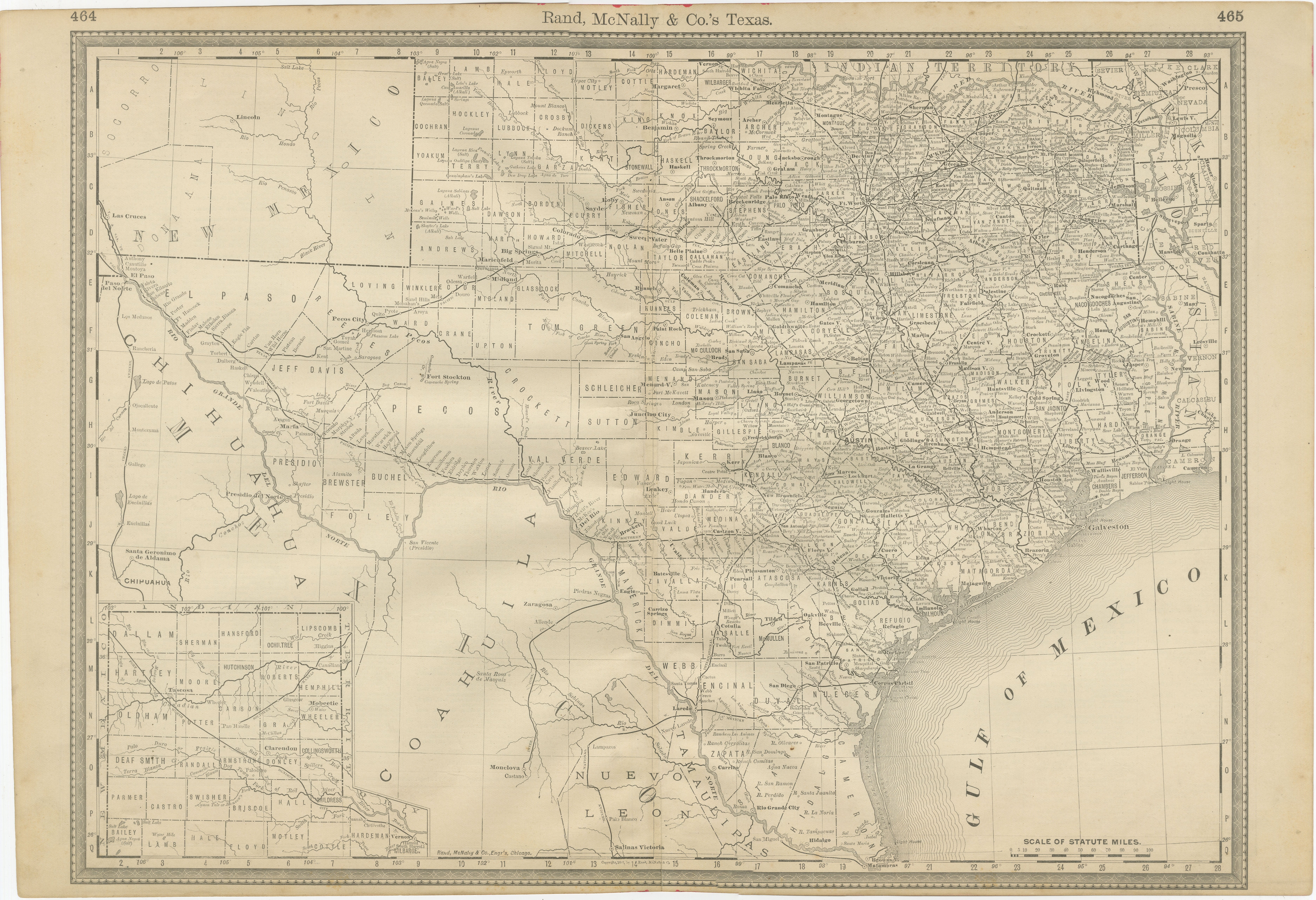
Western Texas Map 1888 – Rand McNally Antique Lithograph
This antique 1888 map of Western Texas, published by Rand, McNally
Co., depicts the vast frontier counties of the region at a time when much of this land was still sparsely settled. Unlike the more densely populated eastern portion of Texas, western Texas remained rugged, with dramatic landscapes, military outposts, and scattered ranching communities marking the edge of American expansion.
The map covers the area from Tom Green, Crockett, and Howard Counties westward through Pecos, Reeves, Jeff Davis, Presidio, and Brewster Counties, reaching the Rio Grande along the Mexican border. Neighboring Mexico is clearly marked, as are key border towns such as Presidio del Norte and Ciudad Juárez (then Paso del Norte). An inset at the upper left provides further detail of northwestern New Mexico, highlighting rail connections extending toward Santa Fe.
Topography is given special attention, with the Davis Mountains, Guadalupe Mountains, and numerous buttes, mesas, and canyons engraved in fine detail. Rivers such as the Pecos and Rio Grande are prominently featured, winding through otherwise arid country. The map also shows forts and military posts—including Fort Stockton, Fort Davis, and Fort Bliss—underscoring the continued U.S. Army presence in maintaining order and protecting settlers during this period.
Railroads are drawn in red and blue lines, showing the advance of rail infrastructure into the region. The Southern Pacific line through El Paso, extending eastward toward San Antonio, is a notable feature, connecting this frontier with the national railroad network and providing vital links for trade, cattle, and migration.
This map is historically important for its portrayal of Texas’s western counties at a time before they were heavily developed. Vast tracts of land are labeled simply with county names, emphasizing the scale and emptiness of the frontier. Today, many of these areas have become part of Texas’s cultural and economic identity, known for oil, ranching, and desert landscapes.
For collectors of Texas history, western expansion, or frontier cartography, this map offers an invaluable glimpse into a region still in transition from frontier to settled state.
Condition: Good, with light toning and foxing in the margins and folding line. Plate mark visible. Minor age-related edge wear, but paper remains strong and clean with no tears.
Framing tips: A strong walnut or black frame with a cream mat is recommended to emphasize the rugged detail of the engraving. A secondary mat in earthy tones (tan or rust red) would further complement the western subject matter.
Technique: Lithograph with printed detail
Maker: Rand, McNally
Co., Chicago, 1888
- Dimensions:Height: 20.67 in (52.5 cm)Width: 14.18 in (36 cm)Depth: 0.01 in (0.2 mm)
- Materials and Techniques:Paper,Engraved
- Place of Origin:
- Period:
- Date of Manufacture:1888
- Condition:Condition: Good, with light toning and foxing in the margins and folding line. Plate mark visible. Minor age-related edge wear, but paper remains strong and clean with no tears.
- Seller Location:Langweer, NL
- Reference Number:Seller: BG-12794-481stDibs: LU3054346391192
About the Seller
5.0
Recognized Seller
These prestigious sellers are industry leaders and represent the highest echelon for item quality and design.
Platinum Seller
Premium sellers with a 4.7+ rating and 24-hour response times
Established in 2009
1stDibs seller since 2017
2,791 sales on 1stDibs
Typical response time: <1 hour
- ShippingRetrieving quote...Shipping from: Langweer, Netherlands
- Return Policy
More From This Seller
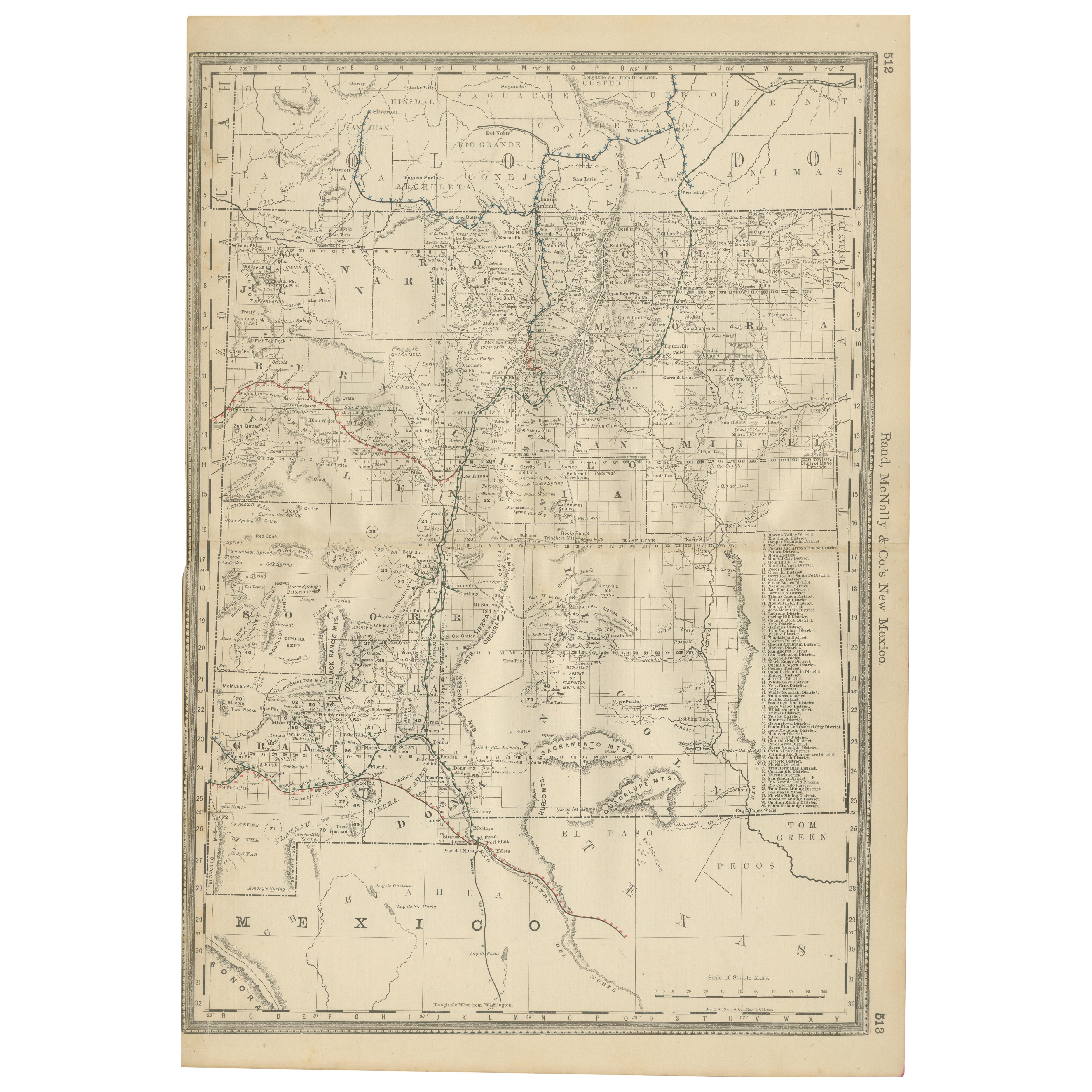
View All1888 New Mexico Map – Railroads, Counties
The Land of Enchantment
Located in Langweer, NL
Antique Map of New Mexico – Railroads, Counties & Frontier Settlements, 1888
This antique engraved map depicts the Territory of New Mexico in 1888, engraved and published by Rand, M...
Category
Antique Late 19th Century American Maps
Materials
Paper

Texas Antique Map 1888 – Railroads, Counties
Frontier Settlements
Located in Langweer, NL
Texas Railroad Map 1888 – Rand McNally Antique Lithograph
This antique 1888 map of Texas, published by Rand, McNally & Co., provides a detailed overview of the state during a critic...
Category
Antique Late 19th Century American Maps
Materials
Paper

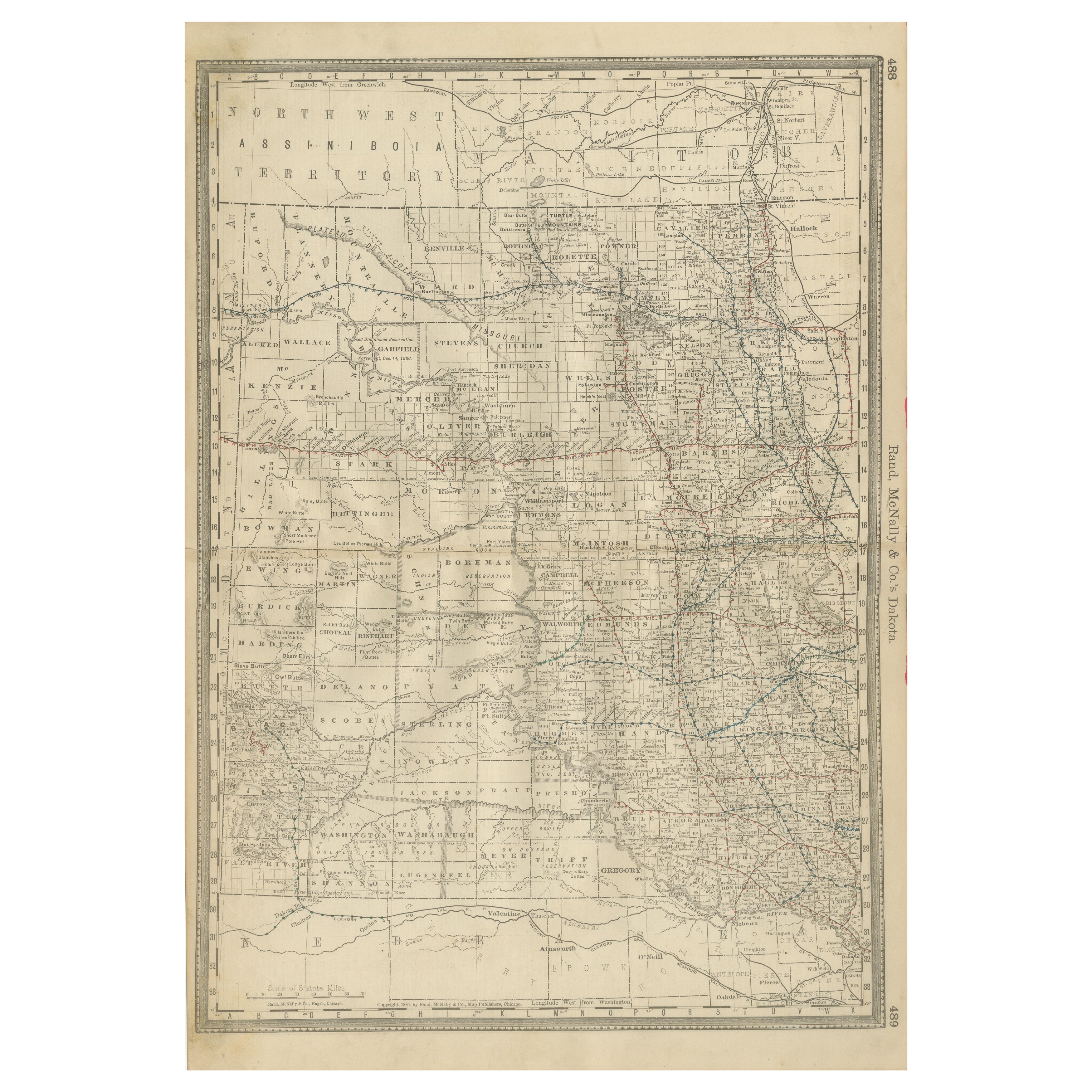
Dakota Territory Railroad Map 1888 – Rand McNally Antique Lithograph
Located in Langweer, NL
Antique Map of Dakota Territory – Rand McNally Railroad Map, 1888
This detailed 1888 map of Dakota by Rand, McNally & Co. captures the region in the final year before its division i...
Category
Antique Late 19th Century American Maps
Materials
Paper
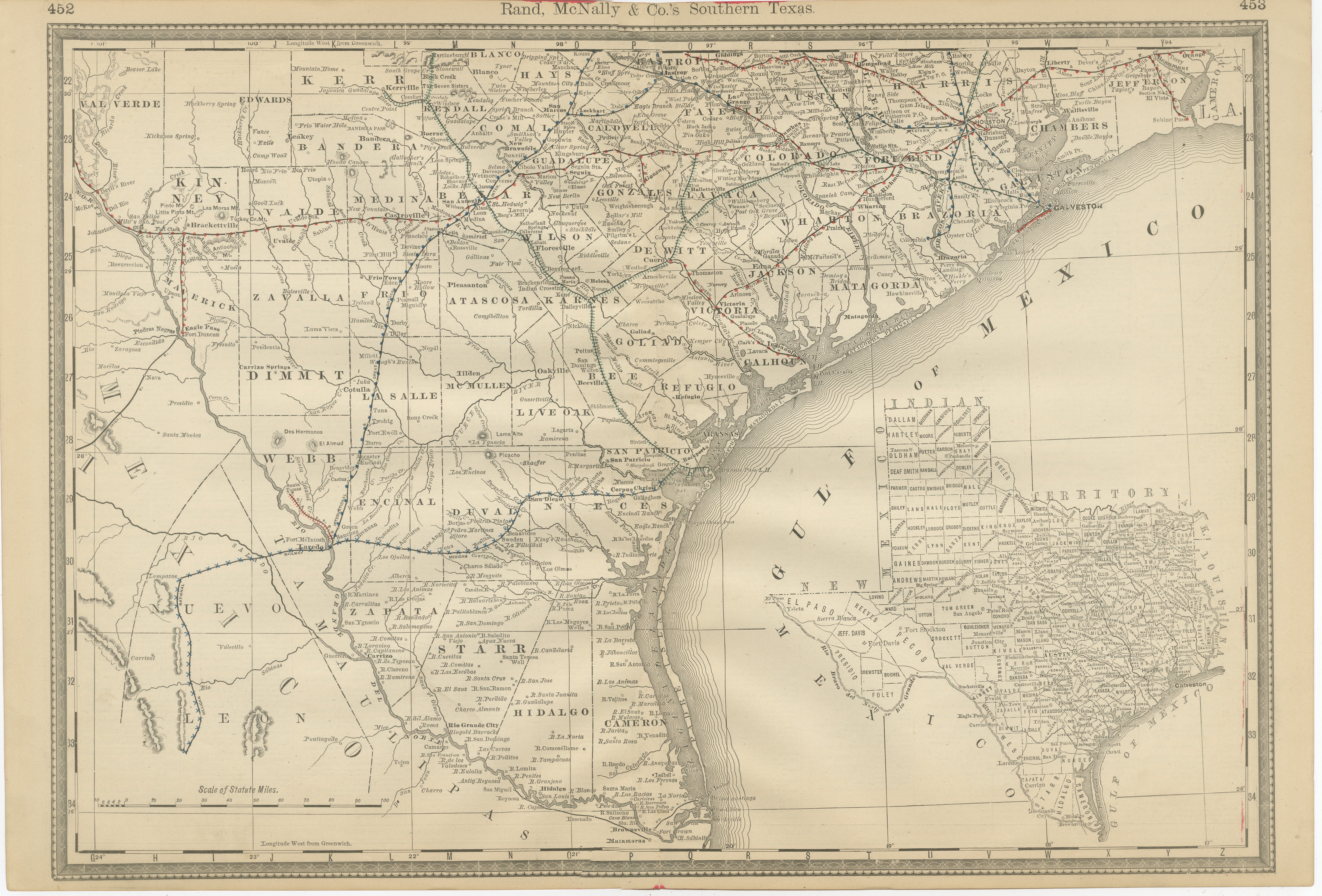
Antique Map 1888 – Southern Texas Railroads, Counties
Settlements
Located in Langweer, NL
Southern Texas Map 1888 – Rand McNally Antique Lithograph
This antique 1888 map of Southern Texas, published by Rand, McNally & Co., depicts the Gulf Coast and borderlands with Mexi...
Category
Antique Late 19th Century American Maps
Materials
Paper
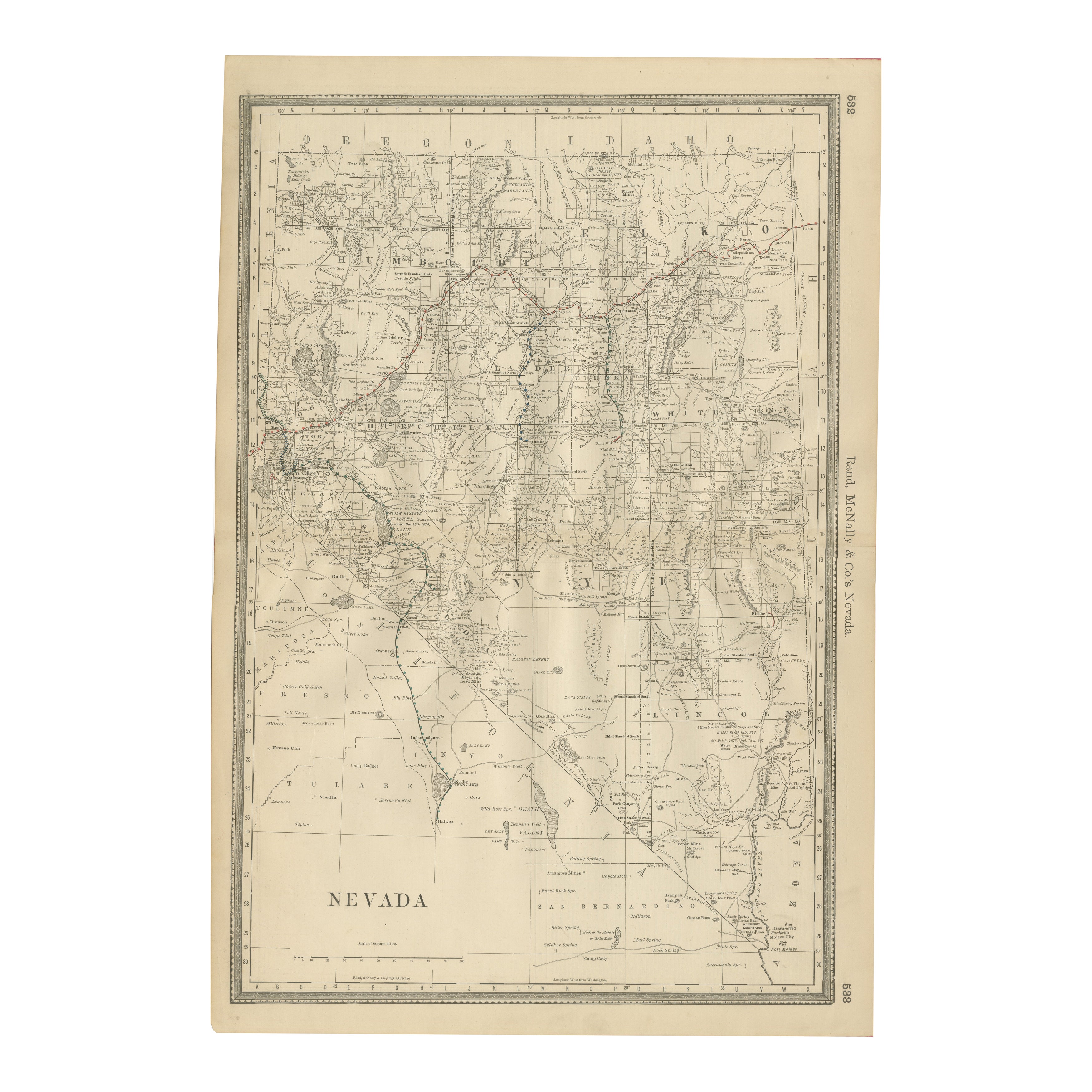
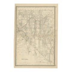
Antique Map of Nevada – Railroads, Mining Camps
Counties, 1888
Located in Langweer, NL
Antique Map of Nevada – Railroads, Mining Camps & Counties, 1888
This antique engraved map depicts the state of Nevada in 1888, engraved and published by Rand, McNally & Co. in Chic...
Category
Antique Late 19th Century American Maps
Materials
Paper
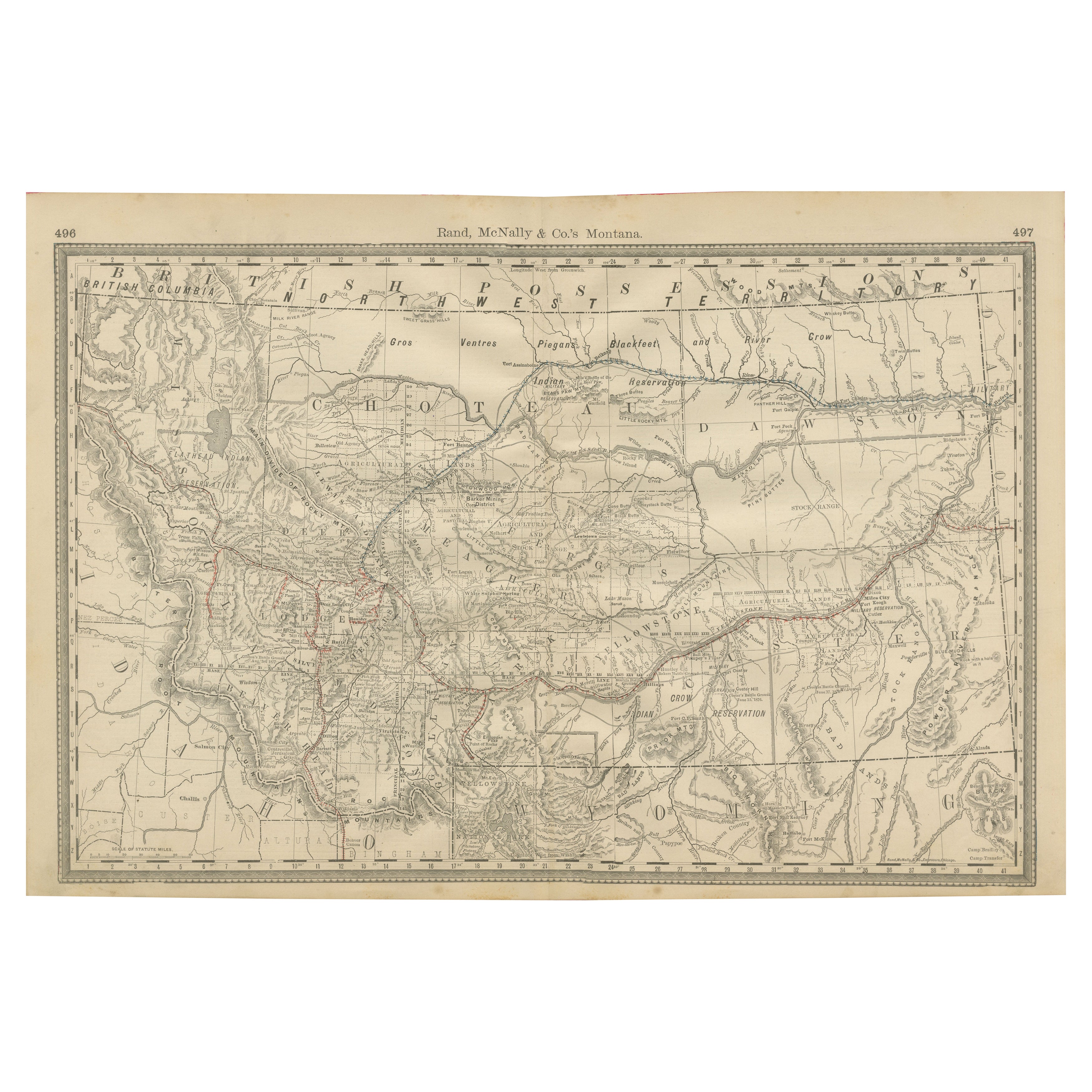
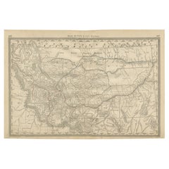
Old Map of Montana – Railroads, Indian Reservations
Frontier Settlements 1888
Located in Langweer, NL
Antique Map of Montana – Railroads, Indian Reservations & Frontier Settlements, 1888
This antique engraved map depicts the Territory of Montana in 1888, engraved and published by Ra...
Category
Antique Late 19th Century American Maps
Materials
Paper
You May Also Like
Original Antique Map of the American State of Texas ( Eastern Part ), 1903
Located in St Annes, Lancashire
Antique map of Texas ( Eastern part )
Published By A & C Black. 1903
Original colour
Good condition
Unframed.
Free shipping
Category
Antique Early 1900s English Maps
Materials
Paper
Original Antique Map of the American State of Colorado, 1903
Located in St Annes, Lancashire
Antique map of Colorado
Published By A & C Black. 1903
Original colour
Good condition
Unframed.
Free shipping
Category
Antique Early 1900s English Maps
Materials
Paper

Original Antique Map of the American State of Arizona
New Mexico, 1903
Located in St Annes, Lancashire
Antique map of Arizona and New Mexico
Published By A & C Black. 1903
Original colour
Good condition
Unframed.
Free shipping
Category
Antique Early 1900s English Maps
Materials
Paper

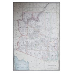
Large Original Antique Map of Arizona, Usa, C.1900
Located in St Annes, Lancashire
Fabulous map of Arizona
Original color.
Engraved and printed by the George F. Cram Company, Indianapolis.
Published, C.1900.
Unframed.
Free shipping.
Category
Antique 1890s American Maps
Materials
Paper
Original Antique Map of the American State of South Dakota, 1903
Located in St Annes, Lancashire
Antique map of South Dakota
Published By A & C Black. 1903
Original colour
Good condition
Unframed.
Free shipping
Category
Antique Early 1900s English Maps
Materials
Paper

Large Original Antique Map of Utah, USA, 1894
By Rand McNally
Co.
Located in St Annes, Lancashire
Fabulous map of Utah
Original color
By Rand, McNally & Co.
Published, 1894
Unframed
Free shipping.
Category
Antique 1890s American Maps
Materials
Paper
