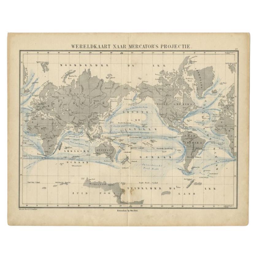
Items Similar to World Map in Mercator’s Projection – Nieuwe Hand-Atlas, Leiden 1876
Want more images or videos?
Request additional images or videos from the seller
1 of 9
World Map in Mercator’s Projection – Nieuwe Hand-Atlas, Leiden 1876
$276.21
£204.57
€230
CA$377.84
A$411.20
CHF 217.98
MX$4,947.08
NOK 2,764.66
SEK 2,529.47
DKK 1,752.64
About the Item
World Map in Mercator’s Projection – Nieuwe Hand-Atlas, Leiden 1876
This 19th-century Dutch world map, titled “Wereld-Kaart in Mercator’s Projectie,” was published in 1876 in the Nieuwe Hand-Atlas der Aarde in haren Tegenwoordigen Toestand by M. Frijlink, revised by A. van Otterloo, and printed by D. Noothoven van Goor in Leiden. The map presents the world according to the Mercator projection, designed to show accurate bearings for navigation while preserving recognizable continental forms.
The continents are delicately hand-colored to distinguish political boundaries: yellow for the Americas, green for Australia, pink for Asia, and soft blue for Europe and Africa. Ocean currents, major trade winds, and navigational routes are clearly indicated, making the plate both visually engaging and scientifically instructive. Across the map, fine engraved lines mark latitude and longitude, with detailed labeling of ports, islands, and key geographical features. A table at the bottom compares the surface areas of the continents and oceans, while another details the relative size of major countries and empires of the time, offering a clear view of global political geography in the late 19th century.
This map reflects the advanced level of Dutch cartographic education in the 1870s, combining clarity, accuracy, and aesthetic precision. It served as a practical and educational representation of the world for teachers, students, and scholars, produced by some of the leading mapmakers of the Netherlands.
Condition report:
Good condition for age, with light overall toning and minor foxing near the margins. Original center fold as issued. Two small black printing marks visible in the lower margin—one at left and one at right—likely from the original press. Colors remain soft and even, and the impression is strong with no tears or repairs.
Framing tips:
This map displays beautifully when mounted on a light ivory mat with a slim black or walnut wooden frame. The balance of muted colors and precise engraving complements both classic and modern interiors, especially in studies or offices.
Technique: Lithograph with original hand-coloring
Maker: M. Frijlink
A. van Otterloo, published by D. Noothoven van Goor, Leiden, 1876
- Dimensions:Height: 17.33 in (44 cm)Width: 21.66 in (55 cm)Depth: 0.01 in (0.2 mm)
- Materials and Techniques:
- Place of Origin:
- Period:
- Date of Manufacture:1876
- Condition:Good condition for age, with light overall toning and minor foxing near the margins. Original center fold as issued. Two small black printing marks visible in the lower margin—one at left and one at right—likely from the original press.
- Seller Location:Langweer, NL
- Reference Number:Seller: BG-12788-31stDibs: LU3054347450192
About the Seller
5.0
Recognized Seller
These prestigious sellers are industry leaders and represent the highest echelon for item quality and design.
Platinum Seller
Premium sellers with a 4.7+ rating and 24-hour response times
Established in 2009
1stDibs seller since 2017
2,816 sales on 1stDibs
Typical response time: 1 hour
- ShippingRetrieving quote...Shipping from: Langweer, Netherlands
- Return Policy
More From This Seller
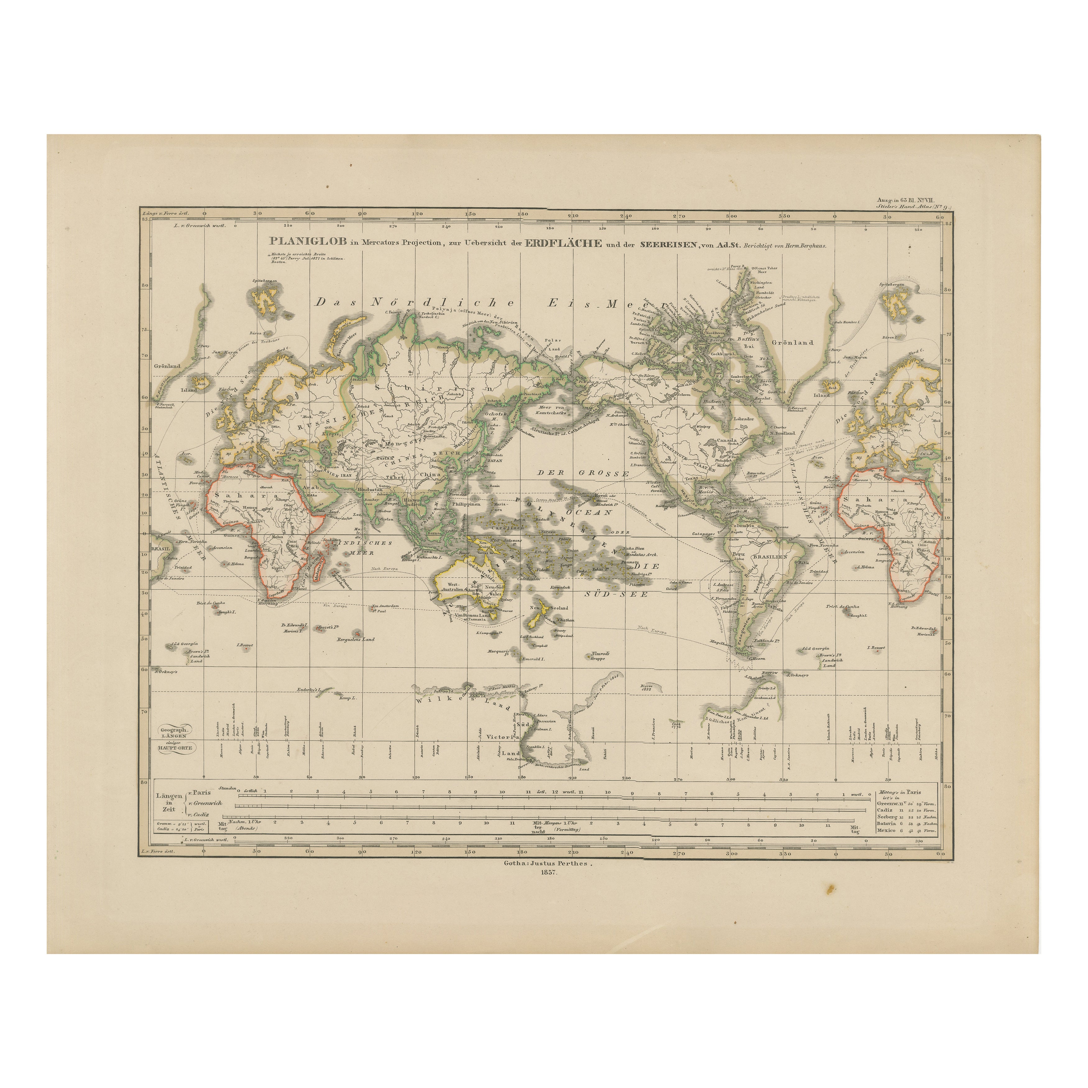
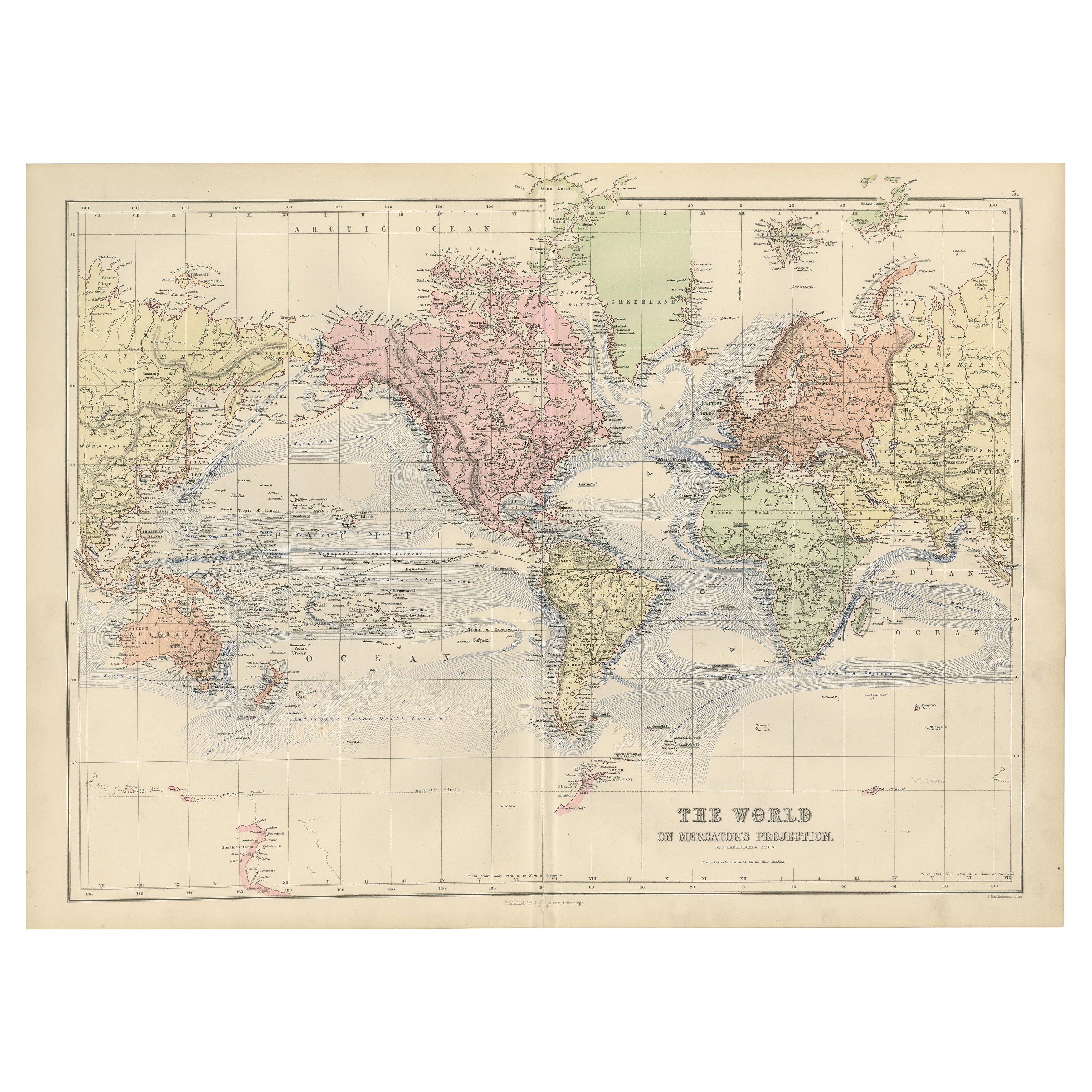
View AllWorld Map – Mercator Projection with Global Sea Routes, Published in 1857
Located in Langweer, NL
World Map – Mercator Projection with Global Sea Routes 1857
This attractive antique print shows a world map titled “Planiglob in Mercators Projection zur Übersicht der Erdfläche und...
Category
Antique Mid-19th Century German Maps
Materials
Paper

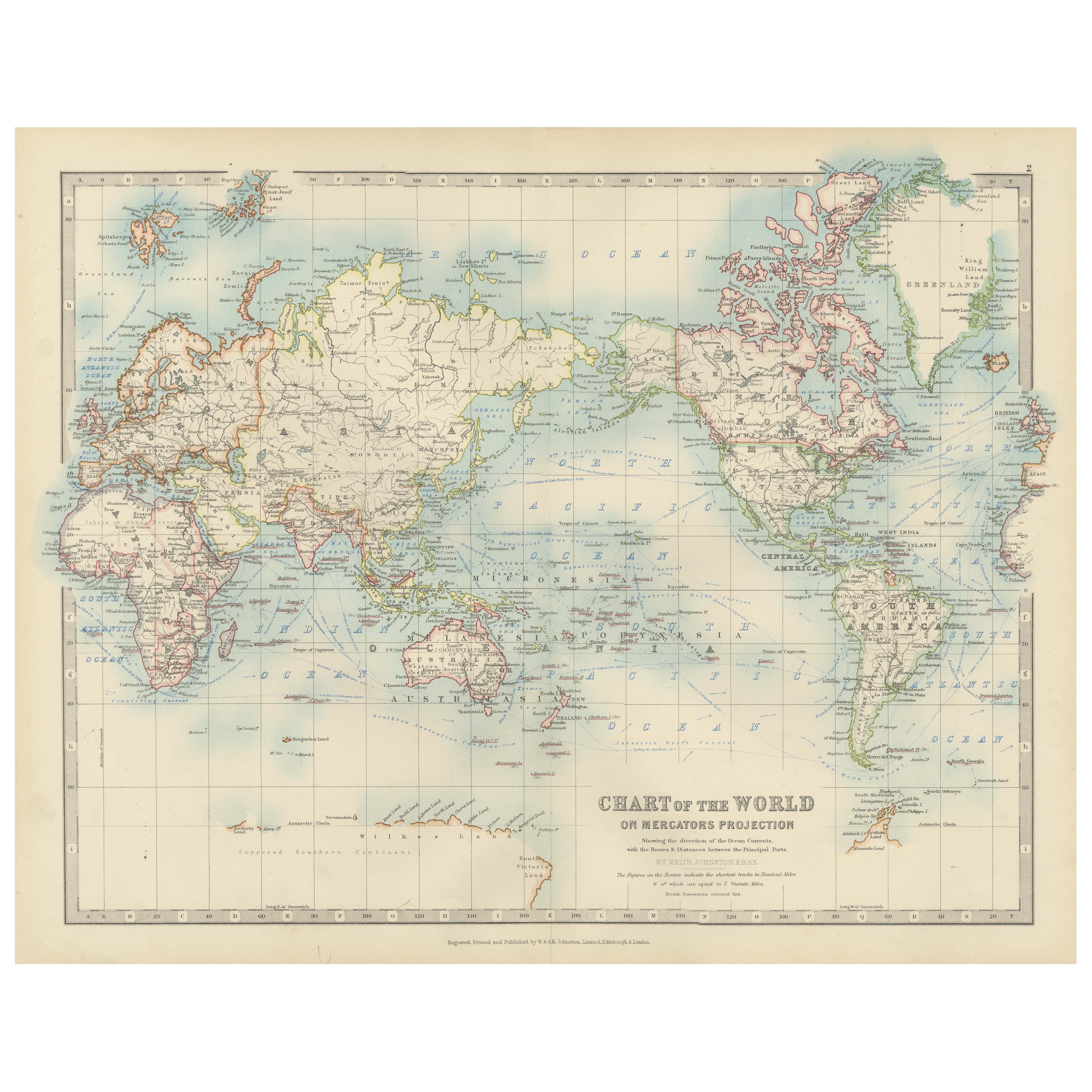
Antique World Map on Mercator
s Projection, Ocean Currents and Trade Routes 1903
Located in Langweer, NL
Title: Antique World Map on Mercator's Projection, 1903, Showing Ocean Currents and Trade Routes
Description:
This antique map, titled "Chart of the World on Mercator's Projection,"...
Category
Early 20th Century Maps
Materials
Paper

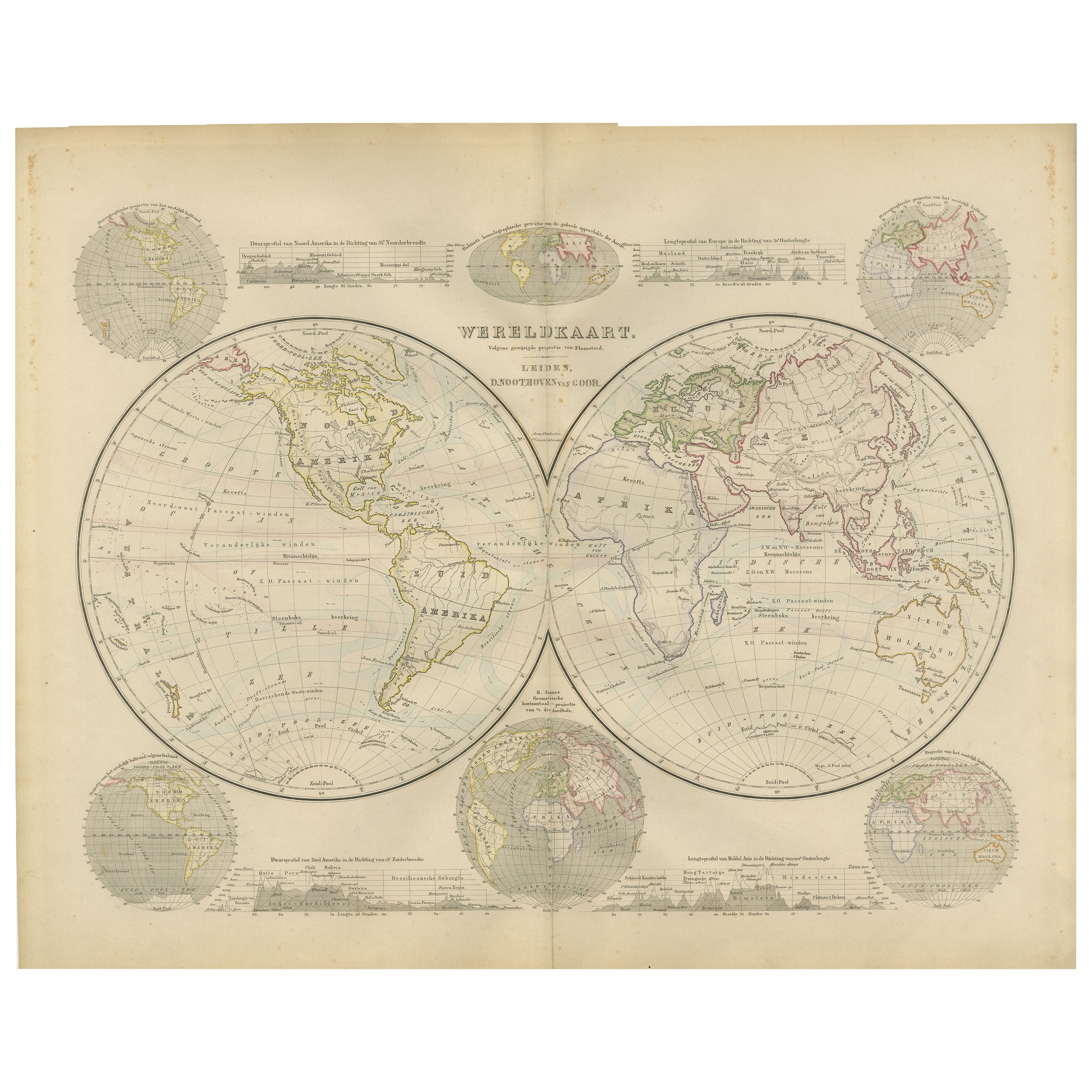
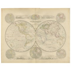
Double Hemisphere World Map from the Nieuwe Hand-Atlas, Leiden 1876
Located in Langweer, NL
Title: Double Hemisphere World Map from the Nieuwe Hand-Atlas, Leiden 1876
Description:
This 19th-century double-hemisphere world map, titled “Wereldkaart volgens gewone projectie v...
Category
Antique 1870s Dutch Maps
Materials
Paper
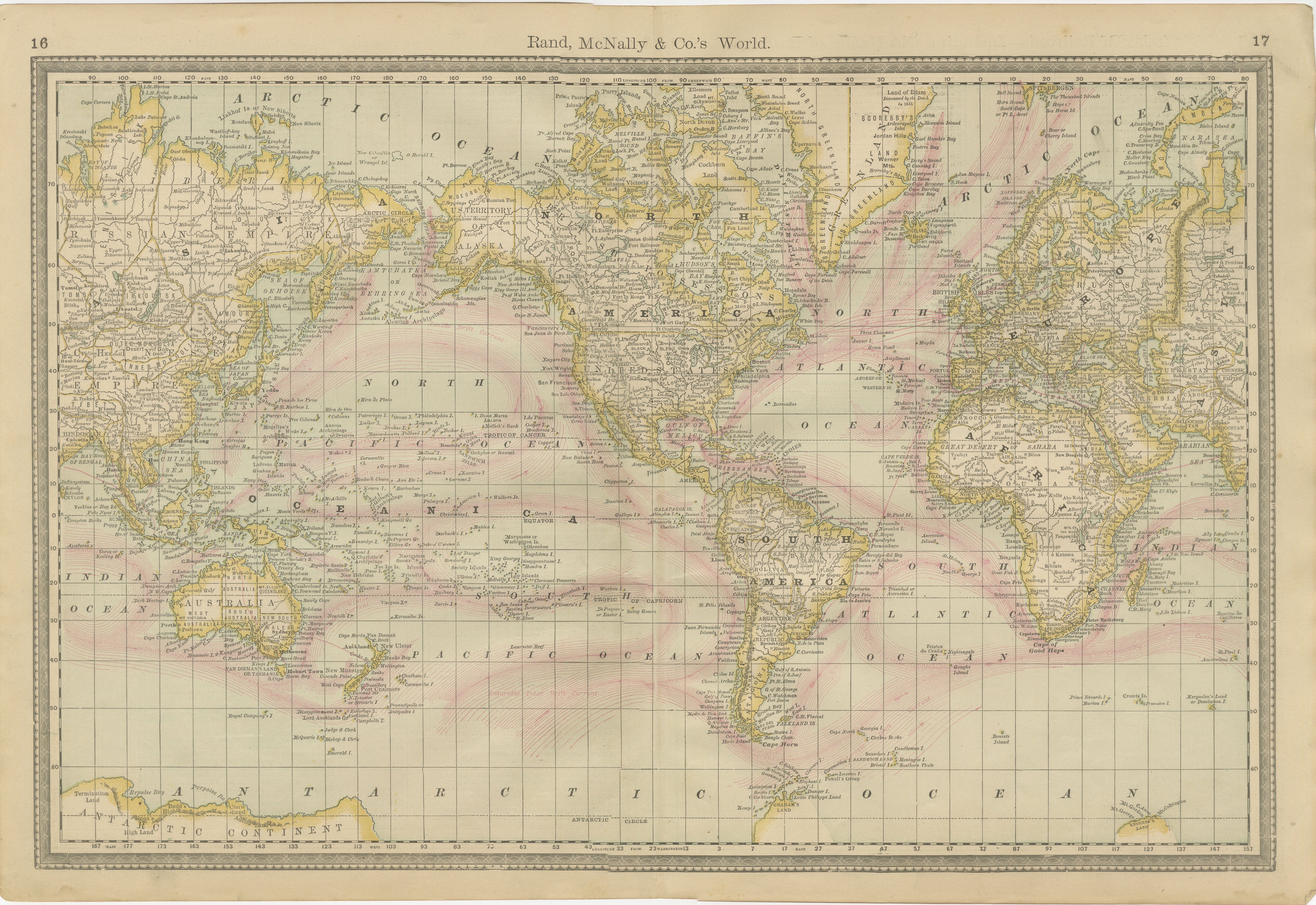
World Antique Map c.1888 – Rand McNally, Continents
Territories
Located in Langweer, NL
Antique Map of Mexico – Rand McNally, circa 1888
This antique map titled “Rand, McNally & Co.’s Mexico” was published around 1888 and depicts Mexico in the late 19th century, a peri...
Category
Antique Late 19th Century American Maps
Materials
Paper
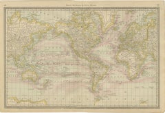
1884 Antique Decorative World Map – Mercator Projection, Victorian Era Print
Located in Langweer, NL
Antique World Map on Mercator’s Projection – Black’s Atlas, 1884
This finely engraved and colored map, titled The World on Mercator’s Projection, was published in the New and Revise...
Category
Antique 1880s Scottish Maps
Materials
Paper

Antique Mercator Projection World Map by Petri, c.1873
Located in Langweer, NL
Antique world map titled 'Wereldkaart naar Mercator's Projectie'. Old map of the world. This map originates from 'School-Atlas van alle Deelen der Aarde'.
Artists and engravers: ...
Category
Antique 19th Century Maps
Materials
Paper

You May Also Like
Original Antique Map of The World by Dower, circa 1835
Located in St Annes, Lancashire
Nice map of the World
Drawn and engraved by J.Dower
Published by Orr & Smith. C.1835
Unframed.
Free shipping
Category
Antique 1830s English Maps
Materials
Paper

1864 Original illustrated planisphere - World Map - Geography
Located in PARIS, FR
Immerse yourself in the epic journey of the past with the Illustrated Historical Planisphere of 1864 by Charpentier! 🗺️ This cartographic treasure transports you through the intrica...
Category
1860s Prints and Multiples
Materials
Linen, Paper, Lithograph

Antique Map of Eastern Hemisphere from the collection of Thierry Despont
Located in New York, NY
Designed by Enrico Bonetti (E. Bonatti) and published by Francesco Vallardi Editore. Based on an earlier map by Evangelista Azzi (Ev. Azzi). Labeled as such at bottom edge of map.
T...
Category
Antique Late 19th Century Italian Maps
Materials
Canvas, Wood

Original Antique Map of The Eastern Hemisphere by Dower, circa 1835
Located in St Annes, Lancashire
Nice map of the Eastern Hemisphere
Drawn and engraved by J.Dower
Published by Orr & Smith. C.1835
Unframed.
Free shipping
Category
Antique 1830s English Maps
Materials
Paper

Original Antique Map of The World by Thomas Clerk, 1817
Located in St Annes, Lancashire
Great map of The Eastern and Western Hemispheres
On 2 sheets
Copper-plate engraving
Drawn and engraved by Thomas Clerk, Edinburgh.
Published by Mackenzie And Dent, 1817
...
Category
Antique 1810s English Maps
Materials
Paper

Map of the World - Original Etching - 1820
Located in Roma, IT
Map of the World is an Original Etching realized by an unknown artist of 19th century in 1820.
Very good condition on two sheets of white paper joine...
Category
1820s Modern Figurative Prints
Materials
Etching
