1 of 10
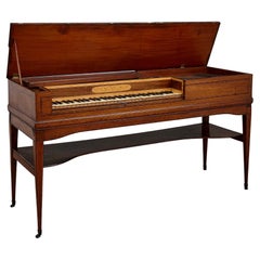
Ganer Square Piano c1780
$23,838.51List Price
About the Item
- Creator:Christopher Ganer (Maker)
- Dimensions:Height: 32.09 in (81.5 cm)Width: 60.63 in (154 cm)Depth: 20.67 in (52.5 cm)
- Materials and Techniques:
- Place of Origin:
- Period:
- Date of Manufacture:Circa 1780
- Condition:Please contact dealer for condition report.
- Seller Location:London, GB
- Reference Number:Seller: M293841stDibs: LU9758824616
Authenticity Guarantee
In the unlikely event there’s an issue with an item’s authenticity, contact us within 1 year for a full refund. DetailsMoney-Back Guarantee
If your item is not as described, is damaged in transit, or does not arrive, contact us within 7 days for a full refund. Details24-Hour Cancellation
You have a 24-hour grace period in which to reconsider your purchase, with no questions asked.Vetted Professional Sellers
Our world-class sellers must adhere to strict standards for service and quality, maintaining the integrity of our listings.Price-Match Guarantee
If you find that a seller listed the same item for a lower price elsewhere, we’ll match it.Trusted Global Delivery
Our best-in-class carrier network provides specialized shipping options worldwide, including custom delivery.You May Also Like
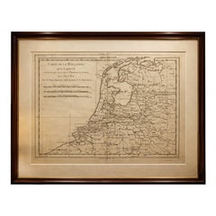
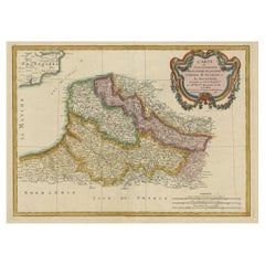
The Netherlands – Seven United Provinces Map, Bonne c1780
Located in Langweer, NL
The Netherlands – Seven United Provinces Map, Bonne c1780
Description:
This detailed map of the Dutch Republic shows the Seven United Provinces with dense networks of rivers, towns,...
Category
Antique Late 18th Century French Maps
Materials
Paper
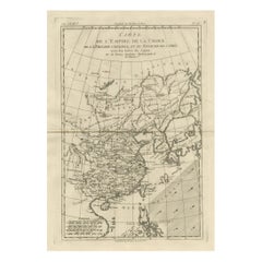
China, Korea
Japan – Antique East Asia Map, Bonne c1780
Located in Langweer, NL
China, Korea & Japan – Antique East Asia Map, Bonne c1780
Description: This map presents China, Korea, and Japan, including Tartary and surrounding seas. Rivers, mountain ranges, an...
Category
Antique Late 18th Century French Maps
Materials
Paper
British Isles – England, Scotland
Ireland Antique Map, Bonne c1780
Located in Langweer, NL
British Isles – England, Scotland & Ireland Map, Bonne c1780
Description:
This elegant map depicts England, Scotland, and Ireland with remarkable detail, showing counties, rivers, a...
Category
Antique Late 18th Century French Maps
Materials
Paper
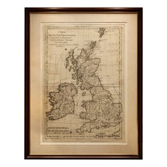
$378
H 16.15 in W 10.24 in D 0.01 in
Mozambique Channel
Madagascar – Antique African Sea Chart, Bonne c1780
Located in Langweer, NL
Mozambique Channel & Madagascar – Antique African Sea Chart, Bonne c1780
Description:
This finely engraved late-18th-century sea chart depicts the Mozambique Channel with Madagascar...
Category
Antique Late 18th Century French Maps
Materials
Paper
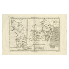
$378
H 10.24 in W 16.15 in D 0.01 in
Decorative Map of the French Regions of Picardy, Artois
French Flanders, c1780
Located in Langweer, NL
Antique map titled 'Carte des Gouvernements de Flandre Francoise, d'Artois, de Picardie et du Boulenois.'
An attractive example of Rigobert Bonne's 1771 decorative map of the Fre...
Category
Antique 1780s Maps
Materials
Paper
$653 Sale Price
20% Off
H 14.57 in W 19.49 in D 0 in
Old Map of the Great Lakes and Upper Mississippi Valley, Northern America, c1780
Located in Langweer, NL
Antique map titled 'Partie Occidentale du Canada'.
A fine example of Rigobert Bonne and Guilleme Raynal's 1780 map of the Great Lakes and upper Mississippi Valley.
A map of c...
Category
Antique 1780s Maps
Materials
Paper

$976
H 10.32 in W 14.85 in D 0 in
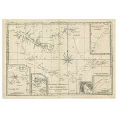
Copper Engraved Map of Tierra del Fuego and the Strait of Magellan, c1780
Located in Langweer, NL
Antique map titled 'Extremite Meridionale de l'Amerique.'
Copper engraved map of Tierra del Fuego and the Strait of Magellan with five detailed insets of the region showing soundings, anchorages, etc. Engraved by Andre. This map originates from 'Atlas de Toutes les Parties Connues du Globe Terrestre'.
Artists and Engravers: Rigobert Bonne (1727-1795 ) was one of the most important cartographers of the late 18th century. In 1773 he succeeded Jacques Bellin as Royal Cartographer to France in the office of the Hydrographer at the Depôt de la Marine. Working in his official capacity Bonne compiled some of the most detailed and accurate maps of the period. Bonne's work represents an important step in the evolution of the cartographic ideology away from the decorative work of the 17th and early 18th century towards a more detail oriented and practical aesthetic. With regard to the rendering of terrain Bonne maps...
Category
Antique 1780s Maps
Materials
Paper
$340 Sale Price
20% Off
H 12.21 in W 18.51 in D 0 in
Print of the Vegetation
Sun
Moon, from Frescoes in the Sistine Chapel, c1780
Located in Langweer, NL
Antique print religion titled 'Germinet Terra Herbam Virentem (..)'.
This print depicts the Vegetation and Sun and Moon. Originates from 'Frescoes in the Sistine Chapel...
Category
Antique 1780s Prints
Materials
Paper

$549 Sale Price
20% Off
H 20.87 in W 30.71 in D 0 in
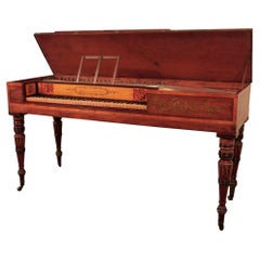
Antique George III Period Square Piano by Beck
Located in London, GB
Antique George III period square piano by Beck
English, 1788
Height 81cm, width 148cm, depth 52cm
This elegant instrument is a square piano, a type popul...
Category
Antique Late 18th Century English George III Musical Instruments
Materials
Wood
Broadwood Square Piano in Mahogany Hand-Painted Harlequin Inlay Border
Located in Leeds, GB
This Regency Broadwood is a fine example of a pretty square piano. The mahogany cabinet is accented with a black and white harlequin stringing border. The entire cabinet has been fin...
Category
Antique Late 18th Century English Regency Musical Instruments
Materials
Abalone, Mahogany, Paint
$10,755
H 33.08 in W 63.78 in D 22.84 in
Still Thinking About These?
All Recently ViewedMore Ways To Browse
Mahogany Piano
Antique Sieve
18th Century Piano
John Meyer
Vintage Guitars Electric Guitars
Vintage Juke
Vintage Turntable Furniture
1960 Speakers
Antique Erard Piano
Audio Speaker
Barrel Organ
Erard Pianos
Musical Bird Cage
Speakers Vintage Stereo
Used Musical Organs
Vintage 1960 Record Player
18th Century Piano
Antique Baby Grand