Want more images or videos?
Request additional images or videos from the seller
1 of 13
Chesapeake Bay Oyster Shipping Basket
$325List Priceper item
About the Item
- Dimensions:Height: 14 in (35.56 cm)Diameter: 16 in (40.64 cm)
- Materials and Techniques:
- Place of Origin:
- Period:
- Date of Manufacture:1970
- Condition:
- Seller Location:Norwell, MA
- Reference Number:Seller: 24NV2801stDibs: LU1741243338382
About the Seller
5.0
Vetted Professional Seller
Every seller passes strict standards for authenticity and reliability
Established in 1967
1stDibs seller since 2015
434 sales on 1stDibs
Typical response time: 6 hours
Authenticity Guarantee
In the unlikely event there’s an issue with an item’s authenticity, contact us within 1 year for a full refund. DetailsMoney-Back Guarantee
If your item is not as described, is damaged in transit, or does not arrive, contact us within 7 days for a full refund. Details24-Hour Cancellation
You have a 24-hour grace period in which to reconsider your purchase, with no questions asked.Vetted Professional Sellers
Our world-class sellers must adhere to strict standards for service and quality, maintaining the integrity of our listings.Price-Match Guarantee
If you find that a seller listed the same item for a lower price elsewhere, we’ll match it.Trusted Global Delivery
Our best-in-class carrier network provides specialized shipping options worldwide, including custom delivery.You May Also Like
1856 U.S. Coast Survey Map of Chesapeake Bay and Delaware Bay
Located in Colorado Springs, CO
Presented is U.S. Coast Survey nautical chart or maritime map of Chesapeake Bay and Delaware Bay from 1856. The map depicts the region from Susquehanna, Maryland to the northern Outer Banks in North Carolina. It also shows from Richmond and Petersburg, Virginia to the Atlantic Ocean. The map is highly detailed with many cities and towns labeled throughout. Rivers, inlets, and bays are also labeled. Various charts illustrating more specific parts of the region are marked on the map using dotted lines. The lines form boxes, and the corresponding chart number and publication date are given. Extensive triangulation surveys were conducted the length of Chesapeake Bay and are illustrated here. Hampton Roads, Virginia is labeled, along with the James, York, and Rappahannock Rivers, which were all extensively surveyed.
The chart was published under the supervision of A. D. Bache, one of the most influential and prolific figures in the early history of the U.S. Coast Survey, for the 1856 Report of the Superintendent of the U.S. Coast Survey. Alexander Dallas Bache (1806-1867) was an American physicist, scientist, and surveyor. Bache served as the Superintendent of the U.S. Coast Survey from 1843 to 1865. Born in Philadelphia, Bache toured Europe and composed an important treatise on European Education. He also served as president of Philadelphia's Central High School and was a professor of natural history and chemistry at the University of Pennsylvania. Upon the death of Ferdinand Rudolph Hassler, Bache was appointed Superintendent of the United States Coast Survey.
The Office of the Coast Survey, founded in 1807 by President Thomas Jefferson and Secretary of Commerce Albert Gallatin...
Category
Antique 1850s American Maps
Materials
Paper

Antique Map of Virginia
the Chesapeake Bay by Jacques-Nicolas Bellin, c. 1750
By Jacques-Nicolas Bellin
Located in Philadelphia, PA
A fine antique 18th century French map of North America.
By Jacques-Nicolas Bellin.
On laid paper with polychrome highlights.
Depicting Virginia, the Chesapeake Bay, and the nearb...
Category
Antique 18th Century French Baroque Maps
Materials
Paper

$895
H 15.13 in W 18.63 in D 1.13 in
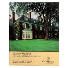
Contents of Broadhollow, Oyster Bay, Long Island, N.Y. Property of Percy Uris
Located in valatie, NY
The Contents of Broadhollow, Oyster Bay, Long Island, N.Y. The Property of the Estate of Mrs. Percy Uris, by Christie's (New York). This auction catalog consists of 122 pages with 1,...
Category
Vintage 1980s American Books
Materials
Paper
$50
H 10 in W 8 in D 0.25 in
Chesapeake Gardening and Landscaping by Barbara W. Ellis, Stated 1st Ed
Located in valatie, NY
Chesapeake Gardening and Landscaping, by Barbara W. Ellis. 1st Ed hardcover with dust jacket. Published by The University of North Carolina Press, Chapel Hill, 2015. "What if, one st...
Category
21st Century and Contemporary American Books
Materials
Paper

The Material World of Eyre Hall: Four Centuries of Chesapeake History, 1st Ed
Located in valatie, NY
The Material World of Eyre Hall: Four Centuries of Chesapeake History Edited by Carl R. Lounsbury. 1st Ed hardcover with dust jacket. Published by D Giles Ltd, London, 2021. This is ...
Category
21st Century and Contemporary American Books
Materials
Paper

$125
H 11.5 in W 9.25 in D 1.5 in
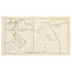
Antique Map of Cordes Bay, Port Famine, Woods Bay and Surroundings
Located in Langweer, NL
Antique map titled 'Baye et Havre de Cordes (..)'. Four maps on the one sheet of; Cordes Bay, Port Famine, Woods Bay, Port Gallant, Fortescue Bay, Chile based on the voyage of John B...
Category
Antique Late 18th Century Maps
Materials
Paper
$314 Sale Price
20% Off
H 9.93 in W 16.78 in D 0.02 in
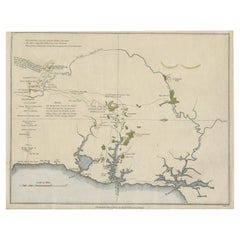
Early Map of Sydney with Botany Bay, Port Jackson
Broken Bay, Australia, 1802
Located in Langweer, NL
Interesting chart of the three harbours of Botany Bay, Port Jackson, and Broken Bay showing the ground cultivated by the colonists. In the early days of the settlement in Australia t...
Category
Antique Early 1800s Maps
Materials
Paper
$1,346
H 10.24 in W 12.01 in D 0 in
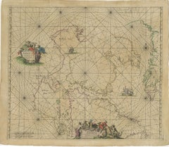
1690 Frederick de Wit Sea Chart of Hudson Bay, Baffin Bay and Greenland
Located in Langweer, NL
Title: c. 1690 Frederick de Wit Sea Chart of Hudson Bay, Baffin Bay, and Greenland - Engraved by Romeyn de Hooghe
This striking sea chart by Frederick de Wit, titled "Septemtrionali...
Category
Antique 1690s Maps
Materials
Paper
$1,596
H 21.07 in W 24.22 in D 0.01 in
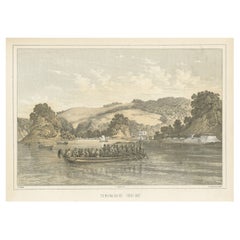
Antique Print of Tokyo Bay
or Edo Bay
, Located in Southern Kantō, Japan, 1856
Located in Langweer, NL
Antique print titled 'To-Ri-Ga-Sa-Ki, Yedo Bay'. View of Tokyo Bay (or Edo Bay), a bay located in the southern Kanto region of Japan, and spans the coasts of Tokyo, Kanagawa Prefectu...
Category
Antique 1850s Maps
Materials
Paper
$324 Sale Price
20% Off
H 8.27 in W 11.03 in D 0 in
Private Gardens of the Bay Area
By Phaidon
Located in New York, NY
Seasoned garden writers Susan Lowry and Nancy Berner, along with leading landscape photographer Marion Brenner, tour more than thirty-five private gardens in the San Francisco Bay Ar...
Category
2010s Chinese Books
Materials
Paper

More From This Seller
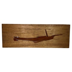
View AllCrude Half Model of a Chesapeake Bay Skipjack
Located in Norwell, MA
Carved half model of a Chesapeake Bay Skipjack. Laminated hull.
Weight: 4 lbs.
Overall Dimensions: 9" H x 26" W x 3" D.
Made: America
Material: Wood
Date: 1940
Category
Vintage 1940s Models and Miniatures
Materials
Wood
1898 Chart of Boston Bay
Located in Norwell, MA
Original 1898 chart showing Massachusetts Bay with the coast from Cape Ann to Cape Cod. This is a U.S. Navy Geodetic survey chart. All towns are noted along the coast. Framed with gl...
Category
Antique 1890s Nautical Objects
Materials
Paper

$1,495
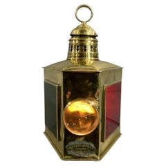
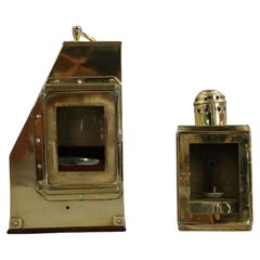
WM Porter and Sons Ships Lantern
By Perkins Marine Lamp
Located in Norwell, MA
Solid brass bow boat lantern with markers badge from WM Porter and Sons, nineteenth century. Fitted with flat red and green port and starboard lenses and a bulbous clear bow lens. Hi...
Category
Antique 1890s American Nautical Objects
Materials
Brass
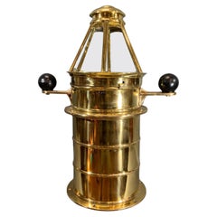
Outstanding Solid Brass Yacht Binnacle circa 1920
By E.S. Ritchie
Sons 1
Located in Norwell, MA
Solid brass yacht binnacle with highly polished and lacquered finish. Fitted with a compass by Ritchie of Boston. The binnacle is topped with a six sided skylight top. The base is so...
Category
Vintage 1920s American Nautical Objects
Materials
Brass
Thaxter of Boston Yacht Binnacle
By Samuel Thaxter
Located in Norwell, MA
Solid brass yacht binnacle with highly polished case and compass, sidelight, and carry ring. Maker is Samuel Thaxter of Boston.
Overall Dimensions: 10"H x 6"D x 9"L. 5 pounds.
Category
Antique Early 1900s Nautical Objects
Materials
Brass
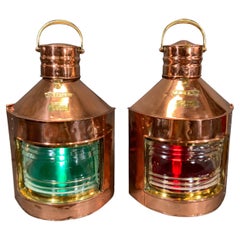
Pair of Copper Port and Starboard Ships Lanterns by Meteorite, "25029"
"19203"
By Meteorite
Located in Norwell, MA
Pair of solid copper and brass ship's port and starboard ships lanterns by the venerable and famous English maker "Meteorite." The copper cases are fitted with brass labels including port, starboard and Meteorite plates with serial numbers "25029" and "19203". These have clear Fresnel glass lenses with removable colored filters. Heavy brass lens...
Category
Vintage 1940s English Nautical Objects
Materials
Copper
Still Thinking About These?
All Recently ViewedMore Ways To Browse
Used Furniture North Bay
Yacht Corsair
Antique Iron Pulley
Dry Compass
Ship Half Models
Sovereign Of The Seas
Antique Kayak
Antique Porthole Window
Antique Sextant
Antique Ship Helm
Antique Ship Pulley
Antique Ships Telegraph
Boat Plans
Brass Steering Wheel
Mahogany Ship Wheel
Nautical Lens
Nautical Sextants
Pilot Boats