1 of 8
Mosaic of the Virgin and Apostles
$6,800List Price
About the Item
- Dimensions:Height: 36 in (91.44 cm)Width: 26 in (66.04 cm)Depth: 1.75 in (4.45 cm)
- Materials and Techniques:
- Place of Origin:
- Period:
- Date of Manufacture:circa 1900
- Condition:Wear consistent with age and use. bright colors not one missing mosaic tile, as far as we can see.
- Seller Location:Woodbury, CT
- Reference Number:Seller: E85PM61201stDibs: LU862619399802
Authenticity Guarantee
In the unlikely event there’s an issue with an item’s authenticity, contact us within 1 year for a full refund. DetailsMoney-Back Guarantee
If your item is not as described, is damaged in transit, or does not arrive, contact us within 7 days for a full refund. Details24-Hour Cancellation
You have a 24-hour grace period in which to reconsider your purchase, with no questions asked.Vetted Professional Sellers
Our world-class sellers must adhere to strict standards for service and quality, maintaining the integrity of our listings.Price-Match Guarantee
If you find that a seller listed the same item for a lower price elsewhere, we’ll match it.Trusted Global Delivery
Our best-in-class carrier network provides specialized shipping options worldwide, including custom delivery.You May Also Like
Wonderful Antique Painting of Christ and Two Apostles in Ebonized Wooden Frame
Located in Lisse, NL
Meaningful and perfect size, religious work of art.
We find it refreshing to see Christ in this original 1913 oil painting as the spiritual master that he was (in a ceremonial act) ...
Category
Early 20th Century European Renaissance Religious Items
Materials
Linen, Wood, Paint

$2,651
Free Shipping
H 34 in W 26.75 in D 3 in
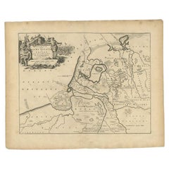
Antique Map of the Old Land of Batavia and FriesLand, The Netherlands, 1697
Located in Langweer, NL
Antique map Friesland titled 'Descriptio veteris Agri Batavi et Frisii (..)'. Old map of Friesland, the Netherlands. Depicts the old land of Batavia and Friesland. This map originate...
Category
Antique 17th Century Maps
Materials
Paper
$225
H 16.15 in W 19.89 in D 0 in
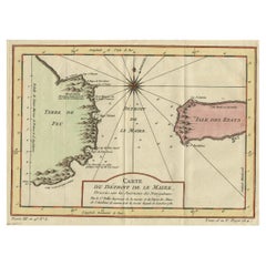
Antique Map of the Passage Between the Atlantic and Pacific Oceans, circa 1753
Located in Langweer, NL
Antique print, titled: 'Carte du Detroit de le Maire (…)' - This chart illustrates the important passage between the Atlantic and Pacific oceans. Jacob Le Maire and Willem Schouten d...
Category
Antique 18th Century Maps
Materials
Paper
$219 Sale Price
20% Off
H 9.61 in W 12.8 in D 0 in
Original Engraved Antique Map of the World, Colorful and Decorative, C.1780
By Pierre François Tardieu
Located in Langweer, NL
Antique map titled 'Mappemonde en Deux Hemispheres ou l'on a Indique les Nouvelles Decouvertes' - This handsome double hemisphere map presents a ...
Category
Antique 18th Century Maps
Materials
Paper

$449 Sale Price
20% Off
H 15.6 in W 20.32 in D 0 in
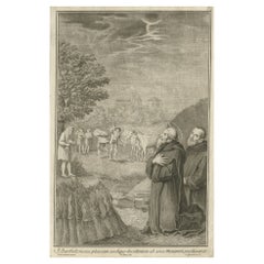
Antique Print of Bartholomew the Apostle, 1762
By Pietro Antonio Pazzi
Located in Langweer, NL
Antique print titled 'S. Bartholomaeus pluvian undique decidentem ab area Monasterii precibus arcet'. Scarce plate showing Bartholomew the Apostle in the ...
Category
Antique 18th Century Prints
Materials
Paper
Antique Map of the Region Near the Gulf of Zula, 1870
Located in Langweer, NL
Antique map titled 'Map of the Country between Annesley Bay and the Plain of Salt'. Lithographed map of the region near the Gulf of Zula, also known as Annesley Bay, Baia di Arafali ...
Category
Antique Mid-19th Century Maps
Materials
Paper

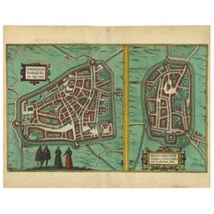
Antique Map of The Frisian Cities Leeuwarden and Franeker in Friesland, 1580
Located in Langweer, NL
Antique map titled 'Lewardum Occidentlis Frisiae Opp: 1580, Franicher Nobiliu hominum, in Frisia Occidentali, ut plurimum saedes'.
This sheet contains two very detailed bird?s-ey...
Category
Antique 16th Century Maps
Materials
Paper
$777
H 19.69 in W 15.36 in D 0 in
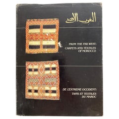
From the Far West Carpets and Textiles of Morocco Hardcover Book
By Berber Tribes of Morocco
Located in Moreno Valley, CA
From the Far West Carpets and Textiles of Morocco
Fiske, Patricia L. and Pickering, W. Russell and Yohe, Ralph S.
in black cloth covered board ...
Category
Vintage 1980s Moroccan Modern Books
Materials
Paper
Large Original Antique Map of the The Windward Islands. 1894
Located in St Annes, Lancashire
Superb Antique map of The Windward Islands
Published Edward Stanford, Charing Cross, London 1894
Original colour
Good condition
Unframed.
Free shipping
Category
Antique 1890s English Maps
Materials
Paper

$150
Free Shipping
H 29.5 in W 22 in D 0.07 in
Antique Map of South East Asia, Australia and the Indian Ocean, 1726
By F. Valentijn
Located in Langweer, NL
Antique map titled 'Tabula Indiae Orientalis'.
Beautiful detailed map of Australia, Southeast Asia and the Indian Ocean. The map features a fine depiction of the outlines of the western two-thirds of Australia, based on the discoveries of explorers working for the Dutch East India Company (the VOC). These include Willem Jansz's discoveries in the Gulf of Carpentaria in 1606; the encounters of Dirk...
Category
Antique Mid-18th Century Dutch Maps
Materials
Paper

$6,886 Sale Price
20% Off
Free Shipping
H 20.67 in W 27.17 in D 0.02 in
Still Thinking About These?
All Recently ViewedMore Ways To Browse
Religious Mosaic
Votive Candle Church Stand
Antique Wrought Iron Cross
Vellum Music
Church Confessional
Ukraine Menorah
Antique Ethiopian Coptic Cross
Arie Ofir
Carmel Shabi
Polish Kiddush Cup
Pulpits Used
Antique Miniature Bibles
Corner Pew
Gorham Snowflake
Gorham Sterling Silver Snowflake
Henderson Chair Company
Moshe Zabari
Silver Plated Bible