Want more images or videos?
Request additional images or videos from the seller
1 of 10
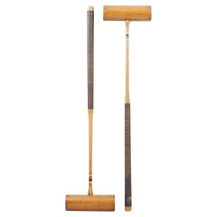
Antique Polo Mallet by J. Salter, Aldershot.
Price:$454.41
$523.27List Price
About the Item
- Dimensions:Height: 51.58 in (131 cm)Width: 7.68 in (19.5 cm)Depth: 1.78 in (4.5 cm)
- Materials and Techniques:
- Place of Origin:
- Period:
- Date of Manufacture:Circa 1890s
- Condition:Wear consistent with age and use. Shaft is slightly warped.
- Seller Location:Oxfordshire, GB
- Reference Number:Seller: 157001stDibs: LU975737994702
About the Seller
5.0
Platinum Seller
Premium sellers with a 4.7+ rating and 24-hour response times
Established in 1977
1stDibs seller since 2013
832 sales on 1stDibs
Typical response time: 4 hours
Associations
LAPADA - The Association of Arts
Antiques Dealers
Authenticity Guarantee
In the unlikely event there’s an issue with an item’s authenticity, contact us within 1 year for a full refund. DetailsMoney-Back Guarantee
If your item is not as described, is damaged in transit, or does not arrive, contact us within 7 days for a full refund. Details24-Hour Cancellation
You have a 24-hour grace period in which to reconsider your purchase, with no questions asked.Vetted Professional Sellers
Our world-class sellers must adhere to strict standards for service and quality, maintaining the integrity of our listings.Price-Match Guarantee
If you find that a seller listed the same item for a lower price elsewhere, we’ll match it.Trusted Global Delivery
Our best-in-class carrier network provides specialized shipping options worldwide, including custom delivery.You May Also Like
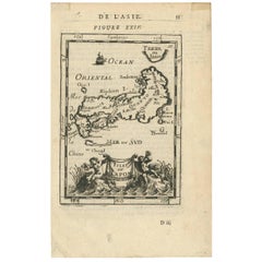
Antique Map of Japan by A.M. Mallet, 1683
Located in Langweer, NL
A charming late 17th century French map with a very decorative title cartouche showing trumpet-blowing cherubs, by Allain Manneson Mallet (1630-1706), a well traveled military engine...
Category
Antique Late 17th Century French Maps
Materials
Paper
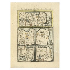
Antique Map of Northern Asia by Mallet, 1719
Located in Langweer, NL
Antique map titled 'Das Mitternächtige Theil des Alten Asien'. This sheet of five miniature maps describes the northern part of Asia in classical times, perhaps circa 150 AD. At the top, an overview map shows the main regions and territories, which are pictured in more detail below. From left to right, the four maps below depict Scythia east of the Imaus (Pamir) Mountains, Serica, Sychia west of the Pamir mountains, and Sarmatia, the last of which borders the Black Sea. Originates from Alain Manesson Mallet's 'Description de l 'Univers' (German edition). Artists and Engravers: Alain Manesson Mallet (1630-1706) was a French cartographer and engineer. He started his career as a soldier in the army of Louis XIV, became a Sergeant-Major in the artillery and an Inspector of Fortifications. He also served under the King of Portugal, before returning to France, and his appointment to the court of Louis XIV. His military engineering and mathematical background led to his position teaching mathematics at court. His major publications were Description de L'Univers (1683) in 5 volumes, and Les Travaux de Mars ou l'Art de la Guerre (1684) in 3 volumes. His Description de L'Universe contains a wide variety of information, including star maps...
Category
Antique 18th Century Maps
Materials
Paper
Vintage Jack Vandell 14 Karat Gold
Emerald Polo Mallet Brooch or Pendant
Located in Hamilton, Ontario
This vintage brooch or pendant was made by the well known Jack Vandell studio of the United States and dates to approximately 1970 and done in a Modern style. The piece is composed o...
Category
Late 20th Century American Modern Collectible Jewelry
Materials
Gold
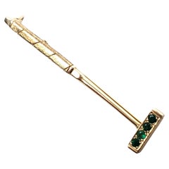
$3,500
H 0.25 in W 2.25 in D 0.75 in
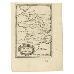
Detailed Antique Miniature Map of France by Mallet, c.1683
Located in Langweer, NL
Antique map titled 'France en General'. BG-11796-55. Originates from Mallet's 'Description de l'Univers'.
Artists and Engravers: Alain Manneson Mallet (1630-1706) spent the first ...
Category
Antique 17th Century Maps
Materials
Paper
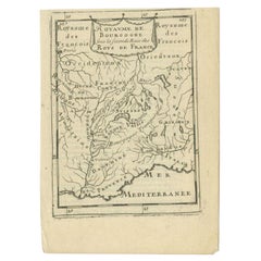
Antique Map of the Burgundy Region by Mallet, c.1683
Located in Langweer, NL
Antique map titled 'Royaume de Bourgogne sous la seconde Race des Roys de France'. Detailed miniature map of the Burgundy region, France. Originates from Mallet's 'Description de l'U...
Category
Antique 17th Century Maps
Materials
Paper
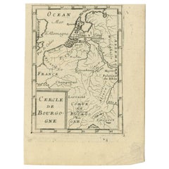
Antique Map of the Burgundy Region by Mallet, c.1683
Located in Langweer, NL
Antique map titled 'Cercle de Bourgogne'. Detailed miniature map of the Burgundy region, France. Also shows the Netherlands and Belgium. Originates from Mallet's 'Description de l'Un...
Category
Antique 17th Century Maps
Materials
Paper
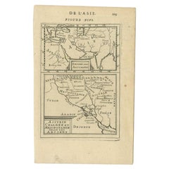
Antique Map of the Empire of the Assyriens by Mallet, 1683
By Alain Manesson Mallet
Located in Langweer, NL
Antique map titled 'Empire des Assyriens' and 'Assyrie Chaldee et Mesopotamie selon les Anciens'. Two maps on one sheet, the upper sheet showing the Empire of the Assyriens and the second showing the region of the Tigres and Euphrates Rivers. This map originates from Alain Manesson Mallet's 'Description de l 'Univers'.
Artists and Engravers: Alain Manesson Mallet (1630–1706) was a French cartographer and engineer. He started his career as a soldier in the army of Louis XIV, became a Sergeant-Major in the artillery and an Inspector of Fortifications. He also served under the King of Portugal, before returning to France, and his appointment to the court of Louis XIV. His military engineering and mathematical background led to his position teaching mathematics at court. His major publications were Description de L'Univers (1683) in 5 volumes, and Les Travaux de Mars ou l'Art de la Guerre (1684) in 3 volumes. His Description de L'Universe contains a wide variety of information, including star maps...
Category
Antique 17th Century Maps
Materials
Paper
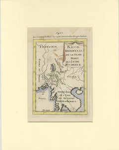
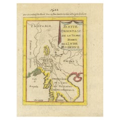
Antique Map of Northern India and the Bengal Gulf by Mallet, 1686
Located in Langweer, NL
This is a fine example of 17th or early 18th-century cartography, showcasing Southeast Asia, including parts of India, China, and the Gulf of Bengal. The French-labeled map highlights early European understanding of the Orient during the Age of Exploration.
Mounted in a soft cream matting board, the presentation enhances the map’s historical appeal while protecting its delicate condition.
The map features detailed geographical elements such as rivers, coastal lines, and mountain ranges. Regions like Tartarie, the Presqu'Isle de l'Inde, and the Golfe de Bengala are illustrated with early cartographic precision. Subtle hand-coloring highlights borders and coastal areas, adding to its visual charm.
In terms of condition, the map is well-preserved with clean paper with some waterdamage in the top, light toning, intact margins, and no visible tears or damage. The hand-coloring remains vibrant, reflecting careful handling over centuries.
This map provides insight into the evolving European knowledge of Asia and would make a distinguished addition to any collection of antique maps or historical artifacts.
Antique map titled "Partie Orientale de la Terre Ferme de l'Inde Moderne". Original antique map of the northern part of India and the Bengal Gulf. This map originates from Alain Manesson Mallet's 'Description de l 'Univers'. Artists and Engravers: Alain Manesson Mallet (1630?1706) was a French cartographer and engineer. He started his career as a soldier in the army of Louis XIV, became a Sergeant-Major in the artillery and an Inspector of Fortifications. He also served under the King of Portugal, before returning to France, and his appointment to the court of Louis XIV. His military engineering and mathematical background led to his position teaching mathematics at court. His major publications were Description de L'Univers (1683) in 5 volumes, and Les Travaux de Mars ou l'Art de la Guerre (1684) in 3 volumes. His Description de L'Universe contains a wide variety of information, including star maps...
Category
Antique 17th Century Maps
Materials
Paper
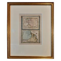
Antique Map of India and the Gulf of Bengal by Mallet, c.1686
Located in Langweer, NL
Antique map titled ?Partie Orientale de la Terre Ferme de l'Inde Moderne. Small map of India and the Gulf of Bengal. This map originates from a German edition of 'Description de l' Univers'.
Artists and Engravers: Alain Manesson Mallet (1630-1706) was a French cartographer and engineer. He started his career as a soldier in the army of Louis XIV, became a Sergeant-Major in the artillery and an Inspector of Fortifications. He also served under the King of Portugal, before returning to France, and his appointment to the court of Louis XIV. His military engineering and mathematical background led to his position teaching mathematics at court. His 'Description de L'Universe' contains a wide variety of information, including star maps...
Category
Antique 17th Century Maps
Materials
Paper
Antique Miniature Map of France and the Low Countries by Mallet, circa 1719
Located in Langweer, NL
Antique map titled 'France - Païs-Bas'. Miniature Map of France and the Low Countries. Published by A.M. Mallet, circa 1719.
Frame included. We carefully pack our framed items to ...
Category
Antique Early 18th Century Maps
Materials
Paper
$168 Sale Price
20% Off
H 11.82 in W 9.45 in D 0.6 in
More From This Seller
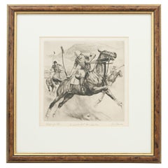
View AllPolo Engraving, California Polo by Reinhold H. Palenske
Located in Oxfordshire, GB
California Polo Etching.
A wonderful dry-point etching of Polo in America by American artist Reinhold H. Palenske (1884-1953). Inscribed and signed by th...
Category
20th Century American Sporting Art Prints
Materials
Paper
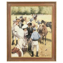
Polo Painting by Rossi, at the Polo Match
By Alberto Rossi
Located in Oxfordshire, GB
Polo oil painting "At The Polo Match", By Alberto Rossi.
This is a beautiful colourful original oil on board painting by renowned Italian artist Al...
Category
Antique 1890s Italian Sporting Art Decorative Art
Materials
Paper
$10,740 / set
Pair Of Jaques Croquet Mallets
Located in Oxfordshire, GB
Pair of John Jaques Association Croquet Mallets.
A pair of usable Jaques Boxwood croquet mallets, with ebony alignment lines, octagonal ash handles (which helps a player 'feel' the a...
Category
20th Century English Sports Equipment and Memorabilia
Materials
Boxwood, Ash
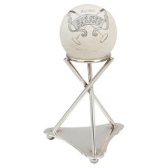
Holmes Polo Trophy
Located in Oxfordshire, GB
Vintage Polo Trophy.
A white wooden polo ball on a plated tripod stand. The polo ball painted with two crossed polo mallets, a banner reading 'HOLMES TROPHY,...
Category
21st Century and Contemporary British Sports Equipment and Memorabilia
Materials
Silver Plate
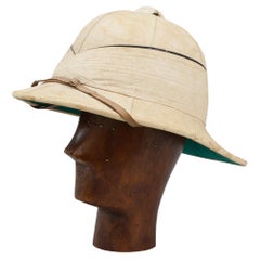
Polo Or Pith Helmet By Gieves Of London
Located in Oxfordshire, GB
Gieves Royal Navy Officer's Tropical Helmet, Pith Helmet, Solar Topee.
A good Gieves Ltd. 'Wolseley pattern' solar topee (also known as a pith helmet, safari helmet, sun helmet or so...
Category
Early 20th Century British Sports Equipment and Memorabilia
Materials
Canvas, Cork
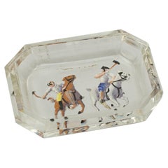
Vintage Intaglio Polo Glass Pin Tray
Located in Oxfordshire, GB
Vintage Intaglio Polo Glass Pin Tray.
A small glass pin tray with intaglio images of polo players set into the base, which have then been painted. The sma...
Category
Vintage 1930s Sports Equipment and Memorabilia
Materials
Glass
Still Thinking About These?
All Recently ViewedMore Ways To Browse
Bamboo Root
Polo Equipment
Polo Mallet
Vintage Western Saddles
Wooden Walking Stick
Antique Snooker Tables
Billiard And Snooker Tables
Bramble Golf Ball
Cowboy Collectibles
Cricket Bats
English Walking Canes
Jockey English
Used Fly Fishing Rods
Antique Hunting Flasks
Billiard Art
Boxing Bag
Mid Century Gym Equipment
Mountaineering Vintage