1 of 4
Skateboard by Nash, Sidewalk Surfboard #4, 34" Long
$450List Price
About the Item
- Creator:Nash (Designer)
- Dimensions:Height: 34.25 in (87 cm)Width: 6.25 in (15.88 cm)Depth: 3.75 in (9.53 cm)
- Materials and Techniques:
- Place of Origin:
- Period:
- Date of Manufacture:early 1960s
- Condition:
- Seller Location:Los Angeles, CA
- Reference Number:1stDibs: U1206119219132
Authenticity Guarantee
In the unlikely event there’s an issue with an item’s authenticity, contact us within 1 year for a full refund. DetailsMoney-Back Guarantee
If your item is not as described, is damaged in transit, or does not arrive, contact us within 7 days for a full refund. Details24-Hour Cancellation
You have a 24-hour grace period in which to reconsider your purchase, with no questions asked.Vetted Professional Sellers
Our world-class sellers must adhere to strict standards for service and quality, maintaining the integrity of our listings.Price-Match Guarantee
If you find that a seller listed the same item for a lower price elsewhere, we’ll match it.Trusted Global Delivery
Our best-in-class carrier network provides specialized shipping options worldwide, including custom delivery.You May Also Like
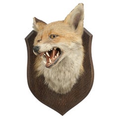
Taxidermy Fox
s Mask by Spicer of Lemington
Located in Oxfordshire, GB
Vintage Fox Mask By Peter Spicer.
This prepared fox mask, fox head, is mounted on a good quality oak shield impressed to reverse 'P. Spicer & Sons, Leami...
Category
Vintage 1920s English Sporting Art Taxidermy
Materials
Animal Skin
Antique Map of Korea by Kozaki, 1903
Located in Langweer, NL
Old map of Korea by S. Kozaki. Restored and mounted.
Category
20th Century Maps
Materials
Paper

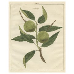
Antique Print of a Chestnut by Knoop, 1758
Located in Langweer, NL
Antique print of a chestnut. Originates from 'Pomologia' by J. H. Knoop.
Artists and Engravers: Published by Johann Hermann Knoop (c.1700-1769).
Condition: Good, general age-re...
Category
Antique 18th Century Maps
Materials
Paper
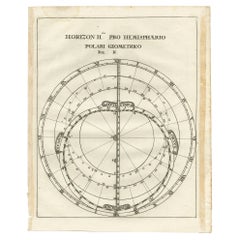
Antique Map of a Hemisphere by Scherer, c.1703
Located in Langweer, NL
Antique map depiciting a horizon/hemisphere. Printed for Scherer's 'Atlas Novus' (1702-1710).
Artists and Engravers: Heinrich Scherer (1628-1704) was a Professor of Hebrew, Mathematics and Ethics at the University of Dillingen until about 1680. Thereafter he obtained important positions as Official Tutor to the Royal Princes...
Category
Antique 18th Century Maps
Materials
Paper
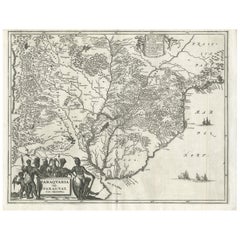
Antique Map of Paraguay by A. Montanus, circa 1671
By Arnoldus Montanus
Located in Langweer, NL
Antique map titled 'Paraquaria Vulgo Paraguay Cum adjacentibus'. Antique map extending from Rio de Janiero to the Rio de la Plata basin. The map include...
Category
Antique Mid-17th Century Maps
Materials
Paper
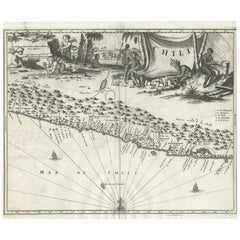
Antique Map of Chili by Montanus, circa 1671
By Arnoldus Montanus
Located in Langweer, NL
Antique map titled 'Chili'. A very attractive map covering the known coastal region of Chile. The Andes are shown prominently, with two live volcanoes in the vicinity of Villarrica. ...
Category
Antique Mid-17th Century Maps
Materials
Paper
Antique Map Eastern Mediterranean by D. Stoopendaal
circa 1710
Located in Langweer, NL
Antique map Middle East titled 'De Beschryving van de Reysen Pauli en van de Andere Apostelen'. Antique map of the Eastern Mediterranean with details of the travels by Apostle Paul...
Category
Antique Early 18th Century Dutch Maps
Materials
Paper

Antique Map of Asia by Dufour, circa 1834
Located in Langweer, NL
Antique map titled 'Asie par A.H. Dufour'. Uncommon map of Asia. Published by or after A.H. Dufour, circa 1834. Source unknown, to be determined.
Category
Antique Mid-19th Century Maps
Materials
Paper

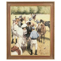
Polo Painting by Rossi, at the Polo Match
By Alberto Rossi
Located in Oxfordshire, GB
Polo oil painting "At The Polo Match", By Alberto Rossi.
This is a beautiful colourful original oil on board painting by renowned Italian artist Al...
Category
Antique 1890s Italian Sporting Art Decorative Art
Materials
Paper
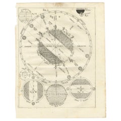
Antique Map Illustrating Solar Eclipses by Scherer, C.1703
Located in Langweer, NL
Antique map of an hemisphere and several figures illustrating the position of the earth, moon and sun. Printed for Scherer's 'Atlas Novus' (1702-1710).
Artists and Engravers: Heinrich Scherer (1628-1704) was a Professor of Hebrew, Mathematics and Ethics at the University of Dillingen until about 1680. Thereafter he obtained important positions as Official Tutor to the Royal Princes...
Category
Antique 18th Century Maps
Materials
Paper
$123 Sale Price
53% Off
H 10.63 in W 8.47 in D 0 in
Still Thinking About These?
All Recently ViewedMore Ways To Browse
Skateboard Furniture
Wood Surfboards
Wooden Surfboard
Rare Vintage Surfboard
Vintage Wooden Surfboard
Antique Wood Stirrups
Antique Wooden Press
Cowboy Antiques
Cricket Ball
Ebony Walking Canes
Hardy Palakona
Parade Saddle
Pick Axe
Retro Football Ball
St Andrews Golf Club
Tom Morris
Used Bamboo Fly Rod
Used Pick Axe