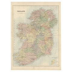
Items Similar to Early 20th c. Ireland Perrier Motor Map c.1910


Want more images or videos?
Request additional images or videos from the seller
1 of 7
Early 20th c. Ireland Perrier Motor Map c.1910
$275
£209.75
€238.86
CA$386.46
A$421.49
CHF 223.28
MX$5,053.04
NOK 2,843.54
SEK 2,600.21
DKK 1,784.48
About the Item
ABOUT
Large bright vivid color-printed Perrier Motor Map, featuring the motoring roads of Ireland. Mounted to original linen back, folded into a cloth waterproof slipcase. Manufactured in London, circa 1910.
Perfect for framing. England/Wales and Scotland also available.
CREATOR Perrier. London, U.K.
DATE OF MANUFACTURE c.1910.
MATERIALS AND TECHNIQUES Linen, Paper.
CONDITION Good. Wear consistent with age and use.
DIMENSIONS H 47.5 in. W 37.5 in. (open), Slipcase: 10.25 in. W 8.25 in. D .5 in.
HISTORY
Unknown.
- Dimensions:Height: 47.5 in (120.65 cm)Width: 37.5 in (95.25 cm)Depth: 0.25 in (6.35 mm)
- Style:Victorian (Of the Period)
- Materials and Techniques:
- Place of Origin:
- Period:
- Date of Manufacture:1910
- Condition:Wear consistent with age and use.
- Seller Location:San Francisco, CA
- Reference Number:Seller: Posters SKU 0541stDibs: LU1280240800752
About the Seller
5.0
Platinum Seller
Premium sellers with a 4.7+ rating and 24-hour response times
Established in 2014
1stDibs seller since 2015
1,355 sales on 1stDibs
Typical response time: <1 hour
- ShippingRetrieving quote...Shipping from: San Francisco, CA
- Return Policy
More From This Seller
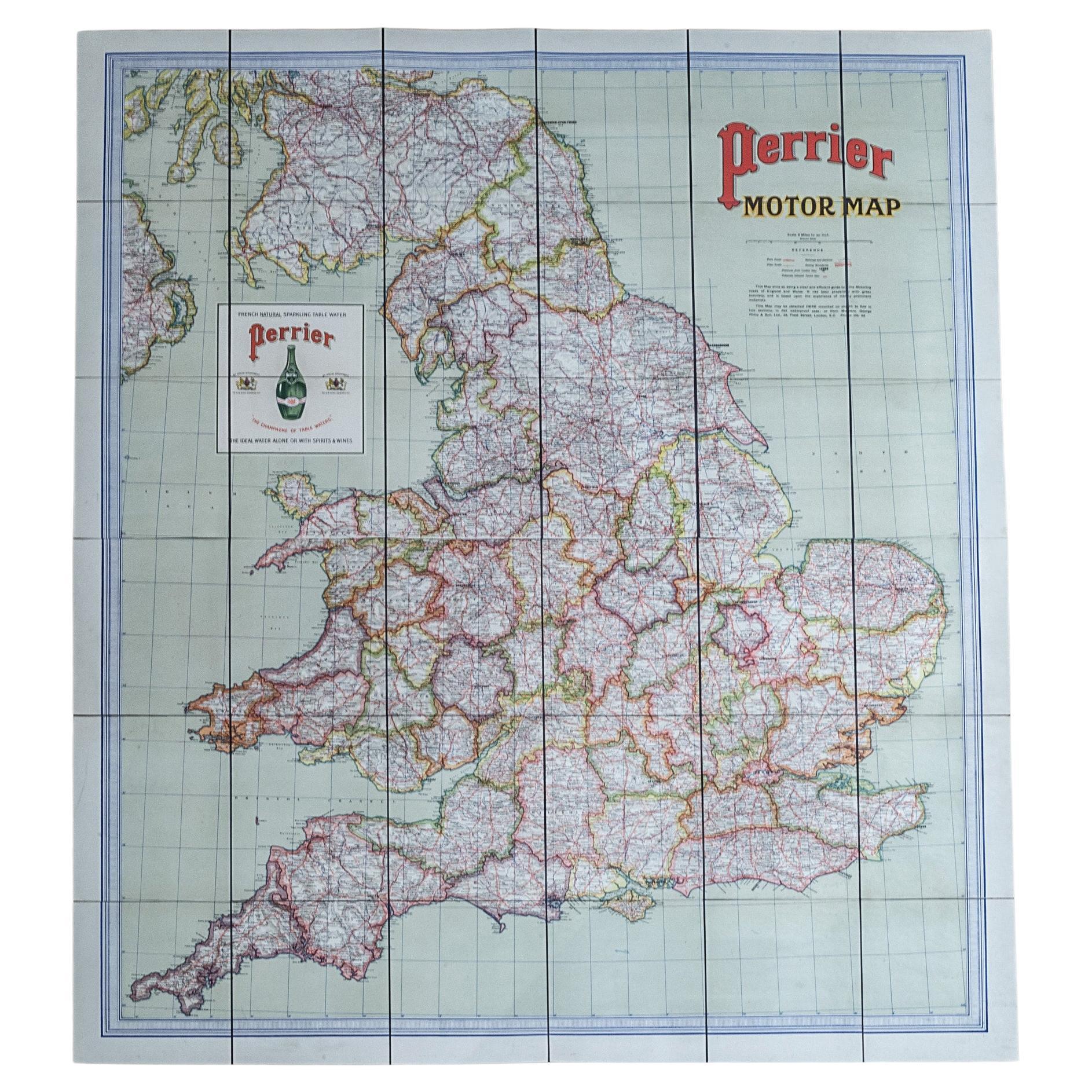
View AllEarly 20th c. England and Wales Perrier Motor Map c.1910
Located in San Francisco, CA
ABOUT
Large bright vivid color-printed Perrier Motor Map, featuring the motoring roads of England and Wales. Segmented in two sections and mounted to original linen back, folded int...
Category
Early 20th Century British Victorian Globes
Materials
Paper, Linen
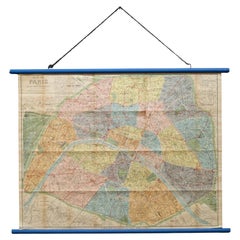
Early 20th c. Plan of Paris Map Hanging Scroll c.1920
Located in San Francisco, CA
ABOUT
An original folding map of the Paris on two dowels and hanging chain. Linen backed.
CREATOR France by L. Guilmin. Paris, France.
DATE OF MANUFACTURE c.1920.
MAT...
Category
Early 20th Century French Art Deco Decorative Art
Materials
Wood, Paper, Linen
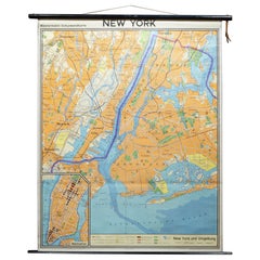
Mid-century German School Wall Map New York City and Vicinity Map c.1962
Located in San Francisco, CA
ABOUT
A mid-century school wall map of NYC and vicinity map in German. Linen backed mounted on two thick black dowels with leather strap.
CREATOR Kartographic und Druck: Georg...
Category
Mid-20th Century German Mid-Century Modern Decorative Art
Materials
Wood, Paper, Linen
$796 Sale Price
20% Off
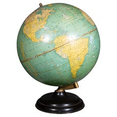
Antique Cram
s Terrestrial Globe c.1930-1940
By George F. Cram
Located in San Francisco, CA
ABOUT
An antique 10 1/2" Cram's terrestrial globe on a round metal base with brass bracket. This piece has retained its original color and finish.
CREATOR George F. Cram Co., I...
Category
Early 20th Century Industrial Globes
Materials
Metal, Brass
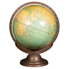
Art Deco Cram
s 12 Inch Terrestrial World Globe c.1930-1939
By George F. Cram
Located in San Francisco, CA
ABOUT
An original Art Deco terrestrial world globe with a cast iron base and metal bracket. The globe rotates within the bracket to adjust it's axis. This piece has retained its ori...
Category
Early 20th Century Industrial Globes
Materials
Metal, Iron
Original Restored Lithograph SNCF French Rail Travel Poster, Languedoc c.1956
Located in San Francisco, CA
ABOUT
Original restored SNCF French lithograph rail travel poster and linen backed.
CREATOR Artist: Jean Jules Louis Cavailles (1901 - 1977). Printer: Perceval, Paris.
DAT...
Category
Mid-20th Century French Mid-Century Modern Posters
Materials
Linen, Paper
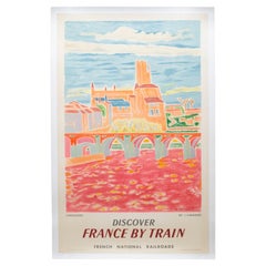
$995 Sale Price
23% Off
You May Also Like
Large Original Antique Map of Ireland. C.1900
Located in St Annes, Lancashire
Fabulous map of Ireland
Original color.
Engraved and printed by the George F. Cram Company, Indianapolis.
Published, C.1900.
Unframed.
Free shipping.
Category
Antique 1890s American Maps
Materials
Paper

Antique Map of Ireland, 1903, with Intricate County Boundaries
Coastal Details
Located in Langweer, NL
Title: Antique Map of Ireland, 1903, with Intricate County Boundaries and Coastal Detail
Description:
This antique map of Ireland, engraved and published in 1903 by the esteemed W. ...
Category
Early 20th Century Maps
Materials
Paper

Antique Ireland Map with County Divisions – Decorative Wall Chart, 1884
Located in Langweer, NL
Antique Map of Ireland with Counties – Black’s Atlas, 1884
Description:
This finely detailed engraved map of Ireland was published in the New and Revised Edition of Black’s General ...
Category
Antique 1880s Scottish Maps
Materials
Paper
Map of Ireland: Early 19th Century - from the 1802 Tardieu Atlas
Located in Langweer, NL
Antique Map Description
**Title:** Carte d'Irlande
**Publication Details:**
- **Atlas Title:** Nouvel Atlas Universel de Géographie Ancienne et Moderne
- **Purpose:** For the Nouve...
Category
Antique Early 1800s Maps
Materials
Paper

$421 Sale Price
20% Off
1882 Cartographic Views of Ireland
s North and South Regions
Located in Langweer, NL
Title: 1882 Maps of Ireland: Northern and Southern Regions
These two maps provide a detailed representation of Ireland as it was in 1882, divided into the northern and southern regi...
Category
Antique 1880s Maps
Materials
Paper
Original Antique Map of Ireland- Tipperary and Waterford. C.1840
Located in St Annes, Lancashire
Great map of Tipperary and Waterford
Steel engraving
Drawn under the direction of A.Adlard
Published by How and Parsons, C.1840
Unframed.
Category
Antique 1840s English Maps
Materials
Paper
