1 of 4
Railroad Water Sign
$1,600List Price
About the Item
- Dimensions:Height: 86 in (218.44 cm)Width: 30 in (76.2 cm)Depth: 17 in (43.18 cm)
- Materials and Techniques:
- Place of Origin:
- Period:
- Date of Manufacture:Late 19th Century
- Condition:Wear consistent with age and use.
- Seller Location:Round Top, TX
- Reference Number:Seller: 11150511stDibs: LU82083385412
Authenticity Guarantee
In the unlikely event there’s an issue with an item’s authenticity, contact us within 1 year for a full refund. DetailsMoney-Back Guarantee
If your item is not as described, is damaged in transit, or does not arrive, contact us within 7 days for a full refund. Details24-Hour Cancellation
You have a 24-hour grace period in which to reconsider your purchase, with no questions asked.Vetted Professional Sellers
Our world-class sellers must adhere to strict standards for service and quality, maintaining the integrity of our listings.Price-Match Guarantee
If you find that a seller listed the same item for a lower price elsewhere, we’ll match it.Trusted Global Delivery
Our best-in-class carrier network provides specialized shipping options worldwide, including custom delivery.You May Also Like
1899 Poole Brothers Antique Railroad Map of the Illinois Central Railroad
Located in Colorado Springs, CO
This is an 1899 railroad map of the Illinois Central and Yazoo and Mississippi Valley Railroads, published by the Poole Brothers. The map focuses on the continuous United States from the Atlantic to the Pacific Oceans, the Gulf of Mexico, and the Antilles. Remarkably detailed, the rail routes of the Illinois Central RR are marked in red, which each stop labeled. Major stops are overprinted in red, bold letters, with the short rail distances to New York listed above the stop and short rail distances to New Orleans listed below the name.
In addition to the Illinois Central network, numerous different rail lines are illustrated and the company running that line is noted along with many stops along each route. Sea routes from New Orleans to locations in Central America, the Caribbean, and Europe are marked and labeled with destination and distance, along with routes originating from Havana. Inset at bottom left is a map of Cuba; an inset map of Puerto Rico...
Category
Antique 1890s American Maps
Materials
Paper

$7,950
H 41 in W 47 in D 1.25 in
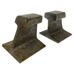
Vintage Modernist Steel Railroad Tie Bookends
By Ward Bennett
Located in San Diego, CA
Vintage heavy train railroad tie track bookends in the style of Ward Bennett. Green felt to bases, smooth metal finish to tops, front and back with textured steel on the sides. Great additions to your Modernist and Mid Century décor...
Category
Vintage 1960s North American Mid-Century Modern Bookends
Materials
Steel
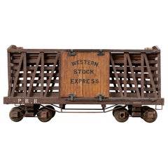
Antique Pennsylvania Railroad Stock Car Model
Located in Dekalb, IL
Antique handmade railroad stock car model.
As a model of the railroad cars designed to haul livestock like cattle, this exquisite replica delivers some remarkable details including ...
Category
Early 20th Century American Models and Miniatures
Materials
Tin
Antique Map 1888 – Southern Texas Railroads, Counties
Settlements
Located in Langweer, NL
Southern Texas Map 1888 – Rand McNally Antique Lithograph
This antique 1888 map of Southern Texas, published by Rand, McNally & Co., depicts the Gulf Coast and borderlands with Mexi...
Category
Antique Late 19th Century American Maps
Materials
Paper
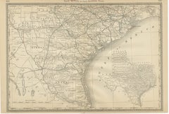
$648
H 14.18 in W 20.67 in D 0.01 in
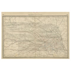
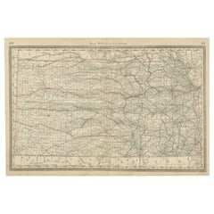
Nebraska Railroad Map 1888 – Rand McNally Antique Lithograph
Located in Langweer, NL
Nebraska Railroad Map 1888 – Rand McNally Antique Lithograph
This finely detailed map of Nebraska, published by Rand, McNally & Co. in 1888, provides an excellent overview of the st...
Category
Antique Late 19th Century American Maps
Materials
Paper
Texas Antique Map 1888 – Railroads, Counties
Frontier Settlements
Located in Langweer, NL
Texas Railroad Map 1888 – Rand McNally Antique Lithograph
This antique 1888 map of Texas, published by Rand, McNally & Co., provides a detailed overview of the state during a critic...
Category
Antique Late 19th Century American Maps
Materials
Paper

$648
H 14.18 in W 20.67 in D 0.01 in
Kansas Railroad Map 1888 – Rand McNally Antique Lithograph
Located in Langweer, NL
Kansas Railroad Map 1888 – Rand McNally Antique Lithograph
This antique 1888 map of Kansas by Rand, McNally & Co. offers a detailed view of the state during a period of rapid expans...
Category
Antique Late 19th Century American Maps
Materials
Paper
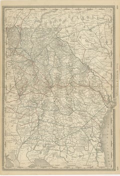
Georgia 1888 Antique Map – Railroads, Settlements
Frontier Counties
Located in Langweer, NL
Georgia Map 1888 – Rand McNally Antique Lithograph
This antique 1888 map of Georgia, published by Rand, McNally & Co., offers a detailed portrayal of the state in the post-Reconstru...
Category
Antique Late 19th Century American Maps
Materials
Paper
$552
H 20.67 in W 14.18 in D 0.01 in
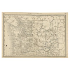
Washington Map 1888 – Antique Railroads, Indian Reservations
Counties
Located in Langweer, NL
Antique Map of Washington – Railroads, Counties & Indian Reservations, 1888
This original engraved map shows the Territory of Washington in 1888, a historically important moment jus...
Category
Antique Late 19th Century American Maps
Materials
Paper
$576
H 14.18 in W 20.67 in D 0.01 in
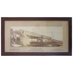
Large Historical Brighton Beach New York Railroad Bridge Photo
By Acme Photo
Located in Cincinnati, OH
A large original vintage historical builders photo of the Brighton Beach railroad bridge at Neptune Ave. Hand lettering on the mat are the names of the ...
Category
Antique Late 19th Century American Industrial Photography
Materials
Paper
Still Thinking About These?
All Recently ViewedMore Ways To Browse
Vintage Wicker Cat Basket
Wood Grape Harvesting Bucket
Advertising Umbrella
Art Nouveau Aquarium
Autographed Guitar
Avery Needle Cases
Bang And Olufsen Vintage Receiver
Bang Olufsen Beosound 9000
Black Powder Cannon
Bliss Toy Piano
Boombox Collection
Braun 310
Braun Audio 310
Braun L50
Browning Training Gun
Bundy Trumpet Used
Cast Iron Alligator
Charles Clifton