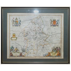
1 of 5
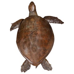
Simulated-Turtle Shell
$5,339.55List Price
About the Item
- Dimensions:Height: 18.51 in (47 cm)Width: 24.02 in (61 cm)Depth: 2.76 in (7 cm)
- Place of Origin:
- Period:
- Date of Manufacture:1920
- Condition:
- Seller Location:Milan, IT
- Reference Number:1stDibs: 130325948770
Authenticity Guarantee
In the unlikely event there’s an issue with an item’s authenticity, contact us within 1 year for a full refund. DetailsMoney-Back Guarantee
If your item is not as described, is damaged in transit, or does not arrive, contact us within 7 days for a full refund. Details24-Hour Cancellation
You have a 24-hour grace period in which to reconsider your purchase, with no questions asked.Vetted Professional Sellers
Our world-class sellers must adhere to strict standards for service and quality, maintaining the integrity of our listings.Price-Match Guarantee
If you find that a seller listed the same item for a lower price elsewhere, we’ll match it.Trusted Global Delivery
Our best-in-class carrier network provides specialized shipping options worldwide, including custom delivery.You May Also Like
Giant Victorian Taxidermy Loggerhead Sea Turtle
Located in Amsterdam, NL
An extremely rare giant Victorian taxidermy Loggerhead sea turtle
England, 19th century
The extremely large animal with a nice patina, with some parts professionally restored and...
Category
Antique 19th Century British Victorian Taxidermy
Materials
Tortoise Shell, Animal Skin, Epoxy Resin, Paint
Turtle Shell with Mother of Pearl and Silver Inlay Purse Mounted in Shadowboxes
Located in Bradenton, FL
Beautiful set of two Mid-Century Modern shell purses. Both have mother of pearl, turquoise and silver inlay and are now mounted in new shadowboxes. Very un...
Category
Mid-20th Century American Bohemian Decorative Art
Materials
Tortoise Shell
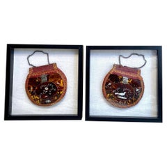
$600
H 13 in W 13 in D 2 in
Rare Set of Four Framed Antique Boxing and Sports Collectible Cards
Located in Bridgeport, CT
Four groups of colored paper collectible sports cards mounted on blue paper pierced in the margin for placing in a notebook. Now mounted on off white card and custom framed.
The cards include images of boxers Al Kaufman, Mike Sullivan, Gans and Nelson and many others. Along with images of track and field and swim athletes. Some faded black printed faded paper ones with portraits of boxers e.g Jack...
Category
Early 20th Century American Classical Sports Equipment and Memorabilia
Materials
Paper
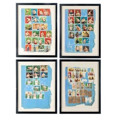
$1,600 / set
H 21.5 in W 16.25 in D 1 in
Large Original Antique Map of The Falkland Islands. 1894
Located in St Annes, Lancashire
Superb Antique map of The Falkland Islands
Published Edward Stanford, Charing Cross, London 1894
Original colour
Good condition
Unframed.
Free shipping
Category
Antique 1890s English Maps
Materials
Paper

$150
Free Shipping
H 22 in W 29.5 in D 0.07 in
Large Original Antique Map of The Canary Islands. 1894
Located in St Annes, Lancashire
Superb Antique map of The Canary Islands
Published Edward Stanford, Charing Cross, London 1894
Original colour
Good condition
Unframed.
Free shipping
Category
Antique 1890s English Maps
Materials
Paper

Blue Hand Painted Baroque Cherub or Angel Portuguese Ceramic Tile or Azulejo
Located in Coimbra, PT
Gorgeous blue hand painted Baroque cherub or angel 18th century style Portuguese ceramic tile/azulejo
The tile painted in cobalt blue over white in typ...
Category
Late 20th Century Portuguese Baroque Decorative Art
Materials
Delft, Faience, Terracotta
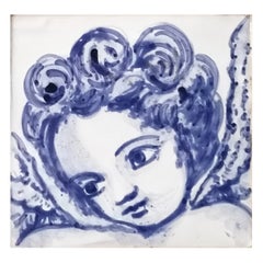
$189
H 0.4 in W 5.91 in D 5.91 in
Double Sided Northamptonshire 1645 Hand Colored Antique Print Map Rare Find
Located in West Sussex, Pulborough
We are delighted to this lovely antique Atlas page map of Northamptonshire printed in 1645 Amsterdam Staffordiensis Comitatvs Vulgo
I have three of th...
Category
Antique Early 1800s English Georgian Maps
Materials
Paper

$615
H 22.25 in W 25.6 in D 0.79 in
Double Sided and Glazed Cheshire 1645 Hand Colored Antique Print Map Rare Find
Located in West Sussex, Pulborough
We are delighted to offer for sale this lovely antique Atlas page map of Cheshire printed in 1645 Amsterdam Staffordiensis Comitatvs Vulgo
I have thre...
Category
Antique Early 1800s English Georgian Maps
Materials
Paper
$615
H 21.46 in W 25.6 in D 0.79 in
Staffordshire 1645 Hand Colored Antique Print Staffordiensis Comitatvs Map
Located in West Sussex, Pulborough
We are delighted to offer for sale this lovely antique Atlas page map of Staffordshire printed in 1645 Amsterdam Staffordiensis Comitatvs Vulgo
This o...
Category
Antique Early 1800s English Georgian Maps
Materials
Paper

$615
H 22.45 in W 25.32 in D 0.99 in
Map Holy Land La Terre Sainte Engraved van Loon Published N de Fer 1703 French
Located in BUNGAY, SUFFOLK
La Terre Sainte, The Holy Land, Tiree Des Memoires De M.De.La Rue. Par N. de Fer. Geographe de Sa Majeste Catoliq et de Monseigneur le Dauphin. Avec Privil du Roi 1703
Detailed map of the Holy Land from Nicholas de Fer's L'Atlas Curieux ou le Monde. East is oriented at the top.
MAKER Nicolas de Fer 1646-1720
The French cartographer and engraver, Nicolas de Fer, was a master at creating maps that were works of art. The maps that he published were printed during the Baroque period when the decorative arts were characterized by ornate detail. De Fer’s detailed maps and atlases were valued more for their decorative content than their geographical accuracy.
Nicolas de Fer was born in 1646. His father, Antoine de Fer, owned a mapmaking firm. At the age of twelve, Nicolas was apprenticed to a Parisian engraver named Louis Spirinx. The family business was starting to decline when his father died in 1673. Nicolas de Fer’s mother, Genevieve, took over the business after the death of her husband. In 1687 the business was passed on to Nicolas and the profits increased after he took over the firm. Nicolas de Fer was a prolific cartographer who produced atlases and hundreds of single maps. He eventually became the official geographer to King Louis XIV of France and King Philip V...
Category
Antique Early 1700s French Louis XIV Maps
Materials
Paper

$2,735
H 11.03 in W 13.78 in D 0.4 in