Items Similar to Original Illustration Map of Alaska by Charles Burki, ca. 1945 – Ink Drawing

Video Loading
Want more images or videos?
Request additional images or videos from the seller
1 of 11
Original Illustration Map of Alaska by Charles Burki, ca. 1945 – Ink Drawing
$1,125.03
£829.91
€940
CA$1,548.54
A$1,672.93
CHF 890.02
MX$20,129.92
NOK 11,269.48
SEK 10,306.25
DKK 7,162.71
About the Item
Original Illustration Map of Alaska by Charles Burki, ca. 1945 – Ink Drawing
Original pen-and-ink illustration of Alaska by Dutch artist Charles Burki (1909–1994), executed around 1945. This superb map design combines Burki’s masterful linework with lively geographic and cultural detail, reflecting his fascination with exploration and visual storytelling during the mid-20th century.
The map shows Alaska in rich graphic detail, featuring the Bering Sea, Gulf of Alaska, and Arctic Circle, as well as settlements such as Anchorage, Fairbanks, Juneau, Cordova, and Nome. Burki’s illustrative embellishments include regional wildlife—a bear, moose, fox, and whale—alongside forested tundra landscapes and natural resource icons for gold, copper, uranium, silver, and coal. At the bottom, a striking vignette of a man paddling a canoe across calm waters anchors the composition, the word “ALASKA” beautifully lettered beneath in ornamental script.
The text block at lower center, written in Dutch, lists the territory’s size, population, and key products: “Bont, Zalm, Naaldhout, Koper, Goud, Uranium, Zilver, IJzer, Steenkool.” Burki’s strong yet elegant draftsmanship—seen in the precise cross-hatching, stippling, and balanced use of white space—confirms his architectural training and mature illustrative skill. This was likely produced for an atlas or educational publication by a Dutch publisher such as Uitgeverij Succes or Het Spectrum.
A rare and visually compelling example of Burki’s postwar map illustrations, blending scientific precision with artistic expression.
Biographical Note:
Charles Burki (1909–1994) was a Dutch painter and illustrator whose career bridged the colonial and post-war eras. Trained in architectural drafting, he moved to the Dutch East Indies in the 1930s and became known for posters and illustrations for local periodicals. During World War II he was imprisoned as a POW; during transport to Japan his ship was bombed and sunk. He survived ten hours at sea, endured imprisonment, and lived through the atomic bombing in Japan at 1,500 meters from impact—an ordeal that profoundly shaped his later art.
After the war Burki returned to the Netherlands, where he became one of the country’s leading illustrators, creating dynamic cover art and maps for Uitgeverij Succes, De Bezige Bij, Het Spectrum, and Kluitman. His precise draughtsmanship, cinematic realism, and restrained palette reflect both technical mastery and lived experience. Today his original gouache and ink boards are prized as rare examples of mid-century Dutch illustration and narrative art.
Condition report:
Good original condition; clean black ink on cream paper. Light creases and small foxing spots visible in margins, consistent with age and original use. Strong impression with excellent tonal contrast.
Framing tips:
Best displayed in a black, walnut, or dark oak frame with a soft ivory mat. A floating mount presentation emphasizes the border and hand-drawn details.
Technique: Pen and ink on paper
Maker: Charles Burki, The Netherlands, ca. 1945
- Dimensions:Height: 13 in (33 cm)Width: 12.21 in (31 cm)Depth: 0.01 in (0.2 mm)
- Materials and Techniques:
- Place of Origin:
- Period:
- Date of Manufacture:ca.1945
- Condition:Good original condition; clean black ink on cream paper. Light creases and small foxing spots visible in margins, consistent with age and original use. Strong impression with excellent tonal contrast.
- Seller Location:Langweer, NL
- Reference Number:Seller: BG-Bea61stDibs: LU3054347066722
About the Seller
5.0
Recognized Seller
These prestigious sellers are industry leaders and represent the highest echelon for item quality and design.
Platinum Seller
Premium sellers with a 4.7+ rating and 24-hour response times
Established in 2009
1stDibs seller since 2017
2,826 sales on 1stDibs
Typical response time: 1 hour
- ShippingRetrieving quote...Shipping from: Langweer, Netherlands
- Return Policy
More From This Seller
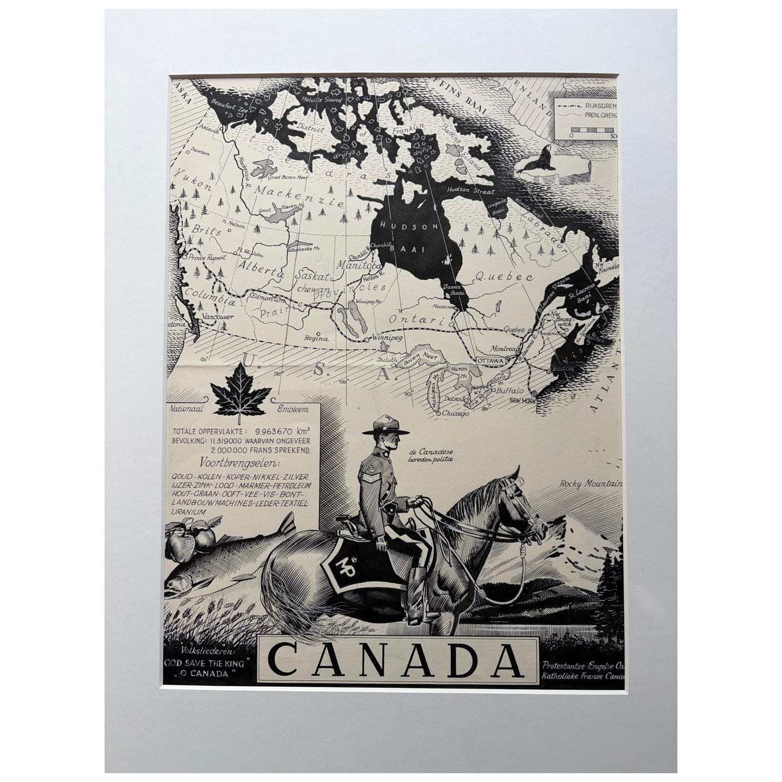
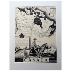
View AllOriginal 1948 Map of Canada by Charles Burki – Art Deco Mountie Illustration
Located in Langweer, NL
Title: Original 1948 Map of Canada by Charles Burki – Mounted Police Illustration and Art Deco Design
This original 1948 pen-and-ink map of Canada by Charles Burki (1909–1994) maste...
Category
Vintage 1940s Dutch Drawings
Materials
Paper
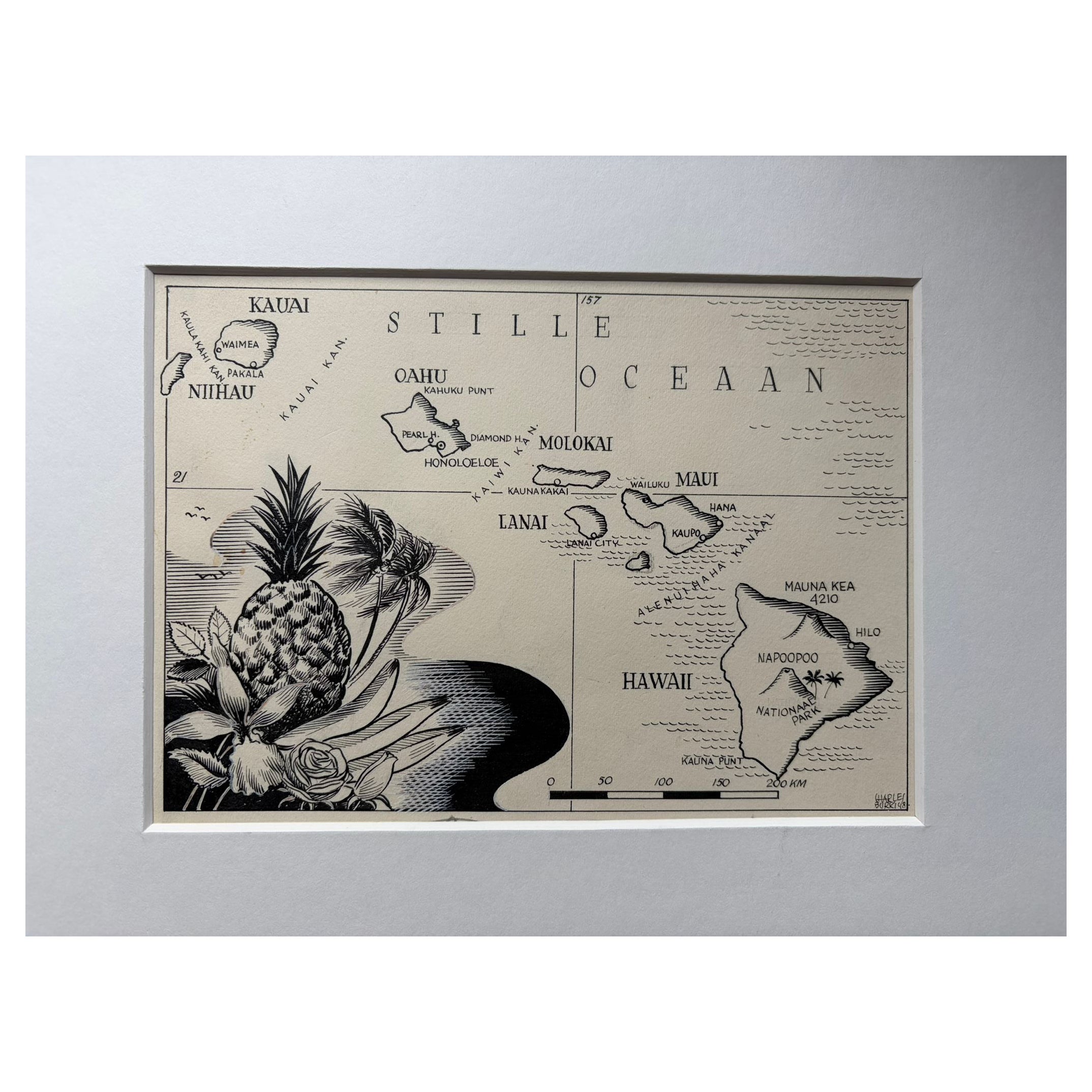
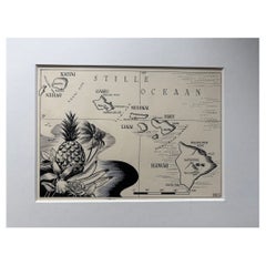
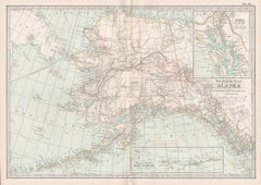
Original Illustration Map of Hawaii by Charles Burki, ca. 1948 – Ink Drawing
Located in Langweer, NL
Original Illustration Map of Hawaii by Charles Burki, ca. 1945 – Ink Drawing
Original pen-and-ink illustration of the Hawaï-Eilanden (Hawaiian Islands) by Dutch artist Charles Burki...
Category
Vintage 1940s Dutch Drawings
Materials
Paper
Antique Map of the Arctic Regions by Lowry
1852
Located in Langweer, NL
Antique map titled 'Arctic Regions'. Original map of the Arctic Regions. This map originates from 'Lowry's Table Atlas constructed and engraved from the most recent Authorities' by J...
Category
Antique Mid-19th Century Maps
Materials
Paper

$95 Sale Price
20% Off
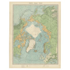
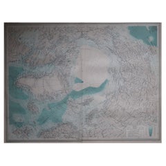
Vintage North Polar Chart Featuring Arctic Exploration Routes, 1903
Located in Langweer, NL
Title: Vintage North Polar Chart Featuring Arctic Exploration Routes, 1903
This vintage map titled "North Polar Chart" offers a fascinating glimpse into early 20th-century Arctic ex...
Category
Early 20th Century Scottish Maps
Materials
Paper
$344 Sale Price
20% Off
19th-Century Decorative Map of British America with Arctic and Pacific Vignettes
Located in Langweer, NL
19th-Century Decorative Map of British America with Arctic and Pacific Vignettes
This 19th-century map of British America, drawn and engraved by J. Rapkin and published by J & F T...
Category
Antique 1850s Maps
Materials
Paper

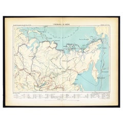
Antique Map of Siberia by Reclus, 1881
Located in Langweer, NL
Antique map titled 'Itineraires en Siberie.' This map shows the itineraries of famous explorers in Siberia between 1648 and 1879. This original old antique print / plate originates f...
Category
Antique 19th Century Maps
Materials
Paper
You May Also Like
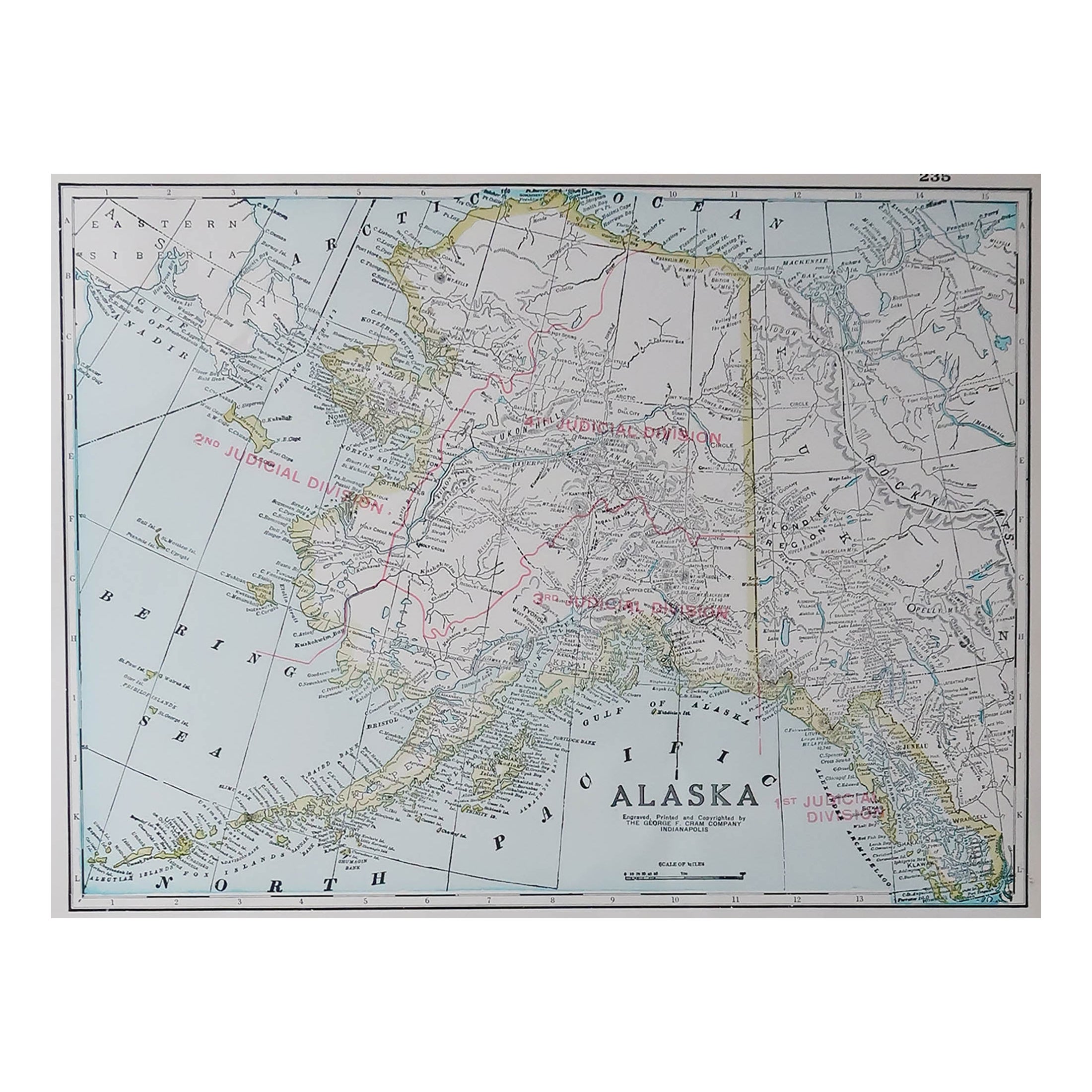
Large Original Antique Map of Alaska, USA, C.1900
Located in St Annes, Lancashire
Fabulous map of Alaska
Original color
Engraved and printed by the George F. Cram Company, Indianapolis.
Published, C.1900
Unframed
Free shipping.
Category
Antique 1890s American Maps
Materials
Paper

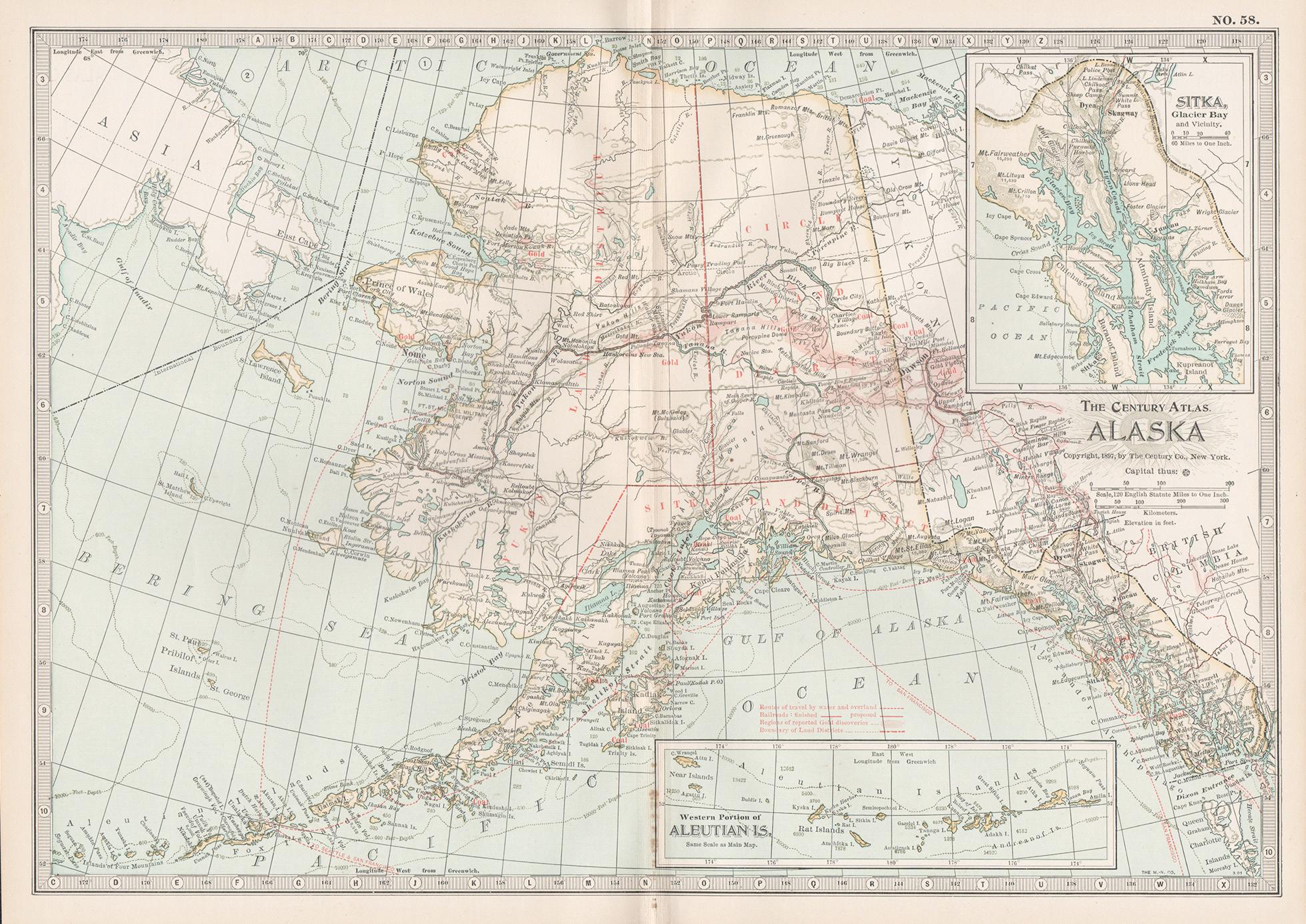
Alaska, North America. Century Atlas antique vintage map
Located in Melbourne, Victoria
'The Century Atlas. Alaska, North America.'
Original antique map, 1903.
Inset maps of 'Sitka, Glacier Bay' and Aleutian Is.'.
Central fold as issued. Map name and number printed on...
Category
Early 20th Century Victorian More Prints
Materials
Lithograph
Alaska, United States of America, Century Atlas state antique vintage map
Located in Melbourne, Victoria
'The Century Atlas. Alaska.' Inset maps of 'Sitka, Glacier Bay' and Aleutian Is.'.
Original antique map, 1903.
Central fold as issued. Map name and number printed on the reverse cor...
Category
Early 20th Century Victorian More Prints
Materials
Lithograph

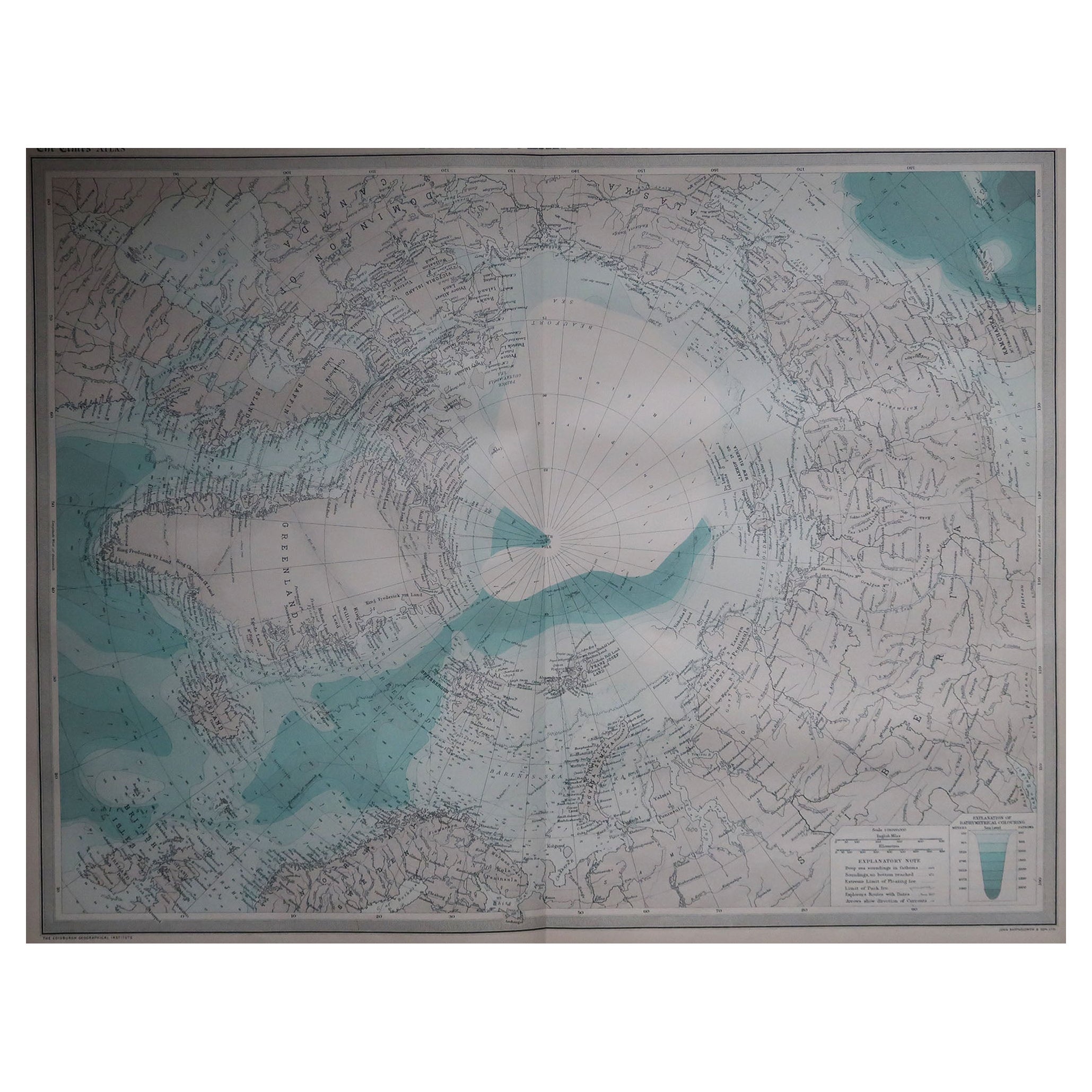
Large Original Vintage Map of The North Pole, circa 1920
Located in St Annes, Lancashire
Great maps of The North Pole.
Unframed.
Original color.
By John Bartholomew and Co. Edinburgh Geographical Institute.
Published, circa 1920.
Free shipp...
Category
Vintage 1920s British Maps
Materials
Paper
Compact by RITZ Map of Alaska
Located in Fulton, CA
A 1950's RITZ compact with original box depicting a map of Alaska with points of interest. Appears to be in original, unused condition.
Compact without box measures:
2.75 inches wi...
Category
Mid-20th Century American Mid-Century Modern Maps
Materials
Metal
Original Antique Map of the American State of Washington, 1903
Located in St Annes, Lancashire
Antique map of Washington
Published By A & C Black. 1903
Original colour
Good condition
Unframed.
Free shipping
Category
Antique Early 1900s English Maps
Materials
Paper
